Location
Latitude: |
35-41-55.3160N (35.698699) |
Longitude: |
085-50-37.7530W (-85.84382) |
Elevation: |
1031.9 feet MSL (315 m MSL) |
Magnetic Variation: |
4.7 W (as of May 2024 from WMM2020 model) |
Time Zone: |
UTC -6.0 (Standard Time) UTC -5.0 (Daylight Savings Time) |
From City: |
03 N.M. W of Mc Minnville, Tennessee |
Found On: |
Atlanta Chart |
FAA Region: |
ASO |
Contacts
Manager: |
Publicly owned: |
| JIM DYER 48 WEST AIRPORT ROAD MC MINNVILLE, TN 37110 931-668-7050 |
WARREN COUNTY WARREN COUNTY COURTHOUSE, 201 LOCUST STREET MCMINNVILLE, TN 37110 931-473-2505 |
Operations
Airport Status: |
Operational |
Facility Use: |
Public |
Type: |
Airport |
Activation Date: |
10/1948 |
Control tower: |
No |
Attendance (Months/Days/Hours): |
Months/Days/Hours ALL/ALL/0800-1700 |
Boundary ARTCC: |
ZME (Memphis) |
Responsible ARTCC: |
ZME (Memphis) |
Lighting Schedule: |
SEE RMK |
Segmented Circle Indicator: |
Yes |
Traffic Pattern Altitude (MSL): |
2032 feet (619 m) |
NOTAMs Facility: |
BNA |
NOTAM-D Service: |
Yes |
International Airport of Entry: |
No |
Customs Landing Rights: |
No |
Military Landing Rights: |
Yes |
Civil/Military Joint Use: |
No |
Based Aircraft
| Single Engine: | 36 |
| Multi Engine: | 6 |
| Jet Engine: | 1 |
Annual Operations (as of 07/03/2023)
| Total Operations: | 24530 | |
| GA Local: | 17000 | 69.3% |
| GA Itinerant: | 7500 | 30.6% |
| Military Aircraft: | 30 | 0.1% |
Communications
| CTAF: | 123.050 |
| Unicom: | 123.050 |
| AWOS-3: | 135.525 (931-668-7056) |
- APCH/DEP SVC PRVDD BY MEMPHIS ARTCC ON FREQS 128.15/323.125 (SHELBYVILLE RCAG).
Fixed Based Operators (FBOs) & Fuel
(Click on a business for detail)
Please help us keep this information up to date. This is a FREE SERVICE just like everything else on Airport Guide! If you see that a business needs to be added, modified, or deleted please fill out our Update Form.
To add, modify, or delete a business click here.
Please help us keep this information up to date. This is a FREE SERVICE just like everything else on Airport Guide! If you see that a business needs to be added, modified, or deleted please fill out our Update Form.
Area Code: 931 |
| Business Name | Frequency | Phone | Fuel Grade |
|---|
Flight Service Stations
| Primary | Alternate | |
| FSS on Field: | N | |
| FSS Name (ID): | Nashville(BNA) | |
| Frequency: | ||
| Toll Free Phone: | 1-800-WX-BRIEF |
Instrument Procedures / Charts
FAA Terminal Procedures valid from 0901Z 03/21/24 to 0901Z 04/18/24.
There are various types of charts available for an airport. They are listed in the Page Type column. Here is a legend for those types:
APD - Airport Diagram
DP - Departure Procedure Charts
HOT - Hot Spots
IAP - Instrument Approach Procedure Charts
MIN - Minimums
STAR - Standard Terminal Arrival Charts
| Page Type | Page Name | Volume | Action Since Last Cycle |
|---|---|---|---|
| IAP | RNAV (GPS) RWY 05 | SE-1 | Changed |
| IAP | RNAV (GPS) RWY 23 | SE-1 | Changed |
| MIN | ALTERNATE MINIMUMS | SE-1 | |
| MIN | TAKEOFF MINIMUMS | SE-1 |
Terminal Procedures are only available for airports in several countries with more being added all the time. If you are looking for a specific country's charts, please send an email to support(at)airportguide.com stating the country name. This will be used to prioritize the implementation.
Navigation Aids (Navaids) near RNC
| Dist (NM) | ID | Morse Code | Name | Type | Freq | True Hdg | Mag Hdg |
|---|---|---|---|---|---|---|---|
| 5.0 | RN | . _ . _ . | Warri | NDB | 209 | 50 | 55 |
| 17.2 | SKN | . . . _ . _ _ . | Hurricane | NDB | 256 | 5 | 10 |
| 21.4 | HEM | . . . . . _ _ | Huchn | NDB | 233 | 35 | 40 |
| 24.1 | ULH | . . _ . _ . . . . . . | Burwi | NDB | 332 | 233 | 238 |
| 27.4 | UXM | . . _ _ . . _ _ _ | Tullahoma Regional | VOR | 109.65 | 225 | 230 |
| 30.1 | FQW | . . _ . _ _ . _ . _ _ | Walter Hill | NDB | 371 | 301 | 306 |
| 30.2 | SYI | . . . _ . _ _ . . | Shelbyville | VOR-DME | 113.55 | 254 | 259 |
| 32.9 | SYI | . . . _ . _ _ . . | Bomar | FAN MARKER | 247 | 252 | |
| 33.1 | BGF | _ . . . _ _ . . . _ . | Boiling Fork | NDB | 263 | 199 | 204 |
| 33.9 | SWZ | . . . . _ _ _ _ . . | Sewart | NDB | 391 | 297 | 302 |
| 37.2 | MQY | _ _ _ _ . _ _ . _ _ | Smyrna | VOT | 110.20 | 299 | 304 |
| 37.4 | JUE | . _ _ _ . . _ . | Lebanon | NDB | 414 | 322 | 327 |
| 40.4 | APT | . _ . _ _ . _ | Jasper | NDB | 382 | 161 | 166 |
| 42.4 | HCH | . . . . _ . _ . . . . . | Hinch Mountain | VOR-DME | 117.60 | 83 | 88 |
| 46.3 | CQN | _ . _ . _ _ . _ _ . | Daisy | NDB | 341 | 133 | 138 |
| 46.4 | DTE | _ . . _ . | Mark Anton | NDB | 394 | 106 | 111 |
| 46.9 | BNA | _ . . . _ . . _ | Nashville Metropoln | VOT | 108.60 | 302 | 306 |
| 48.1 | TNY | _ _ . _ . _ _ | Kelso | NDB | 358 | 225 | 229 |
| 48.6 | BNA | _ . . . _ . . _ | Nashville | VORTAC | 114.10 | 303 | 307 |
| 48.6 | LUG | . _ . . . . _ _ _ . | Verona | NDB | 251 | 256 | 260 |
Nearby Airports with Fuel
Notices to Airmen (NOTAMS)
Remarks
| A110-4 | FOR CD CTC MEMPHIS ARTCC AT 901-368-8453/8449. |
| A17 | AFT HR SVC - 931-607-2629; CLSD THANKSGIVING & CHRISTMAS. |
| A43-05 | PAPI UNUSBL BYD 7 DEGS LEFT OF CNTRLN. |
| A57-23 | OBSTN CLNC SLOPE 40:1 AT DTHR. |
| A81-APT | ACTVT REIL RWY 05 & 23; PAPI RWY 05 & 23; MIRL RWY 05/23 - CTAF. MIRL RWY 05/23 PRESET LOW INTST; INCR INTST - CTAF. |
Runways
Runway Summary
| Runways: | 05/23 |
| Longest Runway: | 05/23 is 5000 ft (1524 m) long |
| Runways with an Instrument Approach: |
RNC Airport Runway Details
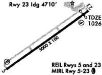
| Runway 05/23 | 5000 ft x 100 ft (1524 m x 30 m) | |
| Runway Length Source: | 3RD PARTY SURVEY as of 08/18/2018 | |
| Surface: | Asphalt - Good condition - No special surface treatment | |
| Runway Pavement Class: | 39 /F/C/X/T | |
| Runway Edge Lights: | Medium Intensity | |
Runway Weight Bearing Capacity (in thousands of pounds) |
||
| Single Wheel Landing Gear: | 29.0 | |
| Dual Wheel Landing Gear: | 48.0 | |
Runway 05 |
Runway 23 |
|
Elevation: |
1031.9 | 1026.4 |
Latitude: |
35-41-39.6140N | 35-42-11.0169N |
Longitude: |
085-51-01.1608W | 085-50-14.3426W |
|
Runway True Alignment: |
051 | 231 |
Glide Path Angle: |
3.5 degrees | 3.0 degrees |
Traffic Pattern: |
Left | Left |
Runway Markings Type: |
Nonprecision Instrument | Nonprecision Instrument |
Runway Markings Condition: |
Good | Good |
Object at End: |
TREES | |
Object Height: |
107 | |
Distance from End: |
1797 | |
Object Centerline Offset: |
349 ft. right of centerline | |
Visual Glide Slope Indicators: |
4-Light PAPI On Left Side Of Runway | 4-Light PAPI On Left Side Of Runway |
REIL: |
Yes | Yes |
Threshold Crossing Height: |
35 | 18 |
Services
Bottled Oxygen: |
None |
Bulk Oxygen: |
None |
Fuel Available: |
100LL |
Landing Fees: |
No |
Parking: |
Tiedowns available |
Maps & Diagrams
RNC Sectional
Flight Planning
at skyvector.com
at skyvector.com