Location
Latitude: |
39-49-49.8450N (39.830513) |
Longitude: |
075-46-11.1130W (-75.769754) |
Elevation: |
435.2 feet MSL (133 m MSL) |
Magnetic Variation: |
11.6 W (as of April 2024 from WMM2020 model) |
Time Zone: |
UTC -5.0 (Standard Time) UTC -4.0 (Daylight Savings Time) |
From City: |
01 N.M. W of Toughkenamon, Pennsylvania |
Found On: |
Washington Chart |
FAA Region: |
AEA |
Contacts
Manager: |
Publicly owned: |
| JONATHAN MARTIN 1235 NEWARK ROAD TOUGHKENAMON, PA 19374 610-268-2619 |
NEW GARDEN TOWNSHIP TOWNSHIP MANAGER, 299 STARR RD. LANDENBURG, PA 19350 610-268-2915 |
Operations
Airport Status: |
Operational |
Facility Use: |
Public |
Type: |
Airport |
Activation Date: |
01/1968 |
Control tower: |
No |
Attendance (Months/Days/Hours): |
Months/Days/Hours ALL/ALL/0800 - 1700 |
Boundary ARTCC: |
ZNY (New York) |
Responsible ARTCC: |
ZNY (New York) |
Lighting Schedule: |
SEE RMK |
Segmented Circle Indicator: |
No |
Traffic Pattern Altitude (MSL): |
1435 feet (437 m) |
NOTAMs Facility: |
IPT |
NOTAM-D Service: |
Yes |
International Airport of Entry: |
No |
Customs Landing Rights: |
No |
Based Aircraft
| Single Engine: | 116 |
| Multi Engine: | 3 |
| GA Helicopters: | 2 |
| Gliders: | 6 |
Annual Operations (as of 02/21/2023)
| Total Operations: | 27332 | |
| Air Taxi: | 450 | 1.6% |
| GA Local: | 23350 | 85.4% |
| GA Itinerant: | 3332 | 12.2% |
| Military Aircraft: | 200 | 0.7% |
Communications
| CTAF: | 123.050 |
| Unicom: | 123.050 |
| Approach: | PHILADELPHIA 124.35 124.35 124.35 |
| Departure: | PHILADELPHIA 124.35 124.35 124.35 |
Fixed Based Operators (FBOs) & Fuel
(Click on a business for detail)
Please help us keep this information up to date. This is a FREE SERVICE just like everything else on Airport Guide! If you see that a business needs to be added, modified, or deleted please fill out our Update Form.
To add, modify, or delete a business click here.
Please help us keep this information up to date. This is a FREE SERVICE just like everything else on Airport Guide! If you see that a business needs to be added, modified, or deleted please fill out our Update Form.
Area Code: 610 |
| Business Name | Frequency | Phone | Fuel Grade |
|---|---|---|---|
| New Garden Aviation
Update FBO info |
Unicom 122.8 | 268-2048 | 80, 100LL |
Flight Service Stations
| Primary | Alternate | |
| FSS on Field: | N | |
| FSS Name (ID): | Williamsport(IPT) | |
| Frequency: | ||
| Toll Free Phone: | 1-800-WX-BRIEF |
Instrument Procedures / Charts
FAA Terminal Procedures valid from 0901Z 03/21/24 to 0901Z 04/18/24.
There are various types of charts available for an airport. They are listed in the Page Type column. Here is a legend for those types:
APD - Airport Diagram
DP - Departure Procedure Charts
HOT - Hot Spots
IAP - Instrument Approach Procedure Charts
MIN - Minimums
STAR - Standard Terminal Arrival Charts
| Page Type | Page Name | Volume | Action Since Last Cycle |
|---|---|---|---|
| IAP | RNAV (GPS) RWY 06 | NE-4 | |
| IAP | RNAV (GPS) RWY 24 | NE-4 | |
| MIN | TAKEOFF MINIMUMS | NE-4 |
Terminal Procedures are only available for airports in several countries with more being added all the time. If you are looking for a specific country's charts, please send an email to support(at)airportguide.com stating the country name. This will be used to prioritize the implementation.
Navigation Aids (Navaids) near N57
| Dist (NM) | ID | Morse Code | Name | Type | Freq | True Hdg | Mag Hdg |
|---|---|---|---|---|---|---|---|
| 7.0 | MXE | _ _ _ . . _ . | Modena | VORTAC | 113.20 | 40 | 52 |
| 11.8 | DQO | _ . . _ _ . _ _ _ _ | Dupont | VORTAC | 114.00 | 140 | 152 |
| 16.6 | IL | . . . _ . . | Hadin | NDB | 248 | 154 | 166 |
| 23.5 | APG | . _ . _ _ . _ _ . | Aberdeen | NDB | 349 | 221 | 233 |
| 24.5 | OOD | _ _ _ _ _ _ _ . . | Woodstown | VORTAC | 112.80 | 118 | 130 |
| 24.8 | PHL | . _ _ . . . . . . _ . . | Philadelphia | VOT | 109.80 | 84 | 96 |
| 25.4 | PTW | . _ _ . _ . _ _ | Pottstown | VORTAC | 116.50 | 22 | 34 |
| 28.5 | ING | . . _ . _ _ . | Ambler | NDB | 275 | 51 | 63 |
| 28.6 | PPM | . _ _ . . _ _ . _ _ | Phillips | VOR-DME | 108.40 | 220 | 231 |
| 29.6 | LRP | . _ . . . _ . . _ _ . | Lancaster | VOR-DME | 117.30 | 306 | 318 |
| 37.8 | ENO | . _ . _ _ _ | Smyrna | VORTAC | 111.40 | 161 | 173 |
| 38.1 | PNE | . _ _ . _ . . | North Philadelphia | VOR | 112.00 | 66 | 78 |
| 38.4 | RNB | . _ . _ . _ . . . | Rainbow | NDB | 363 | 129 | 141 |
| 41.0 | VCN | . . . _ _ . _ . _ . | Cedar Lake | VOR-DME | 115.20 | 115 | 127 |
| 41.7 | UKT | . . _ _ . _ _ | Quakertown | NDB | 208 | 31 | 43 |
| 44.2 | DOV | _ . . _ _ _ . . . _ | Dover | TACAN | 110.00 | 161 | 173 |
| 45.2 | ETX | . _ _ . . _ | East Texas | VOR-DME | 110.20 | 4 | 16 |
| 47.0 | ARD | . _ . _ . _ . . | Yardley | VOR-DME | 108.20 | 57 | 69 |
| 50.7 | MDT | _ _ _ . . _ | Harrisburg | VOT | 110.00 | 296 | 307 |
| 51.1 | BZJ | _ . . . _ _ . . . _ _ _ | Bellgrove | NDB | 328 | 315 | 326 |
Nearby Airports with Fuel
Notices to Airmen (NOTAMS)
Remarks
| A110-1 | RWY 06 NOISE ABATEMENT CLIMB TO 1200 FT MSL BFR TURNING CROSSWIND. |
| A110-2 | FOR ASST AFTER HRS CTC 610-476-1702 |
| A110-3 | DEER AND OTHER WILDLIFE ON AND INVOF ARPT. |
| A110-5 | OVNGT PARKING $10. |
| A110-6 | FOR CD CTC PHILADELPHIA APCH AT 800-354-9884. |
| A33-06/24 | TURF SFC SOUTH OF RWY FOR GLIDER RECOVERY ONLY. |
| A57-06 | CTLG OBSTN EXCEEDS 45 DEG SLP. |
| A58-06 | 12 FT TREES 183 FT FM RWY END & 149 FT RIGHT. |
| A76 | GLIDER OPS INVOF AIRPORT. |
| A81-APT | ACTVT MIRL RWY 06/24 - CTAF. |
| E111 | VFR USE ONLY |
Runways
Runway Summary
| Runways: | 06/24 |
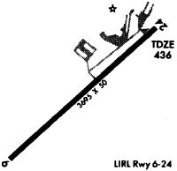
| Longest Runway: | 06/24 is 3693 ft (1126 m) long |
| Runways with an Instrument Approach: |
N57 Airport Runway Details
| Runway 06/24 | 3693 ft x 60 ft (1126 m x 18 m) | |
| Surface: | Asphalt - Excellent condition - No special surface treatment | |
| Runway Edge Lights: | Medium Intensity | |
Runway 06 |
Runway 24 |
|
Elevation: |
433.4 | 429.5 |
Latitude: |
39-49-37.1076N | 39-50-02.5826N |
Longitude: |
075-46-28.0598W | 075-45-54.1643W |
|
Runway True Alignment: |
046 | 226 |
Glide Path Angle: |
0.0 degrees | 0.0 degrees |
Traffic Pattern: |
Left | Left |
Runway Markings Type: |
Nonprecision Instrument | Nonprecision Instrument |
Runway Markings Condition: |
Fair | Fair |
Object at End: |
TREE | TREE |
Object Height: |
59 | 12 |
Distance from End: |
248 | 282 |
Object Centerline Offset: |
239 ft. left of centerline | 120 ft. left of centerline |
Services
Airframe Repair: |
None |
Powerplant Repair: |
None |
Bottled Oxygen: |
None |
Bulk Oxygen: |
None |
Fuel Available: |
100LL |
Maps & Diagrams
N57 Sectional
Flight Planning
at skyvector.com
at skyvector.com