Location
Latitude: |
30-40-43.7000N (30.678806) |
Longitude: |
097-40-45.8000W (-97.679389) |
Elevation: |
789.5 feet MSL (241 m MSL) |
Magnetic Variation: |
3.2 E (as of April 2024 from WMM2020 model) |
Time Zone: |
UTC -6.0 (Standard Time) UTC -5.0 (Daylight Savings Time) |
From City: |
03 N.M. N of Georgetown, Texas |
Found On: |
San Antonio Chart |
FAA Region: |
ASW |
Contacts
Manager: |
Publicly owned: |
| MATTHEW SOMMERFELD 500 TERMINAL DRIVE GEORGETOWN, TX 78628 512-930-8464 |
CITY OF GEORGETOWN PO BOX 409 GEORGETOWN, TX 78627 (512) 930-3666 |
Operations
Airport Status: |
Operational |
Facility Use: |
Public |
Type: |
Airport |
Activation Date: |
10/1945 |
Control tower: |
Yes |
Attendance (Months/Days/Hours): |
Months/Days/Hours ALL/ALL/0700-1900 |
Boundary ARTCC: |
ZHU (Houston) |
Responsible ARTCC: |
ZHU (Houston) |
Lighting Schedule: |
SEE RMK |
Segmented Circle Indicator: |
Yes |
Traffic Pattern Altitude (MSL): |
1790 feet (546 m) |
NOTAMs Facility: |
GTU |
NOTAM-D Service: |
Yes |
International Airport of Entry: |
No |
Customs Landing Rights: |
No |
Military Landing Rights: |
No |
Civil/Military Joint Use: |
No |
Based Aircraft
| Single Engine: | 249 |
| Multi Engine: | 29 |
| Jet Engine: | 30 |
| GA Helicopters: | 19 |
Annual Operations (as of 12/31/2022)
| Total Operations: | 133170 | |
| Air Taxi: | 774 | 0.6% |
| GA Local: | 66536 | 50.0% |
| GA Itinerant: | 65718 | 49.3% |
| Military Aircraft: | 142 | 0.1% |
Communications
| CTAF: | 120.225 |
| Unicom: | 123.000 |
| Tower: | GEORGETOWN 120.225 Hrs: 0700-2200 |
| Clearance Del.: | 119.125 |
| Ground: | 119.125 |
| Approach: | AUSTIN |
| Departure: | AUSTIN |
| ATIS: | 118.6 Hrs: 24. |
| AWOS-3PT: | (512-869-3430) |
Fixed Based Operators (FBOs) & Fuel
(Click on a business for detail)
Please help us keep this information up to date. This is a FREE SERVICE just like everything else on Airport Guide! If you see that a business needs to be added, modified, or deleted please fill out our Update Form.
To add, modify, or delete a business click here.
Please help us keep this information up to date. This is a FREE SERVICE just like everything else on Airport Guide! If you see that a business needs to be added, modified, or deleted please fill out our Update Form.
Area Code: 512 |
| Business Name | Frequency | Phone | Fuel Grade |
|---|---|---|---|
| A.S.M.
Update FBO info |
869-2737 | ||
| Cannan Aviation
Update FBO info |
863-2720 | ||
| Gantt Aviation
Update FBO info |
863-5537 | ||
| Georgetown Municipal Airport
Update FBO info |
Unicom 123.0 | 930-3666 | 100LL, Jet A |
| ICAN Aviation
Update FBO info |
63-7610 | ||
| Pilot's Choice Aviation
Update FBO info |
Unicom 123.5 | 869-1759 | |
| Tejas Avionics/Air Tejas
Update FBO info |
Unicom 122.85 | 863-9566 |
Flight Service Stations
| Primary | Alternate | |
| FSS on Field: | N | |
| FSS Name (ID): | San Angelo(SJT) | |
| Frequency: | ||
| Toll Free Phone: | 1-800-WX-BRIEF |
Instrument Procedures / Charts
FAA Terminal Procedures valid from 0901Z 03/21/24 to 0901Z 04/18/24.
There are various types of charts available for an airport. They are listed in the Page Type column. Here is a legend for those types:
APD - Airport Diagram
DP - Departure Procedure Charts
HOT - Hot Spots
IAP - Instrument Approach Procedure Charts
MIN - Minimums
STAR - Standard Terminal Arrival Charts
| Page Type | Page Name | Volume | Action Since Last Cycle |
|---|---|---|---|
| APD | AIRPORT DIAGRAM | SC-3 | |
| DP | AEROZ TWO (RNAV) | SC-3 | |
| DP | BNDIA THREE (RNAV) | SC-3 | |
| DP | ELOEL THREE (RNAV) | SC-3 | |
| DP | ILEXY FOUR (RNAV) | SC-3 | |
| DP | MUCKY THREE (RNAV) | SC-3 | |
| DP | SAYBR THREE (RNAV) | SC-3 | |
| HOT | HOT SPOT | SC-3 | |
| IAP | RNAV (GPS) RWY 11 | SC-3 | |
| IAP | RNAV (GPS) RWY 18 | SC-3 | |
| IAP | RNAV (GPS) RWY 29 | SC-3 | |
| IAP | RNAV (GPS) RWY 36 | SC-3 | |
| MIN | ALTERNATE MINIMUMS | SC-3 | |
| MIN | TAKEOFF MINIMUMS | SC-3 | |
| STAR | BITER NINE | SC-3 | |
| STAR | KALLA FOUR | SC-3 | |
| STAR | POTRR TWO (RNAV) | SC-3 |
Terminal Procedures are only available for airports in several countries with more being added all the time. If you are looking for a specific country's charts, please send an email to support(at)airportguide.com stating the country name. This will be used to prioritize the implementation.
Navigation Aids (Navaids) near KGTU
| Dist (NM) | ID | Morse Code | Name | Type | Freq | True Hdg | Mag Hdg |
|---|---|---|---|---|---|---|---|
| 0.3 | GUO | _ _ . . . _ _ _ _ | Georgetown | NDB | 332 | 355 | 352 |
| 19.6 | CWK | _ . _ . . _ _ _ . _ | Centex | VORTAC | 112.80 | 156 | 153 |
| 20.8 | IL | . . . _ . . | Iresh | NDB | 278 | 355 | 352 |
| 22.3 | GRK | _ _ . . _ . _ . _ | Gray | VOR-DME | 111.80 | 341 | 338 |
| 27.1 | HLR | . . . . . _ . . . _ . | Hood | NDB | 347 | 356 | 353 |
| 29.0 | BMQ | _ . . . _ _ _ _ . _ | Burnet | NDB | 341 | 277 | 274 |
| 31.1 | GR | _ _ . . _ . | Starn | NDB | 323 | 340 | 337 |
| 34.4 | TPL | _ . _ _ . . _ . . | Temple | DME | 110.4 | 22 | 19 |
| 35.3 | BS | _ . . . . . . | Creed | NDB | 255 | 179 | 176 |
| 38.6 | AGJ | . _ _ _ . . _ _ _ | Gooch Springs | VORTAC | 112.50 | 322 | 319 |
| 45.4 | RU | . _ . . . _ | Garys | NDB | 272 | 197 | 194 |
| 57.6 | LLO | . _ . . . _ . . _ _ _ | Llano | VORTAC | 108.20 | 277 | 274 |
| 58.6 | ROB | . _ . _ _ _ _ . . . | Robinson | NDB | 400 | 32 | 29 |
| 60.2 | STV | . . . _ . . . _ | Stonewall | VORTAC | 113.80 | 242 | 239 |
| 61.5 | MNZ | _ _ _ . _ _ . . | Hamilton | NDB | 251 | 337 | 334 |
| 62.7 | ACT | . _ _ . _ . _ | Waco | VORTAC | 115.30 | 19 | 16 |
| 65.1 | CLL | _ . _ . . _ . . . _ . . | College Station | VORTAC | 113.30 | 93 | 90 |
| 70.2 | CL | _ . _ . . _ . . | Rowdy | NDB | 260 | 98 | 95 |
| 72.3 | IDU | . . _ . . . . _ | Industry | VORTAC | 110.20 | 126 | 123 |
| 74.2 | SAT | . . . . _ _ | San Antonio | VORTAC | 116.80 | 213 | 210 |
Nearby Airports with Fuel
Notices to Airmen (NOTAMS)
Remarks
| A110-1 | DEER ON & INVOF ARPT. |
| A110-2 | MIL HEL OPNS PROHIBITED BTN 2100-0700. |
| A110-3 | PTN OF TWY F NOT VISIBLE FM TWR. |
| A110-4 | FOR CD CTC AUSTIN APCH AT 512-369-7865. |
| A110-5 | RWY 18/36 CLSD TO HEL SKID LDG TO PREVENT DMG TO GROOVED SFC. |
| A16 | EMERG 512-930-8464. |
| A58-29 | 8 FT FENCE 199 FT DSTC, 246 FT L. |
| A81-APT | AFTR TWR HRS, MIRL RWY 18/36 PRESET LOW INTST; TO INCR INTST & ACTVT REILS RWY 18/36 & MIRL RWY 11/29 - CTAF. PAPI RWY 18 & 36 OPS CONSLY. |
| E111 | MIL FIELD PRIOR TO 1940. |
Runways
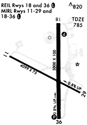
Runway Summary
| Runways: | 11/29 18/36 |
| Longest Runway: | 18/36 is 5004 ft (1525 m) long |
| Runways with an Instrument Approach: |
KGTU Airport Runway Details
| Runway 11/29 | 4099 ft x 75 ft (1249 m x 23 m) | |
| Runway Length Source: | 3RD PARTY SURVEY as of 12/05/2012 | |
| Surface: | Asphalt - Fair condition - No special surface treatment | |
| Runway Edge Lights: | Medium Intensity | |
Runway Weight Bearing Capacity (in thousands of pounds) |
||
| Single Wheel Landing Gear: | 12.5 | |
Runway 11 |
Runway 29 |
|
Elevation: |
789.4 | 758.7 |
Latitude: |
30-40-53.0065N | 30-40-32.3794N |
Longitude: |
097-41-10.2785W | 097-40-29.8599W |
|
Runway True Alignment: |
121 | 301 |
Glide Path Angle: |
0.0 degrees | 0.0 degrees |
Traffic Pattern: |
Left | Right |
Runway Markings Type: |
Nonprecision Instrument | Nonprecision Instrument |
Runway Markings Condition: |
Good | Good |
Object at End: |
TREE | TREE |
Object Height: |
42 | 30 |
Distance from End: |
1425 | 210 |
Object Centerline Offset: |
212 ft. left of centerline | 214 ft. left of centerline |
| Runway 18/36 | 5004 ft x 100 ft (1525 m x 30 m) | |
| Runway Length Source: | 3RD PARTY SURVEY as of 12/05/2012 | |
| Surface: | Asphalt - Fair condition - Saw-cut or plastic grooved | |
| Runway Edge Lights: | Medium Intensity | |
Runway Weight Bearing Capacity (in thousands of pounds) |
||
| Single Wheel Landing Gear: | 30.0 | |
| Dual Wheel Landing Gear: | 60.0 | |
Runway 18 |
Runway 36 |
|
Elevation: |
785.7 | 747.5 |
Latitude: |
30-41-09.2437N | 30-40-19.8165N |
Longitude: |
097-40-40.5019W | 097-40-44.0403W |
|
Runway True Alignment: |
184 | 004 |
Glide Path Angle: |
3.0 degrees | 3.0 degrees |
Traffic Pattern: |
Left | Right |
Runway Markings Type: |
Nonprecision Instrument | Nonprecision Instrument |
Runway Markings Condition: |
Good | Good |
Object at End: |
TREES | TREES |
Object Height: |
37 | 34 |
Distance from End: |
1320 | 1170 |
Object Centerline Offset: |
212 ft. left of centerline | 214 ft. left of centerline |
Visual Glide Slope Indicators: |
4-Light PAPI On Left Side Of Runway | 4-Light PAPI On Left Side Of Runway |
REIL: |
Yes | Yes |
Threshold Crossing Height: |
35 | 50 |
Services
Airframe Repair: |
Major |
Powerplant Repair: |
Major |
Bottled Oxygen: |
Low Pressure |
Fuel Available: |
100LL |
Landing Fees: |
No |
Parking: |
Hangars and tiedowns available |
Maps & Diagrams
KGTU Sectional
Flight Planning
at skyvector.com
at skyvector.com