Location
Latitude: |
35-16-42.5294N (35.27848) |
Longitude: |
089-55-58.7878W (-89.932996) |
Elevation: |
246.8 feet MSL (75 m MSL) |
Magnetic Variation: |
1.9 W (as of April 2024 from WMM2020 model) |
Time Zone: |
UTC -6.0 (Standard Time) UTC -5.0 (Daylight Savings Time) |
From City: |
04 N.M. SW of Millington, Tennessee |
Found On: |
Memphis Chart |
FAA Region: |
ASO |
Contacts
Manager: |
Publicly owned: |
| JASON MCBRIDE 2787 NORTH SECOND STREET MEMPHIS, TN 38127 901-358-0028 |
MEMPHIS SHELBY CO ARPT AUTH 2491 WINCHESTER ROAD, SUITE 113 MEMPHIS, TN 38116-3856 901-922-8000 |
Operations
Airport Status: |
Operational |
Facility Use: |
Public |
Type: |
Airport |
Activation Date: |
06/1949 |
Control tower: |
No |
Attendance (Months/Days/Hours): |
Months/Days/Hours ALL/WED-SAT/0700-1700 |
Boundary ARTCC: |
ZME (Memphis) |
Responsible ARTCC: |
ZME (Memphis) |
Lighting Schedule: |
SS-SR |
Segmented Circle Indicator: |
Yes |
Traffic Pattern Altitude (MSL): |
1247 feet (380 m) |
NOTAMs Facility: |
MKL |
NOTAM-D Service: |
Yes |
International Airport of Entry: |
No |
Customs Landing Rights: |
No |
Military Landing Rights: |
Yes |
Civil/Military Joint Use: |
No |
Based Aircraft
| Single Engine: | 89 |
| Multi Engine: | 9 |
| Gliders: | 1 |
Annual Operations (as of 05/11/2023)
| Total Operations: | 28250 | |
| Air Taxi: | 200 | 0.7% |
| GA Local: | 25000 | 88.5% |
| GA Itinerant: | 3000 | 10.6% |
| Military Aircraft: | 50 | 0.2% |
Communications
| CTAF: | 122.800 |
| Unicom: | 122.800 |
| Approach: | MEMPHIS |
| Departure: | MEMPHIS |
| AWOS-3PT: | 119.575 (901-873-0903) |
Fixed Based Operators (FBOs) & Fuel
(Click on a business for detail)
Please help us keep this information up to date. This is a FREE SERVICE just like everything else on Airport Guide! If you see that a business needs to be added, modified, or deleted please fill out our Update Form.
To add, modify, or delete a business click here.
Please help us keep this information up to date. This is a FREE SERVICE just like everything else on Airport Guide! If you see that a business needs to be added, modified, or deleted please fill out our Update Form.
Area Code: 901 |
| Business Name | Frequency | Phone | Fuel Grade |
|---|---|---|---|
| Shelby Aviation
Update FBO info |
873-3838 | 100LL, Jet A | |

|
 Air BP |
100LL - 2.29 USD per gallon on 10/8/01 |
24 Hour Self Serve Credit Card Pumps |
Flight Service Stations
| Primary | Alternate | |
| FSS on Field: | N | |
| FSS Name (ID): | Jackson(MKL) | |
| Frequency: | ||
| Toll Free Phone: | 1-800-WX-BRIEF |
Instrument Procedures / Charts
FAA Terminal Procedures valid from 0901Z 03/21/24 to 0901Z 04/18/24.
There are various types of charts available for an airport. They are listed in the Page Type column. Here is a legend for those types:
APD - Airport Diagram
DP - Departure Procedure Charts
HOT - Hot Spots
IAP - Instrument Approach Procedure Charts
MIN - Minimums
STAR - Standard Terminal Arrival Charts
| Page Type | Page Name | Volume | Action Since Last Cycle |
|---|---|---|---|
| IAP | RNAV (GPS) RWY 18 | SE-1 | |
| IAP | RNAV (GPS) RWY 36 | SE-1 | |
| MIN | TAKEOFF MINIMUMS | SE-1 | Changed |
Terminal Procedures are only available for airports in several countries with more being added all the time. If you are looking for a specific country's charts, please send an email to support(at)airportguide.com stating the country name. This will be used to prioritize the implementation.
Navigation Aids (Navaids) near 2M8
| Dist (NM) | ID | Morse Code | Name | Type | Freq | True Hdg | Mag Hdg |
|---|---|---|---|---|---|---|---|
| 0.1 | MIG | _ _ . . _ _ . | Millington | NDB | 232 | 359 | 361 |
| 7.4 | SPQ | . . . . _ _ . _ _ . _ | Spain | NDB | 414 | 231 | 233 |
| 13.9 | MEM | _ _ . _ _ | Memphis Metropolitn | VOT | 111.00 | 189 | 191 |
| 14.7 | ME | _ _ . | Elvis | NDB | 287 | 207 | 209 |
| 16.0 | MEM | _ _ . _ _ | Memphis | VORTAC | 117.50 | 188 | 190 |
| 25.2 | COO | _ . _ . _ _ _ _ _ _ | Covington | NDB | 326 | 42 | 44 |
| 26.8 | FYE | . . _ . _ . _ _ . | Somerville | NDB | 255 | 99 | 101 |
| 27.0 | GQE | _ _ . _ _ . _ . | Gilmore | VOR-DME | 113.00 | 278 | 280 |
| 37.3 | HLI | . . . . . _ . . . . | Holly Springs | VORTAC | 112.40 | 144 | 146 |
| 40.4 | GOJ | _ _ . _ _ _ . _ _ _ | Gosnell | VOR | 111.80 | 359 | 361 |
| 48.0 | JBR | . _ _ _ _ . . . . _ . | Jonesboro | VOR-DME | 115.85 | 318 | 320 |
| 49.8 | MKL | _ _ _ . _ . _ . . | Mersy | NDB | 394 | 73 | 75 |
| 53.6 | DYR | _ . . _ . _ _ . _ . | Dyersburg | TACAN | 116.80 | 33 | 35 |
| 53.7 | MKL | _ _ _ . _ . _ . . | Mc Kellar | VOR-DME | 112.00 | 68 | 70 |
| 55.7 | UV | . . _ . . . _ | Tunng | NDB | 426 | 164 | 166 |
| 55.8 | UJM | . . _ . _ _ _ _ _ | Marvell | VOR-DME | 109.60 | 221 | 223 |
| 66.5 | UU | . . _ . . _ | Seyer | NDB | 334 | 103 | 105 |
| 69.5 | SZY | . . . _ _ . . _ . _ _ | Sibley | NDB | 386 | 91 | 93 |
| 70.4 | ARG | . _ . _ . _ _ . | Walnut Ridge | VORTAC | 114.50 | 315 | 317 |
| 73.7 | TNZ | _ _ . _ _ . . | Lawrence County | NDB | 227 | 319 | 321 |
Nearby Airports with Fuel
Notices to Airmen (NOTAMS)
Remarks
| A110-1 | FIXED WING GRASS AREA TKOF OR LNDG NA. |
| A110-3 | FOR CD CTC MEMPHIS APCH AT 901-842-8457. |
| A17 | UNATNDD THANKSGIVING & CHRISTMAS. |
| A30-18U/36U | CLSD INDEF. |
| A53-36U | PLINE 970 FT FM RWY END; MKD WITH ORANGE BALLS. |
| E111 | VFR ONLY. |
Runways
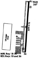
Runway Summary
| Runways: | 18/36 18U/36U |
| Longest Runway: | 18/36 is 3499 ft (1066 m) long |
| Runways with an Instrument Approach: |
2M8 Airport Runway Details
| Runway 18/36 | 3499 ft x 75 ft (1066 m x 23 m) | |
| Runway Length Source: | 3RD PARTY SURVEY as of 02/26/2019 | |
| Surface: | Asphalt - Good condition - No special surface treatment | |
| Runway Edge Lights: | Medium Intensity | |
Runway Weight Bearing Capacity (in thousands of pounds) |
||
| Single Wheel Landing Gear: | 25.0 | |
Runway 18 |
Runway 36 |
|
Elevation: |
246.8 | 242.3 |
Latitude: |
35-17-01.7830N | 35-16-27.2854N |
Longitude: |
089-55-51.4853W | 089-55-54.7433W |
|
Runway True Alignment: |
184 | 004 |
Glide Path Angle: |
4.0 degrees | 4.0 degrees |
Traffic Pattern: |
Left | Right |
Runway Markings Type: |
Nonprecision Instrument | Nonprecision Instrument |
Runway Markings Condition: |
Fair | Fair |
Object at End: |
TREE | TREE |
Object Height: |
76 | 45 |
Distance from End: |
1378 | 956 |
Object Centerline Offset: |
1376 ft. right of centerline | 955 ft. right of centerline |
Visual Glide Slope Indicators: |
2-Light PAPI On Left Side Of Runway | 2-Light PAPI On Left Side Of Runway |
REIL: |
Yes | Yes |
Touchdown Lights: |
No | No |
Centerline Lights: |
No | No |
Threshold Crossing Height: |
40 | 40 |
| Runway 18U/36U | 1600 ft x 75 ft (488 m x 23 m) | |
| Runway Length Source: | ADO as of 05/06/2014 | |
| Surface: | Asphalt - Good condition - No special surface treatment | |
Runway Weight Bearing Capacity (in thousands of pounds) |
||
| Single Wheel Landing Gear: | 4.0 | |
Runway 18U |
Runway 36U |
|
Elevation: |
240.0 | 241.0 |
Latitude: |
35-16-46.0500N | 35-16-30.2400N |
Longitude: |
089-56-10.8500W | 089-56-11.5400W |
|
Runway True Alignment: |
182 | 002 |
Glide Path Angle: |
0.0 degrees | 0.0 degrees |
Runway Markings Type: |
Nonstandard (other than numbers only) | Nonstandard (other than numbers only) |
Runway Markings Condition: |
Poor | Poor |
Object at End: |
TREE | TREES |
Object Height: |
30 | 96 |
Distance from End: |
475 | 1500 |
Object Centerline Offset: |
1376 ft. right of centerline | 955 ft. right of centerline |
REIL: |
No | No |
Touchdown Lights: |
No | No |
Centerline Lights: |
No | No |
Services
Airframe Repair: |
None |
Powerplant Repair: |
None |
Bottled Oxygen: |
None |
Bulk Oxygen: |
None |
Fuel Available: |
100LL, Jet A |
Landing Fees: |
No |
Maps & Diagrams
2M8 Sectional
Flight Planning
at skyvector.com
at skyvector.com