Location
Latitude: |
35-56-25.5000N (35.940417) |
Longitude: |
089-49-50.9000W (-89.830806) |
Elevation: |
255.7 feet MSL (78 m MSL) |
Magnetic Variation: |
2 W (as of April 2024 from WMM2020 model) |
Time Zone: |
UTC -6.0 (Standard Time) UTC -5.0 (Daylight Savings Time) |
From City: |
03 N.M. E of Blytheville, Arkansas |
Found On: |
Memphis Chart |
FAA Region: |
ASW |
Contacts
Manager: |
Publicly owned: |
| PETE MYERS PO BOX 285 BLYTHEVILLE, AR 72316 870-763-0200 |
CITY OF BLYTHEVILLE 124 W. WALNUT BLYTHEVILLE, AR 72315 870-763-3602 |
Operations
Airport Status: |
Operational |
Facility Use: |
Public |
Type: |
Airport |
Activation Date: |
05/1960 |
Control tower: |
No |
Attendance (Months/Days/Hours): |
Months/Days/Hours ALL/ALL/0730-1730 |
Boundary ARTCC: |
ZME (Memphis) |
Responsible ARTCC: |
ZME (Memphis) |
Lighting Schedule: |
SEE RMK |
Segmented Circle Indicator: |
Yes |
Traffic Pattern Altitude (MSL): |
1256 feet (383 m) |
NOTAMs Facility: |
HKA |
NOTAM-D Service: |
Yes |
International Airport of Entry: |
No |
Customs Landing Rights: |
No |
Military Landing Rights: |
Yes |
Civil/Military Joint Use: |
No |
Based Aircraft
| Single Engine: | 9 |
| Multi Engine: | 2 |
| GA Helicopters: | 1 |
Annual Operations (as of 04/30/2020)
| Total Operations: | 18000 | |
| Air Taxi: | 1600 | 8.9% |
| GA Local: | 10000 | 55.6% |
| GA Itinerant: | 6000 | 33.3% |
| Military Aircraft: | 400 | 2.2% |
Communications
| CTAF: | 123.050 |
| Unicom: | 123.050 |
| ASOS: | 135.025 (870-763-8206) |
- APCH/DEP SVC PRVDD BY MEMPHIS ARTCC ON FREQS 134.65/316.15 (MCKELLAR RCAG).
Fixed Based Operators (FBOs) & Fuel
(Click on a business for detail)
Please help us keep this information up to date. This is a FREE SERVICE just like everything else on Airport Guide! If you see that a business needs to be added, modified, or deleted please fill out our Update Form.
To add, modify, or delete a business click here.
Please help us keep this information up to date. This is a FREE SERVICE just like everything else on Airport Guide! If you see that a business needs to be added, modified, or deleted please fill out our Update Form.
Area Code: 870 |
| Business Name | Frequency | Phone | Fuel Grade |
|---|---|---|---|
| Saf-T-Aero
Update FBO info |
Unicom 123.05 | 763-0200, -9691 | 100LL, Jet A |
Flight Service Stations
| Primary | Alternate | |
| FSS on Field: | N | |
| FSS Name (ID): | Jonesboro(JBR) | |
| Frequency: | ||
| Toll Free Phone: | 1-800-WX-BRIEF |
Instrument Procedures / Charts
FAA Terminal Procedures valid from 0901Z 03/21/24 to 0901Z 04/18/24.
There are various types of charts available for an airport. They are listed in the Page Type column. Here is a legend for those types:
APD - Airport Diagram
DP - Departure Procedure Charts
HOT - Hot Spots
IAP - Instrument Approach Procedure Charts
MIN - Minimums
STAR - Standard Terminal Arrival Charts
| Page Type | Page Name | Volume | Action Since Last Cycle |
|---|---|---|---|
| IAP | RNAV (GPS) RWY 18 | SC-1 | |
| IAP | RNAV (GPS) RWY 36 | SC-1 | |
| MIN | ALTERNATE MINIMUMS | SC-1 | |
| MIN | TAKEOFF MINIMUMS | SC-1 |
Terminal Procedures are only available for airports in several countries with more being added all the time. If you are looking for a specific country's charts, please send an email to support(at)airportguide.com stating the country name. This will be used to prioritize the implementation.
Navigation Aids (Navaids) near HKA
| Dist (NM) | ID | Morse Code | Name | Type | Freq | True Hdg | Mag Hdg |
|---|---|---|---|---|---|---|---|
| 5.4 | GOJ | _ _ . _ _ _ . _ _ _ | Gosnell | VOR | 111.80 | 276 | 278 |
| 24.2 | COO | _ . _ . _ _ _ _ _ _ | Covington | NDB | 326 | 150 | 152 |
| 25.3 | DYR | _ . . _ . _ _ . _ . | Dyersburg | TACAN | 116.80 | 79 | 81 |
| 37.0 | JBR | . _ _ _ _ . . . . _ . | Jonesboro | VOR-DME | 115.85 | 264 | 266 |
| 37.1 | MAW | _ _ . _ . _ _ | Malden | TACAN | 111.20 | 353 | 355 |
| 39.9 | MIG | _ _ . . _ _ . | Millington | NDB | 232 | 187 | 189 |
| 45.6 | SPQ | . . . . _ _ . _ _ . _ | Spain | NDB | 414 | 193 | 195 |
| 45.8 | UC | . . _ _ . _ . | Obion | NDB | 212 | 61 | 63 |
| 47.6 | GQE | _ _ . _ _ . _ . | Gilmore | VOR-DME | 113.00 | 221 | 223 |
| 49.0 | FYE | . . _ . _ . _ _ . | Somerville | NDB | 255 | 154 | 156 |
| 49.2 | MKL | _ _ _ . _ . _ . . | Mc Kellar | VOR-DME | 112.00 | 114 | 116 |
| 49.6 | MKL | _ _ _ . _ . _ . . | Mersy | NDB | 394 | 120 | 122 |
| 49.9 | FD | . . _ . _ . . | Earli | NDB | 278 | 331 | 333 |
| 53.9 | MEM | _ _ . _ _ | Memphis Metropolitn | VOT | 111.00 | 187 | 189 |
| 54.0 | ME | _ _ . | Elvis | NDB | 287 | 192 | 194 |
| 55.3 | TNZ | _ _ . _ _ . . | Lawrence County | NDB | 227 | 287 | 289 |
| 55.4 | ARG | . _ . _ . _ _ . | Walnut Ridge | VORTAC | 114.50 | 280 | 282 |
| 56.0 | MEM | _ _ . _ _ | Memphis | VORTAC | 117.50 | 187 | 189 |
| 58.9 | CHQ | _ . _ . . . . . _ _ . _ | Charleston | NDB | 208 | 22 | 24 |
| 66.8 | HZD | . . . . _ _ . . _ . . | Huntingdon | NDB | 217 | 81 | 84 |
Nearby Airports with Fuel
Notices to Airmen (NOTAMS)
Remarks
| A110-1 | NMRS AGRICULTURAL ACFT OPS FM FEB-NOV 250 FT AGL AND BLO. RIGHT & LEFT TPA. |
| A110-2 | FOR CD CTC MEMPHIS ARTCC AT 901-368-8453/8449. |
| A17 | FOR ARPT ATTENDANT AFT HRS CALL 870-740-0798/0660. |
| A81-APT | ACTVT MIRL RY 18/36 - CTAF. PAPI RYS 18 & 36 OPER CONTINUOUSLY. |
| A83 | LGT TEMPORARILY OTS. |
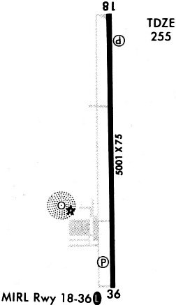
Runways
Runway Summary
| Runways: | 18/36 |
| Longest Runway: | 18/36 is 4999 ft (1524 m) long |
| Runways with an Instrument Approach: |
HKA Airport Runway Details
| Runway 18/36 | 4999 ft x 75 ft (1524 m x 23 m) | |
| Runway Length Source: | 3RD PARTY SURVEY as of 10/31/2009 | |
| Surface: | Asphalt - Fair condition - No special surface treatment | |
| Runway Edge Lights: | Medium Intensity | |
Runway Weight Bearing Capacity (in thousands of pounds) |
||
| Single Wheel Landing Gear: | 15.0 | |
Runway 18 |
Runway 36 |
|
Elevation: |
254.9 | 254.4 |
Latitude: |
35-56-50.1891N | 35-56-00.7609N |
Longitude: |
089-49-51.4523W | 089-49-50.2906W |
|
Runway True Alignment: |
179 | 359 |
Glide Path Angle: |
3.0 degrees | 3.0 degrees |
Traffic Pattern: |
Left | Left |
Runway Markings Type: |
Nonprecision Instrument | Nonprecision Instrument |
Runway Markings Condition: |
Fair | Fair |
Visual Glide Slope Indicators: |
4-Light PAPI On Left Side Of Runway | 4-Light PAPI On Left Side Of Runway |
Threshold Crossing Height: |
48 | 48 |
Services
Airframe Repair: |
Major |
Powerplant Repair: |
Major |
Bottled Oxygen: |
None |
Bulk Oxygen: |
None |
Fuel Available: |
100LL, Jet A |
Landing Fees: |
No |
Parking: |
Hangars and tiedowns available |
Maps & Diagrams
HKA Sectional
Flight Planning
at skyvector.com
at skyvector.com