Location
Latitude: |
45-55-56.4000N (45.932333) |
Longitude: |
089-16-05.8000W (-89.268278) |
Elevation: |
1642.2 feet MSL (501 m MSL) |
Magnetic Variation: |
3.4 W (as of April 2024 from WMM2020 model) |
Time Zone: |
UTC -6.0 (Standard Time) UTC -5.0 (Daylight Savings Time) |
From City: |
00 N.M. NW of Eagle River, Wisconsin |
Found On: |
Green Bay Chart |
FAA Region: |
AGL |
Contacts
Manager: |
Publicly owned: |
| ROBERT HOM PO BOX 2320 EAGLE RIVER, WI 54521 715-479-7442 |
CITY OF EAGLE RIVER PO BOX 2320 EAGLE RIVER, WI 54521 715-479-7442 |
Operations
Airport Status: |
Operational |
Facility Use: |
Public |
Type: |
Airport |
Activation Date: |
02/1938 |
Control tower: |
No |
Attendance (Months/Days/Hours): |
Months/Days/Hours ALL/ALL/0830-1700 |
Boundary ARTCC: |
ZMP (Minneapolis) |
Responsible ARTCC: |
ZMP (Minneapolis) |
Lighting Schedule: |
SEE RMK |
Segmented Circle Indicator: |
Yes |
Traffic Pattern Altitude (MSL): |
2642 feet (805 m) |
NOTAMs Facility: |
EGV |
NOTAM-D Service: |
Yes |
International Airport of Entry: |
No |
Customs Landing Rights: |
No |
Military Landing Rights: |
Yes |
Civil/Military Joint Use: |
No |
Based Aircraft
| Single Engine: | 35 |
| Multi Engine: | 3 |
| Jet Engine: | 1 |
| GA Helicopters: | 2 |
Annual Operations (as of 08/10/2023)
| Total Operations: | 11598 | |
| Commercial: | 88 | 0.8% |
| Air Taxi: | 1500 | 12.9% |
| GA Local: | 4400 | 37.9% |
| GA Itinerant: | 5600 | 48.3% |
| Military Aircraft: | 10 | 0.1% |
Communications
| CTAF: | 122.800 |
| Unicom: | 122.800 |
| AWOS-3: | 118.325 (715-479-1465) |
- APCH/DEP SVC PRVDD BY MINNEAPOLIS ARTCC ON FREQS 133.65/281.5 (RHINELANDER RCAG).
Fixed Based Operators (FBOs) & Fuel
(Click on a business for detail)
Please help us keep this information up to date. This is a FREE SERVICE just like everything else on Airport Guide! If you see that a business needs to be added, modified, or deleted please fill out our Update Form.
To add, modify, or delete a business click here.
Please help us keep this information up to date. This is a FREE SERVICE just like everything else on Airport Guide! If you see that a business needs to be added, modified, or deleted please fill out our Update Form.
Area Code: 715 |
| Business Name | Frequency | Phone | Fuel Grade |
|---|---|---|---|
| Eagle River Union Airport
Update FBO info |
479-7442 | 100LL, Jet A | |
| Williams Aviation
Update FBO info |
479-7442 |
Flight Service Stations
| Primary | Alternate | |
| FSS on Field: | N | |
| FSS Name (ID): | Green Bay(GRB) | |
| Frequency: | ||
| Toll Free Phone: | 1-800-WX-BRIEF |
Instrument Procedures / Charts
FAA Terminal Procedures valid from 0901Z 03/21/24 to 0901Z 04/18/24.
There are various types of charts available for an airport. They are listed in the Page Type column. Here is a legend for those types:
APD - Airport Diagram
DP - Departure Procedure Charts
HOT - Hot Spots
IAP - Instrument Approach Procedure Charts
MIN - Minimums
STAR - Standard Terminal Arrival Charts
| Page Type | Page Name | Volume | Action Since Last Cycle |
|---|---|---|---|
| IAP | LOC/DME RWY 04 | EC-3 | |
| IAP | RNAV (GPS) RWY 04 | EC-3 | |
| IAP | RNAV (GPS) RWY 22 | EC-3 | |
| IAP | VOR/DME RWY 04 | EC-3 | |
| MIN | ALTERNATE MINIMUMS | EC-3 | |
| MIN | TAKEOFF MINIMUMS | EC-3 |
Terminal Procedures are only available for airports in several countries with more being added all the time. If you are looking for a specific country's charts, please send an email to support(at)airportguide.com stating the country name. This will be used to prioritize the implementation.
Navigation Aids (Navaids) near EGV
| Dist (NM) | ID | Morse Code | Name | Type | Freq | True Hdg | Mag Hdg |
|---|---|---|---|---|---|---|---|
| 13.3 | LNL | . _ . . _ . . _ . . | Land O Lakes | NDB | 396 | 10 | 13 |
| 19.2 | ARV | . _ . _ . . . . _ | Arbor Vitae | NDB | 221 | 269 | 272 |
| 19.6 | RHI | . _ . . . . . . . | Rhinelander | VOR-DME | 109.20 | 203 | 206 |
| 20.2 | BDJ | _ . . . _ . . . _ _ _ | Boulder Junction | NDB | 206 | 306 | 309 |
| 20.2 | DO | _ . . _ _ _ | Dougy | NDB | 236 | 253 | 256 |
| 21.4 | RXW | . _ . _ . . _ . _ _ | Watersmeet | NDB | 407 | 358 | 361 |
| 23.4 | RH | . _ . . . . . | Arsha | NDB | 272 | 218 | 221 |
| 46.9 | AIG | . _ . . _ _ . | Antigo | NDB | 347 | 171 | 174 |
| 47.7 | RRL | . _ . . _ . . _ . . | Merrill | NDB | 257 | 202 | 205 |
| 48.3 | PKF | . _ _ . _ . _ . . _ . | Park Falls | NDB | 371 | 271 | 274 |
| 48.8 | IMT | . . _ _ _ | Iron Mountain | VOR-DME | 111.20 | 97 | 101 |
| 49.8 | PBH | . _ _ . _ . . . . . . . | Phillips | NDB | 263 | 254 | 257 |
| 50.6 | IWD | . . . _ _ _ . . | Ironwood | VOR-DME | 108.80 | 315 | 318 |
| 55.2 | OGM | _ _ _ _ _ . _ _ | Ontonagon | NDB | 375 | 355 | 358 |
| 62.1 | FZK | . . _ . _ _ . . _ . _ | Wausau | NDB | 243 | 194 | 197 |
| 66.1 | MDZ | _ _ _ . . _ _ . . | Medford | NDB | 335 | 221 | 224 |
| 66.5 | AUW | . _ . . _ . _ _ | Wausau | VOR-DME | 111.60 | 191 | 194 |
| 77.0 | PH | . _ _ . . . . . | Bayye | NDB | 351 | 192 | 195 |
| 77.0 | RCX | . _ . _ . _ . _ . . _ | Rusk County | NDB | 356 | 251 | 254 |
| 77.8 | ASX | . _ . . . _ . . _ | Ashland | VOR-DME | 110.20 | 299 | 302 |
Nearby Airports with Fuel
Notices to Airmen (NOTAMS)
Remarks
| A110-3 | FOR CD CTC MINNEAPOLIS ARTCC AT 651-463-5588. |
| A17 | FOR ATTENDANT OTR HRS CALL 715-479-7442. |
| A70-FUEL-10 | 0LL 24 HR SELF SVC FUEL AVBL WITH CREDIT CARD. |
| A81-APT | MIRL RWY 04/22 PRESET TO LOW SS-SR; ACTVT AND INCR INTST REIL RWY 4 & 22; PAPI RWY 4 & 22; MIRL RWY 13/31; PERI H1; TWY LGTS - CTAF. |
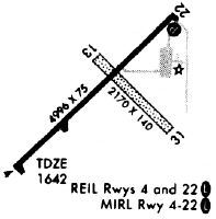
Runways
Runway Summary
| Runways: | 04/22 13/31 H1 |
| Longest Runway: | 04/22 is 5000 ft (1524 m) long |
| Runways with an Instrument Approach: | 04 |
EGV Airport Runway Details
| Runway 04/22 | 5000 ft x 76 ft (1524 m x 23 m) | |
| Runway Length Source: | 3RD PARTY SURVEY as of 08/21/2005 | |
| Surface: | Asphalt - Excellent condition - No special surface treatment | |
| Runway Pavement Class: | 23 /F/C/Y/T | |
| Runway Edge Lights: | Medium Intensity | |
Runway Weight Bearing Capacity (in thousands of pounds) |
||
| Single Wheel Landing Gear: | 12.5 | |
Runway 04 |
Runway 22 |
|
Elevation: |
1640.7 | 1637.4 |
Latitude: |
45-55-37.1441N | 45-56-11.8204N |
Longitude: |
089-16-33.7893W | 089-15-43.4470W |
|
Runway True Alignment: |
045 | 225 |
ILS Type: |
LOC/DME | |
Glide Path Angle: |
3.0 degrees | 3.0 degrees |
Traffic Pattern: |
Left | Left |
Runway Markings Type: |
Nonprecision Instrument | Nonprecision Instrument |
Runway Markings Condition: |
Good | Good |
Object at End: |
TREE | |
Object Height: |
80 | |
Distance from End: |
2745 | |
Object Centerline Offset: |
110 ft. left of centerline | |
Visual Glide Slope Indicators: |
4-Light PAPI On Left Side Of Runway | 4-Light PAPI On Left Side Of Runway |
REIL: |
Yes | Yes |
Touchdown Lights: |
No | No |
Centerline Lights: |
No | No |
Threshold Crossing Height: |
45 | 34 |
| Runway 13/31 | 3400 ft x 60 ft (1036 m x 18 m) | |
| Runway Length Source: | 3RD PARTY SURVEY as of 08/21/2005 | |
| Surface: | Asphalt - Excellent condition - No special surface treatment | |
| Runway Edge Lights: | Medium Intensity | |
Runway 13 |
Runway 31 |
|
Elevation: |
1640.1 | 1640.2 |
Latitude: |
45-56-10.5846N | 45-55-47.9431N |
Longitude: |
089-16-19.4334W | 089-15-43.9255W |
|
Runway True Alignment: |
132 | 312 |
Glide Path Angle: |
0.0 degrees | 0.0 degrees |
Runway Markings Type: |
Basic | Basic |
Runway Markings Condition: |
Fair | Fair |
Object at End: |
TREES | |
Object Height: |
15 | |
Distance from End: |
325 | |
Object Centerline Offset: |
110 ft. left of centerline | |
REIL: |
No | |
Touchdown Lights: |
No | No |
Centerline Lights: |
No |
| Helipad H1 | 60 ft x 60 ft (18 m x 18 m) | |
| Surface: | Asphalt - Excellent condition - No special surface treatment | |
| Runway Edge Lights: | Perimeter lights (for helipads) Intensity | |
Helipad H1 |
||
Glide Path Angle: |
0.0 degrees | 0.0 degrees |
Object Centerline Offset: |
110 ft. left of centerline |
Services
Airframe Repair: |
None |
Powerplant Repair: |
None |
Fuel Available: |
100LL, Jet A+ |
Landing Fees: |
No |
Parking: |
Hangars and tiedowns available |
Maps & Diagrams
EGV Sectional
Flight Planning
at skyvector.com
at skyvector.com