Location
Latitude: |
46-13-11.2000N (46.219778) |
Longitude: |
116-00-49.7000W (-116.013806) |
Elevation: |
1206.0 feet MSL (368 m MSL) |
Magnetic Variation: |
13.3 E (as of May 2024 from WMM2020 model) |
Time Zone: |
UTC -8.0 (Standard Time) UTC -7.0 (Daylight Savings Time) |
From City: |
01 N.M. SE of Kamiah, Idaho |
Found On: |
Great Falls Chart |
FAA Region: |
ANM |
Contacts
Manager: |
Publicly owned: |
| CLEARWATER VALLEY AERO CLUB INC. 121 AIRPORT ROAD KAMIAH, ID 83536 208-935-0089 |
CITY OF KAMIAH PO BOX 338 KAMIAH, ID 83536 208-935-2672 |
Operations
Airport Status: |
Operational |
Facility Use: |
Public |
Type: |
Airport |
Activation Date: |
04/1940 |
Control tower: |
No |
Attendance (Months/Days/Hours): |
Months/Days/Hours ALL/ALL/IRREG |
Boundary ARTCC: |
ZSE (Seattle) |
Responsible ARTCC: |
ZSE (Seattle) |
Lighting Schedule: |
SEE RMK |
Segmented Circle Indicator: |
No |
Traffic Pattern Altitude (MSL): |
2206 feet (672 m) |
NOTAMs Facility: |
BOI |
NOTAM-D Service: |
Yes |
International Airport of Entry: |
No |
Customs Landing Rights: |
No |
Military Landing Rights: |
No |
Civil/Military Joint Use: |
No |
Based Aircraft
| Single Engine: | 12 |
Annual Operations (as of 09/30/2021)
| Total Operations: | 3000 | |
| GA Local: | 2000 | 66.7% |
| GA Itinerant: | 1000 | 33.3% |
Communications
| CTAF: | 122.900 |
Fixed Based Operators (FBOs) & Fuel
(Click on a business for detail)
Please help us keep this information up to date. This is a FREE SERVICE just like everything else on Airport Guide! If you see that a business needs to be added, modified, or deleted please fill out our Update Form.
To add, modify, or delete a business click here.
Please help us keep this information up to date. This is a FREE SERVICE just like everything else on Airport Guide! If you see that a business needs to be added, modified, or deleted please fill out our Update Form.
Area Code: 208 |
| Business Name | Frequency | Phone | Fuel Grade |
|---|---|---|---|
| Kamiah Air Service
Update FBO info |
935-0674 |
Flight Service Stations
| Primary | Alternate | |
| FSS on Field: | N | |
| FSS Name (ID): | Boise(BOI) | |
| Frequency: | ||
| Toll Free Phone: | 1-800-WX-BRIEF |
Instrument Procedures / Charts
Terminal Procedures are only available for airports in several countries with more being added all the time. If you are looking for a specific country's charts, please send an email to support(at)airportguide.com stating the country name. This will be used to prioritize the implementation.
Navigation Aids (Navaids) near S73
| Dist (NM) | ID | Morse Code | Name | Type | Freq | True Hdg | Mag Hdg |
|---|---|---|---|---|---|---|---|
| 20.9 | IDQ | . . _ . . _ _ . _ | Cottonwood | DME | 115.65 | 243 | 230 |
| 36.8 | MQG | _ _ _ _ . _ _ _ . | Nez Perce | VOR-DME | 114.45 | 285 | 272 |
| 57.0 | PUW | . _ _ . . . _ . _ _ | Pullman | VOR-DME | 117.15 | 299 | 285 |
| 75.7 | MLP | _ _ . _ . . . _ _ . | Mullan Pass | VOR-DME | 117.80 | 11 | 358 |
| 84.8 | INE | . . _ . . | Konna | NDB | 521 | 51 | 38 |
| 87.5 | DNJ | _ . . _ . . _ _ _ | Donnelly | VOR-DME | 116.20 | 185 | 172 |
| 89.7 | MSO | _ _ . . . _ _ _ | Missoula | VOR-DME | 112.80 | 61 | 48 |
| 90.7 | AL | . _ . _ . . | Trina | NDB | 353 | 269 | 255 |
| 95.0 | ALW | . _ . _ . . . _ _ | Walla Walla | VOR-DME | 116.40 | 266 | 252 |
| 97.1 | LGD | . _ . . _ _ . _ . . | La Grande | NDB | 296 | 237 | 224 |
| 98.9 | COE | _ . _ . _ _ _ . | Coeur D'alene | VOR-DME | 108.80 | 340 | 326 |
| 99.3 | LEN | . _ . . . _ . | Post Falls | NDB | 347 | 337 | 323 |
Nearby Airports with Fuel
Notices to Airmen (NOTAMS)
Remarks
| A110-1 | FOR RWY CONDS DRG WINT MONTHS CALL AMGR 208-935-0089. |
| A110-2 | NUMEROUS OBSTNS ON BOTH RY APCHS; DOWNDRAFTS PREVALENT OVER RIVER ON RY 32 APCH. |
| A110-4 | CANADIAN GEESE ON AND INVOF ARPT. DEER MAY BE PRSNT ON RWY AT NGT. |
| A110-5 | NOT RMCD TRAN PILOTS LND AFT DARK WO FIRST BCMG FAM WITH ARPT DUE TO HI TRRN .5 MI FM RWY. |
| A110-6 | FOR CD CTC SEATTLE ARTCC AT 253-351-3694. |
| A16 | ALT NMBR: NICK GRACHANIN - 208-935-8061 OR GEORGE HUNT 208-935-2940. |
| A40-14/32 | NSTD LIRL BGN 500 FT FM EACH APCH END - 500 FT UNLGTD DTHR AT BOTH RWY ENDS. |
| A53-32 | YELLOW/BLACK PANEL MARKERS ON RWY 32 THR FENCE. |
| A81-APT | ACTIVATE LIRL RY 14/32 - CTAF. |
| E111 | ESTABD PRIOR TO 5/15/59. |
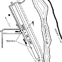
Runways
Runway Summary
| Runways: | 14/32 |
| Longest Runway: | 14/32 is 3000 ft (914 m) long |
| Runways with an Instrument Approach: |
S73 Seaplane Base Runway Details
| Runway 14/32 | 3000 ft x 90 ft (914 m x 27 m) | |
| Surface: | Turf - Good condition - No special surface treatment | |
| Runway Edge Lights: | Non-standard lighting system Intensity | |
Runway 14 |
Runway 32 |
|
Elevation: |
1196.0 | 1206.0 |
Latitude: |
46-13-24.5900N | 46-12-57.7800N |
Longitude: |
116-00-58.7800W | 116-00-40.6400W |
|
Runway True Alignment: |
155 | 335 |
Glide Path Angle: |
0.0 degrees | 0.0 degrees |
Traffic Pattern: |
Right | Left |
Object at End: |
TREES | FENCE |
Object Height: |
70 | 5 |
Object Marked/Lighted?: |
Marked | |
Distance from End: |
325 | 0 |
Object Centerline Offset: |
0 ft. left and right of centerline | 0 ft. left and right of centerline |
Services
Bottled Oxygen: |
None |
Bulk Oxygen: |
None |
Fuel Available: |
100LL |
Landing Fees: |
No |
Other Services: |
Seaplane instruction and rental |
Maps & Diagrams
S73 Sectional
Flight Planning
at skyvector.com
at skyvector.com