Location
Latitude: |
44-58-46.6920N (44.979637) |
Longitude: |
114-44-05.3290W (-114.734814) |
Elevation: |
3626.0 feet MSL (1105 m MSL) |
Magnetic Variation: |
12.7 E (as of April 2024 from WMM2020 model) |
Time Zone: |
UTC -7.0 (Standard Time) UTC -6.0 (Daylight Savings Time) |
From City: |
00 N.M. NE of Bernard, Idaho |
Found On: |
Great Falls Chart |
FAA Region: |
ANM |
Contacts
Manager: |
Publicly owned: |
| MIDDLE FORK RANGER DIST.-USFS 1206 S CHALLIS SALMON, ID 83467 208-756-5554 |
U S FOREST SERVICE 324 25TH ST OGDEN, UT 84401 801-625-5511 |
Operations
Airport Status: |
Operational |
Facility Use: |
Public |
Type: |
Airport |
Activation Date: |
08/1947 |
Control tower: |
No |
Attendance (Months/Days/Hours): |
Months/Days/Hours Unattended |
Boundary ARTCC: |
ZLC (Salt Lake City) |
Responsible ARTCC: |
ZLC (Salt Lake City) |
Segmented Circle Indicator: |
No |
Traffic Pattern Altitude (MSL): |
4626 feet (1410 m) |
NOTAMs Facility: |
BOI |
NOTAM-D Service: |
Yes |
Military Landing Rights: |
No |
Civil/Military Joint Use: |
No |
Based Aircraft
Annual Operations (as of 06/30/2022)
| Total Operations: | 950 | |
| Air Taxi: | 450 | 47.4% |
| GA Itinerant: | 500 | 52.6% |
Communications
| CTAF: | 122.900 |
Fixed Based Operators (FBOs) & Fuel
(Click on a business for detail)
Please help us keep this information up to date. This is a FREE SERVICE just like everything else on Airport Guide! If you see that a business needs to be added, modified, or deleted please fill out our Update Form.
To add, modify, or delete a business click here.
Please help us keep this information up to date. This is a FREE SERVICE just like everything else on Airport Guide! If you see that a business needs to be added, modified, or deleted please fill out our Update Form.
Area Code: 208 |
| Business Name | Frequency | Phone | Fuel Grade |
|---|
Flight Service Stations
| Primary | Alternate | |
| FSS on Field: | N | |
| FSS Name (ID): | Boise(BOI) | |
| Frequency: | ||
| Toll Free Phone: | 1-800-WX-BRIEF |
Instrument Procedures / Charts
Terminal Procedures are only available for airports in several countries with more being added all the time. If you are looking for a specific country's charts, please send an email to support(at)airportguide.com stating the country name. This will be used to prioritize the implementation.
Navigation Aids (Navaids) near U54
| Dist (NM) | ID | Morse Code | Name | Type | Freq | True Hdg | Mag Hdg |
|---|---|---|---|---|---|---|---|
| 27.7 | LKT | . _ . . _ . _ _ | Salmon | VOR-DME | 113.50 | 84 | 71 |
| 63.9 | DNJ | _ . . _ . . _ _ _ | Donnelly | VOR-DME | 116.20 | 258 | 245 |
| 94.0 | DLN | _ . . . _ . . _ . | Dillon | VOR-DME | 113.00 | 79 | 67 |
| 97.6 | IDQ | . . _ . . _ _ . _ | Cottonwood | DME | 115.65 | 312 | 299 |
Nearby Airports with Fuel
| Dist (NM) | Name (Airport IDs) | True Hdg | Mag Hdg | Fuel Grade |
|---|---|---|---|---|
| 35.1 | Challis Airport (CHL KLLJ LLJ) |
140 | 128 | 100, Jet A |
| 37.2 | Lemhi County Airport (SMN KSMN SMN) |
76 | 64 | 100, Jet A |
| 47.0 | Stanley Airport (2U7) |
190 | 177 | 100LL |
| 57.3 | West Fork Lodge Airport (4U7) |
22 | 9 | Mogas |
| 58.3 | Mc Call Municipal Airport (MYL KMYL MYL) |
265 | 252 | 100LL, Jet A, Jet A-1+ |
| 61.9 | Cascade Airport (U70) |
242 | 229 | 100LL, Jet A |
| 74.0 | Council Municipal Airport (U82) |
259 | 246 | 100LL |
| 80.8 | Ravalli County Airport (HRF) |
18 | 5 | 100LL, Jet A, Jet A+ |
| 82.2 | Idaho County Airport (KGIC GIC) |
315 | 302 | 100LL, Jet A |
| 90.5 | Friedman Meml Airport (SUN KSUN SUN) |
167 | 155 | 100LL, Jet A-1+ |
| 91.8 | Kamiah Municipal Airport (S73) |
324 | 311 | 100LL |
| 92.4 | Cottonwood Municipal Airport (S84) |
313 | 300 | 100LL |
| 93.9 | Dillon Airport (DLN KDLN DLN) |
79 | 67 | 100LL, Jet A |
| 97.0 | Stevensville Airport (32S) |
16 | 3 | 100LL |
Notices to Airmen (NOTAMS)
Remarks
| A110-1 | FLYING B PVT ARPT LCTD 1/2 MILE UPSTREAM. |
| A110-2 | NO WINTER MAINTENANCE. |
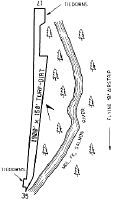
| A110-3 | RCMD LND RWY 35 & TKOF RWY 17; NO TGL OR STOP & GO LDGS; GO AROUNDS NOT RCMD DUE TO STEEP RSG TRRN OFF N END OF RWY 17. |
| A110-6 | NO TELEPHONE AVBL AT ARPT. |
| A110-7 | FOR CD CTC SALT LAKE ARTCC AT 801-320-2568. |
| A33-17/35 | MIDDLE PORTION OF RY ROUGH AND UNEVEN ENTIRE LENGTH. |
| A42-17 | 17/35 EDGES & THLDS MKD WITH WHITE ROCK BOUNDARY MKRS (BMS). |
| A52-17 | RWY 17 +4 FT FENCE AT 0 FT 85 FT R; +500 FT RDG AT 1000 FT ON CNTRLN; +500 FT RDG AT 500 FT 200 FT R; +30 FT RDG AT 200 FT ON CNTRLN. |
| E111 | EXISTED PRIOR TO 31 DEC 1958. |
Runways
Runway Summary
| Runways: | 17/35 |
| Longest Runway: | 17/35 is 1900 ft (579 m) long |
| Runways with an Instrument Approach: |
U54 Airport Runway Details
| Runway 17/35 | 1900 ft x 150 ft (579 m x 46 m) | |
| Surface: | Turf/Dirt - Fair condition - No special surface treatment | |
Runway 17 |
Runway 35 |
|
Glide Path Angle: |
0.0 degrees | 0.0 degrees |
Traffic Pattern: |
Left | Left |
Runway Markings Type: |
None | None |
Object at End: |
TREE | HILL |
Object Height: |
50 | 170 |
Distance from End: |
160 | 1000 |
Object Centerline Offset: |
50 ft. left of centerline | 300 ft. right of centerline |
Services
Airframe Repair: |
Major |
Powerplant Repair: |
Major |
Bottled Oxygen: |
Low Pressure |
Fuel Available: |
100LL |
Landing Fees: |
No |
Parking: |
Tiedowns available |
Maps & Diagrams
U54 Sectional
Flight Planning
at skyvector.com
at skyvector.com