Location
Latitude: |
46-02-19.5710N (46.03877) |
Longitude: |
116-19-53.5250W (-116.331535) |
Elevation: |
3474.0 feet MSL (1059 m MSL) |
Magnetic Variation: |
13.4 E (as of April 2024 from WMM2020 model) |
Time Zone: |
UTC -8.0 (Standard Time) UTC -7.0 (Daylight Savings Time) |
From City: |
01 N.M. SE of Cottonwood, Idaho |
Found On: |
Great Falls Chart |
FAA Region: |
ANM |
Contacts
Manager: |
Publicly owned: |
| CLINT RIENER P O BOX 202 COTTONWOOD, ID 83522 (208) 507-0461 |
CITY OF COTTONWOOD P O BOX 571 COTTONWOOD, ID 83522 208-962-3231 |
Operations
Airport Status: |
Operational |
Facility Use: |
Public |
Type: |
Airport |
Activation Date: |
07/1949 |
Control tower: |
No |
Attendance (Months/Days/Hours): |
Months/Days/Hours IREG |
Boundary ARTCC: |
ZSE (Seattle) |
Responsible ARTCC: |
ZSE (Seattle) |
Lighting Schedule: |
SEE RMK |
Segmented Circle Indicator: |
No |
Traffic Pattern Altitude (MSL): |
4474 feet (1364 m) |
NOTAMs Facility: |
BOI |
NOTAM-D Service: |
Yes |
International Airport of Entry: |
No |
Customs Landing Rights: |
No |
Military Landing Rights: |
No |
Civil/Military Joint Use: |
No |
Based Aircraft
| Single Engine: | 7 |
Annual Operations (as of 07/30/2023)
| Total Operations: | 4000 | |
| GA Local: | 1000 | 25.0% |
| GA Itinerant: | 3000 | 75.0% |
Communications
| CTAF: | 122.900 |
- COMMUNICATIONS PRVDD BY BOISE RADIO ON FREQ 122.2 (COTTONWOOD RCO).
Fixed Based Operators (FBOs) & Fuel
(Click on a business for detail)
Please help us keep this information up to date. This is a FREE SERVICE just like everything else on Airport Guide! If you see that a business needs to be added, modified, or deleted please fill out our Update Form.
To add, modify, or delete a business click here.
Please help us keep this information up to date. This is a FREE SERVICE just like everything else on Airport Guide! If you see that a business needs to be added, modified, or deleted please fill out our Update Form.
Area Code: 208 |
| Business Name | Frequency | Phone | Fuel Grade |
|---|---|---|---|
| Camas Prairie Aviation
Update FBO info |
962-3941, -3985 | 100LL |
Flight Service Stations
| Primary | Alternate | |
| FSS on Field: | N | |
| FSS Name (ID): | Boise(BOI) | |
| Frequency: | ||
| Toll Free Phone: | 1-800-WX-BRIEF |
Instrument Procedures / Charts
Terminal Procedures are only available for airports in several countries with more being added all the time. If you are looking for a specific country's charts, please send an email to support(at)airportguide.com stating the country name. This will be used to prioritize the implementation.
Navigation Aids (Navaids) near S84
| Dist (NM) | ID | Morse Code | Name | Type | Freq | True Hdg | Mag Hdg |
|---|---|---|---|---|---|---|---|
| 5.8 | IDQ | . . _ . . _ _ . _ | Cottonwood | DME | 115.65 | 286 | 273 |
| 30.4 | MQG | _ _ _ _ . _ _ _ . | Nez Perce | VOR-DME | 114.45 | 312 | 299 |
| 53.1 | PUW | . _ _ . . . _ . _ _ | Pullman | VOR-DME | 117.15 | 316 | 302 |
| 76.5 | DNJ | _ . . _ . . _ _ _ | Donnelly | VOR-DME | 116.20 | 175 | 162 |
| 78.0 | AL | . _ . _ . . | Trina | NDB | 353 | 276 | 262 |
| 80.1 | LGD | . _ . . _ _ . _ . . | La Grande | NDB | 296 | 239 | 225 |
| 81.7 | ALW | . _ . _ . . . _ _ | Walla Walla | VOR-DME | 116.40 | 272 | 258 |
| 89.6 | MLP | _ _ . _ . . . _ _ . | Mullan Pass | VOR-DME | 117.80 | 18 | 5 |
| 95.0 | BKE | _ . . . _ . _ . | Baker City | VOR-DME | 115.30 | 221 | 208 |
Nearby Airports with Fuel
Notices to Airmen (NOTAMS)
Remarks
| A110-1 | FOR CD CTC SEATTLE ARTCC AT 253-351-3694. |
| A58-07 | +4 FT FENCE 0 FT FM RY END 50 FT R; +4 FT FENCE 90 FT FM RY END ON CNTRLN' +6 FT POST AT 90 FT 50 FT R. |
| A58-25 | RWY 25 +7 FT FENCE 112 FT FM RWY END ON CNTRLN; +15 FT ROAD 120 FT FM RWY END ON CNTRLN; +7 FT FENCE AT 0 FT 75 FT RIGHT; +15 FT ROAD 0 FT FM RWY END 85 FT RIGHT AND 110 FT LEFT. |
| A81-APT | ACTVT MIRL RY 07/25, PVASI RY 25 AND WINDSOCK LGTS - CTAF. |
| A81-BCN | ACTVT ROTG BCN - CTAF. |
| E111 | ESTABD PRIOR TO 5/15/59. |
Runways
Runway Summary
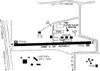
| Runways: | 07/25 |
| Longest Runway: | 07/25 is 3100 ft (945 m) long |
| Runways with an Instrument Approach: |
S84 Airport Runway Details
| Runway 07/25 | 3100 ft x 50 ft (945 m x 15 m) | |
| Surface: | Asphalt - Excellent condition - No special surface treatment | |
| Runway Edge Lights: | Medium Intensity | |
Runway 07 |
Runway 25 |
|
Glide Path Angle: |
0.0 degrees | 5.0 degrees |
Traffic Pattern: |
Left | Left |
Runway Markings Type: |
Basic | Basic |
Runway Markings Condition: |
Good | Good |
Object at End: |
FENCE | |
Object Height: |
5 | |
Distance from End: |
200 | |
Object Centerline Offset: |
0 ft. left and right of centerline | |
Visual Glide Slope Indicators: |
Pulsating/Steady Burning VASI On Right Side Of Runway | |
Threshold Crossing Height: |
50 |
Services
Airframe Repair: |
Major |
Powerplant Repair: |
Major |
Bottled Oxygen: |
Low Pressure |
Bulk Oxygen: |
None |
Fuel Available: |
100LL, Jet A |
Landing Fees: |
No |
Parking: |
Tiedowns available |
Maps & Diagrams
S84 Sectional
Flight Planning
at skyvector.com
at skyvector.com