
Location
Latitude: |
38-17-32.6413N (38.2924) |
Longitude: |
027-09-25.1985E (27.157) |
Elevation: |
412 feet MSL (126 m MSL) |
Magnetic Variation: |
5.5 E (as of April 2024 from WMM2020 model) |
Time Zone: |
UTC +2.0 (Standard Time) UTC +3.0 (Daylight Savings Time) |
Contacts
Manager: |
: |
Operations
Airport Status: |
Operational |
Facility Use: |
Public |
Type: |
Airport |
Traffic Pattern Altitude (MSL): |
1412 feet (430 m) |
Based Aircraft
Annual Operations (as of )
Communications
| MENDERES TWR: | 118.1 |
| MENDERES GND: | 121.9 |
| MENDERES RAMP: | 121.7 |
| MENDERES APP: | 119.5 |
| MENDERES APP: | 134.2 |
| MENDERES ATIS: | 129.2 |
Fixed Based Operators (FBOs) & Fuel
(Click on a business for detail)
Please help us keep this information up to date. This is a FREE SERVICE just like everything else on Airport Guide! If you see that a business needs to be added, modified, or deleted please fill out our Update Form.
To add, modify, or delete a business click here.
Please help us keep this information up to date. This is a FREE SERVICE just like everything else on Airport Guide! If you see that a business needs to be added, modified, or deleted please fill out our Update Form.
| Business Name | Frequency | Phone | Fuel Grade |
|---|
Flight Service Stations
| Primary | Alternate | |
| FSS on Field: | ||
| FSS Name (ID): | ||
| Frequency: | ||
| Toll Free Phone: |
Instrument Procedures / Charts
Terminal Procedures are only available for airports in several countries with more being added all the time. If you are looking for a specific country's charts, please send an email to support(at)airportguide.com stating the country name. This will be used to prioritize the implementation.
Navigation Aids (Navaids) near ADB
| Dist (NM) | ID | Morse Code | Name | Type | Freq | True Hdg | Mag Hdg |
|---|---|---|---|---|---|---|---|
| 0.2 | MEN | Menderes | VOR-DME | 117.90 | 25 | 20 | |
| 0.4 | MEN | Menderes | TACAN | 115.10 | 8 | 3 | |
| 1.6 | EN | Menderes | NDB | 315 | 171 | 166 | |
| 5.6 | ME | Menderes | NDB | 405 | 168 | 163 | |
| 7.2 | IMR | Izmir | VOR-DME | 113.70 | 281 | 276 | |
| 7.3 | KAD | Kadifekale | NDB | 330 | 356 | 351 | |
| 14.0 | CIG | Cigli | TACAN | 113.60 | 330 | 325 | |
| 15.7 | CIG | Cigli | NDB | 363 | 335 | 330 | |
| 15.8 | KLC | Kaklic | TACAN | 116.80 | 327 | 322 | |
| 22.3 | SEL | Efes | NDB | 424 | 157 | 152 | |
| 38.2 | SMO | Samos | NDB | 375 | 197 | 192 | |
| 38.2 | SAM | Samos | VOR-DME | 111.60 | 198 | 193 | |
| 44.6 | AKI | Akhisar | TACAN | 110.20 | 44 | 38 | |
| 47.9 | HOS | Chios | VOR-DME | 110.80 | 274 | 269 | |
| 47.9 | HIO | Chios | NDB | 299 | 273 | 268 | |
| 52.3 | LVO | Lesvos | NDB | 397 | 330 | 324 | |
| 52.8 | MLN | Mitilini | VOR-DME | 109.60 | 330 | 324 | |
| 53.0 | IKA | Ikaria | NDB | 322 | 226 | 221 | |
| 59.0 | MES | Mesta | VOR-DME | 117.60 | 268 | 263 | |
| 63.8 | GML | Kiyikislacik | VOR-DME | 113.90 | 162 | 157 |
Nearby Airports with Fuel
| Dist (NM) | Name (Airport IDs) | True Hdg | Mag Hdg | Fuel Grade |
|---|
Notices to Airmen (NOTAMS)
Remarks
No remarks for this landing facility
Runways
Runway Summary
| Runways: | 16L/34R 16R/34L |
| Longest Runway: | 16L/34R is 10630 ft (3240 m) long |
| Runways with an Instrument Approach: |
ADB Airport Runway Details
| Runway 16L/34R | 10630 ft x 147 ft (3240 m x 45 m) | |
| Runway Edge Lights: | Yes Intensity | |
Runway 16L |
Runway 34R |
|
Elevation: |
412 | 364 |
Latitude: |
38.30659866333 | 38.27819824218 |
Longitude: |
27.152700424194 | 27.161199569702 |
|
Runway True Alignment: |
167 | 347 |
Glide Path Angle: |
0.0 degrees | 0.0 degrees |
REIL: |
Yes | Yes |
Threshold Elevation: |
412 | 364 |
| Runway 16R/34L | 10630 ft x 147 ft (3240 m x 45 m) | |
| Runway Edge Lights: | Yes Intensity | |
Runway 16R |
Runway 34L |
|
Elevation: |
409 | 366 |
Latitude: |
38.30619812011 | 38.27780151367 |
Longitude: |
27.150600433349 | 27.159200668334 |
|
Runway True Alignment: |
167 | 347 |
Glide Path Angle: |
0.0 degrees | 0.0 degrees |
REIL: |
Yes | Yes |
Threshold Elevation: |
409 | 366 |
Services
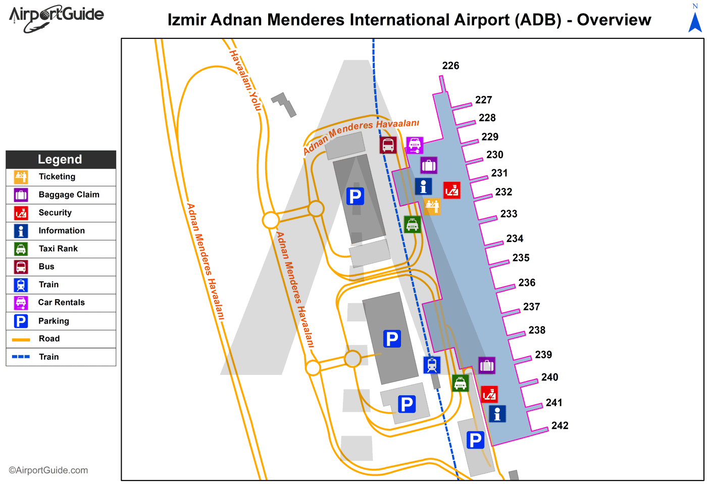
Maps & Diagrams
ADB Sectional
Flight Planning
at skyvector.com
at skyvector.com
