Location
Latitude: |
28-46-37.8410N (28.777178) |
Longitude: |
081-14-05.6890W (-81.234914) |
Elevation: |
54.8 feet MSL (17 m MSL) |
Magnetic Variation: |
7 W (as of March 2025 from WMM2020 model) |
Time Zone: |
UTC -5.0 (Standard Time) UTC -4.0 (Daylight Savings Time) |
From City: |
16 N.M. NE of Orlando, Florida |
Found On: |
Jacksonville Chart |
FAA Region: |
ASO |
Contacts
Manager: |
Publicly owned: |
| NICOLE GUILLET 1200 RED CLEVELAND BLVD SANFORD, FL 32773 407-585-4101 |
SANFORD ARPT AUTHORITY 1200 RED CLEVELAND BLVD, SUITE #200 SANFORD, FL 32773-0818 407-585-4101 |
Operations
Airport Status: |
Operational |
Facility Use: |
Public |
Type: |
Airport |
Activation Date: |
02/1943 |
Control tower: |
Yes |
Attendance (Months/Days/Hours): |
Months/Days/Hours ALL/ALL/ALL |
Boundary ARTCC: |
ZJX (Jacksonville) |
Responsible ARTCC: |
ZJX (Jacksonville) |
Lighting Schedule: |
SEE RMK |
Segmented Circle Indicator: |
Yes |
Traffic Pattern Altitude (MSL): |
1055 feet (322 m) |
NOTAMs Facility: |
SFB |
NOTAM-D Service: |
Yes |
International Airport of Entry: |
No |
Customs Landing Rights: |
Yes |
Military Landing Rights: |
Yes |
Civil/Military Joint Use: |
No |
Aircraft Rescue and Firefighting: |
Class I ARFF Index: D Air Carrier Service: Scheduled Certification Date: 02/1989 |
Based Aircraft
Annual Operations (as of )
Communications
| CTAF: | 120.300 |
| Tower: | SANFORD 120.3 254.35 135.25 Hrs: 0630-2300 |
| Clearance Del.: | 123.975 |
| Ground: | 121.35 254.35 |
| Approach: | ORLANDO |
| Departure: | ORLANDO |
| ATIS: | 125.975 Hrs: 24 |
| ASOS: | 125.975 (407-321-9384) |
| EMERG: | 121.5 |
- 123.975 CLNC DEL AVBL WHEN ADVERTISED ON ATIS.
- SAID IN USE. OPERATE TRANSPONDERS WITH ALTITUDE REPORTING MODE AND ADS-B (IF EQUIPPED) ENABLED ON ALL AIRPORT SURFACES.
Fixed Based Operators (FBOs) & Fuel
(Click on a business for detail)
Please help us keep this information up to date. This is a FREE SERVICE just like everything else on Airport Guide! If you see that a business needs to be added, modified, or deleted please fill out our Update Form.
To add, modify, or delete a business click here.
Please help us keep this information up to date. This is a FREE SERVICE just like everything else on Airport Guide! If you see that a business needs to be added, modified, or deleted please fill out our Update Form.
Area Code: 407 |
| Business Name | Frequency | Phone | Fuel Grade |
|---|---|---|---|
| CE Avionics, Inc.
Update FBO info |
323-0200 | ||
| Comair Aviation Academy
Update FBO info |
Unicom 123.5 | 800-822-6359, 330-7020 | 100LL |
| Orlando Jet Center
Update FBO info |
Unicom 122.85 | 328-8440, 800-382-8440 | 100LL, Jet A |
| Orlando Sanford Aircraft Sales, Inc.
Update FBO info |
800-276-6661, 322-3662 | ||
| Southern Jet Center
Update FBO info |
323-7288 | ||
| StarPort
Update FBO info |
Unicom 122.95, Arinc 130.5 | 321-8880, 866-321-8880 | 100LL, Jet A |
Flight Service Stations
| Primary | Alternate | |
| FSS on Field: | N | |
| FSS Name (ID): | Saint Petersburg(PIE) | |
| Frequency: | ||
| Toll Free Phone: | 1-800-WX-BRIEF |
Instrument Procedures / Charts
FAA Terminal Procedures valid from 0901Z 03/20/25 to 0901Z 04/17/25.
There are various types of charts available for an airport. They are listed in the Page Type column. Here is a legend for those types:
APD - Airport Diagram
DP - Departure Procedure Charts
HOT - Hot Spots
IAP - Instrument Approach Procedure Charts
MIN - Minimums
STAR - Standard Terminal Arrival Charts
Terminal Procedures are only available for airports in several countries with more being added all the time. If you are looking for a specific country's charts, please send an email to support(at)airportguide.com stating the country name. This will be used to prioritize the implementation.
Navigation Aids (Navaids) near SFB
Navigational Aid (NAVAID) distances from the airport are listed in Nautical Miles (NM).
Nearby Airports with Fuel
Notices to Airmen (NOTAMS)
Remarks
| A110-102 | TWY K1 CLSD TO ALL ACFT PERM. |
| A110-103 | PAEW ON TRML RAMP WI 75 FT OF TWY C CNTRLN WHEN ACFT USING GATES 7 OR 8. |
| A110-104 | TWY P CLSD TO ACFT WITH WINGSPAN GREATER THAN 40 FT. |
| A110-110 | DUE TO FACILITY CONSTRAINTS THAT LIMIT ABILITY TO ACCOMMODATE DIVERTED FLIGHTS AIRCRAFT OPERATORS TO CONTACT THE AIRPORT AT 407-585-4101 FOR PRIOR COORDINATION, EXCEPT IN CASE OF A DECLARED IN-FLIGHT EMERGENCY |
| A110-111 | FOR TKOF TBJTS USE FAA NADP-2 COMPARABLE ACR OPS SPECS PROFILE OR NBAA PROFILE. ON VISUAL APCHS PILOTS ARE REQUESTED TO DLA LDG GEAR EXTN TIL OPRLY NEC. |
| A110-112 | TWY K CLSD TO ACFT WITH WINGSPAN GTR THAN 79 FT. |
| A110-4 | FLT TRNG ACT IN TFC PAT & LCL AREA. |
| A110-5 | LRG AND/OR FLOCKING BIRDS; INCLG EAGLES INVOF ARPT. |
| A110-6 | ALL ACFT ARR WITH LESS THAN 30 SEATS TO CLEAR CUSTOMS CTC 129.075 PRIOR TO LNDG. |
| A14 | NICOLE MARTZ (PRESIDENT & CEO) |
| A26 | CLSD TO REPETITIVE ACR TRNG OPS EXCP 24 HR PPR - AMGR 407-585-4000 EXT 4006 OR 407-585-4119. ARFF INDEX E AVBL WITH 24 HR PPR (CHARTER CARRIERS ON PUBLISHED SKED EXEMPT). |
| A30-09C/27C | RWY 9C/27C NOT AVBL FOR SKED ACR OPNS WITH MORE THAN 9 PSGR SEATS OR UNSKED ACR AT LEAST 31 PSGR SEATS. |
| A30-09L/27R | PRIM ACR OPS RWY. |
| A30-09R/27L | PRI FLT T RWY. RWY 9R/27L NOT AVBL FOR SKED ACR OPNS WITH MORE THAN 9 PAX SEATS OR UNSKED ACR AT LEAST 31 PAX SEATS. |
| A30-18/36 | PRIM ACR OPS RWY. |
| A33-18/36 | CNTR 75 FT GOOD COND; OUTER EDGE FAIR COND. |
| A57-09L | RWY 09L APCH 50:1 TO MKD DTHR. |
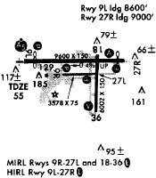
| A81-APT | WHEN ATCT CLSD ACTVT MALSR RWY 9R & 27R; PAPI RWYS 09L, 27R, 09C, 27C, 09R, 27L, 18, & 36; HIRL RWY 09L/27R, 09R/27L; MIRL RWY 18/36 & 9C/27C - CTAF. |
Runways
Runway Summary
| Runways: | 09C/27C 09L/27R 09R/27L 18/36 |
| Longest Runway: | 09L/27R is 11002 ft (3353 m) long |
| Runways with an Instrument Approach: | 09L, 27R, 09R |
SFB Seaplane Base Runway Details
| Runway 09C/27C | 3578 ft x 75 ft (1091 m x 23 m) | |
| Runway Length Source: | 3RD PARTY SURVEY as of 06/01/2024 | |
| Surface: | Asphalt - Fair condition - No special surface treatment | |
| Runway Pavement Class: | 69 /F/A/X/T | |
| Runway Edge Lights: | Medium Intensity | |
Runway Weight Bearing Capacity (in thousands of pounds) |
||
| Single Wheel Landing Gear: | 12.0 | |
Runway 09C |
Runway 27C |
|
Elevation: |
51.5 | 47.6 |
Latitude: |
28-46-42.4335N | 28-46-42.4875N |
Longitude: |
081-14-43.7054W | 081-14-03.5019W |
|
Runway True Alignment: |
090 | 270 |
Glide Path Angle: |
4.0 degrees | 3.0 degrees |
Traffic Pattern: |
Right | |
Runway Markings Type: |
Basic | Basic |
Runway Markings Condition: |
Good | Good |
Object at End: |
TREES | TREES |
Object Height: |
53 | 51 |
Distance from End: |
2020 | 2245 |
Object Centerline Offset: |
65 ft. left of centerline | 125 ft. left of centerline |
Visual Glide Slope Indicators: |
2-Light PAPI On Left Side Of Runway | 2-Light PAPI On Left Side Of Runway |
REIL: |
Yes | No |
Threshold Crossing Height: |
35 | 27 |
Declared Distances |
||
Take Off Run Avbl. (TORA): |
3578 | 3578 |
Take Off Distance Avbl. (TODA): |
3578 | 3578 |
Actual Stop Dist. Avbl. (ASDA): |
3578 | 3578 |
Landing Dist. Avbl. (LDA): |
3578 | 3578 |
| Runway 09L/27R | 11002 ft x 150 ft (3353 m x 46 m) | |
| Runway Length Source: | 3RD PARTY SURVEY as of 06/01/2024 | |
| Surface: | Asphalt - Fair condition - Saw-cut or plastic grooved | |
| Runway Pavement Class: | 67 /F/B/X/T | |
| Runway Edge Lights: | High Intensity | |
Runway Weight Bearing Capacity (in thousands of pounds) |
||
| Single Wheel Landing Gear: | 100.0 | |
| Dual Wheel Landing Gear: | 279.0 | |
| Dual Tandem Wheel Landing Gear: | 840.0 | |
Runway 09L |
Runway 27R |
|
Elevation: |
51.6 | 30.3 |
Latitude: |
28-46-54.2477N | 28-46-54.4399N |
Longitude: |
081-15-21.4372W | 081-13-17.8019W |
|
Runway True Alignment: |
090 | 270 |
ILS Type: |
ILS/DME | ILS/DME |
Glide Path Angle: |
3.0 degrees | 3.0 degrees |
Traffic Pattern: |
Left | Right |
Runway Markings Type: |
Precision Instrument | Precision Instrument |
Runway Markings Condition: |
Good | Good |
Object at End: |
TREES | |
Object Height: |
49 | |
Distance from End: |
1000 | |
Object Centerline Offset: |
65 ft. left of centerline | 125 ft. left of centerline |
Visual Glide Slope Indicators: |
4-Light PAPI On Left Side Of Runway | 4-Light PAPI On Right Side Of Runway |
Approach Light System: |
1,400 Foot Medium Intensity Approach Lighting System With Runway Alignment Indicator Lights | 1,400 Foot Medium Intensity Approach Lighting System With Runway Alignment Indicator Lights |
REIL: |
No | No |
Threshold Crossing Height: |
71 | 72 |
Threshold Elevation: |
54.6 | |
Displaced Threshold: |
1000 | |
Threshold Latitude: |
28-46-54.2683N | |
Threshold Longitude: |
081-15-10.1993W | |
Declared Distances |
||
Take Off Run Avbl. (TORA): |
11002 | 11002 |
Take Off Distance Avbl. (TODA): |
11002 | 11002 |
Actual Stop Dist. Avbl. (ASDA): |
11002 | 11002 |
Landing Dist. Avbl. (LDA): |
10002 | 11002 |
| Runway 09R/27L | 5839 ft x 75 ft (1780 m x 23 m) | |
| Runway Length Source: | 3RD PARTY SURVEY as of 06/01/2024 | |
| Surface: | Asphalt - Fair condition - No special surface treatment | |
| Runway Pavement Class: | 10 /F/C/X/T | |
| Runway Edge Lights: | High Intensity | |
Runway Weight Bearing Capacity (in thousands of pounds) |
||
| Single Wheel Landing Gear: | 67.0 | |
| Dual Wheel Landing Gear: | 80.0 | |
Runway 09R |
Runway 27L |
|
Elevation: |
45.0 | 24.4 |
Latitude: |
28-46-11.8020N | 28-46-11.8941N |
Longitude: |
081-14-01.8110W | 081-12-56.1981W |
|
Runway True Alignment: |
090 | 270 |
ILS Type: |
ILS/DME | |
Glide Path Angle: |
3.0 degrees | 3.0 degrees |
Traffic Pattern: |
Right | |
Runway Markings Type: |
Precision Instrument | Nonprecision Instrument |
Runway Markings Condition: |
Fair | Fair |
Object at End: |
TREES | TREES |
Object Height: |
65 | 37 |
Distance from End: |
3475 | 1875 |
Object Centerline Offset: |
65 ft. left of centerline | 125 ft. left of centerline |
Visual Glide Slope Indicators: |
4-Light PAPI On Left Side Of Runway | 4-Light PAPI On Left Side Of Runway |
Approach Light System: |
1,400 Foot Medium Intensity Approach Lighting System With Runway Alignment Indicator Lights | |
REIL: |
No | Yes |
Threshold Crossing Height: |
44 | 47 |
Threshold Elevation: |
39.2 | |
Displaced Threshold: |
839 | |
Threshold Latitude: |
28-46-11.8156N | |
Threshold Longitude: |
081-13-52.3799W | |
Declared Distances |
||
Take Off Run Avbl. (TORA): |
5839 | 5839 |
Take Off Distance Avbl. (TODA): |
5839 | 5839 |
Actual Stop Dist. Avbl. (ASDA): |
5839 | 5839 |
Landing Dist. Avbl. (LDA): |
5000 | 5839 |
| Runway 18/36 | 6002 ft x 150 ft (1829 m x 46 m) | |
| Runway Length Source: | 3RD PARTY SURVEY as of 06/01/2024 | |
| Surface: | Asphalt - Fair condition - Saw-cut or plastic grooved | |
| Runway Pavement Class: | 23 /F/C/X/T | |
| Runway Edge Lights: | Medium Intensity | |
Runway Weight Bearing Capacity (in thousands of pounds) |
||
| Single Wheel Landing Gear: | 111.0 | |
| Dual Wheel Landing Gear: | 183.0 | |
| Dual Tandem Wheel Landing Gear: | 599.0 | |
Runway 18 |
Runway 36 |
|
Elevation: |
48.3 | 43.0 |
Latitude: |
28-46-59.8260N | 28-46-00.4033N |
Longitude: |
081-14-05.2341W | 081-14-05.1007W |
|
Runway True Alignment: |
180 | 360 |
Glide Path Angle: |
3.0 degrees | 3.0 degrees |
Traffic Pattern: |
Left | Right |
Runway Markings Type: |
Nonprecision Instrument | Nonprecision Instrument |
Runway Markings Condition: |
Good | Good |
Object at End: |
TREES | TREES |
Object Height: |
35 | 32 |
Distance from End: |
1450 | 1005 |
Object Centerline Offset: |
65 ft. left of centerline | 125 ft. left of centerline |
Visual Glide Slope Indicators: |
4-Light PAPI On Left Side Of Runway | 4-Light PAPI On Left Side Of Runway |
REIL: |
Yes | Yes |
Threshold Crossing Height: |
48 | 45 |
Declared Distances |
||
Take Off Run Avbl. (TORA): |
6002 | 6002 |
Take Off Distance Avbl. (TODA): |
6002 | 6002 |
Actual Stop Dist. Avbl. (ASDA): |
5956 | 6002 |
Landing Dist. Avbl. (LDA): |
5956 | 6002 |
Services
Airframe Repair: |
Minor |
Powerplant Repair: |
Minor |
Bottled Oxygen: |
None |
Bulk Oxygen: |
None |
Fuel Available: |
100LL |
Landing Fees: |
No |
Parking: |
Hangars and tiedowns available |
Maps & Diagrams
SFB Sectional
Flight Planning
at skyvector.com
at skyvector.com