Location
Latitude: |
39-07-22.5680N (39.122936) |
Longitude: |
094-35-34.1630W (-94.592823) |
Elevation: |
756.8 feet MSL (231 m MSL) |
Magnetic Variation: |
1.2 E (as of April 2024 from WMM2020 model) |
Time Zone: |
UTC -6.0 (Standard Time) UTC -5.0 (Daylight Savings Time) |
From City: |
00 N.M. NW of Kansas City, Missouri |
Found On: |
Kansas City Chart |
FAA Region: |
ACE |
Contacts
Manager: |
Publicly owned: |
| ADAM FREEMAN, C.M. 900 RICHARDS ROAD KANSAS CITY, MO 64116 (816) 859-7610 |
CITY OF KANSAS CITY 414 E. 12TH ST KANSAS CITY, MO 64106 816-859-7601 |
Operations
Airport Status: |
Operational |
Facility Use: |
Public |
Type: |
Airport |
Activation Date: |
04/1940 |
Control tower: |
Yes |
Attendance (Months/Days/Hours): |
Months/Days/Hours ALL/ALL/ALL |
Boundary ARTCC: |
ZKC (Kansas City) |
Responsible ARTCC: |
ZKC (Kansas City) |
Lighting Schedule: |
SS-SR |
Segmented Circle Indicator: |
No |
Traffic Pattern Altitude (MSL): |
1757 feet (536 m) |
NOTAMs Facility: |
MKC |
NOTAM-D Service: |
Yes |
International Airport of Entry: |
No |
Customs Landing Rights: |
Yes |
Military Landing Rights: |
Yes |
Civil/Military Joint Use: |
No |
Aircraft Rescue and Firefighting: |
Class IV ARFF Index: A Air Carrier Service: Not Scheduled Certification Date: 06/1995 |
Based Aircraft
| Single Engine: | 76 |
| Multi Engine: | 21 |
| Jet Engine: | 81 |
| GA Helicopters: | 12 |
Annual Operations (as of 09/30/2023)
| Total Operations: | 124214 | |
| Commercial: | 496 | 0.4% |
| Air Taxi: | 30584 | 24.6% |
| GA Local: | 38543 | 31.0% |
| GA Itinerant: | 53529 | 43.1% |
| Military Aircraft: | 1062 | 0.9% |
Communications
| Unicom: | 122.950 |
| Tower: | DOWNTOWN 133.3 233.7 Hrs: 24 |
| Ground: | 121.9 |
| Approach: | KANSAS CITY |
| Departure: | KANSAS CITY |
| ATIS: | 120.75 Hrs: 24 |
| ASOS: | 120.75 (816-329-2843) |
- INTERFERENCE FROM FM RADIO STATION MAY AFFECT COMMUNICATIONS IN THE IMMEDIATE VICINITY OF THE ARPT.
Fixed Based Operators (FBOs) & Fuel
(Click on a business for detail)
Please help us keep this information up to date. This is a FREE SERVICE just like everything else on Airport Guide! If you see that a business needs to be added, modified, or deleted please fill out our Update Form.
To add, modify, or delete a business click here.
Please help us keep this information up to date. This is a FREE SERVICE just like everything else on Airport Guide! If you see that a business needs to be added, modified, or deleted please fill out our Update Form.
Area Code: 816 |
| Business Name | Frequency | Phone | Fuel Grade |
|---|---|---|---|
| Executive Beechcraft, Inc.
Update FBO info |
Unicom 122.95 | 842-8484 | 100LL, Jet A |
| Hunter Price Aviation
Update FBO info |
Arinc 129.275 | 842-3313 | 100LL, Jet A |
| Kansas City Helicopter, LLC
Update FBO info |
221-6854 | ||
| Signature Flight Support
Update FBO info |
Unicom: 122.95, Arinc: 129.575 | +1 816 842 8484 | |
| Spirit Aviation, Inc.
Update FBO info |
221-3192 | ||
| The Aero Centre
Update FBO info |
Unicom 122.95 | 221-6677 | 100LL, Jet A |
Flight Service Stations
| Primary | Alternate | |
| FSS on Field: | N | |
| FSS Name (ID): | Columbia(COU) | |
| Frequency: | ||
| Toll Free Phone: | 1-800-WX-BRIEF |
Instrument Procedures / Charts
FAA Terminal Procedures valid from 0901Z 03/21/24 to 0901Z 04/18/24.
There are various types of charts available for an airport. They are listed in the Page Type column. Here is a legend for those types:
APD - Airport Diagram
DP - Departure Procedure Charts
HOT - Hot Spots
IAP - Instrument Approach Procedure Charts
MIN - Minimums
STAR - Standard Terminal Arrival Charts
| Page Type | Page Name | Volume | Action Since Last Cycle |
|---|---|---|---|
| APD | AIRPORT DIAGRAM | NC-3 | Changed |
| DP | CHIEF NINE | NC-3 | |
| DP | LAKES FIVE | NC-3 | |
| DP | RACER EIGHT | NC-3 | |
| DP | ROYAL ONE | NC-3 | |
| DP | TIFTO EIGHT | NC-3 | |
| DP | WILDCAT SIX | NC-3 | |
| HOT | HOT SPOT | NC-3 | Changed |
| IAP | ILS OR LOC RWY 04 | NC-3 | Changed |
| IAP | ILS OR LOC RWY 19 | NC-3 | Changed |
| IAP | RNAV (GPS) RWY 04 | NC-3 | Changed |
| IAP | RNAV (GPS) RWY 22 | NC-3 | Changed |
| IAP | RNAV (GPS) Y RWY 19 | NC-3 | Changed |
| IAP | RNAV (GPS) Z RWY 19 | NC-3 | Changed |
| MIN | ALTERNATE MINIMUMS | NC-3 | |
| MIN | TAKEOFF MINIMUMS | NC-3 | |
| STAR | BRAYMER EIGHT | NC-3 | |
| STAR | BRAYMER EIGHT[DELIMITER] CONT.1 | NC-3 | |
| STAR | JHAWK SEVEN | NC-3 | |
| STAR | TYGER SEVEN | NC-3 | |
| STAR | TYGER SEVEN[DELIMITER] CONT.1 | NC-3 |
Terminal Procedures are only available for airports in several countries with more being added all the time. If you are looking for a specific country's charts, please send an email to support(at)airportguide.com stating the country name. This will be used to prioritize the implementation.
Navigation Aids (Navaids) near MKC
| Dist (NM) | ID | Morse Code | Name | Type | Freq | True Hdg | Mag Hdg |
|---|---|---|---|---|---|---|---|
| 0.2 | RIS | . _ . . . . . . | Riverside | VOR-DME | 111.40 | 229 | 228 |
| 0.2 | MKC | _ _ _ . _ _ . _ . | Kansas City Downtown | VOT | 108.60 | 273 | 272 |
| 4.7 | GQ | _ _ . _ _ . _ | Norge | NDB | 517 | 218 | 217 |
| 9.4 | DO | _ . . _ _ _ | Dotte | NDB | 359 | 308 | 307 |
| 11.8 | MCI | _ _ _ . _ . . . | Kansas City | VORTAC | 113.25 | 325 | 324 |
| 18.2 | OJC | _ _ _ . _ _ _ _ . _ . | Johnson County | VOR-DME | 113.00 | 201 | 200 |
| 21.7 | ANX | . _ _ . _ . . _ | Napoleon | VORTAC | 114.00 | 94 | 93 |
| 23.2 | PK | . _ _ . _ . _ | Herbb | NDB | 420 | 196 | 195 |
| 29.0 | JZ | . _ _ _ _ _ . . | Newbn | NDB | 338 | 244 | 243 |
| 36.2 | ST | . . . _ | Tario | NDB | 260 | 336 | 335 |
| 44.5 | TOP | _ _ _ _ . _ _ . | Topeka | VORTAC | 117.80 | 271 | 269 |
| 45.1 | BQS | _ . . . _ _ . _ . . . | Braymer | VOR-DME | 115.35 | 47 | 46 |
| 47.9 | AZN | . _ _ _ . . _ . | Amazon | NDB | 233 | 342 | 341 |
| 48.3 | FO | . . _ . _ _ _ | Riply | NDB | 326 | 253 | 251 |
| 50.9 | FOE | . . _ . _ _ _ . | Forbes | TACAN | 111.60 | 258 | 256 |
| 50.9 | TO | _ _ _ _ | Biloy | NDB | 521 | 270 | 268 |
| 51.1 | FOE | . . _ . _ _ _ . | Forbes | VOT | 111.00 | 258 | 256 |
| 51.3 | BUM | _ . . . . . _ _ _ | Butler | VORTAC | 115.90 | 174 | 173 |
| 52.6 | STJ | . . . _ . _ _ _ | St Joseph | VORTAC | 115.50 | 343 | 342 |
| 53.9 | SZL | . . . _ _ . . . _ . . | Whiteman | TACAN | 109.80 | 115 | 114 |
Nearby Airports with Fuel
Notices to Airmen (NOTAMS)
Remarks
| A110-10 | FLOCKS OF PIGEONS INVOF DEP EOR 04. |
| A110-12 | RWY 04/22 VFR E TFC PAT: DEPARTING RWY 04 RIGHT TFC ATTAIN TFC PAT ALT PRIOR TO TURNING CROSSWIND. LDG RWY 22 MNTN TFC PAT ALT UNTIL PASSING N OF MISSOURI RIVER. |
| A110-14 | ATCT HAS LIMITED VISIBILITY OF T-HANGAR APRONS N TWY D AND W TWY L . |
| A110-15 | FAA SAFETY VIDEO CAN BE ACCESSED AT HTTPS://WWW.FAA.GOV/AIRPORTS/RUNWAY_SAFETY/VIDEOS/MKC/ |
| A110-16 | CTN: MULT OBSTRUCTIONS 0.5 MI-1.0 MI ESE FM RWY 19 DER UP TO 290 FT AGL/1100 FT MSL. |
| A110-17 | DUE TO OBSTNS, PRIOR TO ANY TURNS TO THE E, ACFT MUST BE AT OR ABV TFC PTN ALT |
| A110-6 | WILDLIFE ON & INVOF ARPT. |
| A26 | ARPT CLSD TO ACR OPNS WITH MORE THAN 30 PSGR SEATS EXCP 24 HR PPR CALL AMGR (816) 289-2718. AIR CARRIER OPS NOT AUTHORIZED IN EXCESS OF 15 MINUTES BFR OR AFT SKED ARR OR DEP TIMES W/O PRIOR COORDINATION WITH AMGR CONFIRMING ARFF AVBL PRIOR TO LNDG OR TKOF. |
| A43-22 | UNUSBL BYD 8 DEGS LEFT OF CRS. |
| A49-19 | RY19 MALSF AUGMENTED WITH RAIL. |
| A57-04 | APCH RATIO AT DSPLCD THR 47:1. |
| A57-22 | APCH RATIO AT DSPLCD THR 24:1. |
| A58-19 | ROAD & FENCE 0-200' FM THR. |
| A58-22 | ROAD & RR 0-200' FM THR. |
| A70-FUEL-10 | 0LL 100LL SELF SVC AVBL 24 HRS WITH CREDIT CARD ONLY ON WEST SIDE NEAR GA TERMINAL. |
| E60-01 | ENGINEERED MATERIALS ARRESTING SYSYTEM (EMAS) 263 FT IN LENGTH BY 170 FT IN WIDTH LCTD AT THE DER 01. |
| E60-19 | ENGINEERED MATERIALS ARRESTING SYSYTEM (EMAS) 287 FT IN LENGTH BY 170 FT IN WIDTH LCTD AT THE DER 19. |
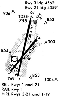
Runways
Runway Summary
| Runways: | 01/19 04/22 |
| Longest Runway: | 01/19 is 6827 ft (2081 m) long |
| Runways with an Instrument Approach: | 19, 04 |
MKC Airport Runway Details
| Runway 01/19 | 6827 ft x 150 ft (2081 m x 46 m) | |
| Runway Length Source: | 3RD PARTY SURVEY as of 11/08/2011 | |
| Surface: | Concrete - Excellent condition - Saw-cut or plastic grooved | |
| Runway Pavement Class: | 67 /R/B/W/T | |
| Runway Edge Lights: | High Intensity | |
Runway Weight Bearing Capacity (in thousands of pounds) |
||
| Single Wheel Landing Gear: | 86.0 | |
| Dual Wheel Landing Gear: | 171.0 | |
| Dual Tandem Wheel Landing Gear: | 342.0 | |
Runway 01 |
Runway 19 |
|
Elevation: |
748.5 | 756.8 |
Latitude: |
39-06-52.8788N | 39-07-58.7018N |
Longitude: |
094-35-43.2503W | 094-35-24.2269W |
|
Runway True Alignment: |
013 | 193 |
ILS Type: |
ILS/DME | |
Glide Path Angle: |
3.7 degrees | 3.0 degrees |
Traffic Pattern: |
Left | |
Runway Markings Type: |
Nonprecision Instrument | Precision Instrument |
Runway Markings Condition: |
Good | Good |
Arresting Device: |
EMAS | EMAS |
Object at End: |
TREE | ROAD |
Object Height: |
38 | 20 |
Distance from End: |
747 | 700 |
Object Centerline Offset: |
571 ft. right of centerline | 150 ft. left of centerline |
Visual Glide Slope Indicators: |
4-Box VASI On Left Side Of Runway | 4-Light PAPI On Left Side Of Runway |
Runway Visual Range (RVR): |
Rollout | Touchdown |
Approach Light System: |
1,400 Foot Medium Intensity Approach Lighting System With Sequenced Flashers | |
REIL: |
Yes | No |
Threshold Crossing Height: |
66 | 46 |
Threshold Elevation: |
746.4 | 754.4 |
Displaced Threshold: |
299 | 302 |
Threshold Latitude: |
39-06-55.7662N | 39-07-55.7933N |
Threshold Longitude: |
094-35-42.4177W | 094-35-25.0689W |
Declared Distances |
||
Take Off Run Avbl. (TORA): |
6827 | 6827 |
Take Off Distance Avbl. (TODA): |
6827 | 6827 |
Actual Stop Dist. Avbl. (ASDA): |
6827 | 6827 |
Landing Dist. Avbl. (LDA): |
6527 | 6525 |
| Runway 04/22 | 5050 ft x 100 ft (1539 m x 30 m) | |
| Runway Length Source: | 3RD PARTY SURVEY as of 12/08/2022 | |
| Surface: | Concrete - Excellent condition - No special surface treatment | |
| Runway Pavement Class: | 74 /F/C/W/T | |
| Runway Edge Lights: | High Intensity | |
Runway Weight Bearing Capacity (in thousands of pounds) |
||
| Single Wheel Landing Gear: | 48.0 | |
| Dual Wheel Landing Gear: | 73.0 | |
| Dual Tandem Wheel Landing Gear: | 136.0 | |
Runway 04 |
Runway 22 |
|
Elevation: |
742.3 | 742.9 |
Latitude: |
39-06-58.6622N | 39-07-37.7603N |
Longitude: |
094-35-54.6460W | 094-35-14.8211W |
|
Runway True Alignment: |
038 | 218 |
ILS Type: |
ILS/DME | |
Glide Path Angle: |
3.0 degrees | 3.3 degrees |
Traffic Pattern: |
Left | Left |
Runway Markings Type: |
Precision Instrument | Nonprecision Instrument |
Runway Markings Condition: |
Good | Good |
Object at End: |
BERM | RR |
Object Height: |
20 | 37 |
Object Marked/Lighted?: |
Lighted | Lighted |
Distance from End: |
450 | 225 |
Object Centerline Offset: |
571 ft. right of centerline | 150 ft. left of centerline |
Visual Glide Slope Indicators: |
4-Box VASI On Left Side Of Runway | 4-Box VASI On Left Side Of Runway |
Runway Visual Range (RVR): |
Touchdown | Rollout |
REIL: |
Yes | |
Threshold Crossing Height: |
35 | 35 |
Threshold Elevation: |
742.6 | 743.4 |
Displaced Threshold: |
500 | 699 |
Threshold Latitude: |
39-07-02.5362N | 39-07-32.3482N |
Threshold Longitude: |
094-35-50.7013W | 094-35-20.3341W |
Declared Distances |
||
Take Off Run Avbl. (TORA): |
5050 | 5050 |
Take Off Distance Avbl. (TODA): |
5050 | 5050 |
Actual Stop Dist. Avbl. (ASDA): |
4770 | 5050 |
Landing Dist. Avbl. (LDA): |
4270 | 4351 |
Services
Airframe Repair: |
Minor |
Powerplant Repair: |
Minor |
Bottled Oxygen: |
None |
Bulk Oxygen: |
None |
Fuel Available: |
100LL, Jet A |
Landing Fees: |
No |
Parking: |
Tiedowns available |
Maps & Diagrams
MKC Sectional
Flight Planning
at skyvector.com
at skyvector.com