Location
Latitude: |
32-18-02.3000N (32.300639) |
Longitude: |
086-23-38.3000W (-86.393972) |
Elevation: |
221.1 feet MSL (67 m MSL) |
Magnetic Variation: |
4 W (as of April 2024 from WMM2020 model) |
Time Zone: |
UTC -6.0 (Standard Time) UTC -5.0 (Daylight Savings Time) |
From City: |
06 N.M. SW of Montgomery, Alabama |
Found On: |
Atlanta Chart |
FAA Region: |
ASO |
Contacts
Manager: |
Publicly owned: |
| WADE DAVIS C.M. 4445 SELMA HWY MONTGOMERY, AL 36108 334-281-5040 |
MONTGOMERY AIRPORT AUTHORITY 4445 SELMA HWY MONTGOMERY, AL 36108 334-281-5040 |
Operations
Airport Status: |
Operational |
Facility Use: |
Public |
Type: |
Airport |
Activation Date: |
06/1987 |
Control tower: |
Yes |
Attendance (Months/Days/Hours): |
Months/Days/Hours ALL/ALL/ALL |
Boundary ARTCC: |
ZTL (Atlanta) |
Responsible ARTCC: |
ZTL (Atlanta) |
Lighting Schedule: |
SEE RMK |
Segmented Circle Indicator: |
Yes |
Traffic Pattern Altitude (MSL): |
1221 feet (372 m) |
NOTAMs Facility: |
MGM |
NOTAM-D Service: |
Yes |
International Airport of Entry: |
No |
Customs Landing Rights: |
No |
Military Landing Rights: |
Yes |
Civil/Military Joint Use: |
No |
Aircraft Rescue and Firefighting: |
Class I ARFF Index: B Air Carrier Service: Scheduled Certification Date: 05/1973 |
Based Aircraft
| Single Engine: | 51 |
| Multi Engine: | 15 |
| Jet Engine: | 6 |
| GA Helicopters: | 6 |
| Military Aircraft: | 32 |
Annual Operations (as of 10/31/2023)
| Total Operations: | 52228 | |
| Commercial: | 4216 | 8.1% |
| Air Taxi: | 4590 | 8.8% |
| GA Local: | 14023 | 26.8% |
| GA Itinerant: | 17854 | 34.2% |
| Military Aircraft: | 11545 | 22.1% |
Communications
| CTAF: | 119.700 |
| Unicom: | 122.950 |
| Tower: | DANNELLY 119.7 360.85 Hrs: 0600-2300 |
| Clearance Del.: | 118.3 270.3 |
| Ground: | 121.7 348.6 |
| Approach: | MONTGOMERY 124.0 363.025 Hrs: 0600-2300 ATLANTA ARTCC 112.1T 118.85 ;NORTH 132.45 ;SOUTH 255.6 ;NORTH 322.5 ;SOUTH Hrs: 2300-0600. |
| Departure: | MONTGOMERY 124.0 363.025 Hrs: 0600-2300 ATLANTA ARTCC 112.1T 118.85 ;NORTH 132.45 ;SOUTH 255.6 ;NORTH 322.5 ;SOUTH Hrs: 2300-0600. |
| ATIS: | 120.675 Hrs: 24 |
| ASOS: | (334-288-0445) |
| TRSA: | 124.0 |
| EMERG: | 243.0 |
| ANG OPS: | 360.975 |
| TRSA: | 363.025 |
| EMERG: | 121.5 |
| SFA: | 284.0 |
| ANG OPS: | 40.3FM |
| ANG OPS: | 286.5 |
| SFA: | 122.85 |
| SFA: | 307.075 |
- APCH/DEP SVC PRVDD BY ATLANTA ARTCC ON FREQS 120.55/270.25 (MONTGOMERY RCAG) WHEN APCH CTL CLSD.
- SECTORIZATION BASED ON MONTGOMERY VORTAC.
- ARNG OPS 38.2 149.775 226.35 (PRIMARY).
Fixed Based Operators (FBOs) & Fuel
(Click on a business for detail)
Please help us keep this information up to date. This is a FREE SERVICE just like everything else on Airport Guide! If you see that a business needs to be added, modified, or deleted please fill out our Update Form.
To add, modify, or delete a business click here.
Please help us keep this information up to date. This is a FREE SERVICE just like everything else on Airport Guide! If you see that a business needs to be added, modified, or deleted please fill out our Update Form.
Area Code: 334 |
| Business Name | Frequency | Phone | Fuel Grade |
|---|---|---|---|
| K-C Aviation
Update FBO info |
Unicom 122.95 | 288-6081 | |
| Montgomery Aviation Corp.
Update FBO info |
Unicom 122.95 | 288-7334 | 100LL, Jet A |
Flight Service Stations
| Primary | Alternate | |
| FSS on Field: | N | |
| FSS Name (ID): | Anniston(ANB) | |
| Frequency: | ||
| Toll Free Phone: | 1-800-WX-BRIEF |
Instrument Procedures / Charts
FAA Terminal Procedures valid from 0901Z 03/21/24 to 0901Z 04/18/24.
There are various types of charts available for an airport. They are listed in the Page Type column. Here is a legend for those types:
APD - Airport Diagram
DP - Departure Procedure Charts
HOT - Hot Spots
IAP - Instrument Approach Procedure Charts
MIN - Minimums
STAR - Standard Terminal Arrival Charts
| Page Type | Page Name | Volume | Action Since Last Cycle |
|---|---|---|---|
| APD | AIRPORT DIAGRAM | SE-4 | |
| HOT | HOT SPOT | SE-4 | |
| IAP | HI-ILS Y OR LOC Y RWY 10 | SE-4 | |
| IAP | HI-TACAN-J | SE-4 | |
| IAP | ILS Y OR LOC RWY 28 | SE-4 | |
| IAP | ILS Z OR LOC Z RWY 10 | SE-4 | |
| IAP | ILS Z RWY 28 | SE-4 | |
| IAP | NDB RWY 10 | SE-4 | |
| IAP | RNAV (GPS) RWY 03 | SE-4 | |
| IAP | RNAV (GPS) RWY 10 | SE-4 | |
| IAP | RNAV (GPS) RWY 28 | SE-4 | |
| IAP | VOR-A | SE-4 | |
| MIN | ALTERNATE MINIMUMS | SE-4 | |
| MIN | RADAR MINIMUMS | SE-4 | |
| MIN | TAKEOFF MINIMUMS | SE-4 |
Terminal Procedures are only available for airports in several countries with more being added all the time. If you are looking for a specific country's charts, please send an email to support(at)airportguide.com stating the country name. This will be used to prioritize the implementation.
Navigation Aids (Navaids) near MGM
| Dist (NM) | ID | Morse Code | Name | Type | Freq | True Hdg | Mag Hdg |
|---|---|---|---|---|---|---|---|
| 4.9 | MXF | _ _ _ . . _ . . _ . | Maxwell | TACAN | 115.00 | 15 | 19 |
| 6.0 | MG | _ _ _ _ . | Marra | NDB | 245 | 276 | 280 |
| 6.0 | MGM | _ _ _ _ . _ _ | Montgomery | VORTAC | 112.10 | 141 | 145 |
| 27.1 | SE | . . . . | Pollk | NDB | 344 | 266 | 270 |
| 30.4 | JYU | . _ _ _ _ . _ _ . . _ | Junior | VOR-DME | 113.60 | 275 | 279 |
| 31.8 | TOI | _ _ _ _ . . | Blood | NDB | 365 | 152 | 156 |
| 34.9 | GGY | _ _ . _ _ . _ . _ _ | Gragg-Wade | NDB | 338 | 341 | 345 |
| 38.3 | TGE | _ _ _ . . | Tuskegee | VOR-DME | 117.30 | 73 | 77 |
| 41.0 | DER | _ . . . . _ . | Alexander City | NDB | 382 | 32 | 36 |
| 52.6 | SCD | . . . _ . _ . _ . . | Sylacauga | NDB | 284 | 4 | 8 |
| 59.7 | JUY | . _ _ _ . . _ _ . _ _ | Judd | NDB | 264 | 179 | 183 |
| 61.4 | BVG | _ . . . . . . _ _ _ . | Boll Weevil | NDB | 352 | 159 | 163 |
| 65.3 | EDN | . _ . . _ . | Enterprise | VOR | 116.60 | 157 | 161 |
| 65.4 | LOR | . _ . . _ _ _ . _ . | Lowe | NDB | 269 | 149 | 153 |
| 67.1 | HYE | . . . . _ . _ _ . | Hanchey | NDB | 221 | 145 | 149 |
| 67.2 | HEY | . . . . . _ . _ _ | Hanchey | VOR | 110.60 | 145 | 149 |
| 67.6 | EUF | . . . _ . . _ . | Eufaula | VORTAC | 109.20 | 107 | 111 |
| 69.1 | CS | _ . _ . . . . | Fenix | NDB | 355 | 82 | 86 |
| 69.5 | AWS | . _ . _ _ . . . | Lawson | NDB | 335 | 90 | 94 |
| 70.2 | MVC | _ _ . . . _ _ . _ . | Monroeville | VORTAC | 116.80 | 224 | 228 |
Nearby Airports with Fuel
Notices to Airmen (NOTAMS)
Remarks
| A110-1 | NO 180 DEG TURNS ON RWY 10/28 BY DC-9 OR LARGER ACFT. |
| A110-10 | ACR & LRG MIL ACFT SHOULD NOT TAXI ON RWY 03/21. |
| A110-14 | MILITARY: BIRD HAZARD. CTC BASE OPS ON 360.975 FOR CURRENT BIRD WATCH COND. BASH PHASE II BIRD ACT IS DURG APR AND FM 1 SEP TO 31 DEC. |
| A110-15 | ARNG - F/W ACFT INBD TO ARNG RAMP CTC ARNG 10MIN PRIOR TO ETA AND UPON ENTY TWY D. L-3 (C-12)MAINT AVBL ON CALL, C334-280-4890 COMMUNICATIONS. |
| A110-16 | MILITARY: ANG: ONGOING CONSTR ON RAMP. CTC BASE OPS FOR TAX/PRKG INSTRNS DSN 358-9255 OR C334-394-7255. |
| A110-18 | ANG: RWY CC NOT RPT. |
| A110-19 | FOR CD IF UNA TO CTC ON FSS FREQ, CTC DANNELLY APCH AT 334-284-4575, WHEN ATCT CLSD CTC ATLANTA ARTCC AT 770-210-7692. |
| A110-20 | MILITARY: FLUID: LHNIT. |
| A110-21 | MILITARY: OIL: JOAP. |
| A110-6 | CAUTION: DO NOT MISTAKE MAXWELL AFB - 6 NM NORTH FOR MONGOMERY RGNL. NUMEROUS HEL AND LOW SPEED ACFT INVOF ARPT DURG DALGT HRS. |
| A110-8 | ARNG: ANG RAMP CONST WIP. CTC AFLD MGMT FOR TAXI INSTR. TRANSPORT ACFT LTD TO MIN THRUST WHILE ON ANG RAMP. CONES BLOCKING THROAT OF ANG RAMP. CTC BASE OPS PRIOR TO ENTERING ANG RAMP FOR REMOVAL. INBD FOR ANG CTC BAMA OPS 15 MIN PRIOR LDG. ACFT PARKING EXTREMELY LMTD CTC BASE OPNS FOR PARKING INSTR. TSNT PARKING EXTREMELY LIMITED. PPR FOR USE OF ANG RAMP CTC ANG OPNS DSN358-9255/9256/C334-394-7255/7256. ANG BASE OPS FACILITY AVBL 1200-2230Z++. |
| A26 | CLSD TO UNSKED ACR OPNS & LRG MIL ACFT REQUIRING PARKING, EXCP WITH 72 HRS PPR CTC AMGR 334-281-5040. |
| A30-03/21 | RWY 3/21 NOT AVBL FOR SKED ACR OPNS WITH MORE THAN 9 PSGR SEATS OR UNSKED ACR AT LEAST 31 PSGR SEATS. |
| A30-10/28 | MILITARY: RWY 10 AND RWY 28 BAK-12B(B) AVBL WITH 30 MIN PN 1200-0500Z++. 8 PT TIE-DOWNS ON BAK-12B(B). RAISED CABLE ON ATIS BCST. |
| A38-10/28 | DC-10-10 320; DC-10-30 & 40 400; L1011 350; B747 500. |
| A70-FUEL-A | SERVICE-FUEL: ( A++100 (MIL)). |
| A74 | UP TO 2200 PSI. |
| A81-APT | WHEN ATCT CLSD HIRL RWY 10/28 PRESET MED INTST, MIRL RWY 03/21 PRESET LOW INTST. PAPI RWYS 03, 21, 10, & 28 OPR CONSLY. ACTVT MALSR RWYS 10 & 28; REIL RWY 03 - CTAF. |
| E115 | ALABAMA ANG ONLY. |
| E147 | TPA: 1200 FT AGL CONV ACFT, 1700 FT AGL JET ACFT. |
| E60-10 | HOOK BAK-12B(B) (1500 FT). |
| E60-28 | HOOK BAK-12B(B) (1510 FT). |
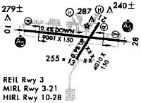
Runways
Runway Summary
| Runways: | 03/21 10/28 |
| Longest Runway: | 10/28 is 9020 ft (2749 m) long |
| Runways with an Instrument Approach: | 10, 28 |
MGM Airport Runway Details
| Runway 03/21 | 4011 ft x 150 ft (1223 m x 46 m) | |
| Runway Length Source: | 3RD PARTY SURVEY as of 06/23/2011 | |
| Surface: | Asphalt - Fair condition - No special surface treatment | |
| Runway Pavement Class: | 28 /F/C/X/T | |
| Runway Edge Lights: | Medium Intensity | |
Runway Weight Bearing Capacity (in thousands of pounds) |
||
| Single Wheel Landing Gear: | 40.0 | |
| Dual Wheel Landing Gear: | 95.0 | |
Runway 03 |
Runway 21 |
|
Elevation: |
221.1 | 186.5 |
Latitude: |
32-17-41.9700N | 32-18-15.2664N |
Longitude: |
086-23-38.9011W | 086-23-13.4683W |
|
Runway True Alignment: |
033 | 213 |
Glide Path Angle: |
3.0 degrees | 3.0 degrees |
Traffic Pattern: |
Left | Left |
Runway Markings Type: |
Nonprecision Instrument | Nonprecision Instrument |
Runway Markings Condition: |
Good | Good |
Object at End: |
FENCE | TREE |
Object Height: |
22 | 54 |
Distance from End: |
700 | 1300 |
Object Centerline Offset: |
0 ft. left and right of centerline | 300 ft. left of centerline |
Visual Glide Slope Indicators: |
4-Light PAPI On Left Side Of Runway | 4-Light PAPI On Left Side Of Runway |
REIL: |
Yes | |
Threshold Crossing Height: |
43 | 55 |
| Runway 10/28 | 9020 ft x 150 ft (2749 m x 46 m) | |
| Runway Length Source: | 3RD PARTY SURVEY as of 06/23/2011 | |
| Surface: | Asphalt - Fair condition - Saw-cut or plastic grooved | |
| Runway Pavement Class: | 35 /F/C/X/T | |
| Runway Edge Lights: | High Intensity | |
Runway Weight Bearing Capacity (in thousands of pounds) |
||
| Single Wheel Landing Gear: | 105.0 | |
| Dual Wheel Landing Gear: | 116.0 | |
| Dual Tandem Wheel Landing Gear: | 180.0 | |
Runway 10 |
Runway 28 |
|
Elevation: |
219.3 | 195.5 |
Latitude: |
32-18-08.6362N | 32-17-59.2946N |
Longitude: |
086-24-35.9779W | 086-22-51.4655W |
|
Runway True Alignment: |
096 | 276 |
ILS Type: |
ILS | ILS |
Glide Path Angle: |
3.0 degrees | 3.0 degrees |
Traffic Pattern: |
Right | Left |
Runway Markings Type: |
Precision Instrument | Precision Instrument |
Runway Markings Condition: |
Good | Good |
Arresting Device: |
BAK-12B | BAK-12B |
Object at End: |
TREE | TREE |
Object Height: |
35 | 65 |
Distance from End: |
1990 | 2800 |
Object Centerline Offset: |
0 ft. left and right of centerline | 300 ft. left of centerline |
Visual Glide Slope Indicators: |
4-Light PAPI On Right Side Of Runway | 4-Light PAPI On Left Side Of Runway |
Runway Visual Range (RVR): |
Touchdown | Rollout |
Approach Light System: |
1,400 Foot Medium Intensity Approach Lighting System With Runway Alignment Indicator Lights | 1,400 Foot Medium Intensity Approach Lighting System With Runway Alignment Indicator Lights |
Threshold Crossing Height: |
64 | 75 |
Services
Airframe Repair: |
Major |
Powerplant Repair: |
Major |
Bottled Oxygen: |
None |
Bulk Oxygen: |
None |
Fuel Available: |
100LL, Jet A+ |
Landing Fees: |
No |
Parking: |
Tiedowns available |
Maps & Diagrams
MGM Sectional
Flight Planning
at skyvector.com
at skyvector.com