Location
Latitude: |
37-49-42.4000N (37.828444) |
Longitude: |
121-37-33.0000W (-121.625833) |
Elevation: |
78.5 feet MSL (24 m MSL) |
Magnetic Variation: |
12.9 E (as of April 2024 from WMM2020 model) |
Time Zone: |
UTC -8.0 (Standard Time) UTC -7.0 (Daylight Savings Time) |
From City: |
02 N.M. S of Byron, California |
Found On: |
San Francisco Chart |
FAA Region: |
AWP |
Contacts
Manager: |
Publicly owned: |
| GREG BAER 550 SALLY RIDE DR CONCORD, CA 94250 925-681-4200 |
CONTRA COSTA COUNTY 550 SALLY RIDE DR CONCORD, CA 94520 925-681-4200 |
Operations
Airport Status: |
Operational |
Facility Use: |
Public |
Type: |
Airport |
Activation Date: |
11/1994 |
Control tower: |
No |
Attendance (Months/Days/Hours): |
Months/Days/Hours ALL/ALL/0700-1400 |
Boundary ARTCC: |
ZOA (Oakland) |
Responsible ARTCC: |
ZOA (Oakland) |
Lighting Schedule: |
SEE RMK |
Segmented Circle Indicator: |
Yes |
Traffic Pattern Altitude (MSL): |
1078 feet (329 m) |
NOTAMs Facility: |
OAK |
NOTAM-D Service: |
Yes |
Based Aircraft
| Single Engine: | 66 |
| Multi Engine: | 4 |
| GA Helicopters: | 1 |
| Gliders: | 12 |
| Ultralights: | 1 |
Annual Operations (as of 12/31/2021)
| Total Operations: | 83075 | |
| GA Local: | 65000 | 78.2% |
| GA Itinerant: | 18000 | 21.7% |
| Military Aircraft: | 75 | 0.1% |
Communications
| CTAF: | 123.050 |
| Unicom: | 123.050 |
| Approach: | NORCAL 123.85 123.85 |
| Departure: | NORCAL 123.85 123.85 |
| AWOS-3: | 123.775 (925-634-0906) |
Fixed Based Operators (FBOs) & Fuel
(Click on a business for detail)
Please help us keep this information up to date. This is a FREE SERVICE just like everything else on Airport Guide! If you see that a business needs to be added, modified, or deleted please fill out our Update Form.
To add, modify, or delete a business click here.
Please help us keep this information up to date. This is a FREE SERVICE just like everything else on Airport Guide! If you see that a business needs to be added, modified, or deleted please fill out our Update Form.
Area Code: 925 |
| Business Name | Frequency | Phone | Fuel Grade |
|---|---|---|---|
| Bay Area Skydiving
Update FBO info |
634-7575 | 100ll |
Flight Service Stations
| Primary | Alternate | |
| FSS on Field: | N | |
| FSS Name (ID): | Oakland(OAK) | |
| Frequency: | ||
| Toll Free Phone: | 1-800-WX-BRIEF |
Instrument Procedures / Charts
FAA Terminal Procedures valid from 0901Z 03/21/24 to 0901Z 04/18/24.
There are various types of charts available for an airport. They are listed in the Page Type column. Here is a legend for those types:
APD - Airport Diagram
DP - Departure Procedure Charts
HOT - Hot Spots
IAP - Instrument Approach Procedure Charts
MIN - Minimums
STAR - Standard Terminal Arrival Charts
| Page Type | Page Name | Volume | Action Since Last Cycle |
|---|---|---|---|
| IAP | RNAV (GPS) RWY 30 | SW-2 | |
| MIN | ALTERNATE MINIMUMS | SW-2 | |
| MIN | TAKEOFF MINIMUMS | SW-2 |
Terminal Procedures are only available for airports in several countries with more being added all the time. If you are looking for a specific country's charts, please send an email to support(at)airportguide.com stating the country name. This will be used to prioritize the implementation.
Navigation Aids (Navaids) near C83
| Dist (NM) | ID | Morse Code | Name | Type | Freq | True Hdg | Mag Hdg |
|---|---|---|---|---|---|---|---|
| 8.6 | LV | . _ . . . . . _ | Reiga | NDB | 374 | 198 | 185 |
| 11.9 | TCY | _ _ . _ . _ . _ _ | Tracy | NDB | 203 | 133 | 120 |
| 21.5 | ECA | . _ . _ . . _ | Manteca | VOR-DME | 116.00 | 89 | 76 |
| 23.3 | CC | _ . _ . _ . _ . | Kanan | NDB | 335 | 304 | 291 |
| 23.7 | CCR | _ . _ . _ . _ . . _ . | Concord | VOR-DME | 117.00 | 303 | 290 |
| 29.0 | OAK | _ _ _ . _ _ . _ | Oakland | VOR-DME | 116.80 | 257 | 244 |
| 29.2 | SUU | . . . . . _ . . _ | Travis | TACAN | 116.60 | 329 | 316 |
| 31.2 | SJC | . . . . _ _ _ _ . _ . | San Jose | VOR-DME | 114.10 | 209 | 196 |
| 31.4 | NUQ | _ . . . _ _ _ . _ | Moffett | TACAN | 117.60 | 220 | 207 |
| 32.2 | TZZ | _ _ _ . . _ _ . . | Travis | VOR | 116.40 | 344 | 331 |
| 32.9 | LIN | . _ . . . . _ . | Linden | VOR-DME | 114.80 | 63 | 50 |
| 33.9 | MOD | _ _ _ _ _ _ . . | Modesto | VOR-DME | 114.60 | 110 | 97 |
| 37.1 | SAC | . . . . _ _ . _ . | Sacramento | VORTAC | 115.20 | 5 | 352 |
| 37.3 | SFO | . . . . . _ . _ _ _ | San Francisco | VOT | 111.00 | 250 | 237 |
| 37.7 | SFO | . . . . . _ . _ _ _ | San Francisco | VOR-DME | 115.80 | 250 | 237 |
| 40.7 | OSI | _ _ _ . . . . . | Woodside | VOR-DME | 113.90 | 230 | 217 |
| 41.1 | SGD | . . . _ _ . _ . . | Scaggs Island | VORTAC | 112.10 | 301 | 288 |
| 41.3 | SAC | . . . . _ _ . _ . | Sacramento Executive | VOT | 111.40 | 8 | 355 |
| 42.5 | SAU | . . . . _ . . _ | Sausalito | VOR-DME | 116.20 | 272 | 259 |
| 51.4 | MCC | _ _ _ . _ . _ . _ . | Mc Clellan | VOR-DME | 109.20 | 11 | 358 |
Nearby Airports with Fuel
Notices to Airmen (NOTAMS)
Remarks
| A110*G | THIS AIRPORT HAS BEEN SURVEYED BY THE NATIONAL GEODETIC SURVEY. |
| A110-1 | ULTRALIGHT & SAILPLANE ACTIVITY ON & INVOF ARPT. |
| A110-2 | RISING TERRAIN WITH NUMEROUS WINDMILLS ON RIDGES WEST OF ARPT. |
| A110-3 | HANGAR APRON & TIEDOWN APRON 12500 LBS MAX. |
| A110-4 | RY 30 CALM WIND RY. |
| A110-5 | 200' TOWER 5600 FEET FROM RUNWAY 05. |
| A110-6 | 100' TOWER 5100 FEET FROM RUNWAY 23. |
| A110-7 | POWER PLANT 2.7 MILES SE OF AIRPORT PRODUCING THERMAL PLUMES; AVOID OVERLFIGHT BELOW 1,500 FT AGL. |
| A110-8 | FOR CD CTC NORCAL APCH AT 916-361-0516. |
| A14 | MANAGER OF ARPTS CONTRA COSTA COUNTY. |
| A52-05 | WIND TURBINES |
| A70-FUEL-10 | 0LL FUEL AVBL 24 HRS BY CREDIT CARD. |
| A81-APT | ACTVT REIL RWY 30; MIRL RWY 12/30 & 05/23 - CTAF. |
Runways
Runway Summary
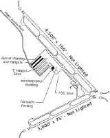
| Runways: | 05/23 12/30 |
| Longest Runway: | 12/30 is 4500 ft (1372 m) long |
| Runways with an Instrument Approach: |
C83 Airport Runway Details
| Runway 05/23 | 3000 ft x 75 ft (914 m x 23 m) | |
| Runway Length Source: | NGS as of 07/16/2005 | |
| Surface: | Asphalt - Good condition - No special surface treatment | |
| Runway Edge Lights: | Medium Intensity | |
Runway Weight Bearing Capacity (in thousands of pounds) |
||
| Single Wheel Landing Gear: | 29.5 | |
Runway 05 |
Runway 23 |
|
Elevation: |
78.5 | 48.6 |
Latitude: |
37-49-20.3509N | 37-49-33.7316N |
Longitude: |
121-37-48.4195W | 121-37-15.0582W |
|
Runway True Alignment: |
063 | 243 |
Glide Path Angle: |
0.0 degrees | 3.5 degrees |
Traffic Pattern: |
Right | |
Runway Markings Type: |
Basic | Basic |
Runway Markings Condition: |
Good | Good |
Object Height: |
180 | |
Distance from End: |
3800 | |
Object Centerline Offset: |
300 ft. left and right of centerline | |
Visual Glide Slope Indicators: |
2-Light PAPI On Left Side Of Runway | |
Threshold Crossing Height: |
25 |
| Runway 12/30 | 4500 ft x 100 ft (1372 m x 30 m) | |
| Runway Length Source: | NGS as of 07/16/2005 | |
| Surface: | Asphalt - Good condition - No special surface treatment | |
| Runway Edge Lights: | Medium Intensity | |
Runway Weight Bearing Capacity (in thousands of pounds) |
||
| Single Wheel Landing Gear: | 29.5 | |
Runway 12 |
Runway 30 |
|
Elevation: |
64.1 | 48.4 |
Latitude: |
37-50-08.4954N | 37-49-36.8929N |
Longitude: |
121-37-53.5205W | 121-37-14.0485W |
|
Runway True Alignment: |
135 | 315 |
Glide Path Angle: |
0.0 degrees | 3.5 degrees |
Traffic Pattern: |
Right | |
Runway Markings Type: |
Nonprecision Instrument | Nonprecision Instrument |
Runway Markings Condition: |
Good | Good |
Object at End: |
POLE | HILL |
Object Height: |
61 | 65 |
Distance from End: |
1591 | 3218 |
Object Centerline Offset: |
300 ft. left and right of centerline | |
Visual Glide Slope Indicators: |
2-Light PAPI On Left Side Of Runway | |
REIL: |
Yes | |
Threshold Crossing Height: |
25 |
Services
Airframe Repair: |
Major |
Powerplant Repair: |
Major |
Bottled Oxygen: |
None |
Bulk Oxygen: |
None |
Fuel Available: |
100LL |
Landing Fees: |
No |
Parking: |
Tiedowns available |
Maps & Diagrams
C83 Sectional
Flight Planning
at skyvector.com
at skyvector.com