Location
Latitude: |
42-46-42.8000N (42.778556) |
Longitude: |
096-11-36.9000W (-96.193583) |
Elevation: |
1197.0 feet MSL (365 m MSL) |
Magnetic Variation: |
2.3 E (as of April 2024 from WMM2020 model) |
Time Zone: |
UTC -6.0 (Standard Time) UTC -5.0 (Daylight Savings Time) |
From City: |
02 N.M. SW of Le Mars, Iowa |
Found On: |
Omaha Chart |
FAA Region: |
ACE |
Contacts
Manager: |
Publicly owned: |
| TOM MULLALLY 1621 AIRPORT DRIVE LE MARS, IA 51031 (712) 540-1665 |
CITY OF LE MARS 22 2ND ST SE LE MARS, IA 51031 712-546-7018 |
Operations
Airport Status: |
Operational |
Facility Use: |
Public |
Type: |
Airport |
Activation Date: |
11/1941 |
Control tower: |
No |
Attendance (Months/Days/Hours): |
Months/Days/Hours ALL/MON-FRI/0800-1730 |
Boundary ARTCC: |
ZMP (Minneapolis) |
Responsible ARTCC: |
ZMP (Minneapolis) |
Lighting Schedule: |
SEE RMK |
Segmented Circle Indicator: |
Yes |
Traffic Pattern Altitude (MSL): |
2197 feet (670 m) |
NOTAMs Facility: |
LRJ |
NOTAM-D Service: |
Yes |
International Airport of Entry: |
No |
Customs Landing Rights: |
No |
Military Landing Rights: |
Yes |
Civil/Military Joint Use: |
No |
Based Aircraft
| Single Engine: | 14 |
| Jet Engine: | 2 |
Annual Operations (as of 09/28/2023)
| Total Operations: | 4750 | |
| GA Local: | 3182 | 67.0% |
| GA Itinerant: | 1546 | 32.5% |
| Military Aircraft: | 22 | 0.5% |
Communications
| CTAF: | 122.800 |
| Unicom: | 122.800 |
| Approach: | SIOUX CITY 124.6 124.6 MINNEAPOLIS ARTCC |
| Departure: | SIOUX CITY 124.6 124.6 MINNEAPOLIS ARTCC |
| AWOS-3P: | 120.975 (712-546-8439) |
- APCH/DEP SVC PRVDD BY MINNEAPOLIS ARTCC ON FREQS 125.025/235.625 (SIOUX CITY RCAG) WHEN SIOUX CITY ATCT CLSD.
Fixed Based Operators (FBOs) & Fuel
(Click on a business for detail)
Please help us keep this information up to date. This is a FREE SERVICE just like everything else on Airport Guide! If you see that a business needs to be added, modified, or deleted please fill out our Update Form.
To add, modify, or delete a business click here.
Please help us keep this information up to date. This is a FREE SERVICE just like everything else on Airport Guide! If you see that a business needs to be added, modified, or deleted please fill out our Update Form.
Area Code: 712 |
| Business Name | Frequency | Phone | Fuel Grade |
|---|---|---|---|
| Plymoth County Aviation
Update FBO info |
546-4724 | 100LL, Jet A |
Flight Service Stations
| Primary | Alternate | |
| FSS on Field: | N | |
| FSS Name (ID): | Fort Dodge(FOD) | |
| Frequency: | ||
| Toll Free Phone: | 1-800-WX-BRIEF |
Instrument Procedures / Charts
FAA Terminal Procedures valid from 0901Z 03/21/24 to 0901Z 04/18/24.
There are various types of charts available for an airport. They are listed in the Page Type column. Here is a legend for those types:
APD - Airport Diagram
DP - Departure Procedure Charts
HOT - Hot Spots
IAP - Instrument Approach Procedure Charts
MIN - Minimums
STAR - Standard Terminal Arrival Charts
| Page Type | Page Name | Volume | Action Since Last Cycle |
|---|---|---|---|
| IAP | RNAV (GPS) RWY 18 | NC-3 | |
| IAP | RNAV (GPS) RWY 36 | NC-3 | |
| MIN | ALTERNATE MINIMUMS | NC-3 | |
| MIN | TAKEOFF MINIMUMS | NC-3 |
Terminal Procedures are only available for airports in several countries with more being added all the time. If you are looking for a specific country's charts, please send an email to support(at)airportguide.com stating the country name. This will be used to prioritize the implementation.
Navigation Aids (Navaids) near LRJ
| Dist (NM) | ID | Morse Code | Name | Type | Freq | True Hdg | Mag Hdg |
|---|---|---|---|---|---|---|---|
| 13.9 | ORC | _ _ _ . _ . _ . _ . | Orange City | NDB | 521 | 24 | 22 |
| 21.3 | SOY | . . . _ _ _ _ . _ _ | Sioux Center | NDB | 368 | 0 | 358 |
| 22.5 | OI | _ _ _ . . | Tommi | NDB | 305 | 211 | 209 |
| 23.8 | GAK | _ _ . . _ _ . _ | Sioux Gateway | NDB | 233 | 200 | 198 |
| 26.7 | SUX | . . . . . _ _ . . _ | Sioux City | TACAN | 116.50 | 192 | 190 |
| 27.4 | SU | . . . . . _ | Salix | NDB | 414 | 189 | 187 |
| 30.5 | SHL | . . . . . . . . _ . . | Sheldon | NDB | 338 | 31 | 29 |
| 40.0 | MEY | _ _ . _ . _ _ | Mapleton | NDB | 335 | 153 | 151 |
| 40.3 | ISB | . . . . . _ . . . | Sibley | NDB | 269 | 28 | 26 |
| 43.2 | SLB | . . . . _ . . _ . . . | Storm Lake | NDB | 434 | 104 | 102 |
| 46.8 | SP | . . . . _ _ . | Snore | NDB | 394 | 53 | 51 |
| 48.9 | YK | _ . _ _ _ . _ | Cagur | NDB | 347 | 274 | 271 |
| 49.3 | SPW | . . . . _ _ . . _ _ | Spencer | VOR-DME | 115.15 | 61 | 59 |
| 51.1 | LTU | . _ . . _ . . _ | Little Sioux | NDB | 326 | 65 | 63 |
| 51.2 | FS | . . _ . . . . | Rokky | NDB | 245 | 327 | 325 |
| 53.1 | YKN | _ . _ _ _ . _ _ . | Yankton | DME | 111.4 | 279 | 276 |
| 58.2 | FSD | . . _ . . . . _ . . | Sioux Falls | VORTAC | 115.00 | 334 | 332 |
| 58.6 | OTG | _ _ _ _ _ _ . | Worthington | DME | 110.6 | 26 | 24 |
| 58.6 | SKI | . . . _ . _ . . | Sac City | NDB | 356 | 113 | 111 |
| 59.6 | OT | _ _ _ _ | Wondd | NDB | 277 | 32 | 30 |
Nearby Airports with Fuel
Notices to Airmen (NOTAMS)
Remarks
| A110-1 | AFT HRS SVC FEE. |
| A110-2 | RY 36 IS CALM WIND RY. |
| A110-3 | FOR CD CTC SIOUX CITY ATCT ON 124.6 OR CALL 712-293-2482. |
| A110-4 | COLD TEMPERATURE AIRPORT. ALTITUDE CORRECTION REQUIRED AT OR BELOW -24C. |
| A15 | EMAIL ADDRESS: ULTRAFLIGHTLLC51031@GMAIL.COM (ALL LOWER CASE) |
| A16 | AFTER HRS NMBR IS 712-540-1665 |
| A51-18 | 36:1 CLEARANCE TO DTHR. |
| A57-18 | OBSTN SLOPE 50:1 TO DTHR. |
| A57-36 | APCH SLOPE 33:1 TO DTHR. |
| A58-18 | 8 FT SHRUBS 25 FT FROM RWY END 85 FT RIGHT ON APCH. |
| A81-APT | ACTVT REIL RWYS 18 & 36; PAPI RWY 18 & 36; MIRL RWY 18/36 - CTAF. |
| E111 | PRVDD APCH TO EACH RWY IS MAINTD FOR A MIN 20:1 GLIDE SLOPE AND THE TRSNL SFC BE MAINTD FOR A 7:1 SLOPE. |
Runways
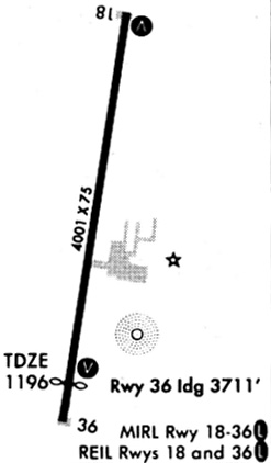
Runway Summary
| Runways: | 18/36 |
| Longest Runway: | 18/36 is 5056 ft (1541 m) long |
| Runways with an Instrument Approach: |
LRJ Airport Runway Details
| Runway 18/36 | 5056 ft x 75 ft (1541 m x 23 m) | |
| Runway Length Source: | 3RD PARTY SURVEY as of 10/01/2020 | |
| Surface: | Concrete - Good condition - No special surface treatment | |
| Runway Pavement Class: | 12 /R/C/W/U | |
| Runway Edge Lights: | Medium Intensity | |
Runway Weight Bearing Capacity (in thousands of pounds) |
||
| Single Wheel Landing Gear: | 28.0 | |
| Dual Wheel Landing Gear: | 48.0 | |
Runway 18 |
Runway 36 |
|
Elevation: |
1193.7 | 1193.3 |
Latitude: |
42-47-07.5531N | 42-46-18.1017N |
Longitude: |
096-11-32.1768W | 096-11-41.5786W |
|
Runway True Alignment: |
188 | 008 |
Glide Path Angle: |
3.0 degrees | 3.0 degrees |
Traffic Pattern: |
Right | Left |
Runway Markings Type: |
Nonprecision Instrument | Nonprecision Instrument |
Runway Markings Condition: |
Fair | Fair |
Object at End: |
TREE | ROAD |
Object Height: |
16 | 15 |
Distance from End: |
282 | 500 |
Object Centerline Offset: |
54 ft. right of centerline | 250 ft. right of centerline |
Visual Glide Slope Indicators: |
2-Light PAPI On Left Side Of Runway | 2-Light PAPI On Right Side Of Runway |
REIL: |
Yes | Yes |
Threshold Crossing Height: |
21 | 31 |
Threshold Elevation: |
1193.6 | 1193.9 |
Displaced Threshold: |
300 | 300 |
Threshold Latitude: |
42-47-04.6191N | 42-46-21.0406N |
Threshold Longitude: |
096-11-32.7321W | 096-11-41.0196W |
Services
Airframe Repair: |
None |
Powerplant Repair: |
None |
Bottled Oxygen: |
None |
Bulk Oxygen: |
None |
Fuel Available: |
100LL, Jet A |
Landing Fees: |
No |
Parking: |
Hangars and tiedowns available |
Maps & Diagrams
LRJ Sectional
Flight Planning
at skyvector.com
at skyvector.com