Location
Latitude: |
32-24-53.6000N (32.414889) |
Longitude: |
098-48-34.9000W (-98.809694) |
Elevation: |
1467.9 feet MSL (447 m MSL) |
Magnetic Variation: |
3.8 E (as of April 2024 from WMM2020 model) |
Time Zone: |
UTC -6.0 (Standard Time) UTC -5.0 (Daylight Savings Time) |
From City: |
01 N.M. N of Eastland, Texas |
Found On: |
Dallas-Ft Worth Chart |
FAA Region: |
ASW |
Contacts
Manager: |
Publicly owned: |
| BODE ZIETZ PO BOX 47 EASTLAND, TX 76448 254-629-1588 |
CITY OF EASTLAND PO BOX 749 EASTLAND, TX 76448 254-629-8321 |
Operations
Airport Status: |
Operational |
Facility Use: |
Public |
Type: |
Airport |
Activation Date: |
10/1945 |
Control tower: |
No |
Attendance (Months/Days/Hours): |
Months/Days/Hours ALL/MON-SAT/0800-1800 |
Boundary ARTCC: |
ZFW (Fort Worth) |
Responsible ARTCC: |
ZFW (Fort Worth) |
Lighting Schedule: |
SEE RMK |
Segmented Circle Indicator: |
Yes |
Traffic Pattern Altitude (MSL): |
2468 feet (752 m) |
NOTAMs Facility: |
FTW |
NOTAM-D Service: |
Yes |
International Airport of Entry: |
No |
Customs Landing Rights: |
No |
Military Landing Rights: |
No |
Civil/Military Joint Use: |
No |
Based Aircraft
| Single Engine: | 18 |
| Multi Engine: | 1 |
| Jet Engine: | 1 |
| GA Helicopters: | 1 |
Annual Operations (as of 05/24/2921)
| Total Operations: | 12000 | |
| GA Local: | 8000 | 66.7% |
| GA Itinerant: | 4000 | 33.3% |
Communications
| CTAF: | 122.800 |
| Unicom: | 122.800 |
| AWOS-3PT: | 118.45 (254-631-0493) |
- APCH/DEP CTL SVC PRVDD BY FORT WORTH ARTCC (ZFW) ON FREQS 127.15/314.0 (DUBLIN/B RCAG).
Fixed Based Operators (FBOs) & Fuel
(Click on a business for detail)
Please help us keep this information up to date. This is a FREE SERVICE just like everything else on Airport Guide! If you see that a business needs to be added, modified, or deleted please fill out our Update Form.
To add, modify, or delete a business click here.
Please help us keep this information up to date. This is a FREE SERVICE just like everything else on Airport Guide! If you see that a business needs to be added, modified, or deleted please fill out our Update Form.
Area Code: 254 |
| Business Name | Frequency | Phone | Fuel Grade |
|---|---|---|---|
| Beaty Aviation
Update FBO info |
Unicom 122.8 | 629-1588 | 100LL |
Flight Service Stations
| Primary | Alternate | |
| FSS on Field: | N | |
| FSS Name (ID): | Fort Worth(FTW) | |
| Frequency: | ||
| Toll Free Phone: | 1-800-WX-BRIEF |
Instrument Procedures / Charts
FAA Terminal Procedures valid from 0901Z 03/21/24 to 0901Z 04/18/24.
There are various types of charts available for an airport. They are listed in the Page Type column. Here is a legend for those types:
APD - Airport Diagram
DP - Departure Procedure Charts
HOT - Hot Spots
IAP - Instrument Approach Procedure Charts
MIN - Minimums
STAR - Standard Terminal Arrival Charts
| Page Type | Page Name | Volume | Action Since Last Cycle |
|---|---|---|---|
| IAP | RNAV (GPS) RWY 17 | SC-2 | |
| IAP | RNAV (GPS) RWY 35 | SC-2 | |
| MIN | ALTERNATE MINIMUMS | SC-2 | |
| MIN | TAKEOFF MINIMUMS | SC-2 |
Terminal Procedures are only available for airports in several countries with more being added all the time. If you are looking for a specific country's charts, please send an email to support(at)airportguide.com stating the country name. This will be used to prioritize the implementation.
Navigation Aids (Navaids) near ETN
| Dist (NM) | ID | Morse Code | Name | Type | Freq | True Hdg | Mag Hdg |
|---|---|---|---|---|---|---|---|
| 1.0 | OIP | _ _ _ . . . _ _ . | Old Rip | NDB | 410 | 181 | 177 |
| 32.2 | BWD | _ . . . . _ _ _ . . | Brownwood | VOR-DME | 113.55 | 193 | 189 |
| 44.4 | AB | . _ _ . . . | Tomhi | NDB | 353 | 261 | 257 |
| 45.1 | MQP | _ _ _ _ . _ . _ _ . | Millsap | VORTAC | 117.70 | 65 | 61 |
| 47.7 | GHX | _ _ . . . . . _ . . _ | Graham | NDB | 371 | 19 | 15 |
| 49.7 | JEN | . _ _ _ . _ . | Glen Rose | TACAN | 115.00 | 107 | 103 |
| 52.2 | TQA | _ _ _ . _ . _ | Tuscola | VOR-DME | 111.60 | 258 | 254 |
| 53.1 | DYS | _ . . _ . _ _ . . . | Dyess | TACAN | 133.60 | 270 | 266 |
| 53.5 | ABI | . _ _ . . . . . | Abilene | VORTAC | 113.70 | 274 | 270 |
| 58.3 | MNZ | _ _ _ . _ _ . . | Hamilton | NDB | 251 | 144 | 140 |
| 65.4 | AKL | . _ _ . _ . _ . . | Haskell | NDB | 407 | 315 | 311 |
| 72.5 | NFW | _ . . . _ . . _ _ | Nas Jrb Fort Worth | TACAN | 108.70 | 72 | 69 |
| 73.8 | UBC | . . _ _ . . . _ . _ . | Ballinger | NDB | 239 | 233 | 229 |
| 77.0 | FTW | . . _ . _ . _ _ | Fort Worth | VOT | 108.20 | 71 | 68 |
| 78.0 | FT | . . _ . _ | Mufin | NDB | 365 | 68 | 65 |
| 78.7 | BBD | _ . . . _ . . . _ . . | Brady | NDB | 380 | 199 | 195 |
| 81.2 | AGJ | . _ _ _ . . _ _ _ | Gooch Springs | VORTAC | 112.50 | 155 | 151 |
| 83.6 | SKB | . . . _ . _ _ . . . | Scotland | NDB | 344 | 11 | 7 |
| 83.7 | UKW | . . _ _ . _ . _ _ | Bowie | VORTAC | 117.15 | 36 | 32 |
| 83.9 | SWW | . . . . _ _ . _ _ | Sweetwater | NDB | 275 | 272 | 268 |
Nearby Airports with Fuel
Notices to Airmen (NOTAMS)
Remarks
| A110-1 | FOR CD CTC FORT WORTH ARTCC AT 817-858-7584. |
| A110-2 | TRML AVBL 24/7 FOR FLT CREWS. |
| A110-3 | 183 FT AGL, 1617 MSL UNLTD/UNMKD ANT, 1000 FM RWY 35 END, 1500 FT R. |
| A14 | MGR CELL 254-488-1055 |
| A54-17 | APCH SLOPE 34:1 TO DSPLCD THR. |
| A57-17 | APCH SLOPE 23:1 TO DSPLCD THR. |
| A57-35 | APCH SLOPE 34:1 TO DSPLCD THR. |
| A70-FUEL-10 | 0LL AFT FUEL HRS CALL 254-488-1055. |
| A81-APT | ACTVT PAPI RWY 17 & 35, MIRL RWY 17/35 - CTAF. |
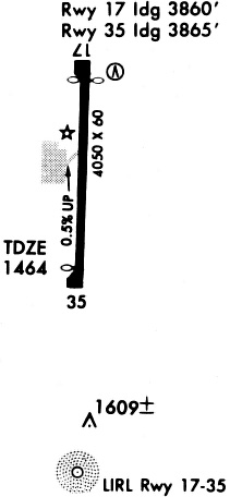
Runways
Runway Summary
| Runways: | 17/35 |
| Longest Runway: | 17/35 is 5000 ft (1524 m) long |
| Runways with an Instrument Approach: |
ETN Airport Runway Details
| Runway 17/35 | 5000 ft x 60 ft (1524 m x 18 m) | |
| Runway Length Source: | 3RD PARTY SURVEY as of 10/04/2006 | |
| Surface: | Asphalt - Good condition - No special surface treatment | |
| Runway Edge Lights: | Medium Intensity | |
Runway Weight Bearing Capacity (in thousands of pounds) |
||
| Single Wheel Landing Gear: | 20.0 | |
Runway 17 |
Runway 35 |
|
Elevation: |
1467.9 | 1445.5 |
Latitude: |
32-25-18.3300N | 32-24-28.8757N |
Longitude: |
098-48-33.9900W | 098-48-35.8455W |
|
Runway True Alignment: |
182 | 002 |
Glide Path Angle: |
3.5 degrees | 3.0 degrees |
Traffic Pattern: |
Left | Left |
Runway Markings Type: |
Nonprecision Instrument | Nonprecision Instrument |
Runway Markings Condition: |
Good | Good |
Object at End: |
POLE | TREES |
Object Height: |
114 | 51 |
Object Marked/Lighted?: |
Lighted | |
Distance from End: |
1814 | 1340 |
Object Centerline Offset: |
33 ft. left of centerline | 370 ft. right of centerline |
Visual Glide Slope Indicators: |
2-Light PAPI On Left Side Of Runway | 2-Light PAPI On Left Side Of Runway |
Threshold Crossing Height: |
48 | 45 |
Threshold Elevation: |
1445.5 | 1444.9 |
Displaced Threshold: |
980 | 420 |
Threshold Latitude: |
32-25-08.6300N | 32-24-33.0200N |
Threshold Longitude: |
098-48-34.3500W | 098-48-35.6900W |
Services
Airframe Repair: |
Minor |
Powerplant Repair: |
Minor |
Bottled Oxygen: |
None |
Bulk Oxygen: |
None |
Fuel Available: |
100LL |
Landing Fees: |
Yes |
Parking: |
Tiedowns available |
Maps & Diagrams
ETN Sectional
Flight Planning
at skyvector.com
at skyvector.com