Location
Latitude: |
35-27-03.9000N (35.451083) |
Longitude: |
100-11-59.7000W (-100.199917) |
Elevation: |
2469.9 feet MSL (753 m MSL) |
Magnetic Variation: |
4.7 E (as of April 2024 from WMM2020 model) |
Time Zone: |
UTC -6.0 (Standard Time) UTC -5.0 (Daylight Savings Time) |
From City: |
04 N.M. E of Wheeler, Texas |
Found On: |
Dallas-Ft Worth Chart |
FAA Region: |
ASW |
Contacts
Manager: |
Publicly owned: |
| PAUL ARGNBRIGHT 505 ALAN BEAN BLVD, PO BOX 98 WHEELER, TX 79096 806-669-4182 |
CITY OF WHEELER TX 501 ALAN BEAN BLVD, PO BOX 98 WHEELER, TX 79096 806-826-3222 |
Operations
Airport Status: |
Operational |
Facility Use: |
Public |
Type: |
Airport |
Activation Date: |
07/1985 |
Control tower: |
No |
Attendance (Months/Days/Hours): |
Months/Days/Hours Unattended |
Boundary ARTCC: |
ZAB (Albuquerque) |
Responsible ARTCC: |
ZAB (Albuquerque) |
Lighting Schedule: |
SS-SR |
Segmented Circle Indicator: |
Yes |
Traffic Pattern Altitude (MSL): |
3470 feet (1058 m) |
NOTAMs Facility: |
FTW |
NOTAM-D Service: |
Yes |
Based Aircraft
| Single Engine: | 1 |
| GA Helicopters: | 1 |
Annual Operations (as of 11/19/2023)
| Total Operations: | 300 | |
| GA Local: | 200 | 66.7% |
| GA Itinerant: | 100 | 33.3% |
Communications
| CTAF: | 122.900 |
- APCH/DEP SVC PRVDD BY ALBUQUERQUE ARTCC (ZAB) ON FREQS 127.85/285.475 (AMARILLO RCAG).
Fixed Based Operators (FBOs) & Fuel
(Click on a business for detail)
Please help us keep this information up to date. This is a FREE SERVICE just like everything else on Airport Guide! If you see that a business needs to be added, modified, or deleted please fill out our Update Form.
To add, modify, or delete a business click here.
Please help us keep this information up to date. This is a FREE SERVICE just like everything else on Airport Guide! If you see that a business needs to be added, modified, or deleted please fill out our Update Form.
Area Code: 806 |
| Business Name | Frequency | Phone | Fuel Grade |
|---|
Flight Service Stations
| Primary | Alternate | |
| FSS on Field: | N | |
| FSS Name (ID): | Fort Worth(FTW) | |
| Frequency: | ||
| Toll Free Phone: | 1-800-WX-BRIEF |
Instrument Procedures / Charts
FAA Terminal Procedures valid from 0901Z 03/21/24 to 0901Z 04/18/24.
There are various types of charts available for an airport. They are listed in the Page Type column. Here is a legend for those types:
APD - Airport Diagram
DP - Departure Procedure Charts
HOT - Hot Spots
IAP - Instrument Approach Procedure Charts
MIN - Minimums
STAR - Standard Terminal Arrival Charts
| Page Type | Page Name | Volume | Action Since Last Cycle |
|---|---|---|---|
| IAP | RNAV (GPS)-A | SC-2 | |
| IAP | RNAV (GPS)-B | SC-2 | |
| MIN | TAKEOFF MINIMUMS | SC-2 |
Terminal Procedures are only available for airports in several countries with more being added all the time. If you are looking for a specific country's charts, please send an email to support(at)airportguide.com stating the country name. This will be used to prioritize the implementation.
Navigation Aids (Navaids) near T59
| Dist (NM) | ID | Morse Code | Name | Type | Freq | True Hdg | Mag Hdg |
|---|---|---|---|---|---|---|---|
| 28.3 | SYO | . . . _ . _ _ _ _ _ | Sayre | VORTAC | 115.20 | 102 | 97 |
| 39.9 | PPA | . _ _ . . _ _ . . _ | Pampa | NDB | 368 | 284 | 279 |
| 48.8 | BZ | _ . . . _ _ . . | Fossi | NDB | 393 | 89 | 85 |
| 50.3 | BFV | _ . . . . . _ . . . . _ | Burns Flat | VORTAC | 110.00 | 104 | 100 |
| 55.8 | MMB | _ _ _ _ _ . . . | Mitbee | VORTAC | 115.60 | 16 | 11 |
| 61.5 | BGD | _ . . . _ _ . _ . . | Borger | TACAN | 108.60 | 290 | 285 |
| 63.5 | PYX | . _ _ . _ . _ _ _ . . _ | Perryton | NDB | 266 | 335 | 330 |
| 65.1 | CDS | _ . _ . _ . . . . . | Childress | VORTAC | 117.00 | 183 | 178 |
| 65.7 | LTS | . _ . . _ . . . | Altus | VORTAC | 109.80 | 135 | 131 |
| 65.9 | HBR | . . . . _ . . . . _ . | Hobart | VORTAC | 111.80 | 121 | 117 |
| 74.5 | PNH | . _ _ . _ . . . . . | Panhandle | VORTAC | 116.60 | 260 | 255 |
| 79.1 | MDF | _ _ _ . . . . _ . | Mooreland | NDB | 284 | 37 | 33 |
| 80.7 | AM | . _ _ _ | Pande | NDB | 251 | 257 | 252 |
| 89.3 | BFK | _ . . . . . _ . _ . _ | Buffalo | NDB | 215 | 18 | 13 |
| 96.9 | OFZ | _ _ _ . . _ . _ _ . . | Trail | NDB | 388 | 113 | 109 |
| 96.9 | FSI | . . _ . . . . . . | Trail | FAN MARKER | 113 | 109 | |
| 97.9 | LB | . _ . . _ . . . | Panck | NDB | 383 | 338 | 333 |
| 98.3 | GUY | _ _ . . . _ _ . _ _ | Guymon | NDB | 275 | 320 | 315 |
Nearby Airports with Fuel
Notices to Airmen (NOTAMS)
Remarks
| A110*G | THIS AIRPORT HAS BEEN SURVEYED BY THE NATIONAL GEODETIC SURVEY. |
| A110-2 | 10 FT RISING TRRN 100 FT BOTH SIDES OF CNTRLN. |
| A110-3 | FOR CD CTC ALBUQUERQUE ARTCC AT 505-856-4861. |
| A110-4 | RWY PAVEMENT CRACKING WITH VEGETATION GROWING THROUGH. |
| A110-5 | LIRL RWY 17/35 NMRS LTS OTS. |
| A14 | PUBLIC WORKS DIRECTOR |
| A57-35 | APCH SLOPE 31:1 TO DSPLCD THLD. |
Runways
Runway Summary
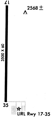
| Runways: | 17/35 |
| Longest Runway: | 17/35 is 3565 ft (1087 m) long |
| Runways with an Instrument Approach: |
T59 Airport Runway Details
| Runway 17/35 | 3565 ft x 60 ft (1087 m x 18 m) | |
| Runway Length Source: | NGS as of 08/04/1995 | |
| Surface: | Asphalt - Fair condition - No special surface treatment | |
| Runway Edge Lights: | Low Intensity | |
Runway Weight Bearing Capacity (in thousands of pounds) |
||
| Single Wheel Landing Gear: | 12.0 | |
Runway 17 |
Runway 35 |
|
Elevation: |
2430.6 | 2469.9 |
Latitude: |
35-27-21.4739N | 35-26-46.2238N |
Longitude: |
100-11-59.7805W | 100-11-59.5423W |
|
Runway True Alignment: |
180 | 360 |
Glide Path Angle: |
0.0 degrees | 0.0 degrees |
Runway Markings Type: |
Nonprecision Instrument | Nonprecision Instrument |
Runway Markings Condition: |
Fair | Fair |
Object at End: |
ROAD | |
Object Height: |
20 | |
Distance from End: |
564 | |
Object Centerline Offset: |
0 ft. left and right of centerline | |
Threshold Elevation: |
2469.7 | |
Displaced Threshold: |
57 | |
Threshold Latitude: |
35-26-46.7845N | |
Threshold Longitude: |
100-11-59.5461W |
Services
Airframe Repair: |
None |
Powerplant Repair: |
None |
Bottled Oxygen: |
None |
Bulk Oxygen: |
None |
Fuel Available: |
100LL |
Landing Fees: |
No |
Parking: |
Hangars available |
Maps & Diagrams
T59 Sectional
Flight Planning
at skyvector.com
at skyvector.com