Location
Latitude: |
40-22-42.5950N (40.378499) |
Longitude: |
075-57-54.8900W (-75.965247) |
Elevation: |
343.4 feet MSL (105 m MSL) |
Magnetic Variation: |
11.6 W (as of May 2024 from WMM2020 model) |
Time Zone: |
UTC -5.0 (Standard Time) UTC -4.0 (Daylight Savings Time) |
From City: |
03 N.M. NW of Reading, Pennsylvania |
Found On: |
New York Chart |
FAA Region: |
AEA |
Contacts
Manager: |
Publicly owned: |
| ZACKARY J. TEMPESCO 2501 BERNVILLE RD READING, PA 19605 610-372-4666 |
READING REGIONAL ARPT AUTH. 2501 BERNVILLE RD READING, PA 19605 610-372-4666 |
Operations
Airport Status: |
Operational |
Facility Use: |
Public |
Type: |
Airport |
Activation Date: |
04/1938 |
Control tower: |
Yes |
Attendance (Months/Days/Hours): |
Months/Days/Hours ALL/ALL/0600-2300 |
Boundary ARTCC: |
ZNY (New York) |
Responsible ARTCC: |
ZNY (New York) |
Lighting Schedule: |
SEE RMK |
Segmented Circle Indicator: |
No |
Traffic Pattern Altitude (MSL): |
1343 feet (409 m) |
NOTAMs Facility: |
RDG |
NOTAM-D Service: |
Yes |
International Airport of Entry: |
No |
Customs Landing Rights: |
No |
Military Landing Rights: |
Yes |
Civil/Military Joint Use: |
No |
Aircraft Rescue and Firefighting: |
Class IV ARFF Index: A Air Carrier Service: Not Scheduled Certification Date: 04/1975 |
Based Aircraft
| Single Engine: | 77 |
| Multi Engine: | 19 |
| Jet Engine: | 14 |
| GA Helicopters: | 4 |
| Gliders: | 1 |
Annual Operations (as of 12/31/2022)
| Total Operations: | 38139 | |
| Commercial: | 68 | 0.2% |
| Air Taxi: | 4442 | 11.6% |
| GA Local: | 11097 | 29.1% |
| GA Itinerant: | 21441 | 56.2% |
| Military Aircraft: | 1091 | 2.9% |
Communications
| CTAF: | 119.900 |
| Unicom: | 122.950 |
| Tower: | READING 119.9 288.3 Hrs: 0600-0000 |
| Ground: | 121.9 |
| Approach: | READING 125.15 257.9 Hrs: 0600-0000 HARRISBURG 124.1 124.1 Hrs: 0000-0600 |
| Departure: | READING 125.15 257.9 Hrs: 0600-0000 HARRISBURG 124.1 124.1 Hrs: 0000-0600 |
| ATIS: | 127.1 Hrs: 24 |
| ASOS: | 127.1 (610-372-9863) |
| EMERG: | 121.5 |
| EMERG: | 243.0 |
Fixed Based Operators (FBOs) & Fuel
(Click on a business for detail)
Please help us keep this information up to date. This is a FREE SERVICE just like everything else on Airport Guide! If you see that a business needs to be added, modified, or deleted please fill out our Update Form.
To add, modify, or delete a business click here.
Please help us keep this information up to date. This is a FREE SERVICE just like everything else on Airport Guide! If you see that a business needs to be added, modified, or deleted please fill out our Update Form.
Area Code: 610 |
| Business Name | Frequency | Phone | Fuel Grade |
|---|---|---|---|
| Aerodynamics of Reading, Inc.
Update FBO info |
Unicom 122.875 | 373-3000 | 100LL, Jet A |

|
 Avfuel |
100LL - 6.11 USD per gallon on 04/21/2023 |
|
| Marc Fruchter Aviation / Avitat
Website Update FBO info |
374-0100, 800-366-9419 | 100LL, Jet A | |
| Mid Atlantic Air Museum
Website Update FBO info |
372-7333 | ||
| Reading Flite Academy
Website Update FBO info |
Unicom 123.1 | 376-5447, 888-801-0049 | 100LL, Jet A |
Flight Service Stations
| Primary | Alternate | |
| FSS on Field: | N | |
| FSS Name (ID): | Williamsport(IPT) | |
| Frequency: | ||
| Toll Free Phone: | 1-800-WX-BRIEF |
Instrument Procedures / Charts
FAA Terminal Procedures valid from 0901Z 03/21/24 to 0901Z 04/18/24.
There are various types of charts available for an airport. They are listed in the Page Type column. Here is a legend for those types:
APD - Airport Diagram
DP - Departure Procedure Charts
HOT - Hot Spots
IAP - Instrument Approach Procedure Charts
MIN - Minimums
STAR - Standard Terminal Arrival Charts
| Page Type | Page Name | Volume | Action Since Last Cycle |
|---|---|---|---|
| APD | AIRPORT DIAGRAM | NE-4 | Changed |
| HOT | HOT SPOT | NE-4 | |
| IAP | ILS OR LOC RWY 13 | NE-4 | |
| IAP | ILS OR LOC RWY 36 | NE-4 | |
| IAP | RNAV (GPS) RWY 13 | NE-4 | |
| IAP | RNAV (GPS) RWY 18 | NE-4 | |
| IAP | RNAV (GPS) RWY 31 | NE-4 | |
| IAP | RNAV (GPS) RWY 36 | NE-4 | |
| LAH | LAHSO | NE-4 | |
| MIN | ALTERNATE MINIMUMS | NE-4 | |
| MIN | TAKEOFF MINIMUMS | NE-4 |
Terminal Procedures are only available for airports in several countries with more being added all the time. If you are looking for a specific country's charts, please send an email to support(at)airportguide.com stating the country name. This will be used to prioritize the implementation.
Navigation Aids (Navaids) near RDG
| Dist (NM) | ID | Morse Code | Name | Type | Freq | True Hdg | Mag Hdg |
|---|---|---|---|---|---|---|---|
| 17.7 | ETX | . _ _ . . _ | East Texas | VOR-DME | 110.20 | 46 | 58 |
| 20.8 | PTW | . _ _ . _ . _ _ | Pottstown | VORTAC | 116.50 | 116 | 128 |
| 21.5 | LRP | . _ . . . _ . . _ _ . | Lancaster | VOR-DME | 117.30 | 224 | 236 |
| 27.1 | BZJ | _ . . . _ _ . . . _ _ _ | Bellgrove | NDB | 328 | 277 | 288 |
| 30.6 | UKT | . . _ _ . _ _ | Quakertown | NDB | 208 | 84 | 96 |
| 30.7 | MXE | _ _ _ . . _ . | Modena | VORTAC | 113.20 | 153 | 165 |
| 30.8 | RAV | . _ . . _ . . . _ | Ravine | VORTAC | 114.60 | 290 | 301 |
| 31.3 | FJC | . . _ . . _ _ _ _ . _ . | Allentown | VORTAC | 117.50 | 47 | 59 |
| 34.6 | ING | . . _ . _ _ . | Ambler | NDB | 275 | 115 | 127 |
| 36.5 | HZL | . . . . _ _ . . . _ . . | Hazleton | VOR | 109.40 | 348 | 360 |
| 38.1 | MDT | _ _ _ . . _ | Harrisburg | VOT | 110.00 | 253 | 264 |
| 43.5 | MD | _ _ _ . . | Enola | NDB | 204 | 259 | 270 |
| 45.1 | DQO | _ . . _ _ . _ _ _ _ | Dupont | VORTAC | 114.00 | 158 | 170 |
| 45.5 | PHL | . _ _ . . . . . . _ . . | Philadelphia | VOT | 109.80 | 132 | 144 |
| 47.2 | PNE | . _ _ . _ . . | North Philadelphia | VOR | 112.00 | 111 | 123 |
| 48.6 | SEG | . . . . _ _ . | Selinsgrove | VOR-DME | 110.40 | 300 | 311 |
| 49.0 | ARD | . _ . _ . _ . . | Yardley | VOR-DME | 108.20 | 98 | 110 |
| 49.1 | CX | _ . _ . _ . . _ | Latle | NDB | 219 | 256 | 267 |
| 50.1 | EUD | . . . _ _ . . | York | NDB | 254 | 236 | 247 |
| 50.1 | MIP | _ _ . . . _ _ . | Milton | VORTAC | 109.20 | 320 | 331 |
Nearby Airports with Fuel
Notices to Airmen (NOTAMS)
Remarks
| A110-1 | BIRDS ON & INVOF ARPT. |
| A110-2 | FOR CD WHEN ATCT CLSD, CTC HARRISBURG APCH AT 800-932-0712. |
| A24 | LNDG FEE FOR TURBINE ACFT. |
| A26 | PPR 24 HRS FOR ACFT OPNS WITH MORE THAN 30 PAX SEATS. CALL AMGR 610-372-4666. |
| A43-13 | PAPI UNUSBL BYD 3 DEGS LEFT OF CNTRLN. |
| A81-APT | WHEN ATCT CLSD ACTVT MALSF RWY 36; REIL RWY 13, 31; PAPI RWY 13 & 18; HIRL RWY 13/31 & 18/36; TWY LGTS - CTAF. |
| E60-13 | ARRESTING GEAR/SYSTEM: ENGINEERED MATERIAL ARRESTING SYSTEM (EMAS) 255 FT IN LENGTH BY 170 FT IN WIDTH LOCATED AT DEP END RWY 13. |
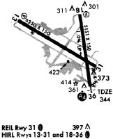
Runways
Runway Summary
| Runways: | 13/31 18/36 |
| Longest Runway: | 13/31 is 6350 ft (1935 m) long |
| Runways with an Instrument Approach: | 13, 36 |
RDG Airport Runway Details
| Runway 13/31 | 6350 ft x 150 ft (1935 m x 46 m) | |
| Runway Length Source: | 3RD PARTY SURVEY as of 12/07/2018 | |
| Surface: | Asphalt - Good condition - Saw-cut or plastic grooved | |
| Runway Pavement Class: | 60 /F/C/X/U | |
| Runway Edge Lights: | High Intensity | |
Runway Weight Bearing Capacity (in thousands of pounds) |
||
| Single Wheel Landing Gear: | 75.0 | |
| Dual Wheel Landing Gear: | 200.0 | |
| Dual Tandem Wheel Landing Gear: | 400.0 | |
Runway 13 |
Runway 31 |
|
Elevation: |
343.4 | 329.7 |
Latitude: |
40-23-00.8589N | 40-22-28.2921N |
Longitude: |
075-58-41.1671W | 075-57-31.0421W |
|
Runway True Alignment: |
121 | 301 |
ILS Type: |
ILS/DME | |
Glide Path Angle: |
3.0 degrees | 0.0 degrees |
Traffic Pattern: |
Left | |
Runway Markings Type: |
Precision Instrument | Precision Instrument |
Runway Markings Condition: |
Good | Good |
Arresting Device: |
EMAS | |
Object at End: |
TREES | |
Object Height: |
317 | |
Distance from End: |
7661 | |
Object Centerline Offset: |
1213 ft. left of centerline | |
Visual Glide Slope Indicators: |
4-Light PAPI On Left Side Of Runway | |
REIL: |
Yes | Yes |
Threshold Crossing Height: |
45 | |
Declared Distances |
||
Take Off Run Avbl. (TORA): |
6350 | 6350 |
Take Off Distance Avbl. (TODA): |
6350 | 6350 |
Actual Stop Dist. Avbl. (ASDA): |
6350 | 6350 |
Landing Dist. Avbl. (LDA): |
6350 | 6350 |
| Runway 18/36 | 5151 ft x 150 ft (1570 m x 46 m) | |
| Runway Length Source: | 3RD PARTY SURVEY as of 12/07/2018 | |
| Surface: | Asphalt - Good condition - Saw-cut or plastic grooved | |
| Runway Pavement Class: | 60 /F/C/X/U | |
| Runway Edge Lights: | High Intensity | |
Runway Weight Bearing Capacity (in thousands of pounds) |
||
| Single Wheel Landing Gear: | 75.0 | |
| Dual Wheel Landing Gear: | 200.0 | |
| Dual Tandem Wheel Landing Gear: | 400.0 | |
Runway 18 |
Runway 36 |
|
Elevation: |
290.4 | 342.3 |
Latitude: |
40-23-05.3619N | 40-22-14.9398N |
Longitude: |
075-57-45.6015W | 075-57-36.5380W |
|
Runway True Alignment: |
172 | 352 |
ILS Type: |
ILS | |
Glide Path Angle: |
3.0 degrees | 0.0 degrees |
Traffic Pattern: |
Left | Left |
Runway Markings Type: |
Precision Instrument | Precision Instrument |
Runway Markings Condition: |
Good | Good |
Object at End: |
TREES | TREES |
Object Height: |
56 | 17 |
Distance from End: |
893 | 769 |
Object Centerline Offset: |
1213 ft. left of centerline | |
Visual Glide Slope Indicators: |
4-Light PAPI On Left Side Of Runway | |
Runway Visual Range (RVR): |
Touchdown | |
Approach Light System: |
1,400 Foot Medium Intensity Approach Lighting System With Sequenced Flashers | |
Threshold Crossing Height: |
56 | |
Declared Distances |
||
Take Off Run Avbl. (TORA): |
5151 | 5151 |
Take Off Distance Avbl. (TODA): |
5151 | 5151 |
Actual Stop Dist. Avbl. (ASDA): |
5151 | 5151 |
Landing Dist. Avbl. (LDA): |
5151 | 5151 |
Services
Airframe Repair: |
Minor |
Powerplant Repair: |
Minor |
Bottled Oxygen: |
High Pressure |
Bulk Oxygen: |
None |
Fuel Available: |
100LL, Jet A |
Landing Fees: |
No |
Parking: |
Hangars and tiedowns available |
Maps & Diagrams
RDG Sectional
Flight Planning
at skyvector.com
at skyvector.com