Location
Latitude: |
40-12-07.3890N (40.202053) |
Longitude: |
075-10-41.6250W (-75.178229) |
Elevation: |
250.0 feet MSL (76 m MSL) |
Magnetic Variation: |
11.9 W (as of April 2024 from WMM2020 model) |
Time Zone: |
UTC -5.0 (Standard Time) UTC -4.0 (Daylight Savings Time) |
From City: |
02 N.M. NW of Horsham, Pennsylvania |
Found On: |
New York Chart |
FAA Region: |
AEA |
Contacts
Manager: |
Privately owned: |
| HOYT BANGS 450 CAREDEAN DR HORSHAM, PA 19044 215-674-2100 |
HORSHAM VALLEY AIRWAYS INC 450 CAREDEAN DRIVE HORSHAM, PA 19044 215-674-2100 |
Operations
Airport Status: |
Operational |
Facility Use: |
Public |
Type: |
Heliport |
Activation Date: |
06/1980 |
Control tower: |
No |
Attendance (Months/Days/Hours): |
Months/Days/Hours Unattended |
Boundary ARTCC: |
ZNY (New York) |
Responsible ARTCC: |
ZNY (New York) |
Lighting Schedule: |
SS-SR |
Segmented Circle Indicator: |
No |
Traffic Pattern Altitude (MSL): |
1250 feet (381 m) |
NOTAMs Facility: |
IPT |
NOTAM-D Service: |
Yes |
Based Aircraft
Annual Operations (as of 02/21/2023)
| Total Operations: | 120 | |
| GA Local: | 120 | 100.0% |
Communications
| CTAF: | 123.075 |
| Unicom: | 123.075 |
Fixed Based Operators (FBOs) & Fuel
(Click on a business for detail)
Please help us keep this information up to date. This is a FREE SERVICE just like everything else on Airport Guide! If you see that a business needs to be added, modified, or deleted please fill out our Update Form.
To add, modify, or delete a business click here.
Please help us keep this information up to date. This is a FREE SERVICE just like everything else on Airport Guide! If you see that a business needs to be added, modified, or deleted please fill out our Update Form.
Area Code: 215 |
| Business Name | Frequency | Phone | Fuel Grade |
|---|
Flight Service Stations
| Primary | Alternate | |
| FSS on Field: | N | |
| FSS Name (ID): | Williamsport(IPT) | |
| Frequency: | ||
| Toll Free Phone: | 1-800-WX-BRIEF |
Instrument Procedures / Charts
Terminal Procedures are only available for airports in several countries with more being added all the time. If you are looking for a specific country's charts, please send an email to support(at)airportguide.com stating the country name. This will be used to prioritize the implementation.
Navigation Aids (Navaids) near N48
| Dist (NM) | ID | Morse Code | Name | Type | Freq | True Hdg | Mag Hdg |
|---|---|---|---|---|---|---|---|
| 6.7 | ING | . . _ . _ _ . | Ambler | NDB | 275 | 227 | 239 |
| 10.6 | PNE | . _ _ . _ . . | North Philadelphia | VOR | 112.00 | 132 | 144 |
| 12.8 | ARD | . _ . _ . _ . . | Yardley | VOR-DME | 108.20 | 75 | 87 |
| 14.4 | UKT | . . _ _ . _ _ | Quakertown | NDB | 208 | 337 | 349 |
| 17.5 | PTW | . _ _ . _ . _ _ | Pottstown | VORTAC | 116.50 | 274 | 286 |
| 20.4 | PHL | . _ _ . . . . . . _ . . | Philadelphia | VOT | 109.80 | 187 | 199 |
| 28.3 | MXE | _ _ _ . . _ . | Modena | VORTAC | 113.20 | 233 | 245 |
| 29.1 | GXU | _ _ . _ . . _ . . _ | Mc Guire | VORTAC | 110.60 | 113 | 125 |
| 30.3 | SBJ | . . . _ . . . . _ _ _ | Solberg | VOR-DME | 112.90 | 40 | 52 |
| 31.3 | RBV | . _ . _ . . . . . . _ | Robbinsville | VORTAC | 113.80 | 89 | 101 |
| 32.4 | ETX | . _ _ . . _ | East Texas | VOR-DME | 110.20 | 314 | 326 |
| 33.9 | FJC | . . _ . . _ _ _ _ . _ . | Allentown | VORTAC | 117.50 | 338 | 350 |
| 34.4 | OOD | _ _ _ _ _ _ _ . . | Woodstown | VORTAC | 112.80 | 189 | 201 |
| 37.1 | DQO | _ . . _ _ . _ _ _ _ | Dupont | VORTAC | 114.00 | 212 | 224 |
| 39.1 | NEL | _ . . . _ . . | Lakehurst | TACAN | 111.80 | 104 | 116 |
| 39.3 | BWZ | _ . . . . _ _ _ _ . . | Broadway | VOR-DME | 114.20 | 24 | 36 |
| 39.8 | NEL | _ . . . _ . . | Lakehurst | NDB | 396 | 103 | 115 |
| 41.0 | VCN | . . . _ _ . _ . _ . | Cedar Lake | VOR-DME | 115.20 | 166 | 178 |
| 41.4 | CYN | _ . _ . _ . _ _ _ . | Coyle | VORTAC | 113.40 | 123 | 135 |
| 42.3 | IL | . . . _ . . | Hadin | NDB | 248 | 208 | 220 |
Nearby Airports with Fuel
Notices to Airmen (NOTAMS)
Remarks
| A110-1 | AVOID OVERFLIGHT OF HOUSES EAST & WEST. |
| A110-2 | FOR CD CTC PHILADELPHIA APCH AT 800-354-9884. |
| A17 | FOR ATTENDANT CALL 215-674-2100. |
| A30-H1 | INGRESS 240; EGRESS 060. |
| A40-H1 | FLOOD LGTS FM BLDGS. AVBL UPON REQ. |
| E111 | ASP DETERMINATION PENDING. |
Runways
Runway Summary
| Runways: | H1 |
| Longest Runway: | H1 is 60 ft (18 m) long |
| Runways with an Instrument Approach: |
N48 Airport Runway Details
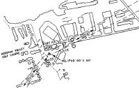
| Helipad H1 | 60 ft x 60 ft (18 m x 18 m) | |
| Surface: | Asphalt - No special surface treatment | |
| Runway Edge Lights: | Flood lights (for helipads) Intensity | |
Helipad H1 |
||
Elevation: |
250.0 | |
Latitude: |
40-12-07.3890N | |
Longitude: |
075-10-41.6250W | |
Glide Path Angle: |
0.0 degrees | 0.0 degrees |
Services
Airframe Repair: |
None |
Powerplant Repair: |
None |
Bottled Oxygen: |
None |
Bulk Oxygen: |
None |
Fuel Available: |
100LL |
Landing Fees: |
No |
Parking: |
Tiedowns available |
Maps & Diagrams
N48 Sectional
Flight Planning
at skyvector.com
at skyvector.com