Location
Latitude: |
41-36-35.2029N (41.609778) |
Longitude: |
084-07-37.8788W (-84.127188) |
Elevation: |
780.8 feet MSL (238 m MSL) |
Magnetic Variation: |
6.7 W (as of May 2024 from WMM2020 model) |
Time Zone: |
UTC -5.0 (Standard Time) UTC -4.0 (Daylight Savings Time) |
From City: |
04 N.M. N of Wauseon, Ohio |
Found On: |
Detroit Chart |
FAA Region: |
AGL |
Contacts
Manager: |
Publicly owned: |
| JOHN CRISP 9460 COUNTY ROAD 14 WAUSEON, OH 43567-9670 419-335-3993 |
FULTON COUNTY 9460 COUNTY ROAD 14 WAUSEON, OH 43567-9670 419-337-9255 |
Operations
Airport Status: |
Operational |
Facility Use: |
Public |
Type: |
Airport |
Control tower: |
No |
Attendance (Months/Days/Hours): |
Months/Days/Hours ALL/MON-SAT/0800-1700 |
Boundary ARTCC: |
ZOB (Cleveland) |
Responsible ARTCC: |
ZOB (Cleveland) |
Lighting Schedule: |
SEE RMK |
Segmented Circle Indicator: |
No |
Traffic Pattern Altitude (MSL): |
1781 feet (543 m) |
NOTAMs Facility: |
USE |
NOTAM-D Service: |
Yes |
International Airport of Entry: |
No |
Customs Landing Rights: |
No |
Military Landing Rights: |
No |
Civil/Military Joint Use: |
No |
Based Aircraft
| Single Engine: | 21 |
| Gliders: | 1 |
Annual Operations (as of 06/30/2022)
| Total Operations: | 22510 | |
| Air Taxi: | 500 | 2.2% |
| GA Local: | 12000 | 53.3% |
| GA Itinerant: | 10000 | 44.4% |
| Military Aircraft: | 10 | 0.0% |
Communications
| CTAF: | 123.000 |
| Unicom: | 123.000 |
| Approach: | TOLEDO 134.35 134.35 |
| Departure: | TOLEDO 134.35 134.35 |
| AWOS-3P: | 127.375 (419-335-0775) |
Fixed Based Operators (FBOs) & Fuel
(Click on a business for detail)
Please help us keep this information up to date. This is a FREE SERVICE just like everything else on Airport Guide! If you see that a business needs to be added, modified, or deleted please fill out our Update Form.
To add, modify, or delete a business click here.
Please help us keep this information up to date. This is a FREE SERVICE just like everything else on Airport Guide! If you see that a business needs to be added, modified, or deleted please fill out our Update Form.
Area Code: 419 |
| Business Name | Frequency | Phone | Fuel Grade |
|---|
Flight Service Stations
| Primary | Alternate | |
| FSS on Field: | N | |
| FSS Name (ID): | Cleveland(CLE) | |
| Frequency: | ||
| Toll Free Phone: | 1-800-WX-BRIEF |
Instrument Procedures / Charts
FAA Terminal Procedures valid from 0901Z 03/21/24 to 0901Z 04/18/24.
There are various types of charts available for an airport. They are listed in the Page Type column. Here is a legend for those types:
APD - Airport Diagram
DP - Departure Procedure Charts
HOT - Hot Spots
IAP - Instrument Approach Procedure Charts
MIN - Minimums
STAR - Standard Terminal Arrival Charts
| Page Type | Page Name | Volume | Action Since Last Cycle |
|---|---|---|---|
| IAP | RNAV (GPS) RWY 09 | EC-2 | |
| IAP | RNAV (GPS) RWY 27 | EC-2 | |
| MIN | TAKEOFF MINIMUMS | EC-2 |
Terminal Procedures are only available for airports in several countries with more being added all the time. If you are looking for a specific country's charts, please send an email to support(at)airportguide.com stating the country name. This will be used to prioritize the implementation.
Navigation Aids (Navaids) near KUSE
| Dist (NM) | ID | Morse Code | Name | Type | Freq | True Hdg | Mag Hdg |
|---|---|---|---|---|---|---|---|
| 0.2 | USE | . . _ . . . . | Fulton | NDB | 375 | 259 | 266 |
| 9.8 | TO | _ _ _ _ | Tophr | NDB | 219 | 110 | 117 |
| 14.7 | TOL | _ _ _ _ . _ . . | Toledo | TACAN | 112.50 | 93 | 100 |
| 15.8 | ADG | . _ _ . . _ _ . | Adrian | NDB | 278 | 8 | 15 |
| 23.9 | VWV | . . . _ . _ _ . . . _ | Waterville | VOR-DME | 113.10 | 113 | 120 |
| 27.6 | TCU | _ _ . _ . . . _ | Tecumseh | NDB | 239 | 22 | 29 |
| 39.4 | LFD | . _ . . . . _ . _ . . | Litchfield | VOR-DME | 111.20 | 313 | 320 |
| 39.8 | CRL | _ . _ . . _ . . _ . . | Carleton | VOR-DME | 115.70 | 48 | 55 |
| 40.9 | BNR | _ . . . _ . . _ . | Benton Ridge | NDB | 334 | 149 | 156 |
| 40.9 | GW | _ _ . . _ _ | Shenk | NDB | 227 | 244 | 250 |
| 41.4 | FZI | . . _ . _ _ . . . . | Fostoria | NDB | 379 | 127 | 134 |
| 41.7 | JXN | . _ _ _ _ . . _ _ . | Jackson | DME | 115.45 | 339 | 346 |
| 42.7 | FBC | . . _ . _ . . . _ . _ . | Flag City | VORTAC | 108.20 | 156 | 163 |
| 43.1 | ANQ | . _ _ . _ _ . _ | Angola | NDB | 347 | 272 | 278 |
| 43.8 | JX | . _ _ _ _ . . _ | Jakso | NDB | 212 | 346 | 353 |
| 46.2 | YIP | _ . _ _ . . . _ _ . | Willow Run | VOT | 108.85 | 35 | 42 |
| 49.6 | DXO | _ . . _ . . _ _ _ _ | Detroit | VOR-DME | 113.40 | 42 | 49 |
| 49.9 | VFU | . . . _ . . _ . . . _ | Stanley | NDB | 411 | 206 | 212 |
| 50.7 | DTW | _ . . _ . _ _ | Detroit Met Wayne | VOT | 109.80 | 42 | 49 |
| 51.4 | TII | _ . . . . | Tiffin | NDB | 269 | 126 | 133 |
Nearby Airports with Fuel
Notices to Airmen (NOTAMS)
Remarks
| A110-2 | DEER ON & INVOF ARPT. |
| A110-5 | RESTROOM ACCESS, UNICOM. |
| A110-6 | FOR CD CTC TOLEDO APCH AT 419-865-1495. |
| A110-7 | RWY 27 CLIMB STRAIGHT OUT TO 1300 MSL. |
| A14 | KUSE@FULTONCOUNTYOH.COM. |
| A17 | FOR SVC AFT HRS CALL AMGR. |
| A33-18/36 | 359 FT OF CNTR SECTION ASPH, NORTH 270 FT TURF, SOUTH 1328 FT TURF. |
| A42-09 | FADED. |
| A42-27 | FADED. |
| A58-09 | +10 FT ACFT RAMP/PRKG, 0-142 FT DIST, 202-250 FT R. |
| A70-FUEL-10 | 0LL 100LL AVBL H24 SELF SVC VIA CREDIT CARD. |
| A70-FUEL-A | FOR JET A AFT HRS CALL AMGR. |
| A70-FUEL-UL | 94 UL94 AVBL H24 SELF SVC VIA CREDIT CARD. |
| A75 | PRIOR CDN RQRD. |
| A75 1 | TIEDOWN ROPES NOT PRVDD. |
| A81-APT | ACTVT REIL RWY 09 & 27; PAPI RWY 09 & 27; MIRL RWY 09/27 - CTAF. |
Runways
Runway Summary
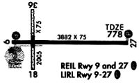
| Runways: | 09/27 18/36 |
| Longest Runway: | 09/27 is 3882 ft (1183 m) long |
| Runways with an Instrument Approach: |
KUSE Airport Runway Details
| Runway 09/27 | 3882 ft x 75 ft (1183 m x 23 m) | |
| Runway Length Source: | 3RD PARTY SURVEY as of 02/07/2011 | |
| Surface: | Asphalt - Good condition - No special surface treatment | |
| Runway Edge Lights: | Medium Intensity | |
Runway Weight Bearing Capacity (in thousands of pounds) |
||
| Single Wheel Landing Gear: | 30.0 | |
Runway 09 |
Runway 27 |
|
Elevation: |
778.8 | 770.0 |
Latitude: |
41-36-36.9339N | 41-36-37.5476N |
Longitude: |
084-07-57.4665W | 084-07-06.3691W |
|
Runway True Alignment: |
089 | 269 |
Glide Path Angle: |
3.0 degrees | 3.0 degrees |
Traffic Pattern: |
Left | Left |
Runway Markings Type: |
Nonprecision Instrument | Nonprecision Instrument |
Runway Markings Condition: |
Poor | Poor |
Object at End: |
ROAD | TREES |
Object Height: |
15 | 70 |
Distance from End: |
457 | 1417 |
Object Centerline Offset: |
0 ft. left and right of centerline | 429 ft. left of centerline |
Visual Glide Slope Indicators: |
4-Light PAPI On Left Side Of Runway | 4-Light PAPI On Right Side Of Runway |
REIL: |
Yes | Yes |
Touchdown Lights: |
No | No |
Centerline Lights: |
No | No |
Threshold Crossing Height: |
24 | 33 |
| Runway 18/36 | 2115 ft x 75 ft (645 m x 23 m) | |
| Runway Length Source: | 3RD PARTY SURVEY as of 02/07/2011 | |
| Surface: | Asphalt - Good condition - No special surface treatment | |
Runway 18 |
Runway 36 |
|
Elevation: |
777.0 | 780.6 |
Latitude: |
41-36-41.9119N | 41-36-21.0129N |
Longitude: |
084-07-48.8287W | 084-07-48.8110W |
|
Runway True Alignment: |
180 | 360 |
Glide Path Angle: |
0.0 degrees | 0.0 degrees |
Traffic Pattern: |
Left | Left |
Object at End: |
TREE | |
Object Height: |
67 | |
Distance from End: |
1149 | |
Object Centerline Offset: |
0 ft. left and right of centerline | 429 ft. left of centerline |
Services
Airframe Repair: |
None |
Powerplant Repair: |
None |
Bottled Oxygen: |
None |
Bulk Oxygen: |
None |
Fuel Available: |
100LL |
Landing Fees: |
No |
Parking: |
Tiedowns available |
Maps & Diagrams
KUSE Sectional
Flight Planning
at skyvector.com
at skyvector.com