Location
Latitude: |
41-35-12.5400N (41.586817) |
Longitude: |
083-48-28.1760W (-83.807827) |
Elevation: |
683.9 feet MSL (208 m MSL) |
Magnetic Variation: |
6.9 W (as of April 2024 from WMM2020 model) |
Time Zone: |
UTC -5.0 (Standard Time) UTC -4.0 (Daylight Savings Time) |
From City: |
10 N.M. SW of Toledo, Ohio |
Found On: |
Detroit Chart |
FAA Region: |
AGL |
Contacts
Manager: |
Publicly owned: |
| TIM O'DONNELL 11013 AIRPORT HWY SWANTON, OH 43558-9321 567-703-8631 |
TOLEDO LUCAS COUNTY PORT AUTHORITY 11013 AIRPORT HWY SWANTON, OH 43558-9321 419-865-2351 |
Operations
Airport Status: |
Operational |
Facility Use: |
Public |
Type: |
Airport |
Activation Date: |
01/1955 |
Control tower: |
Yes |
Attendance (Months/Days/Hours): |
Months/Days/Hours ALL/ALL/ALL |
Boundary ARTCC: |
ZOB (Cleveland) |
Responsible ARTCC: |
ZOB (Cleveland) |
Lighting Schedule: |
SS-SR |
Segmented Circle Indicator: |
No |
Traffic Pattern Altitude (MSL): |
1684 feet (513 m) |
NOTAMs Facility: |
TOL |
NOTAM-D Service: |
Yes |
International Airport of Entry: |
No |
Customs Landing Rights: |
Yes |
Military Landing Rights: |
Yes |
Civil/Military Joint Use: |
No |
Aircraft Rescue and Firefighting: |
Class I ARFF Index: B Air Carrier Service: Scheduled Certification Date: 05/1973 |
Based Aircraft
| Single Engine: | 27 |
| Multi Engine: | 10 |
| Jet Engine: | 19 |
| GA Helicopters: | 3 |
| Military Aircraft: | 21 |
Annual Operations (as of 12/31/2022)
| Total Operations: | 34313 | |
| Commercial: | 4182 | 12.2% |
| Air Taxi: | 6047 | 17.6% |
| GA Local: | 4799 | 14.0% |
| GA Itinerant: | 15636 | 45.6% |
| Military Aircraft: | 3649 | 10.6% |
Communications
| Unicom: | 122.950 |
| Tower: | TOLEDO 118.1 285.4 Hrs: 24 |
| Clearance Del.: | 121.75 348.6 |
| Ground: | 121.9 348.6 |
| Approach: | TOLEDO 126.1 ;360-179 134.35 ;180-359 307.0 ;360-179 317.55 ;180-359 Hrs: 24 123.975 |
| Departure: | TOLEDO 126.1 ;360-179 134.35 ;180-359 307.0 ;360-179 317.55 ;180-359 Hrs: 24 123.975 |
| ATIS: | 118.75 290.225 Hrs: 24 |
| ASOS: | (419-865-6924) |
| CLASS C: | 134.35 ;180-359 |
| EMERG: | 243.0 |
| EMERG: | 121.5 |
| CLASS C: | 307.0 ;360-179 |
| CLASS C: | 126.1 ;360-179 |
| CLASS C: | 317.55 ;180-359 |
Fixed Based Operators (FBOs) & Fuel
(Click on a business for detail)
Please help us keep this information up to date. This is a FREE SERVICE just like everything else on Airport Guide! If you see that a business needs to be added, modified, or deleted please fill out our Update Form.
To add, modify, or delete a business click here.
Please help us keep this information up to date. This is a FREE SERVICE just like everything else on Airport Guide! If you see that a business needs to be added, modified, or deleted please fill out our Update Form.
Area Code: 419 |
| Business Name | Frequency | Phone | Fuel Grade |
|---|---|---|---|
| Cessna Citation Service Center
Update FBO info |
Unicom 123.35 | 800-237-7622, 866-6761 | Jet A |
| Gourmet Airfare
Website Update FBO info |
866-JET-FOOD (538-3663) | ||
| Grand Aire, Inc
Website Update FBO info |
122.875 | 419-861-6700 | 100LL, Jet A, Jet A w/Additive |

|
AvFuel | 100LL - 5.53 USD per gallon on 12/30/14 |
Trucks Military / Veteran / Life Flight / Medical Discounts |
|
|
AvFuel | Jet A - 4.36 USD per gallon on 12/30/14 |
Trucks Military / Veteran / Life Flight / Medical Discounts |
|
|
AvFuel | Jet A+ - 4.43 USD per gallon on 12/30/14 |
Trucks Military / Veteran / Life Flight / Medical Discounts |
| National Flight Services, Inc.
Update FBO info |
419-865-2311 | 100LL, Jet A | |
| TOL Aviation, Inc.
Update FBO info |
Unicom 122.95 | 419-866-9375 | 100LL, Jet A |
Flight Service Stations
| Primary | Alternate | |
| FSS on Field: | N | |
| FSS Name (ID): | Cleveland(CLE) | |
| Frequency: | ||
| Toll Free Phone: | 1-800-WX-BRIEF |
Instrument Procedures / Charts
FAA Terminal Procedures valid from 0901Z 03/21/24 to 0901Z 04/18/24.
There are various types of charts available for an airport. They are listed in the Page Type column. Here is a legend for those types:
APD - Airport Diagram
DP - Departure Procedure Charts
HOT - Hot Spots
IAP - Instrument Approach Procedure Charts
MIN - Minimums
STAR - Standard Terminal Arrival Charts
| Page Type | Page Name | Volume | Action Since Last Cycle |
|---|---|---|---|
| APD | AIRPORT DIAGRAM | EC-2 | |
| IAP | HI-ILS Y OR LOC Y RWY 07 | EC-2 | |
| IAP | HI-ILS Y OR LOC Y RWY 25 | EC-2 | |
| IAP | HI-TACAN RWY 07 | EC-2 | |
| IAP | HI-TACAN RWY 25 | EC-2 | |
| IAP | ILS Z OR LOC Z RWY 07 | EC-2 | |
| IAP | ILS Z OR LOC Z RWY 25 | EC-2 | |
| IAP | RNAV (GPS) RWY 07 | EC-2 | |
| IAP | RNAV (GPS) RWY 16 | EC-2 | |
| IAP | RNAV (GPS) RWY 25 | EC-2 | |
| IAP | RNAV (GPS) RWY 34 | EC-2 | |
| MIN | ALTERNATE MINIMUMS | EC-2 | |
| MIN | RADAR MINIMUMS | EC-2 | |
| MIN | TAKEOFF MINIMUMS | EC-2 |
Terminal Procedures are only available for airports in several countries with more being added all the time. If you are looking for a specific country's charts, please send an email to support(at)airportguide.com stating the country name. This will be used to prioritize the implementation.
Navigation Aids (Navaids) near TOL
| Dist (NM) | ID | Morse Code | Name | Type | Freq | True Hdg | Mag Hdg |
|---|---|---|---|---|---|---|---|
| 0.6 | TOL | _ _ _ _ . _ . . | Toledo | TACAN | 112.50 | 42 | 49 |
| 5.5 | TO | _ _ _ _ | Tophr | NDB | 219 | 248 | 255 |
| 11.1 | VWV | . . . _ . _ _ . . . _ | Waterville | VOR-DME | 113.10 | 136 | 143 |
| 14.6 | USE | . . _ . . . . | Fulton | NDB | 375 | 275 | 282 |
| 20.8 | ADG | . _ _ . . _ _ . | Adrian | NDB | 278 | 324 | 331 |
| 27.1 | TCU | _ _ . _ . . . _ | Tecumseh | NDB | 239 | 352 | 359 |
| 30.2 | FZI | . . _ . _ _ . . . . | Fostoria | NDB | 379 | 142 | 149 |
| 31.8 | CRL | _ . _ . . _ . . _ . . | Carleton | VOR-DME | 115.70 | 29 | 36 |
| 34.5 | BNR | _ . . . _ . . _ . | Benton Ridge | NDB | 334 | 169 | 176 |
| 38.0 | FBC | . . _ . _ . . . _ . _ . | Flag City | VORTAC | 108.20 | 176 | 183 |
| 39.8 | TII | _ . . . . | Tiffin | NDB | 269 | 137 | 144 |
| 40.9 | YIP | _ . _ _ . . . _ _ . | Willow Run | VOT | 108.85 | 18 | 25 |
| 42.4 | PCW | . _ _ . _ . _ . . _ _ | Port Clinton | NDB | 423 | 95 | 102 |
| 42.4 | DXO | _ . . _ . . _ _ _ _ | Detroit | VOR-DME | 113.40 | 27 | 34 |
| 42.5 | RYS | . _ . _ . _ _ . . . | Grosse Ile | NDB | 419 | 43 | 50 |
| 43.6 | DTW | _ . . _ . _ _ | Detroit Met Wayne | VOT | 109.80 | 27 | 34 |
| 46.6 | JZJ | . _ _ _ _ _ . . . _ _ _ | Alaina | NDB | 223 | 35 | 42 |
| 49.7 | JXN | . _ _ _ _ . . _ _ . | Jackson | DME | 115.45 | 324 | 331 |
| 50.2 | SVM | . . . . . . _ _ _ | Salem | VORTAC | 114.30 | 10 | 17 |
| 50.4 | JX | . _ _ _ _ . . _ | Jakso | NDB | 212 | 330 | 337 |
Nearby Airports with Fuel
Notices to Airmen (NOTAMS)
Remarks
| A110-10 | MILITARY: ANG: TWY D INT TWY D1, HVY ACFT USE MNM PWR TO RDC FOD ON ANG RAMP; FOR QNS CTC COMMAND POST OR AIRFIELD OPS ON 338.15. |
| A110-11 | ATIS RECEPTION INTMT 270-320 DEGS, BYD 35 NM. |
| A110-12 | MILITARY: ANG: AIRFIELD MGMT DOES NOT ISSUE/STORE COMSEC; FOR COMSEC STORAGE CTC COMMAND POST DSN 580-4035. |
| A110-13 | MILITARY: ANG: BIRD HAZ WILDLIFE ACT DURG MIGRATION; BASH PHASE II IN EFF MAR-MAY & AUG-OCT. NSTD BLACK/YELLOW EQPT TOOL BOX LCTN PAINTED ON ANG RAMP. |
| A110-2 | CUST: SAT-SUN REQ MUST BE MADE BFR 1700 FRI - CALL 419-732-4446. |
| A110-4 | BIRDS ON & INVOF ARPT. |
| A110-6 | TWY N3 & RAMP BTN TWY B9 & B13 NOT VSB FM ATCT. |
| A110-9 | MILITARY: ANG: PPR - OFFL BUS, ACFT WITH WINGSPANS GTR THAN 75 FT CAN EXP PRKG ON TWY D OR THE SOUTH CARGO RAMP, CTC AIRFIELD OPS DSN 580-4084/4036, C800-495-4250 EXTN 868-4084/868-4036 OR 180.FW.AIRFIELD.MANAGEMENT@US.AF.MIL. 180TH COMMAND POST H24 DSN 580-4035. ALL INBD TSNT ACFT CTC COMMAND POST. |
| A26 | 48 HR PPR FOR UNSKED ACR OPS GTR THAN 10 PAX SEATS - CALL AMGR. |
| A43-25 | PAPI UNUSBL BYD 8 DEGS RIGHT OF CNTRLN. |
| E60-07 | BAK-14 BAK-12B(B) (1500 FT). |
| E60-25 | BAK-14 BAK-12B(B) (1050 FT). |
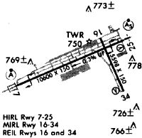
Runways
Runway Summary
| Runways: | 07/25 16/34 |
| Longest Runway: | 07/25 is 10600 ft (3231 m) long |
| Runways with an Instrument Approach: | 07, 25 |
TOL Airport Runway Details
| Runway 07/25 | 10600 ft x 150 ft (3231 m x 46 m) | |
| Runway Length Source: | 3RD PARTY SURVEY as of 07/24/2019 | |
| Surface: | Asphalt - Good condition - Saw-cut or plastic grooved | |
| Runway Pavement Class: | 67 /F/B/W/T | |
| Runway Edge Lights: | High Intensity | |
Runway Weight Bearing Capacity (in thousands of pounds) |
||
| Single Wheel Landing Gear: | 100.0 | |
| Dual Wheel Landing Gear: | 174.0 | |
| Dual Tandem Wheel Landing Gear: | 300.0 | |
| Dual Dual Tandem Wheel Landing Gear: | 550.0 | |
Runway 07 |
Runway 25 |
|
Elevation: |
682.5 | 664.9 |
Latitude: |
41-34-52.9924N | 41-35-33.6199N |
Longitude: |
083-49-50.5224W | 083-47-41.9659W |
|
Runway True Alignment: |
067 | 247 |
ILS Type: |
ILS | ILS/DME |
Glide Path Angle: |
0.0 degrees | 3.0 degrees |
Traffic Pattern: |
Left | Left |
Runway Markings Type: |
Precision Instrument | Precision Instrument |
Runway Markings Condition: |
Good | Good |
Arresting Device: |
BAK-12B | BAK-12B |
Object at End: |
TREES | TREES |
Object Height: |
91 | 75 |
Distance from End: |
4400 | 2600 |
Object Centerline Offset: |
1000 ft. right of centerline | 760 ft. left of centerline |
Visual Glide Slope Indicators: |
4-Light PAPI On Left Side Of Runway | |
Runway Visual Range (RVR): |
Touchdown, Rollout | Touchdown, Rollout |
Approach Light System: |
Standard 2,400 Foot High Intensity Approach Lighting System With Sequenced Flashers, Cat. II or III Config. | 1,400 Foot Medium Intensity Approach Lighting System With Runway Alignment Indicator Lights |
REIL: |
No | No |
Touchdown Lights: |
Yes | No |
Centerline Lights: |
Yes | Yes |
Threshold Crossing Height: |
69 | |
Declared Distances |
||
Take Off Run Avbl. (TORA): |
10599 | 10599 |
Take Off Distance Avbl. (TODA): |
10599 | 10599 |
Actual Stop Dist. Avbl. (ASDA): |
10599 | 10599 |
Landing Dist. Avbl. (LDA): |
10599 | 10599 |
| Runway 16/34 | 5599 ft x 150 ft (1707 m x 46 m) | |
| Runway Length Source: | 3RD PARTY SURVEY as of 07/24/2019 | |
| Surface: | Asphalt - Good condition - Saw-cut or plastic grooved | |
| Runway Pavement Class: | 52 /F/B/W/T | |
| Runway Edge Lights: | Medium Intensity | |
Runway Weight Bearing Capacity (in thousands of pounds) |
||
| Single Wheel Landing Gear: | 100.0 | |
| Dual Wheel Landing Gear: | 174.0 | |
| Dual Tandem Wheel Landing Gear: | 300.0 | |
Runway 16 |
Runway 34 |
|
Elevation: |
674.2 | 664.7 |
Latitude: |
41-35-36.5687N | 41-34-45.5843N |
Longitude: |
083-48-08.2442W | 083-47-39.6750W |
|
Runway True Alignment: |
157 | 337 |
Glide Path Angle: |
3.0 degrees | 3.0 degrees |
Traffic Pattern: |
Left | Left |
Runway Markings Type: |
Nonprecision Instrument | Nonprecision Instrument |
Runway Markings Condition: |
Good | Good |
Object at End: |
TREES | |
Object Height: |
95 | |
Distance from End: |
2740 | |
Object Centerline Offset: |
1000 ft. right of centerline | 760 ft. left of centerline |
Visual Glide Slope Indicators: |
4-Light PAPI On Left Side Of Runway | 4-Light PAPI On Left Side Of Runway |
REIL: |
Yes | Yes |
Touchdown Lights: |
No | No |
Centerline Lights: |
No | No |
Threshold Crossing Height: |
48 | 50 |
Declared Distances |
||
Take Off Run Avbl. (TORA): |
5599 | 5599 |
Take Off Distance Avbl. (TODA): |
5599 | 5599 |
Actual Stop Dist. Avbl. (ASDA): |
5599 | 5599 |
Landing Dist. Avbl. (LDA): |
5599 | 5599 |
Services
Airframe Repair: |
None |
Powerplant Repair: |
None |
Bottled Oxygen: |
None |
Bulk Oxygen: |
None |
Landing Fees: |
No |
Parking: |
Tiedowns available |
Other Services: |
Parachute rental |
Maps & Diagrams
TOL Sectional
Flight Planning
at skyvector.com
at skyvector.com