Location
Latitude: |
31-41-02.0566N (31.683904) |
Longitude: |
083-16-15.2531W (-83.270904) |
Elevation: |
364.8 feet MSL (111 m MSL) |
Magnetic Variation: |
6 W (as of April 2024 from WMM2020 model) |
Time Zone: |
UTC -5.0 (Standard Time) UTC -4.0 (Daylight Savings Time) |
From City: |
02 N.M. SW of Fitzgerald, Georgia |
Found On: |
Jacksonville Chart |
FAA Region: |
ASO |
Contacts
Manager: |
Publicly owned: |
| WILL HAMMOND BOX 963, 125 TERMINAL DRIVE FITZGERALD, GA 31750 229-426-5071 |
CITY OF FITZGERALD & BEN HILL 302 E CENTRAL AVE FITZGERALD, GA 31750 229-426-5060 |
Operations
Airport Status: |
Operational |
Facility Use: |
Public |
Type: |
Airport |
Activation Date: |
10/1945 |
Control tower: |
No |
Attendance (Months/Days/Hours): |
Months/Days/Hours ALL/MON-SAT/0800-1700 |
Boundary ARTCC: |
ZJX (Jacksonville) |
Responsible ARTCC: |
ZJX (Jacksonville) |
Lighting Schedule: |
SEE RMK |
Segmented Circle Indicator: |
Yes |
Traffic Pattern Altitude (MSL): |
1365 feet (416 m) |
NOTAMs Facility: |
MCN |
NOTAM-D Service: |
Yes |
International Airport of Entry: |
No |
Customs Landing Rights: |
No |
Military Landing Rights: |
Yes |
Civil/Military Joint Use: |
No |
Based Aircraft
| Single Engine: | 24 |
| Multi Engine: | 7 |
| Jet Engine: | 1 |
| GA Helicopters: | 2 |
Annual Operations (as of 12/31/2023)
| Total Operations: | 5000 | |
| GA Local: | 2500 | 50.0% |
| GA Itinerant: | 2500 | 50.0% |
Communications
| CTAF: | 123.000 |
| Unicom: | 123.000 |
| AWOS-3: | 118.625 (229-426-5072) |
- APCH/DEP SVC PRVDD BY JACKSONVILLE ARTCC ON FREQS 127.575/269.025 (ALMA RCAG).
Fixed Based Operators (FBOs) & Fuel
(Click on a business for detail)
Please help us keep this information up to date. This is a FREE SERVICE just like everything else on Airport Guide! If you see that a business needs to be added, modified, or deleted please fill out our Update Form.
To add, modify, or delete a business click here.
Please help us keep this information up to date. This is a FREE SERVICE just like everything else on Airport Guide! If you see that a business needs to be added, modified, or deleted please fill out our Update Form.
Area Code: 229 |
| Business Name | Frequency | Phone | Fuel Grade |
|---|---|---|---|
| Fitzgerald Airport Commission
Update FBO info |
Unicom 123.0 | 423-4843 | 100LL, Jet A |
Flight Service Stations
| Primary | Alternate | |
| FSS on Field: | N | |
| FSS Name (ID): | Macon(MCN) | |
| Frequency: | ||
| Toll Free Phone: | 1-800-WX-BRIEF |
Instrument Procedures / Charts
FAA Terminal Procedures valid from 0901Z 03/21/24 to 0901Z 04/18/24.
There are various types of charts available for an airport. They are listed in the Page Type column. Here is a legend for those types:
APD - Airport Diagram
DP - Departure Procedure Charts
HOT - Hot Spots
IAP - Instrument Approach Procedure Charts
MIN - Minimums
STAR - Standard Terminal Arrival Charts
| Page Type | Page Name | Volume | Action Since Last Cycle |
|---|---|---|---|
| IAP | LOC RWY 02 | SE-4 | Changed |
| IAP | NDB RWY 02 | SE-4 | Changed |
| IAP | RNAV (GPS) RWY 02 | SE-4 | Changed |
| MIN | ALTERNATE MINIMUMS | SE-4 | |
| MIN | TAKEOFF MINIMUMS | SE-4 |
Terminal Procedures are only available for airports in several countries with more being added all the time. If you are looking for a specific country's charts, please send an email to support(at)airportguide.com stating the country name. This will be used to prioritize the implementation.
Navigation Aids (Navaids) near KFZG
| Dist (NM) | ID | Morse Code | Name | Type | Freq | True Hdg | Mag Hdg |
|---|---|---|---|---|---|---|---|
| 4.4 | SUR | . . . . . _ . _ . | Fitzgerald | NDB | 362 | 193 | 199 |
| 18.9 | IFM | . . . . _ . _ _ | Tift Myers | VOR | 112.50 | 216 | 222 |
| 21.2 | TM | _ _ _ | Tifto | NDB | 409 | 204 | 210 |
| 24.4 | OWC | _ _ _ . _ _ _ . _ . | Coffee County | NDB | 390 | 133 | 139 |
| 27.5 | EZM | . _ _ . . _ _ | Eastman | NDB | 366 | 12 | 18 |
| 31.7 | MQW | _ _ _ _ . _ . _ _ | Mc Rae | NDB | 280 | 38 | 44 |
| 33.8 | VNA | . . . _ _ . . _ | Vienna | VORTAC | 116.50 | 340 | 346 |
| 33.9 | AZE | . _ _ _ . . . | Hazlehurst | NDB | 414 | 69 | 75 |
| 35.5 | OHY | _ _ _ . . . . _ . _ _ | Coney | NDB | 400 | 302 | 308 |
| 40.0 | AMG | . _ _ _ _ _ . | Alma | VORTAC | 115.10 | 102 | 108 |
| 43.6 | VAD | . . . _ . _ _ . . | Moody | TACAN | 113.30 | 174 | 180 |
| 44.2 | AYS | . _ _ . _ _ . . . | Waycross | VORTAC | 110.20 | 124 | 130 |
| 45.0 | BHC | _ . . . . . . . _ . _ . | Baxley | NDB | 376 | 87 | 93 |
| 45.3 | MGR | _ _ _ _ . . _ . | Moultrie | DME | 108.8 | 217 | 223 |
| 45.6 | HOE | . . . . _ _ _ . | Homerville | NDB | 209 | 145 | 151 |
| 49.6 | AY | . _ _ . _ _ | Wiket | NDB | 219 | 115 | 121 |
| 49.8 | DB | _ . . _ . . . | Creke | NDB | 251 | 15 | 21 |
| 51.8 | LKG | . _ . . _ . _ _ _ . | Lindbergh | NDB | 242 | 304 | 310 |
| 52.1 | GTP | _ _ . _ . _ _ . | Paton | NDB | 245 | 213 | 219 |
| 52.2 | PZD | . _ _ . _ _ . . _ . . | Pecan | VOR-DME | 116.10 | 268 | 274 |
Nearby Airports with Fuel
Notices to Airmen (NOTAMS)
Remarks
| A110-1 | PAEW ADJ RWY 02/20. |
| A110-3 | FOR CD CTC JACKSONVILLE ARTCC AT 904-845-1592. |
| A42-15 | 15/33 THLDS MKD WITH WHITE TIRES. |
| A81-APT | MIRL RWY 02/20 PRESET MED INTST DUSK-2200; AFT 2200 - CTAF. ACTVT ODALS RWY 02; REILS RWY 02; PAPI RWY 02 & 20 - CTAF. |
Runways
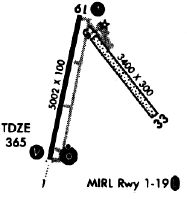
Runway Summary
| Runways: | 02/20 15/33 |
| Longest Runway: | 02/20 is 5000 ft (1524 m) long |
| Runways with an Instrument Approach: | 02 |
KFZG Airport Runway Details
| Runway 02/20 | 5000 ft x 101 ft (1524 m x 31 m) | |
| Runway Length Source: | 3RD PARTY SURVEY as of 11/24/2008 | |
| Surface: | Asphalt - Good condition - No special surface treatment | |
| Runway Edge Lights: | Medium Intensity | |
Runway Weight Bearing Capacity (in thousands of pounds) |
||
| Dual Wheel Landing Gear: | 28.0 | |
Runway 02 |
Runway 20 |
|
Elevation: |
355.4 | 364.3 |
Latitude: |
31-40-35.4710N | 31-41-23.8919N |
Longitude: |
083-16-28.6837W | 083-16-16.7601W |
|
Runway True Alignment: |
012 | 192 |
ILS Type: |
LOCALIZER | |
Glide Path Angle: |
3.0 degrees | 3.0 degrees |
Traffic Pattern: |
Left | Left |
Runway Markings Type: |
Nonprecision Instrument | Nonprecision Instrument |
Runway Markings Condition: |
Good | Good |
Object at End: |
TREES | TREES |
Object Height: |
43 | 35 |
Distance from End: |
802 | 410 |
Object Centerline Offset: |
325 ft. right of centerline | 266 ft. right of centerline |
Visual Glide Slope Indicators: |
2-Light PAPI On Left Side Of Runway | 2-Light PAPI On Left Side Of Runway |
Approach Light System: |
Omnidirectional Approach Lighting System | |
REIL: |
Yes | |
Threshold Crossing Height: |
44 | 47 |
| Runway 15/33 | 2984 ft x 300 ft (910 m x 91 m) | |
| Runway Length Source: | 3RD PARTY SURVEY as of 12/30/2007 | |
| Surface: | Asphalt - Good condition - No special surface treatment | |
Runway 15 |
Runway 33 |
|
Elevation: |
362.1 | 338.5 |
Latitude: |
31-41-17.5083N | 31-40-54.5646N |
Longitude: |
083-16-13.6049W | 083-15-51.8712W |
|
Runway True Alignment: |
141 | 321 |
Glide Path Angle: |
0.0 degrees | 0.0 degrees |
Traffic Pattern: |
Left | Left |
Object at End: |
TREES | TREES |
Object Height: |
78 | 60 |
Distance from End: |
1014 | 360 |
Object Centerline Offset: |
325 ft. right of centerline | 266 ft. right of centerline |
Services
Airframe Repair: |
Minor |
Powerplant Repair: |
Minor |
Bottled Oxygen: |
None |
Bulk Oxygen: |
None |
Fuel Available: |
100LL |
Landing Fees: |
No |
Parking: |
Tiedowns available |
Maps & Diagrams
KFZG Sectional
Flight Planning
at skyvector.com
at skyvector.com