Location
Latitude: |
36-59-34.2000N (36.992833) |
Longitude: |
091-42-52.1000W (-91.714472) |
Elevation: |
1182.0 feet MSL (360 m MSL) |
Magnetic Variation: |
0.7 W (as of May 2024 from WMM2020 model) |
Time Zone: |
UTC -6.0 (Standard Time) UTC -5.0 (Daylight Savings Time) |
From City: |
01 N.M. SW of Mountain View, Missouri |
Found On: |
Kansas City Chart |
FAA Region: |
ACE |
Contacts
Manager: |
Publicly owned: |
| EDDIE OWENS BOX 1090 MOUNTAIN VIEW, MO 65548 (417) 934-2601 |
CITY OF MOUNTAIN VIEW 126 N. OAK, P.O. BOX 1090 MOUNTAIN VIEW, MO 65548 417- 934-2601 |
Operations
Airport Status: |
Operational |
Facility Use: |
Public |
Type: |
Airport |
Activation Date: |
10/1965 |
Control tower: |
No |
Attendance (Months/Days/Hours): |
Months/Days/Hours ALL/ALL/0800-1700 |
Boundary ARTCC: |
ZKC (Kansas City) |
Responsible ARTCC: |
ZKC (Kansas City) |
Lighting Schedule: |
SEE RMK |
Segmented Circle Indicator: |
Yes |
Traffic Pattern Altitude (MSL): |
2182 feet (665 m) |
NOTAMs Facility: |
COU |
NOTAM-D Service: |
Yes |
International Airport of Entry: |
No |
Customs Landing Rights: |
No |
Military Landing Rights: |
Yes |
Civil/Military Joint Use: |
No |
Based Aircraft
| Single Engine: | 12 |
| Multi Engine: | 1 |
Annual Operations (as of 12/31/2021)
| Total Operations: | 2100 | |
| GA Local: | 1200 | 57.1% |
| GA Itinerant: | 900 | 42.9% |
Communications
| CTAF: | 122.800 |
| Unicom: | 122.800 |
- APCH/DEP SVC PRVDD BY KANSAS CITY ARTCC ON FREQS 128.35/284.675 (RICHLAND RCAG).
Fixed Based Operators (FBOs) & Fuel
(Click on a business for detail)
Please help us keep this information up to date. This is a FREE SERVICE just like everything else on Airport Guide! If you see that a business needs to be added, modified, or deleted please fill out our Update Form.
To add, modify, or delete a business click here.
Please help us keep this information up to date. This is a FREE SERVICE just like everything else on Airport Guide! If you see that a business needs to be added, modified, or deleted please fill out our Update Form.
Area Code: 417 |
| Business Name | Frequency | Phone | Fuel Grade |
|---|---|---|---|
| Smith's Flying Service
Update FBO info |
Unicom 122.8 | 934-6252 | 100LL, Jet A, MOGAS |
Flight Service Stations
| Primary | Alternate | |
| FSS on Field: | N | |
| FSS Name (ID): | Columbia(COU) | |
| Frequency: | ||
| Toll Free Phone: | 1-800-WX-BRIEF |
Instrument Procedures / Charts
FAA Terminal Procedures valid from 0901Z 05/16/24 to 0901Z 06/13/24.
There are various types of charts available for an airport. They are listed in the Page Type column. Here is a legend for those types:
APD - Airport Diagram
DP - Departure Procedure Charts
HOT - Hot Spots
IAP - Instrument Approach Procedure Charts
MIN - Minimums
STAR - Standard Terminal Arrival Charts
| Page Type | Page Name | Volume | Action Since Last Cycle |
|---|---|---|---|
| IAP | RNAV (GPS) RWY 10 | NC-3 | |
| IAP | RNAV (GPS) RWY 28 | NC-3 | Changed |
| MIN | TAKEOFF MINIMUMS | NC-3 |
Terminal Procedures are only available for airports in several countries with more being added all the time. If you are looking for a specific country's charts, please send an email to support(at)airportguide.com stating the country name. This will be used to prioritize the implementation.
Navigation Aids (Navaids) near KMNF
| Dist (NM) | ID | Morse Code | Name | Type | Freq | True Hdg | Mag Hdg |
|---|---|---|---|---|---|---|---|
| 0.2 | MNF | _ _ _ . . . _ . | Mountain View | NDB | 365 | 62 | 63 |
| 11.3 | UNO | . . _ _ . _ _ _ | Pomona | NDB | 335 | 232 | 233 |
| 11.5 | HUW | . . . . . . _ . _ _ | Hutton | DME | 111.6 | 230 | 231 |
| 36.1 | MAP | _ _ . _ . _ _ . | Maples | TACAN | 113.40 | 354 | 355 |
| 46.2 | BHN | _ . . . . . . . _ . | Buckhorn | NDB | 391 | 336 | 337 |
| 49.3 | TBN | _ _ . . . _ . | Forney | VOR | 110.00 | 335 | 336 |
| 54.9 | FLP | . . _ . . _ . . . _ _ . | Flippin | DME | 116.05 | 220 | 220 |
| 55.7 | DGD | _ . . _ _ . _ . . | Dogwood | VORTAC | 109.40 | 272 | 272 |
| 56.9 | IEB | . . . _ . . . | Lebanon | NDB | 414 | 307 | 307 |
| 60.6 | TNZ | _ _ . _ _ . . | Lawrence County | NDB | 227 | 140 | 141 |
| 64.4 | ARG | . _ . _ . _ _ . | Walnut Ridge | VORTAC | 114.50 | 145 | 146 |
| 69.3 | FD | . . _ . _ . . | Earli | NDB | 278 | 105 | 106 |
| 69.7 | VIH | . . . _ . . . . . . | Vichy | VOR-DME | 117.70 | 0 | 1 |
| 75.7 | SHY | . . . . . . . _ . _ _ | Sunshine | VOR-DME | 108.40 | 326 | 326 |
| 76.8 | PRI | . _ _ . . _ . . . | Perrine | NDB | 367 | 52 | 53 |
| 77.3 | AIZ | . _ . . _ _ . . | Kaiser | NDB | 377 | 329 | 329 |
| 77.5 | BV | _ . . . . . . _ | Almnd | NDB | 335 | 183 | 184 |
| 79.0 | UUV | . . _ . . _ . . . _ | Sullivan | NDB | 356 | 19 | 20 |
| 80.4 | SGF | . . . _ _ . . . _ . | Springfield | VORTAC | 116.90 | 286 | 286 |
| 81.6 | FAM | . . _ . . _ _ _ | Farmington | VORTAC | 115.70 | 59 | 60 |
Nearby Airports with Fuel
Notices to Airmen (NOTAMS)
Remarks
| A110-1 | WILDLIFE ON & INVOF ARPT. |
| A110-2 | FOR CD CTC KANSAS CITY ARTCC AT 913-254-8508. |
| A16 | 417-247-2203 (MOBILE) AFTER HOURS |
| A17 | AFT HRS PHONE NBRS POSTED ON TERMINAL DOOR. |
| A42-10 | MARKINGS FADED |
| A42-28 | MARKINGS FADED |
| A43-28 | PAPI UNUSBL BYD 4 DEG LEFT OF CNTRLN. |
| A58-10 | 8-12 FT SMALL TREES AND BRUSH 0-200 FT FROM RWY END 110 FT RIGHT AND 130 FT LEFT |
| A70-FUEL-10 | 0LL 100LL AVLBL 24 HRS SELF SERVICE |
| A81-APT | ACTVT MIRL RY 10/28 AND PAPI RY 28 - 122.8 |
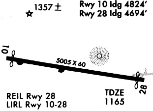
Runways
Runway Summary
| Runways: | 10/28 |
| Longest Runway: | 10/28 is 5005 ft (1526 m) long |
| Runways with an Instrument Approach: |
KMNF Airport Runway Details
| Runway 10/28 | 5005 ft x 75 ft (1526 m x 23 m) | |
| Runway Length Source: | 3RD PARTY SURVEY as of 11/06/2010 | |
| Surface: | Asphalt - Fair condition - No special surface treatment | |
| Runway Edge Lights: | Medium Intensity | |
Runway 10 |
Runway 28 |
|
Elevation: |
1182.0 | 1136.7 |
Latitude: |
36-59-38.1323N | 36-59-30.1957N |
Longitude: |
091-43-22.5096W | 091-42-21.6221W |
|
Runway True Alignment: |
099 | 279 |
Glide Path Angle: |
0.0 degrees | 3.5 degrees |
Traffic Pattern: |
Left | Left |
Runway Markings Type: |
Nonprecision Instrument | Nonprecision Instrument |
Runway Markings Condition: |
Poor | Poor |
Object at End: |
PLINE | POLE |
Object Height: |
37 | 45 |
Distance from End: |
600 | 980 |
Object Centerline Offset: |
197 ft. left of centerline | 250 ft. right of centerline |
Visual Glide Slope Indicators: |
4-Light PAPI On Left Side Of Runway | |
Threshold Crossing Height: |
54 | |
Threshold Elevation: |
1179.0 | |
Displaced Threshold: |
319 | |
Threshold Latitude: |
36-59-37.6289N | |
Threshold Longitude: |
091-43-18.6286W |
Services
Airframe Repair: |
None |
Powerplant Repair: |
None |
Bottled Oxygen: |
None |
Fuel Available: |
100LL |
Landing Fees: |
No |
Parking: |
Hangars and tiedowns available |
Maps & Diagrams
KMNF Sectional
Flight Planning
at skyvector.com
at skyvector.com