Location
Latitude: |
43-14-05.1249N (43.234757) |
Longitude: |
093-37-26.7742W (-93.624104) |
Elevation: |
1229.2 feet MSL (375 m MSL) |
Magnetic Variation: |
0.3 E (as of April 2024 from WMM2020 model) |
Time Zone: |
UTC -6.0 (Standard Time) UTC -5.0 (Daylight Savings Time) |
From City: |
02 N.M. S of Forest City, Iowa |
Found On: |
Omaha Chart |
FAA Region: |
ACE |
Contacts
Manager: |
Publicly owned: |
| R.TRIMBLE MUNICIPAL ARPT, 1842 330TH ST FOREST CITY, IA 50436 641-581-2880 |
CITY OF FOREST CITY 305 N. CLARK FOREST CITY, IA 50436 641-585-3574 |
Operations
Airport Status: |
Operational |
Facility Use: |
Public |
Type: |
Airport |
Activation Date: |
12/1958 |
Control tower: |
No |
Attendance (Months/Days/Hours): |
Months/Days/Hours ALL/MON-FRI/0800-1730 |
Boundary ARTCC: |
ZMP (Minneapolis) |
Responsible ARTCC: |
ZMP (Minneapolis) |
Lighting Schedule: |
SEE RMK |
Segmented Circle Indicator: |
No |
Traffic Pattern Altitude (MSL): |
2229 feet (679 m) |
NOTAMs Facility: |
FOD |
NOTAM-D Service: |
Yes |
International Airport of Entry: |
No |
Customs Landing Rights: |
No |
Military Landing Rights: |
Yes |
Civil/Military Joint Use: |
No |
Based Aircraft
| Single Engine: | 18 |
Annual Operations (as of 06/06/2023)
| Total Operations: | 4000 | |
| GA Local: | 2400 | 60.0% |
| GA Itinerant: | 1600 | 40.0% |
Communications
| CTAF: | 122.800 |
| Unicom: | 122.800 |
| AWOS-3: | 123.925 (641-581-2347) |
- COMMUNICATIONS PRVDD BY FORT DODGE RADIO ON FREQ 122.6 (MASON CITY RCO).
- APCH/DEP SVC PRVDD BY MINNEAPOLIS ARTCC ON FREQS 127.3/257.675 (MASON CITY RCAG).
Fixed Based Operators (FBOs) & Fuel
(Click on a business for detail)
Please help us keep this information up to date. This is a FREE SERVICE just like everything else on Airport Guide! If you see that a business needs to be added, modified, or deleted please fill out our Update Form.
To add, modify, or delete a business click here.
Please help us keep this information up to date. This is a FREE SERVICE just like everything else on Airport Guide! If you see that a business needs to be added, modified, or deleted please fill out our Update Form.
Area Code: 641 |
| Business Name | Frequency | Phone | Fuel Grade |
|---|
Flight Service Stations
| Primary | Alternate | |
| FSS on Field: | N | |
| FSS Name (ID): | Fort Dodge(FOD) | |
| Frequency: | ||
| Toll Free Phone: | 1-800-WX-BRIEF |
Instrument Procedures / Charts
FAA Terminal Procedures valid from 0901Z 03/21/24 to 0901Z 04/18/24.
There are various types of charts available for an airport. They are listed in the Page Type column. Here is a legend for those types:
APD - Airport Diagram
DP - Departure Procedure Charts
HOT - Hot Spots
IAP - Instrument Approach Procedure Charts
MIN - Minimums
STAR - Standard Terminal Arrival Charts
| Page Type | Page Name | Volume | Action Since Last Cycle |
|---|---|---|---|
| IAP | RNAV (GPS) RWY 15 | NC-3 | |
| IAP | RNAV (GPS) RWY 33 | NC-3 | Changed |
| IAP | VOR-A | NC-3 | |
| MIN | ALTERNATE MINIMUMS | NC-3 | |
| MIN | TAKEOFF MINIMUMS | NC-3 |
Terminal Procedures are only available for airports in several countries with more being added all the time. If you are looking for a specific country's charts, please send an email to support(at)airportguide.com stating the country name. This will be used to prioritize the implementation.
Navigation Aids (Navaids) near FXY
| Dist (NM) | ID | Morse Code | Name | Type | Freq | True Hdg | Mag Hdg |
|---|---|---|---|---|---|---|---|
| 0.2 | FXY | . . _ . _ . . _ _ . _ _ | Forest City | NDB | 359 | 66 | 66 |
| 15.4 | MCW | _ _ _ . _ . . _ _ | Mason City | VOR-DME | 114.90 | 123 | 123 |
| 17.0 | MC | _ _ _ . _ . | Surff | NDB | 348 | 130 | 130 |
| 29.0 | AEL | . _ . . _ . . | Albert Lea | VOR-DME | 109.80 | 22 | 22 |
| 29.8 | AXA | . _ _ . . _ . _ | Algona | NDB | 403 | 252 | 251 |
| 29.9 | SBU | . . . _ . . . . . _ | Blue Earth | NDB | 332 | 316 | 316 |
| 30.0 | CAV | _ . _ . . _ . . . _ | Clarion | NDB | 387 | 191 | 191 |
| 36.4 | FQ | . . _ . _ _ . _ | Montz | NDB | 420 | 304 | 303 |
| 37.0 | JAY | . _ _ _ . _ _ . _ _ | Austin | VOR-DME | 108.20 | 56 | 56 |
| 39.7 | IY | . . _ . _ _ | Chukk | NDB | 417 | 98 | 98 |
| 42.0 | FNX | . . _ . _ . _ . . _ | Fairmont | DME | 114.25 | 305 | 304 |
| 42.6 | FRM | . . _ . . _ . _ _ | Fairmont | DME | 110.2 | 305 | 304 |
| 45.6 | CCY | _ . _ . _ . _ . _ . _ _ | Charles City | NDB | 375 | 102 | 102 |
| 47.6 | FOD | . . _ . _ _ _ _ . . | Fort Dodge | TACAN | 113.50 | 218 | 217 |
| 48.1 | EGQ | . _ _ . _ _ . _ | Emmetsburg | NDB | 410 | 260 | 259 |
| 48.8 | EBS | . _ . . . . . . | Webster City | NDB | 323 | 192 | 192 |
| 49.1 | PUF | . _ _ . . . _ . . _ . | Puff | NDB | 345 | 278 | 277 |
| 50.0 | EST | . . . . _ | Estherville | VOR | 110.40 | 282 | 281 |
| 52.6 | FO | . . _ . _ _ _ | Barro | NDB | 341 | 214 | 213 |
| 53.7 | POH | . _ _ . _ _ _ . . . . | Pocahontas | NDB | 428 | 237 | 236 |
Nearby Airports with Fuel
Notices to Airmen (NOTAMS)
Remarks
| A110-1 | FOR CD CTC MINNEAPOLIS ARTCC AT 651-463-5588. |
| A16 | RESIDENCE - 641-585-2166. |
| A17 | FOR SVC AFTER HRS & WEEKENDS CALL (641) 585-2166 OR (641) 590-2127 |
| A51-15 | 34:1 TO DISPLACED THRESHOLD |
| A81-APT | ACTVT MIRL RYS 09/27 & 15/33; PAPI RYS 15 & 33 & REIL RYS 15 & 33 - CTAF. |
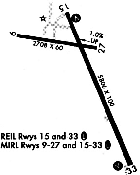
Runways
Runway Summary
| Runways: | 09/27 15/33 |
| Longest Runway: | 15/33 is 5796 ft (1767 m) long |
| Runways with an Instrument Approach: |
FXY Airport Runway Details
| Runway 09/27 | 2707 ft x 60 ft (825 m x 18 m) | |
| Surface: | Asphalt - Good condition - No special surface treatment | |
| Runway Pavement Class: | 4 /F/C/X/U | |
| Runway Edge Lights: | Medium Intensity | |
Runway Weight Bearing Capacity (in thousands of pounds) |
||
| Single Wheel Landing Gear: | 12.5 | |
Runway 09 |
Runway 27 |
|
Elevation: |
1229.2 | 1203.4 |
Latitude: |
43-14-16.4298N | 43-14-14.2504N |
Longitude: |
093-37-58.7955W | 093-37-22.3504W |
|
Runway True Alignment: |
095 | 275 |
Glide Path Angle: |
0.0 degrees | 0.0 degrees |
Traffic Pattern: |
Left | |
Runway Markings Type: |
Basic | Basic |
Runway Markings Condition: |
Fair | Fair |
Object at End: |
TREE | TREE |
Object Height: |
34 | 11 |
Distance from End: |
645 | 231 |
Object Centerline Offset: |
121 ft. left of centerline | 49 ft. right of centerline |
| Runway 15/33 | 5796 ft x 100 ft (1767 m x 30 m) | |
| Runway Length Source: | 3RD PARTY SURVEY as of 06/08/2007 | |
| Surface: | Asphalt - Good condition - No special surface treatment | |
| Runway Edge Lights: | Medium Intensity | |
Runway Weight Bearing Capacity (in thousands of pounds) |
||
| Single Wheel Landing Gear: | 30.0 | |
Runway 15 |
Runway 33 |
|
Elevation: |
1206.7 | 1202.8 |
Latitude: |
43-14-26.2760N | 43-13-34.4472N |
Longitude: |
093-37-36.9720W | 093-37-03.7064W |
|
Runway True Alignment: |
155 | 335 |
Glide Path Angle: |
3.0 degrees | 3.0 degrees |
Traffic Pattern: |
Left | Left |
Runway Markings Type: |
Nonprecision Instrument | Nonprecision Instrument |
Runway Markings Condition: |
Good | Good |
Object at End: |
TREES | FENCE |
Object Height: |
39 | 5 |
Distance from End: |
750 | 315 |
Object Centerline Offset: |
121 ft. left of centerline | 49 ft. right of centerline |
Visual Glide Slope Indicators: |
2-Light PAPI On Left Side Of Runway | 2-Light PAPI On Left Side Of Runway |
REIL: |
Yes | Yes |
Threshold Crossing Height: |
28 | 40 |
Threshold Elevation: |
1204.3 | |
Displaced Threshold: |
600 | |
Threshold Latitude: |
43-14-20.9070N | |
Threshold Longitude: |
093-37-33.5250W |
Services
Airframe Repair: |
Major |
Powerplant Repair: |
Major |
Bottled Oxygen: |
High Pressure / Low Pressure |
Bulk Oxygen: |
None |
Fuel Available: |
100LL |
Landing Fees: |
No |
Parking: |
Hangars and tiedowns available |
Maps & Diagrams
FXY Sectional
Flight Planning
at skyvector.com
at skyvector.com