Location
Latitude: |
42-42-35.7000N (42.709917) |
Longitude: |
093-54-58.0000W (-93.916111) |
Elevation: |
1132.3 feet MSL (345 m MSL) |
Magnetic Variation: |
0.6 E (as of April 2024 from WMM2020 model) |
Time Zone: |
UTC -6.0 (Standard Time) UTC -5.0 (Daylight Savings Time) |
From City: |
03 N.M. N of Eagle Grove, Iowa |
Found On: |
Omaha Chart |
FAA Region: |
ACE |
Contacts
Manager: |
Publicly owned: |
| BRYCE DAVIS 2355 HWY 17 EAGLE GROVE, IA 50533 515-851-5826 |
CITY OF EAGLE GROVE 210 EAST BROADWAY EAGLE GROVE, IA 50533 515-448-4343 |
Operations
Airport Status: |
Operational |
Facility Use: |
Public |
Type: |
Airport |
Activation Date: |
11/1948 |
Control tower: |
No |
Attendance (Months/Days/Hours): |
Months/Days/Hours Unattended |
Boundary ARTCC: |
ZMP (Minneapolis) |
Responsible ARTCC: |
ZMP (Minneapolis) |
Lighting Schedule: |
SEE RMK |
Segmented Circle Indicator: |
No |
Traffic Pattern Altitude (MSL): |
2132 feet (650 m) |
NOTAMs Facility: |
FOD |
NOTAM-D Service: |
Yes |
International Airport of Entry: |
No |
Customs Landing Rights: |
No |
Military Landing Rights: |
No |
Civil/Military Joint Use: |
No |
Based Aircraft
| Single Engine: | 7 |
| Multi Engine: | 1 |
Annual Operations (as of 05/10/2019)
| Total Operations: | 2000 | |
| GA Local: | 1114 | 55.7% |
| GA Itinerant: | 886 | 44.3% |
Communications
| CTAF: | 122.800 |
| Unicom: | 122.800 |
- APCH/DEP SVC PRVDD BY MINNEAPOLIS ARTCC ON FREQS 134.0/288.3 (FORT DODGE RCAG).
Fixed Based Operators (FBOs) & Fuel
(Click on a business for detail)
Please help us keep this information up to date. This is a FREE SERVICE just like everything else on Airport Guide! If you see that a business needs to be added, modified, or deleted please fill out our Update Form.
To add, modify, or delete a business click here.
Please help us keep this information up to date. This is a FREE SERVICE just like everything else on Airport Guide! If you see that a business needs to be added, modified, or deleted please fill out our Update Form.
Area Code: 515 |
| Business Name | Frequency | Phone | Fuel Grade |
|---|---|---|---|
| Eagle Air and Repair, Inc.
Update FBO info |
448-4042 | 100LL |
Flight Service Stations
| Primary | Alternate | |
| FSS on Field: | N | |
| FSS Name (ID): | Fort Dodge(FOD) | |
| Frequency: | ||
| Toll Free Phone: | 1-800-WX-BRIEF |
Instrument Procedures / Charts
FAA Terminal Procedures valid from 0901Z 03/21/24 to 0901Z 04/18/24.
There are various types of charts available for an airport. They are listed in the Page Type column. Here is a legend for those types:
APD - Airport Diagram
DP - Departure Procedure Charts
HOT - Hot Spots
IAP - Instrument Approach Procedure Charts
MIN - Minimums
STAR - Standard Terminal Arrival Charts
| Page Type | Page Name | Volume | Action Since Last Cycle |
|---|---|---|---|
| IAP | RNAV (GPS) RWY 13 | NC-3 | |
| IAP | RNAV (GPS) RWY 31 | NC-3 | |
| MIN | TAKEOFF MINIMUMS | NC-3 |
Terminal Procedures are only available for airports in several countries with more being added all the time. If you are looking for a specific country's charts, please send an email to support(at)airportguide.com stating the country name. This will be used to prioritize the implementation.
Navigation Aids (Navaids) near KEAG
| Dist (NM) | ID | Morse Code | Name | Type | Freq | True Hdg | Mag Hdg |
|---|---|---|---|---|---|---|---|
| 7.2 | CAV | _ . _ . . _ . . . _ | Clarion | NDB | 387 | 72 | 71 |
| 16.2 | EBS | . _ . . . . . . | Webster City | NDB | 323 | 172 | 171 |
| 17.7 | FOD | . . _ . _ _ _ _ . . | Fort Dodge | TACAN | 113.50 | 250 | 249 |
| 20.8 | FO | . . _ . _ _ _ | Barro | NDB | 341 | 235 | 234 |
| 27.2 | AXA | . _ _ . . _ . _ | Algona | NDB | 403 | 325 | 324 |
| 32.4 | POH | . _ _ . _ _ _ . . . . | Pocahontas | NDB | 428 | 274 | 273 |
| 33.0 | MC | _ _ _ . _ . | Surff | NDB | 348 | 51 | 51 |
| 34.1 | FXY | . . _ . _ . . _ _ . _ _ | Forest City | NDB | 359 | 22 | 22 |
| 34.6 | MCW | _ _ _ . _ . . _ _ | Mason City | VOR-DME | 114.90 | 47 | 47 |
| 42.0 | EGQ | . _ _ . _ _ . _ | Emmetsburg | NDB | 410 | 304 | 303 |
| 45.9 | EFW | . . . _ . . _ _ | Jefferson | NDB | 391 | 204 | 203 |
| 49.7 | EE | . . | Merle | NDB | 362 | 166 | 166 |
| 51.1 | SKI | . . . _ . _ . . | Sac City | NDB | 356 | 247 | 246 |
| 52.7 | PUF | . _ _ . . . _ . . _ . | Puff | NDB | 345 | 317 | 316 |
| 53.8 | SBU | . . . _ . . . . . _ | Blue Earth | NDB | 332 | 351 | 350 |
| 54.7 | FQ | . . _ . _ _ . _ | Montz | NDB | 420 | 341 | 340 |
| 55.5 | EST | . . . . _ | Estherville | VOR | 110.40 | 319 | 318 |
| 57.3 | JWJ | . _ _ _ . _ _ . _ _ _ | Elmwood | DME | 109.4 | 128 | 128 |
| 58.1 | IY | . . _ . _ _ | Chukk | NDB | 417 | 63 | 63 |
| 59.0 | SLB | . . . . _ . . _ . . . | Storm Lake | NDB | 434 | 264 | 263 |
Nearby Airports with Fuel
Notices to Airmen (NOTAMS)
Remarks
| A11 | DON GARRETT ARPT CMSN CHMN; PHONE 515-448-4073. |
| A110-1 | FOR CD CTC MINNEAPOLIS ARTCC AT 651-463-5588. |
| A30-01/19 | CLSD NOV-APR. |
| A42-01 | 01/19 MKD WITH YELLOW CONES. |
| A48-13 | REIL OTS INDEFLY. |
| A57-13 | DSPLCD THR ALLOWS A 20:1 CLNC OVER ROAD. |
| A58-13 | +15 ROAD 184' FM THR 120' R. |
| A81-APT | ACTVT MIRL RY 13/31 & REIL RYS 13 & 31 - CTAF. |
| E111 | ESTABD PRIOR TO 1959. |
Runways
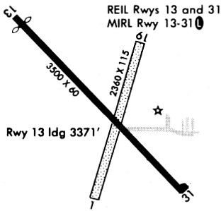
Runway Summary
| Runways: | 01/19 13/31 |
| Longest Runway: | 13/31 is 3500 ft (1067 m) long |
| Runways with an Instrument Approach: |
KEAG Airport Runway Details
| Runway 01/19 | 2389 ft x 120 ft (728 m x 37 m) | |
| Runway Length Source: | 3RD PARTY SURVEY as of 08/07/2011 | |
| Surface: | Turf - Fair condition - No special surface treatment | |
Runway 01 |
Runway 19 |
|
Elevation: |
1128.8 | 1128.0 |
Latitude: |
42-42-23.3484N | 42-42-45.9857N |
Longitude: |
093-55-00.2738W | 093-54-51.2648W |
|
Runway True Alignment: |
016 | 196 |
Glide Path Angle: |
0.0 degrees | 0.0 degrees |
Traffic Pattern: |
Left | Left |
Object at End: |
BRUSH | |
Object Height: |
5 | |
Distance from End: |
110 | |
Object Centerline Offset: |
60 ft. right of centerline |
| Runway 13/31 | 3500 ft x 60 ft (1067 m x 18 m) | |
| Runway Length Source: | 3RD PARTY SURVEY as of 08/07/2011 | |
| Surface: | Turf - Fair condition - No special surface treatment | |
| Runway Edge Lights: | Medium Intensity | |
Runway 13 |
Runway 31 |
|
Elevation: |
1130.9 | 1128.6 |
Latitude: |
42-42-48.9195N | 42-42-23.8929N |
Longitude: |
093-55-15.7752W | 093-54-43.4271W |
|
Runway True Alignment: |
136 | 316 |
Glide Path Angle: |
0.0 degrees | 0.0 degrees |
Traffic Pattern: |
Left | Left |
Runway Markings Type: |
Nonprecision Instrument | Nonprecision Instrument |
Runway Markings Condition: |
Fair | Fair |
Object at End: |
ROAD | TREE |
Object Height: |
15 | 46 |
Distance from End: |
200 | 1429 |
Object Centerline Offset: |
60 ft. right of centerline | |
REIL: |
Yes | Yes |
Threshold Elevation: |
1130.9 | |
Displaced Threshold: |
119 | |
Threshold Latitude: |
42-42-48.0686N | |
Threshold Longitude: |
093-55-14.6751W |
Services
Airframe Repair: |
Major |
Powerplant Repair: |
Major |
Bottled Oxygen: |
None |
Bulk Oxygen: |
None |
Fuel Available: |
100, Jet A |
Landing Fees: |
No |
Parking: |
Hangars and tiedowns available |
Maps & Diagrams
KEAG Sectional
Flight Planning
at skyvector.com
at skyvector.com