Location
Latitude: |
32-57-14.2000N (32.953944) |
Longitude: |
103-24-31.6000W (-103.408778) |
Elevation: |
3979.2 feet MSL (1213 m MSL) |
Magnetic Variation: |
6.3 E (as of May 2024 from WMM2020 model) |
Time Zone: |
UTC -7.0 (Standard Time) UTC -6.0 (Daylight Savings Time) |
From City: |
03 N.M. W of Lovington, New Mexico |
Found On: |
Albuquerque Chart |
FAA Region: |
ASW |
Contacts
Manager: |
Publicly owned: |
| COREY NEEDHAM PO BOX 1106 HOBBS, NM 88241-1106 575-391-2934 |
LEA COUNTY PO BOX 1106 HOBBS, NM 88241-1106 575-391-2934 |
Operations
Airport Status: |
Operational |
Facility Use: |
Public |
Type: |
Airport |
Activation Date: |
03/1957 |
Control tower: |
No |
Attendance (Months/Days/Hours): |
Months/Days/Hours Unattended |
Boundary ARTCC: |
ZFW (Fort Worth) |
Responsible ARTCC: |
ZFW (Fort Worth) |
Lighting Schedule: |
SEE RMK |
Segmented Circle Indicator: |
Yes |
Traffic Pattern Altitude (MSL): |
4979 feet (1518 m) |
NOTAMs Facility: |
ABQ |
NOTAM-D Service: |
Yes |
International Airport of Entry: |
No |
Customs Landing Rights: |
No |
Military Landing Rights: |
Yes |
Civil/Military Joint Use: |
No |
Based Aircraft
| Single Engine: | 10 |
| Multi Engine: | 1 |
| Gliders: | 1 |
Annual Operations (as of 03/31/2023)
| Total Operations: | 4600 | |
| GA Local: | 1100 | 23.9% |
| GA Itinerant: | 1100 | 23.9% |
| Military Aircraft: | 2400 | 52.2% |
Communications
| CTAF: | 122.800 |
| Unicom: | 122.800 |
- APCH/DEP CTL SVC PRVDD BY FORT WORTH ARTCC (ZFW) ON FREQS 133.1/298.95 (HOBBS RCAG).
Fixed Based Operators (FBOs) & Fuel
(Click on a business for detail)
Please help us keep this information up to date. This is a FREE SERVICE just like everything else on Airport Guide! If you see that a business needs to be added, modified, or deleted please fill out our Update Form.
To add, modify, or delete a business click here.
Please help us keep this information up to date. This is a FREE SERVICE just like everything else on Airport Guide! If you see that a business needs to be added, modified, or deleted please fill out our Update Form.
Area Code: 505 |
| Business Name | Frequency | Phone | Fuel Grade |
|---|
Flight Service Stations
| Primary | Alternate | |
| FSS on Field: | N | |
| FSS Name (ID): | Albuquerque(ABQ) | |
| Frequency: | ||
| Toll Free Phone: | 1-800-WX-BRIEF |
Instrument Procedures / Charts
FAA Terminal Procedures valid from 0901Z 03/21/24 to 0901Z 04/18/24.
There are various types of charts available for an airport. They are listed in the Page Type column. Here is a legend for those types:
APD - Airport Diagram
DP - Departure Procedure Charts
HOT - Hot Spots
IAP - Instrument Approach Procedure Charts
MIN - Minimums
STAR - Standard Terminal Arrival Charts
| Page Type | Page Name | Volume | Action Since Last Cycle |
|---|---|---|---|
| APD | AIRPORT DIAGRAM | SW-1 | |
| IAP | RNAV (GPS) RWY 03 | SW-1 | |
| IAP | RNAV (GPS) RWY 21 | SW-1 | |
| MIN | TAKEOFF MINIMUMS | SW-1 |
Terminal Procedures are only available for airports in several countries with more being added all the time. If you are looking for a specific country's charts, please send an email to support(at)airportguide.com stating the country name. This will be used to prioritize the implementation.
Navigation Aids (Navaids) near E06
| Dist (NM) | ID | Morse Code | Name | Type | Freq | True Hdg | Mag Hdg |
|---|---|---|---|---|---|---|---|
| 20.2 | HOB | . . . . _ _ _ _ . . . | Hobbs | VORTAC | 111.00 | 159 | 153 |
| 42.0 | GNC | _ _ . _ . _ . _ . | Gaines County | NDB | 344 | 113 | 107 |
| 53.3 | ATS | . _ _ . . . | Artesia | NDB | 414 | 263 | 256 |
| 57.5 | RO | . _ . _ _ _ | Topan | NDB | 305 | 295 | 288 |
| 58.8 | CNM | _ . _ . _ . _ _ | Carlsbad | VORTAC | 116.30 | 224 | 218 |
| 62.5 | CV | _ . _ . . . . _ | Carlz | NDB | 402 | 228 | 222 |
| 63.2 | LLN | . _ . . . _ . . _ . | Levelland | NDB | 266 | 54 | 48 |
| 65.1 | CME | _ . _ . _ _ . | Chisum | VORTAC | 116.10 | 291 | 284 |
| 65.3 | INK | . . _ . _ . _ | Wink | VORTAC | 112.10 | 172 | 166 |
| 76.1 | LSA | . _ . . . . . . _ | Lamesa | NDB | 338 | 98 | 92 |
| 77.3 | LIU | . _ . . . . . . _ | Littlefield | NDB | 212 | 41 | 35 |
| 79.8 | MA | _ _ . _ | Farly | NDB | 326 | 136 | 130 |
| 83.8 | MAF | _ _ . _ . . _ . | Midland | VORTAC | 114.80 | 132 | 126 |
| 84.6 | CV | _ . _ . . . . _ | Hisan | NDB | 335 | 7 | 1 |
| 85.7 | CVS | _ . _ . . . . _ . . . | Cannon | TACAN | 111.60 | 2 | 356 |
| 86.2 | MAF | _ _ . _ . . _ . | Midland | VOT | 108.20 | 134 | 128 |
| 87.4 | LBB | . _ . . _ . . . _ . . . | Lubbock | VORTAC | 109.20 | 58 | 52 |
| 89.5 | PEQ | . _ _ . . _ _ . _ | Pecos | VOR-DME | 116.50 | 185 | 179 |
| 94.6 | LD | . _ . . _ . . | Lubbi | NDB | 272 | 62 | 56 |
| 96.7 | TXO | _ _ . . _ _ _ _ | Texico | VORTAC | 112.20 | 16 | 10 |
Nearby Airports with Fuel
Notices to Airmen (NOTAMS)
Remarks
| A110-1 | OIL DRILLING ACT ON & INVOF ARPT. |
| A110-5 | EMERG - 575-396-3611. |
| A110-6 | GATE CODE - 1228# |
| A110-7 | FOR CD CTC FORT WORTH ARTCC AT 817-858-7584. |
| A30A-03 | +3 FT PIPES 700 FT FM THR 60 FT R OF CNTRLN. |
| A43-03 | UNUSBL BYD 9 DEGS RIGHT & LEFT OF CNTRLN. |
| A43-21 | UNUSBL BYD 8 DEG RIGHT OF CNTRLN. |
| A43-30 | UNUSBL BYD 8 DEG RIGHT OF CNTRLN. |
| A81-APT | DUSK-DAWN: MIRL RWY 03/21 & 12/30 PRESET LOW INTST; INCR INTST - CTAF. ACTVT PAPI RWY 03, 12, 21 & 30; MIRL RWY 03/21 & 12/30 - CTAF. |
Runways
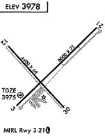
Runway Summary
| Runways: | 03/21 12/30 |
| Longest Runway: | 03/21 is 6001 ft (1829 m) long |
| Runways with an Instrument Approach: |
E06 Airport Runway Details
| Runway 03/21 | 6001 ft x 75 ft (1829 m x 23 m) | |
| Runway Length Source: | 3RD PARTY SURVEY as of 05/01/2010 | |
| Surface: | Asphalt - Good condition - No special surface treatment | |
| Runway Pavement Class: | 5 /F/B/Y/T | |
| Runway Edge Lights: | Medium Intensity | |
Runway Weight Bearing Capacity (in thousands of pounds) |
||
| Single Wheel Landing Gear: | 12.0 | |
Runway 03 |
Runway 21 |
|
Elevation: |
3976.2 | 3966.5 |
Latitude: |
32-56-55.3806N | 32-57-37.3786N |
Longitude: |
103-24-51.7638W | 103-24-01.9939W |
|
Runway True Alignment: |
045 | 225 |
Glide Path Angle: |
3.0 degrees | 3.0 degrees |
Traffic Pattern: |
Left | Left |
Runway Markings Type: |
Nonprecision Instrument | Nonprecision Instrument |
Runway Markings Condition: |
Good | Good |
Visual Glide Slope Indicators: |
2-Light PAPI On Left Side Of Runway | 2-Light PAPI On Left Side Of Runway |
Threshold Crossing Height: |
43 | 43 |
| Runway 12/30 | 4409 ft x 60 ft (1344 m x 18 m) | |
| Runway Length Source: | 3RD PARTY SURVEY as of 05/01/2010 | |
| Surface: | Asphalt - Good condition - No special surface treatment | |
| Runway Pavement Class: | 3 /F/D/Y/T | |
| Runway Edge Lights: | Medium Intensity | |
Runway Weight Bearing Capacity (in thousands of pounds) |
||
| Single Wheel Landing Gear: | 12.0 | |
Runway 12 |
Runway 30 |
|
Elevation: |
3979.2 | 3969.5 |
Latitude: |
32-57-27.4678N | 32-56-55.0306N |
Longitude: |
103-24-55.2270W | 103-24-20.6416W |
|
Runway True Alignment: |
138 | 318 |
Glide Path Angle: |
3.0 degrees | 3.0 degrees |
Traffic Pattern: |
Left | Left |
Runway Markings Type: |
Basic | Basic |
Runway Markings Condition: |
Good | Good |
Visual Glide Slope Indicators: |
2-Light PAPI On Left Side Of Runway | 2-Light PAPI On Left Side Of Runway |
Threshold Crossing Height: |
43 | 43 |
Services
Airframe Repair: |
Minor |
Powerplant Repair: |
Major |
Fuel Available: |
100LL, MOGAS |
Landing Fees: |
No |
Parking: |
Hangars and tiedowns available |
Maps & Diagrams
E06 Sectional
Flight Planning
at skyvector.com
at skyvector.com