Location
Latitude: |
32-41-15.0000N (32.6875) |
Longitude: |
103-13-02.4000W (-103.217333) |
Elevation: |
3660.7 feet MSL (1116 m MSL) |
Magnetic Variation: |
6.2 E (as of May 2024 from WMM2020 model) |
Time Zone: |
UTC -7.0 (Standard Time) UTC -6.0 (Daylight Savings Time) |
From City: |
04 N.M. W of Hobbs, New Mexico |
Found On: |
Albuquerque Chart |
FAA Region: |
ASW |
Contacts
Manager: |
Publicly owned: |
| COREY NEEDHAM 100 N. MAIN, COURTHHOUSE BOX 5C LOVINGTON, NM 88260 575-391-2934 |
LEA COUNTY COURTHOUSE BOX 5C LOVINGTON, NM 88260 575-396-8521 |
Operations
Airport Status: |
Operational |
Facility Use: |
Public |
Type: |
Airport |
Activation Date: |
06/1942 |
Control tower: |
Yes |
Attendance (Months/Days/Hours): |
Months/Days/Hours ALL/ALL/0600-1700 |
Boundary ARTCC: |
ZFW (Fort Worth) |
Responsible ARTCC: |
ZFW (Fort Worth) |
Lighting Schedule: |
SEE RMK |
Segmented Circle Indicator: |
Yes |
Traffic Pattern Altitude (MSL): |
4661 feet (1421 m) |
NOTAMs Facility: |
HOB |
NOTAM-D Service: |
Yes |
International Airport of Entry: |
No |
Customs Landing Rights: |
No |
Military Landing Rights: |
Yes |
Civil/Military Joint Use: |
No |
Aircraft Rescue and Firefighting: |
Class I ARFF Index: A Air Carrier Service: Scheduled Certification Date: 06/2012 |
Based Aircraft
| Single Engine: | 51 |
| Multi Engine: | 3 |
| Jet Engine: | 2 |
| GA Helicopters: | 1 |
Annual Operations (as of 10/31/2023)
| Total Operations: | 8856 | |
| Commercial: | 1 | 0.0% |
| Air Taxi: | 1556 | 17.6% |
| GA Local: | 1331 | 15.0% |
| GA Itinerant: | 5298 | 59.8% |
| Military Aircraft: | 670 | 7.6% |
Communications
| CTAF: | 120.650 |
| Unicom: | 122.950 |
| Tower: | HOBBS 120.65 317.4 Hrs: 0600-1800 |
| Ground: | 121.9 |
| Approach: | FORT WORTH ARTCC |
| Departure: | FORT WORTH ARTCC |
| ATIS: | 119.75 Hrs: 24 |
| AWOS-3: | (575-393-8418) |
| EMERG: | 121.5 |
| EMERG: | 243.0 |
- APCH/DEP CTL SVC PRVDD BY FORT WORTH ARTCC (ZFW) ON FREQS 133.1/298.95 (HOBBS RCAG).
- ATCT OPERATED BY MIDWEST ATC SERVICES INC.
Fixed Based Operators (FBOs) & Fuel
(Click on a business for detail)
Please help us keep this information up to date. This is a FREE SERVICE just like everything else on Airport Guide! If you see that a business needs to be added, modified, or deleted please fill out our Update Form.
To add, modify, or delete a business click here.
Please help us keep this information up to date. This is a FREE SERVICE just like everything else on Airport Guide! If you see that a business needs to be added, modified, or deleted please fill out our Update Form.
Area Code: 505 |
| Business Name | Frequency | Phone | Fuel Grade |
|---|---|---|---|
| Phillips International Aircraft, Inc.
Update FBO info |
Unicom 123.0 | 397-1747 | 100LL, Jet A |
Flight Service Stations
| Primary | Alternate | |
| FSS on Field: | N | |
| FSS Name (ID): | Albuquerque(ABQ) | |
| Frequency: | ||
| Toll Free Phone: | 1-800-WX-BRIEF |
Instrument Procedures / Charts
FAA Terminal Procedures valid from 0901Z 05/16/24 to 0901Z 06/13/24.
There are various types of charts available for an airport. They are listed in the Page Type column. Here is a legend for those types:
APD - Airport Diagram
DP - Departure Procedure Charts
HOT - Hot Spots
IAP - Instrument Approach Procedure Charts
MIN - Minimums
STAR - Standard Terminal Arrival Charts
| Page Type | Page Name | Volume | Action Since Last Cycle |
|---|---|---|---|
| APD | AIRPORT DIAGRAM | SW-1 | |
| IAP | ILS OR LOC RWY 03 | SW-1 | |
| IAP | RNAV (GPS) RWY 03 | SW-1 | |
| IAP | RNAV (GPS) RWY 21 | SW-1 | |
| IAP | RNAV (GPS) RWY 30 | SW-1 | |
| IAP | VOR OR TACAN RWY 21 | SW-1 | |
| MIN | ALTERNATE MINIMUMS | SW-1 | |
| MIN | TAKEOFF MINIMUMS | SW-1 |
Terminal Procedures are only available for airports in several countries with more being added all the time. If you are looking for a specific country's charts, please send an email to support(at)airportguide.com stating the country name. This will be used to prioritize the implementation.
Navigation Aids (Navaids) near HOB
| Dist (NM) | ID | Morse Code | Name | Type | Freq | True Hdg | Mag Hdg |
|---|---|---|---|---|---|---|---|
| 4.0 | HOB | . . . . _ _ _ _ . . . | Hobbs | VORTAC | 111.00 | 221 | 215 |
| 28.9 | GNC | _ _ . _ . _ . _ . | Gaines County | NDB | 344 | 91 | 85 |
| 48.8 | INK | . . _ . _ . _ | Wink | VORTAC | 112.10 | 181 | 175 |
| 57.2 | CNM | _ . _ . _ . _ _ | Carlsbad | VORTAC | 116.30 | 243 | 237 |
| 61.7 | MA | _ _ . _ | Farly | NDB | 326 | 132 | 126 |
| 62.1 | CV | _ . _ . . . . _ | Carlz | NDB | 402 | 246 | 240 |
| 63.5 | ATS | . _ _ . . . | Artesia | NDB | 414 | 279 | 273 |
| 65.8 | LSA | . _ . . . . . . _ | Lamesa | NDB | 338 | 85 | 79 |
| 66.1 | MAF | _ _ . _ . . _ . | Midland | VORTAC | 114.80 | 127 | 121 |
| 67.1 | LLN | . _ . . . _ . . _ . | Levelland | NDB | 266 | 38 | 32 |
| 68.2 | MAF | _ _ . _ . . _ . | Midland | VOT | 108.20 | 130 | 124 |
| 73.8 | RO | . _ . _ _ _ | Topan | NDB | 305 | 303 | 297 |
| 75.3 | PEQ | . _ _ . . _ _ . _ | Pecos | VOR-DME | 116.50 | 194 | 188 |
| 80.7 | CME | _ . _ . _ _ . | Chisum | VORTAC | 116.10 | 299 | 292 |
| 84.8 | LIU | . _ . . . . . . _ | Littlefield | NDB | 212 | 29 | 23 |
| 89.5 | LBB | . _ . . _ . . . _ . . . | Lubbock | VORTAC | 109.20 | 46 | 40 |
| 89.5 | BGS | _ . . . _ _ . . . . | Big Spring | VORTAC | 117.20 | 101 | 95 |
| 95.2 | LD | . _ . . _ . . | Lubbi | NDB | 272 | 51 | 45 |
| 99.8 | CV | _ . _ . . . . _ | Hisan | NDB | 335 | 1 | 355 |
Nearby Airports with Fuel
Notices to Airmen (NOTAMS)
Remarks
| A110-1 | FOR CD IF UNA TO CTC ON FSS FREQ, CTC FORT WORTH ARTCC AT 817-858-7584. |
| A17 | SFC COND UNMNT WHEN UNATNDD. |
| A81-APT | WHEN ATCT CLSD HIRL RWY 03/21; MIRL RWY 12/30 PRESET LOW INTST; INCR INTST - CTAF. ACTVT MALSR RWY 03; PAPI RWY 12, 21 & 30; TWY LGTS - CTAF. |
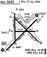
Runways
Runway Summary
| Runways: | 03/21 12/30 17/35 |
| Longest Runway: | 03/21 is 7398 ft (2255 m) long |
| Runways with an Instrument Approach: | 03 |
HOB Airport Runway Details
| Runway 03/21 | 7398 ft x 150 ft (2255 m x 46 m) | |
| Runway Length Source: | 3RD PARTY SURVEY as of 05/01/2010 | |
| Surface: | Asphalt - Good condition - Porous friction course | |
| Runway Pavement Class: | 44 /F/C/Y/T | |
| Runway Edge Lights: | High Intensity | |
Runway Weight Bearing Capacity (in thousands of pounds) |
||
| Single Wheel Landing Gear: | 112.0 | |
| Dual Wheel Landing Gear: | 168.0 | |
| Dual Tandem Wheel Landing Gear: | 259.0 | |
Runway 03 |
Runway 21 |
|
Elevation: |
3652.1 | 3646.2 |
Latitude: |
32-40-43.2834N | 32-41-34.9305N |
Longitude: |
103-13-33.1388W | 103-12-31.8282W |
|
Runway True Alignment: |
045 | 225 |
ILS Type: |
ILS/DME | |
Glide Path Angle: |
0.0 degrees | 3.0 degrees |
Traffic Pattern: |
Left | Left |
Runway Markings Type: |
Precision Instrument | Nonprecision Instrument |
Runway Markings Condition: |
Good | Good |
Visual Glide Slope Indicators: |
4-Light PAPI On Left Side Of Runway | |
Approach Light System: |
1,400 Foot Medium Intensity Approach Lighting System With Runway Alignment Indicator Lights | |
REIL: |
No | |
Threshold Crossing Height: |
44 | |
Declared Distances |
||
Take Off Run Avbl. (TORA): |
7398 | 7398 |
Take Off Distance Avbl. (TODA): |
7398 | 7398 |
Actual Stop Dist. Avbl. (ASDA): |
7020 | 7398 |
Landing Dist. Avbl. (LDA): |
7020 | 7398 |
| Runway 12/30 | 6002 ft x 150 ft (1829 m x 46 m) | |
| Runway Length Source: | 3RD PARTY SURVEY as of 05/01/2010 | |
| Surface: | Asphalt - Good condition - No special surface treatment | |
| Runway Pavement Class: | 48 /F/C/Y/T | |
| Runway Edge Lights: | Medium Intensity | |
Runway Weight Bearing Capacity (in thousands of pounds) |
||
| Single Wheel Landing Gear: | 120.0 | |
| Dual Wheel Landing Gear: | 171.0 | |
| Dual Tandem Wheel Landing Gear: | 279.0 | |
Runway 12 |
Runway 30 |
|
Elevation: |
3660.5 | 3637.6 |
Latitude: |
32-41-38.0851N | 32-40-56.0274N |
Longitude: |
103-13-16.6965W | 103-12-27.1397W |
|
Runway True Alignment: |
135 | 315 |
Glide Path Angle: |
3.0 degrees | 3.0 degrees |
Traffic Pattern: |
Left | Left |
Runway Markings Type: |
Nonprecision Instrument | Nonprecision Instrument |
Runway Markings Condition: |
Good | Good |
Visual Glide Slope Indicators: |
4-Light PAPI On Left Side Of Runway | 4-Light PAPI On Right Side Of Runway |
Threshold Crossing Height: |
49 | 44 |
Declared Distances |
||
Take Off Run Avbl. (TORA): |
6002 | 6002 |
Take Off Distance Avbl. (TODA): |
6002 | 6002 |
Actual Stop Dist. Avbl. (ASDA): |
6002 | 6002 |
Landing Dist. Avbl. (LDA): |
6002 | 6002 |
| Runway 17/35 | 4998 ft x 100 ft (1523 m x 30 m) | |
| Runway Length Source: | 3RD PARTY SURVEY as of 05/01/2010 | |
| Surface: | Asphalt - Good condition - No special surface treatment | |
| Runway Pavement Class: | 3 /F/B/Y/T | |
Runway Weight Bearing Capacity (in thousands of pounds) |
||
| Single Wheel Landing Gear: | 32.0 | |
| Dual Wheel Landing Gear: | 50.0 | |
Runway 17 |
Runway 35 |
|
Elevation: |
3659.7 | 3650.0 |
Latitude: |
32-41-46.1420N | 32-40-56.6959N |
Longitude: |
103-13-14.9805W | 103-13-15.0896W |
|
Runway True Alignment: |
180 | 000 |
Glide Path Angle: |
0.0 degrees | 0.0 degrees |
Traffic Pattern: |
Left | Left |
Runway Markings Type: |
Precision Instrument | Nonprecision Instrument |
Runway Markings Condition: |
Good | Good |
Threshold Elevation: |
3660.6 | |
Displaced Threshold: |
492 | |
Threshold Latitude: |
32-41-41.2743N | |
Threshold Longitude: |
103-13-14.9929W | |
Declared Distances |
||
Take Off Run Avbl. (TORA): |
4998 | 4998 |
Take Off Distance Avbl. (TODA): |
4998 | 4998 |
Actual Stop Dist. Avbl. (ASDA): |
4998 | 4998 |
Landing Dist. Avbl. (LDA): |
4506 | 4998 |
Services
Airframe Repair: |
Minor |
Powerplant Repair: |
Minor |
Fuel Available: |
100LL, Jet A |
Landing Fees: |
No |
Parking: |
Hangars and tiedowns available |
Maps & Diagrams
HOB Sectional
Flight Planning
at skyvector.com
at skyvector.com