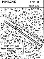
Location
Latitude: |
60-01-12.8430N (60.020234) |
Longitude: |
151-35-21.9070W (-151.589419) |
Elevation: |
276.0 feet MSL (84 m MSL) |
Magnetic Variation: |
14.1 E (as of April 2024 from WMM2020 model) |
Time Zone: |
UTC -9.0 (Standard Time) UTC -8.0 (Daylight Savings Time) |
From City: |
03 N.M. SE of Ninilchik, Alaska |
Found On: |
Mc Grath Chart |
FAA Region: |
AAL |
Contacts
Manager: |
Publicly owned: |
| ROB SMITH/SEAN PRESLEY STATE OF AK, PO BOX 1327 SOLDOTNA, AK 99669 907-262-1187 |
ALASKA DOT&PF CENTRAL REGION PO BOX 196900 ANCHORAGE, AK 99519-6900 (907) 269-0760 |
Operations
Airport Status: |
Operational |
Facility Use: |
Public |
Type: |
Airport |
Activation Date: |
10/1962 |
Control tower: |
No |
Attendance (Months/Days/Hours): |
Months/Days/Hours Unattended |
Boundary ARTCC: |
ZAN (Anchorage) |
Responsible ARTCC: |
ZAN (Anchorage) |
Segmented Circle Indicator: |
No |
Traffic Pattern Altitude (MSL): |
1276 feet (389 m) |
NOTAMs Facility: |
HOM |
NOTAM-D Service: |
Yes |
International Airport of Entry: |
No |
Customs Landing Rights: |
No |
Military Landing Rights: |
Yes |
Civil/Military Joint Use: |
No |
Based Aircraft
| Single Engine: | 8 |
| Ultralights: | 1 |
Annual Operations (as of 12/31/2019)
| Total Operations: | 1150 | |
| Air Taxi: | 150 | 13.0% |
| GA Itinerant: | 1000 | 87.0% |
Communications
| CTAF: | 122.900 |
Fixed Based Operators (FBOs) & Fuel
(Click on a business for detail)
Please help us keep this information up to date. This is a FREE SERVICE just like everything else on Airport Guide! If you see that a business needs to be added, modified, or deleted please fill out our Update Form.
To add, modify, or delete a business click here.
Please help us keep this information up to date. This is a FREE SERVICE just like everything else on Airport Guide! If you see that a business needs to be added, modified, or deleted please fill out our Update Form.
Area Code: 907 |
| Business Name | Frequency | Phone | Fuel Grade |
|---|
Flight Service Stations
| Primary | Alternate | |
| FSS on Field: | N | |
| FSS Name (ID): | Homer(HOM) | Kenai (ENA) |
| Frequency: | ||
| Toll Free Phone: | LC235-8588 | 1-866-864-1737 |
Instrument Procedures / Charts
Terminal Procedures are only available for airports in several countries with more being added all the time. If you are looking for a specific country's charts, please send an email to support(at)airportguide.com stating the country name. This will be used to prioritize the implementation.
Navigation Aids (Navaids) near NIN
| Dist (NM) | ID | Morse Code | Name | Type | Freq | True Hdg | Mag Hdg |
|---|---|---|---|---|---|---|---|
| 19.1 | HOM | . . . . _ _ _ _ _ | Homer | VOR-DME | 114.60 | 167 | 153 |
| 22.9 | ACE | . _ _ . _ . . | Kachemak | NDB | 277 | 173 | 159 |
| 34.5 | OLT | _ _ _ . _ . . _ | Soldotna | NDB-DME | 346 | 37 | 23 |
| 36.5 | IWW | . . . _ _ . _ _ | Wildwood | NDB | 379 | 17 | 3 |
| 37.5 | ENA | . _ . . _ | Kenai | VOR-DME | 117.60 | 18 | 4 |
| 82.6 | CMQ | _ . _ . _ _ _ _ . _ | Campbell Lake | NDB | 338 | 32 | 18 |
| 83.3 | ANC | . _ _ . _ . _ . | Anchorage | VOT | 108.40 | 33 | 19 |
| 83.9 | TED | _ . _ . . | Anchorage | VOR-DME | 113.15 | 34 | 20 |
| 88.3 | MRI | _ _ . _ . . . | Anchorage | VOT | 111.00 | 34 | 20 |
| 91.4 | EDF | . _ . . . . _ . | Elmendorf | TACAN | 113.40 | 35 | 21 |
Nearby Airports with Fuel
| Dist (NM) | Name (Airport IDs) | True Hdg | Mag Hdg | Fuel Grade |
|---|---|---|---|---|
| 22.7 | Homer Airport (HOM PAHO HOM) |
172 | 158 | 100LL, Jet A |
| 22.8 | Homer-Beluga Lake Seaplane Base (5BL) |
174 | 160 | 100LL |
| 31.8 | Soldotna Airport (SXQ PASX SXQ) |
30 | 16 | 100LL, Jet A |
| 34.7 | Kenai Municipal Airport (ENA PAEN ENA) |
17 | 3 | 100LL, Jet A |
| 83.6 | Ted Stevens Anchorage International Airport (ANC PANC ANC) |
33 | 18 | 100, 100LL, Jet A, Jet A-1 |
| 88.1 | Merrill Field Airport (MRI PAMR MRI) |
34 | 19 | 100, Jet A |
| 88.4 | Alaska Regional Hospital Heliport (2OK) |
35 | 20 | 100LL, Jet A |
Notices to Airmen (NOTAMS)
Remarks
| A110-2 | RY COND NOT MONITORED. RECOMMEND VISUAL INSPECTION PRIOR TO USE. |
| A110-3 | SAFETY AREAS AT BOTH RY ENDS SOFT. |
| A110-6 | STATE MAINTAINED ON IRREGULAR BASIS. |
| A110-8 | ULTRALIGHT ACTIVITY INVOF ARPT. |
| A42-10 | RWY EDGES NOT MARKED. |
Runways
Runway Summary
| Runways: | 10/28 |
| Longest Runway: | 10/28 is 2400 ft (732 m) long |
| Runways with an Instrument Approach: |
NIN Heliport Runway Details
| Runway 10/28 | 2400 ft x 60 ft (732 m x 18 m) | |
| Surface: | Gravel - Good condition - No special surface treatment | |
Runway 10 |
Runway 28 |
|
Glide Path Angle: |
0.0 degrees | 0.0 degrees |
Traffic Pattern: |
Left | Left |
Object at End: |
ROAD | TREES |
Object Height: |
15 | 50 |
Distance from End: |
0 | 0 |
Object Centerline Offset: |
80 ft. left and right of centerline | 125 ft. right of centerline |
Services
Fuel Available: |
100LL, Jet A |
Maps & Diagrams
NIN Sectional
Flight Planning
at skyvector.com
at skyvector.com