Location
Latitude: |
35-22-04.2200N (35.367839) |
Longitude: |
104-10-49.8300W (-104.180508) |
Elevation: |
4232.3 feet MSL (1290 m MSL) |
Magnetic Variation: |
6.8 E (as of April 2024 from WMM2020 model) |
Time Zone: |
UTC -7.0 (Standard Time) UTC -6.0 (Daylight Savings Time) |
From City: |
01 N.M. SW of Conchas Dam, New Mexico |
Found On: |
Albuquerque Chart |
FAA Region: |
ASW |
Contacts
Manager: |
Publicly owned: |
| JANE LUCERO 3501 ACCESS RD C, PO BOX 9830 ALBUQUERQUE, NM 87106 505-365-3891 |
NM DOT - AVIATION DIVISION PO BOX 9830 ALBUQUERQUE, NM 87119 505-417-8368 |
Operations
Airport Status: |
Operational |
Facility Use: |
Public |
Type: |
Airport |
Control tower: |
No |
Attendance (Months/Days/Hours): |
Months/Days/Hours Unattended |
Boundary ARTCC: |
ZAB (Albuquerque) |
Responsible ARTCC: |
ZAB (Albuquerque) |
Lighting Schedule: |
SEE RMK |
Segmented Circle Indicator: |
Yes |
Traffic Pattern Altitude (MSL): |
5232 feet (1595 m) |
NOTAMs Facility: |
ABQ |
NOTAM-D Service: |
Yes |
International Airport of Entry: |
No |
Customs Landing Rights: |
No |
Military Landing Rights: |
Yes |
Civil/Military Joint Use: |
No |
Based Aircraft
| Single Engine: | 1 |
Annual Operations (as of 03/31/2021)
| Total Operations: | 1000 | |
| GA Itinerant: | 1000 | 100.0% |
Communications
| CTAF: | 122.900 |
Fixed Based Operators (FBOs) & Fuel
(Click on a business for detail)
Please help us keep this information up to date. This is a FREE SERVICE just like everything else on Airport Guide! If you see that a business needs to be added, modified, or deleted please fill out our Update Form.
To add, modify, or delete a business click here.
Please help us keep this information up to date. This is a FREE SERVICE just like everything else on Airport Guide! If you see that a business needs to be added, modified, or deleted please fill out our Update Form.
Area Code: 505 |
| Business Name | Frequency | Phone | Fuel Grade |
|---|
Flight Service Stations
| Primary | Alternate | |
| FSS on Field: | N | |
| FSS Name (ID): | Albuquerque(ABQ) | |
| Frequency: | ||
| Toll Free Phone: | 1-800-WX-BRIEF |
Instrument Procedures / Charts
Terminal Procedures are only available for airports in several countries with more being added all the time. If you are looking for a specific country's charts, please send an email to support(at)airportguide.com stating the country name. This will be used to prioritize the implementation.
Navigation Aids (Navaids) near E89
| Dist (NM) | ID | Morse Code | Name | Type | Freq | True Hdg | Mag Hdg |
|---|---|---|---|---|---|---|---|
| 30.6 | TCC | _ _ . _ . _ . _ . | Tucumcari | VORTAC | 113.60 | 111 | 104 |
| 44.8 | ACH | . _ _ . _ . . . . . | Anton Chico | VORTAC | 117.80 | 250 | 243 |
| 49.8 | FTI | . . _ . _ . . | Fort Union | VORTAC | 117.30 | 290 | 283 |
| 72.8 | CVS | _ . _ . . . . _ . . . | Cannon | TACAN | 111.60 | 144 | 137 |
| 75.3 | CIM | _ . _ . . . _ _ | Cimarron | VORTAC | 116.40 | 333 | 326 |
| 78.6 | CV | _ . _ . . . . _ | Hisan | NDB | 335 | 140 | 133 |
| 81.7 | CAO | _ . _ . . _ _ _ _ | Clayton | NDB | 332 | 37 | 30 |
| 84.2 | TXO | _ _ . . _ _ _ _ | Texico | VORTAC | 112.20 | 128 | 122 |
| 87.9 | OTO | _ _ _ _ _ _ _ | Otto | VOR | 114.00 | 258 | 251 |
| 90.7 | DHT | _ . . . . . . _ | Dalhart | VORTAC | 112.00 | 60 | 54 |
| 92.7 | SAF | . . . . _ . . _ . | Santa Fe | VORTAC | 110.60 | 276 | 269 |
| 95.1 | CNX | _ . _ . _ . _ . . _ | Corona | VORTAC | 115.50 | 231 | 224 |
| 96.1 | HRX | . . . . . _ . _ . . _ | Hereford | NDB | 341 | 108 | 102 |
| 96.4 | SG | . . . _ _ . | Doman | NDB | 341 | 277 | 270 |
Nearby Airports with Fuel
Notices to Airmen (NOTAMS)
Remarks
| A110-1 | TWYS HAVE RETRO REFLECTIVE MARKERS. |
| A110-2 | WILDLIFE ON & INVOF AIRPORT. |
| A110-3 | GATE LOCK COMBINATION IS SET TO FIELD ELEVATION (4230). |
| A110-4 | FOR CD CTC ALBUQUERQUE ARTCC AT 505-856-4861. |
| A110-5 | USC & GS SURVEY MARKER 275 FT FROM THLD OF RWY 27, 55 FT LEFT OF CNTRL. |
| A40-09/27 | RY 09/27 RETRO REFLECTIVE MARKERS. |
| A49-09 | NSTD ODALS - 3 NSTD LGTS ON EXTDD RY CNTRLN ON LESS THAN STANDARD SPACING. |
| A49-27 | NSTD ODALS - 1 FLASHING LGT ON RY CNTRLN AND 2 FLASHING LGTS AT RY EDGES. |
| A58-09 | +5 FT USC&GS SURVEY MARKER 75' FROM END OF RWY, 52' LEFT OF CENTERLINE. |
| A81-APT | ACTVT ODALS RYS 09 & 27 - CTAF. |
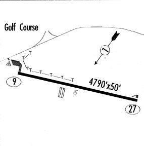
Runways
Runway Summary
| Runways: | 09/27 |
| Longest Runway: | 09/27 is 4800 ft (1463 m) long |
| Runways with an Instrument Approach: |
E89 Airport Runway Details
| Runway 09/27 | 4800 ft x 60 ft (1463 m x 18 m) | |
| Runway Length Source: | ADO as of 12/01/2011 | |
| Surface: | Asphalt - Good condition - No special surface treatment | |
| Runway Pavement Class: | 5 /F/D/Y/T | |
| Runway Edge Lights: | Non-standard lighting system Intensity | |
Runway Weight Bearing Capacity (in thousands of pounds) |
||
| Single Wheel Landing Gear: | 13.0 | |
Runway 09 |
Runway 27 |
|
Elevation: |
4232.3 | 4187.4 |
Latitude: |
35-22-09.1500N | 35-21-59.2900N |
Longitude: |
104-11-18.1700W | 104-10-21.4900W |
Glide Path Angle: |
0.0 degrees | 0.0 degrees |
Traffic Pattern: |
Left | Left |
Runway Markings Type: |
Basic | Basic |
Runway Markings Condition: |
Good | Good |
Approach Light System: |
Nonstandard | Nonstandard |
Services
Airframe Repair: |
Major |
Powerplant Repair: |
Major |
Fuel Available: |
100LL |
Landing Fees: |
No |
Parking: |
Tiedowns available |
Maps & Diagrams
E89 Sectional
Flight Planning
at skyvector.com
at skyvector.com