Location
Latitude: |
58-42-07.5000N (58.702083) |
Longitude: |
157-00-09.3000W (-157.002583) |
Elevation: |
162.3 feet MSL (49 m MSL) |
Magnetic Variation: |
11.9 E (as of April 2024 from WMM2020 model) |
Time Zone: |
UTC -9.0 (Standard Time) UTC -8.0 (Daylight Savings Time) |
From City: |
01 N.M. SSW of South Naknek, Alaska |
Found On: |
Kodiak Chart |
FAA Region: |
AAL |
Contacts
Manager: |
Publicly owned: |
| FLOYD WILSON PO BOX 65 KING SALMON, AK 99613 907-246-3325 |
ALASKA DOT&PF SOUTHCOAST REGION PO BOX 112500 JUNEAU, AK 99811-2500 907-465-4512 |
Operations
Airport Status: |
Operational |
Facility Use: |
Public |
Type: |
Airport |
Control tower: |
No |
Attendance (Months/Days/Hours): |
Months/Days/Hours Unattended |
Boundary ARTCC: |
ZAN (Anchorage) |
Responsible ARTCC: |
ZAN (Anchorage) |
Lighting Schedule: |
SEE RMK |
Segmented Circle Indicator: |
Yes |
Traffic Pattern Altitude (MSL): |
1162 feet (354 m) |
NOTAMs Facility: |
WSN |
NOTAM-D Service: |
Yes |
International Airport of Entry: |
No |
Customs Landing Rights: |
No |
Military Landing Rights: |
Yes |
Civil/Military Joint Use: |
No |
Based Aircraft
| Single Engine: | 1 |
| GA Helicopters: | 1 |
Annual Operations (as of 12/31/2022)
| Total Operations: | 3530 | |
| Air Taxi: | 3330 | 94.3% |
| GA Itinerant: | 200 | 5.7% |
Communications
| CTAF: | 122.900 |
| AWOS-3P: | 121.575 (907-868-7348) |
- APCH CTL PRVDD BY ANCHORAGE ARTCC (ZAN) ON 124.8/354.0 (KING SALMON RCAG).
Fixed Based Operators (FBOs) & Fuel
(Click on a business for detail)
Please help us keep this information up to date. This is a FREE SERVICE just like everything else on Airport Guide! If you see that a business needs to be added, modified, or deleted please fill out our Update Form.
To add, modify, or delete a business click here.
Please help us keep this information up to date. This is a FREE SERVICE just like everything else on Airport Guide! If you see that a business needs to be added, modified, or deleted please fill out our Update Form.
Area Code: 907 |
| Business Name | Frequency | Phone | Fuel Grade |
|---|
Flight Service Stations
| Primary | Alternate | |
| FSS on Field: | N | |
| FSS Name (ID): | Kenai(ENA) | |
| Frequency: | ||
| Toll Free Phone: | 1-866-864-1737 |
Instrument Procedures / Charts
FAA Terminal Procedures valid from 0901Z 03/21/24 to 0901Z 04/18/24.
There are various types of charts available for an airport. They are listed in the Page Type column. Here is a legend for those types:
APD - Airport Diagram
DP - Departure Procedure Charts
HOT - Hot Spots
IAP - Instrument Approach Procedure Charts
MIN - Minimums
STAR - Standard Terminal Arrival Charts
| Page Type | Page Name | Volume | Action Since Last Cycle |
|---|---|---|---|
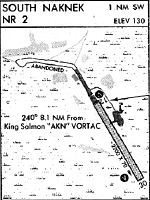
| IAP | RNAV (GPS) RWY 13 | AK-1 | |
| IAP | RNAV (GPS) RWY 31 | AK-1 | |
| MIN | ALTERNATE MINIMUMS | AK-1 | |
| MIN | TAKEOFF MINIMUMS | AK-1 |
Terminal Procedures are only available for airports in several countries with more being added all the time. If you are looking for a specific country's charts, please send an email to support(at)airportguide.com stating the country name. This will be used to prioritize the implementation.
Navigation Aids (Navaids) near WSN
| Dist (NM) | ID | Morse Code | Name | Type | Freq | True Hdg | Mag Hdg |
|---|---|---|---|---|---|---|---|
| 7.3 | AUB | . _ . . _ _ . . . | Chinook | NDB | 355 | 73 | 61 |
| 7.9 | AKN | . _ _ . _ _ . | King Salmon | VORTAC | 112.80 | 80 | 68 |
| 47.4 | HCP | . . . . _ . _ . . _ _ . | Kulik Lake | NDB | 334 | 65 | 53 |
| 51.2 | BTS | _ . . . _ . . . | Wood River | NDB | 429 | 291 | 279 |
| 51.2 | DLG | _ . . . _ . . _ _ . | Dillingham | VOR-DME | 116.40 | 290 | 278 |
| 89.8 | ILI | . . . _ . . . . | Iliamna | NDB-DME | 411 | 44 | 32 |
Nearby Airports with Fuel
| Dist (NM) | Name (Airport IDs) | True Hdg | Mag Hdg | Fuel Grade |
|---|---|---|---|---|
| 11.1 | King Salmon Airport (AKN PAKN AKN) |
97 | 85 | 100LL, Jet A |
| 50.9 | Dillingham Airport (DLG PADL DLG) |
294 | 283 | 100LL, Jet A |
| 60.7 | Aleknagik Seaplane Base (Z33) |
305 | 294 | 100LL, MOGAS |
| 60.9 | Aleknagik /New Airport (WKK 5A8) |
305 | 294 | 100LL, Jet A, Mogas |
| 89.9 | Iliamna Airport (ILI PAIL ILI) |
44 | 31 | 100LL, Jet A |
Notices to Airmen (NOTAMS)
Remarks
| A110*G | THIS AIRPORT HAS BEEN SURVEYED BY THE NATIONAL GEODETIC SURVEY. |
| A110-1 | RY COND NOT MONITORED; RECOMMEND VISUAL INSPECTION PRIOR TO USING. |
| A110-2 | TWY SLOPES DOWNHILL TO THE NW. NO LINE OF SIGHT BETWEEN END OF TWY & RY 13/31. |
| A110-3 | WX CAMERA AVBL ON INTERNET AT HTTPS://WEATHERCAMS.FAA.GOV |
| A110-4 | BE ALERT: VEHICLES, MOOSE, AND BEARS INVOF AND ON RYS. |
| A110-5 | HEAVY AIRCRAFT TRAFFIC BETWEEN SOUTH NAKNEK AND NAKNEK AIRPORTS LESS THAN TWO MILES APART. |
| A42-31 | RELOCATED RY 31 THRESHOLD MARKED BY SHORT CONES AND LIGHTS. |
| A81-APT | ACTVT VASI RWY 13; HIRL RWY 05/23 & 13/31 - CTAF. |
Runways
Runway Summary
| Runways: | 05/23 13/31 |
| Longest Runway: | 13/31 is 3314 ft (1010 m) long |
| Runways with an Instrument Approach: |
WSN Airport Runway Details
| Runway 05/23 | 2264 ft x 60 ft (690 m x 18 m) | |
| Runway Length Source: | NGS as of 06/16/2007 | |
| Surface: | Gravel/Dirt - Fair condition - No special surface treatment | |
| Runway Edge Lights: | High Intensity | |
Runway 05 |
Runway 23 |
|
Elevation: |
162.3 | 128.0 |
Latitude: |
58-42-09.4951N | 58-42-20.3208N |
Longitude: |
157-00-30.9178W | 156-59-53.4661W |
|
Runway True Alignment: |
061 | 241 |
Glide Path Angle: |
0.0 degrees | 0.0 degrees |
Object at End: |
BRUSH | BRUSH |
Object Height: |
20 | 7 |
Distance from End: |
0 | 0 |
Object Centerline Offset: |
115 ft. left of centerline | 71 ft. left of centerline |
| Runway 13/31 | 3314 ft x 60 ft (1010 m x 18 m) | |
| Runway Length Source: | NGS as of 06/16/2007 | |
| Surface: | Gravel/Dirt - Fair condition - No special surface treatment | |
| Runway Edge Lights: | High Intensity | |
Runway 13 |
Runway 31 |
|
Elevation: |
156.5 | 155.6 |
Latitude: |
58-42-14.7374N | 58-41-50.1103N |
Longitude: |
157-00-27.9535W | 156-59-46.7760W |
|
Runway True Alignment: |
139 | 319 |
Glide Path Angle: |
3.0 degrees | 0.0 degrees |
Traffic Pattern: |
Left | Left |
Runway Markings Type: |
Basic | Nonstandard (other than numbers only) |
Runway Markings Condition: |
Fair | Fair |
Object at End: |
BRUSH | BRUSH |
Object Height: |
9 | 6 |
Distance from End: |
4 | 0 |
Object Centerline Offset: |
115 ft. left of centerline | 71 ft. left of centerline |
Visual Glide Slope Indicators: |
2-Box VASI On Left Side Of Runway | |
Threshold Crossing Height: |
25 | |
Threshold Elevation: |
159.5 | |
Displaced Threshold: |
559 | |
Threshold Latitude: |
58-41-54.2651N | |
Threshold Longitude: |
156-59-53.7214W |
Services
Fuel Available: |
100LL, Jet A |
Parking: |
Tiedowns available |
Maps & Diagrams
WSN Sectional
Flight Planning
at skyvector.com
at skyvector.com