Location
Latitude: |
39-48-10.0440N (39.80279) |
Longitude: |
098-13-16.1830W (-98.221162) |
Elevation: |
1859.0 feet MSL (567 m MSL) |
Magnetic Variation: |
3.7 E (as of May 2024 from WMM2020 model) |
Time Zone: |
UTC -6.0 (Standard Time) UTC -5.0 (Daylight Savings Time) |
From City: |
01 N.M. NW of Mankato, Kansas |
Found On: |
Wichita Chart |
FAA Region: |
ACE |
Contacts
Manager: |
Publicly owned: |
| PHIL WALTON BOX 323 MANKATO, KS 66956 785-378-3942 |
CITY OF MANKATO 202 E. JEFFERSON MANKATO, KS 66956 785-378-3141 |
Operations
Airport Status: |
Operational |
Facility Use: |
Public |
Type: |
Airport |
Activation Date: |
12/1946 |
Control tower: |
No |
Attendance (Months/Days/Hours): |
Months/Days/Hours MAR-OCT/MON-FRI/0700-1700 |
Boundary ARTCC: |
ZMP (Minneapolis) |
Responsible ARTCC: |
ZMP (Minneapolis) |
Lighting Schedule: |
SS-SR |
Segmented Circle Indicator: |
No |
Traffic Pattern Altitude (MSL): |
2859 feet (871 m) |
NOTAMs Facility: |
ICT |
NOTAM-D Service: |
Yes |
Based Aircraft
| Single Engine: | 3 |
Annual Operations (as of 09/20/2018)
| Total Operations: | 5400 | |
| GA Local: | 2400 | 44.4% |
| GA Itinerant: | 3000 | 55.6% |
Communications
| CTAF: | 122.900 |
Fixed Based Operators (FBOs) & Fuel
(Click on a business for detail)
Please help us keep this information up to date. This is a FREE SERVICE just like everything else on Airport Guide! If you see that a business needs to be added, modified, or deleted please fill out our Update Form.
To add, modify, or delete a business click here.
Please help us keep this information up to date. This is a FREE SERVICE just like everything else on Airport Guide! If you see that a business needs to be added, modified, or deleted please fill out our Update Form.
Area Code: 785 |
| Business Name | Frequency | Phone | Fuel Grade |
|---|
Flight Service Stations
| Primary | Alternate | |
| FSS on Field: | N | |
| FSS Name (ID): | Wichita(ICT) | |
| Frequency: | ||
| Toll Free Phone: | 1-800-WX-BRIEF |
Instrument Procedures / Charts
Terminal Procedures are only available for airports in several countries with more being added all the time. If you are looking for a specific country's charts, please send an email to support(at)airportguide.com stating the country name. This will be used to prioritize the implementation.
Navigation Aids (Navaids) near KTKO
| Dist (NM) | ID | Morse Code | Name | Type | Freq | True Hdg | Mag Hdg |
|---|---|---|---|---|---|---|---|
| 1.8 | TKO | _ _ . _ _ _ _ | Mankato | VORTAC | 109.80 | 276 | 272 |
| 26.0 | RPB | . _ . . _ _ . _ . . . | Republican | NDB | 414 | 88 | 85 |
| 30.3 | CNK | _ . _ . _ . _ . _ | Concordia | NDB | 335 | 119 | 116 |
| 35.8 | HJH | . . . . . _ _ _ . . . . | Hebron | NDB | 323 | 54 | 51 |
| 49.0 | HSI | . . . . . . . . . | Hastings | VOR-DME | 108.80 | 348 | 344 |
| 49.6 | PHG | . _ _ . . . . . _ _ . | Phillipsburg | NDB | 368 | 263 | 259 |
| 53.5 | FBY | . . _ . _ . . . _ . _ _ | Fairbury | NDB | 293 | 64 | 61 |
| 54.3 | PSS | . _ _ . . . . . . . | Prosser | NDB | 338 | 347 | 343 |
| 55.2 | CYW | _ . _ . _ . _ _ . _ _ | Clay Center | NDB | 362 | 116 | 113 |
| 55.9 | FMZ | . . _ . _ _ _ _ . . | Beklof | NDB | 392 | 32 | 29 |
| 59.6 | SLN | . . . . _ . . _ . | Salina | VORTAC | 117.10 | 151 | 148 |
| 61.6 | EA | . . _ | Anoke | NDB | 422 | 323 | 319 |
| 64.3 | GR | _ _ . . _ . | Sancy | NDB | 380 | 356 | 352 |
| 66.0 | EAR | . . _ . _ . | Kearney | VOR | 111.20 | 327 | 323 |
| 71.0 | GRI | _ _ . . _ . . . | Grand Island | VOR-DME | 112.00 | 356 | 352 |
| 71.3 | JYR | . _ _ _ _ . _ _ . _ . | York | NDB | 257 | 22 | 19 |
| 72.4 | SL | . . . . _ . . | Flory | NDB | 344 | 158 | 155 |
| 73.7 | BIE | _ . . . . . . | Beatrice | VOR | 110.60 | 65 | 62 |
| 75.4 | HYS | . . . . _ . _ _ . . . | Hays | VORTAC | 110.40 | 220 | 216 |
| 77.0 | NRN | _ . . _ . _ . | Norton | NDB | 230 | 272 | 268 |
Nearby Airports with Fuel
Notices to Airmen (NOTAMS)
Remarks
| A110-2 | LGTD/MKD TWR 2 MI NE OF ARPT 300' AGL; ALSO A MKD/LGTD 300+ AGL TWR APRX 1.5 MI SE OF ARPT. |
| A110-3 | TELEPHONE AVBL 24 HRS.(LCL CALLS ONLY} |
| A33-09/27 | AT THE INTERSECTION OF 09/27 & 17/35 A SLIGHT CHANGE IN ELEVATION MAY CAUSE A ROUGH CROSSING. |
| A42-09 | 09/27 APCH ENDS MARKED WITH WHITE PAINTED TIRES. |
| A53-17 | WHITE PAINTED TIRES DELINEATE THE 4 FT FENCE ON THE AER 17. |
| E111 | PRVDD RWY APCHS MAINT FOR MIN 20:1 GLIDE SLOPE & TRSNL SFC MAINT FOR 7:1 SLOPE. |
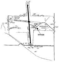
Runways
Runway Summary
| Runways: | 09/27 17/35 |
| Longest Runway: | 17/35 is 3540 ft (1079 m) long |
| Runways with an Instrument Approach: |
KTKO Airport Runway Details
| Runway 09/27 | 2505 ft x 100 ft (764 m x 30 m) | |
| Runway Length Source: | STATE as of 09/11/2003 | |
| Surface: | Turf - Good condition - No special surface treatment | |
Runway 09 |
Runway 27 |
|
Glide Path Angle: |
0.0 degrees | 0.0 degrees |
Traffic Pattern: |
Left | Left |
Runway Markings Type: |
Nonstandard (other than numbers only) | Nonstandard (other than numbers only) |
Object at End: |
TREES | ROAD |
Object Height: |
19 | 15 |
Distance from End: |
0 | 120 |
Object Centerline Offset: |
100 ft. right of centerline | 0 ft. left and right of centerline |
| Runway 17/35 | 3540 ft x 50 ft (1079 m x 15 m) | |
| Runway Length Source: | FAA as of 05/24/2002 | |
| Surface: | Turf - Good condition - No special surface treatment | |
| Runway Edge Lights: | Low Intensity | |
Runway 17 |
Runway 35 |
|
Glide Path Angle: |
0.0 degrees | 0.0 degrees |
Traffic Pattern: |
Left | Left |
Runway Markings Type: |
Nonprecision Instrument | Nonprecision Instrument |
Runway Markings Condition: |
Good | Good |
Object at End: |
FENCE | |
Object Height: |
4 | |
Object Marked/Lighted?: |
Marked | |
Distance from End: |
200 | |
Object Centerline Offset: |
100 ft. right of centerline | 0 ft. left and right of centerline |
Services
Airframe Repair: |
Minor |
Powerplant Repair: |
Minor |
Bottled Oxygen: |
None |
Bulk Oxygen: |
None |
Fuel Available: |
100LL, Jet A |
Landing Fees: |
No |
Parking: |
Hangars and tiedowns available |
Maps & Diagrams
KTKO Sectional
Flight Planning
at skyvector.com
at skyvector.com