Location
Latitude: |
40-18-04.6000N (40.301278) |
Longitude: |
096-45-14.8000W (-96.754111) |
Elevation: |
1323.6 feet MSL (403 m MSL) |
Magnetic Variation: |
2.7 E (as of April 2024 from WMM2020 model) |
Time Zone: |
UTC -6.0 (Standard Time) UTC -5.0 (Daylight Savings Time) |
From City: |
03 N.M. N of Beatrice, Nebraska |
Found On: |
Omaha Chart |
FAA Region: |
ACE |
Contacts
Manager: |
Publicly owned: |
| DENNIS SCHMITT P.O. BOX 277 BEATRICE, NE 68310-0277 402-223-5349 |
CITY OF BEATRICE BOX 277 BEATRICE, NE 68310-0277 402-223-5349 |
Operations
Airport Status: |
Operational |
Facility Use: |
Public |
Type: |
Airport |
Activation Date: |
03/1941 |
Control tower: |
No |
Attendance (Months/Days/Hours): |
Months/Days/Hours ALL/ALL/0700-1900 |
Boundary ARTCC: |
ZMP (Minneapolis) |
Responsible ARTCC: |
ZMP (Minneapolis) |
Lighting Schedule: |
SEE RMK |
Segmented Circle Indicator: |
Yes |
Traffic Pattern Altitude (MSL): |
2324 feet (708 m) |
NOTAMs Facility: |
BIE |
NOTAM-D Service: |
Yes |
International Airport of Entry: |
No |
Customs Landing Rights: |
No |
Military Landing Rights: |
Yes |
Civil/Military Joint Use: |
No |
Based Aircraft
| Single Engine: | 32 |
Annual Operations (as of 06/21/2023)
| Total Operations: | 11000 | |
| Air Taxi: | 700 | 6.4% |
| GA Local: | 5950 | 54.1% |
| GA Itinerant: | 4150 | 37.7% |
| Military Aircraft: | 200 | 1.8% |
Communications
| CTAF: | 122.800 |
| Unicom: | 122.800 |
| AWOS-3: | 125.325 (402-228-3229) |
- COMMUNICATIONS PRVDD BY COLUMBUS RADIO ON FREQ 122.5 (BEATRICE RCO).
- APCH/DEP SVC PRVDD BY MINNEAPOLIS ARTCC ON FREQS 126.4/317.7 (MARYSVILLE RCAG).
Fixed Based Operators (FBOs) & Fuel
(Click on a business for detail)
Please help us keep this information up to date. This is a FREE SERVICE just like everything else on Airport Guide! If you see that a business needs to be added, modified, or deleted please fill out our Update Form.
To add, modify, or delete a business click here.
Please help us keep this information up to date. This is a FREE SERVICE just like everything else on Airport Guide! If you see that a business needs to be added, modified, or deleted please fill out our Update Form.
Area Code: 402 |
| Business Name | Frequency | Phone | Fuel Grade |
|---|---|---|---|
| Beatrice Airport
Update FBO info |
Unicom 122.8 | 223-5349, 228-4585 | 100LL, Jet A |
| Koehler Aircraft Repair
Update FBO info |
223-3118, 223-3299 |
Flight Service Stations
| Primary | Alternate | |
| FSS on Field: | N | |
| FSS Name (ID): | Columbus(OLU) | |
| Frequency: | ||
| Toll Free Phone: | 1-800-WX-BRIEF |
Instrument Procedures / Charts
FAA Terminal Procedures valid from 0901Z 03/21/24 to 0901Z 04/18/24.
There are various types of charts available for an airport. They are listed in the Page Type column. Here is a legend for those types:
APD - Airport Diagram
DP - Departure Procedure Charts
HOT - Hot Spots
IAP - Instrument Approach Procedure Charts
MIN - Minimums
STAR - Standard Terminal Arrival Charts
| Page Type | Page Name | Volume | Action Since Last Cycle |
|---|---|---|---|
| IAP | RNAV (GPS) RWY 14 | NC-2 | |
| IAP | RNAV (GPS) RWY 18 | NC-2 | |
| IAP | RNAV (GPS) RWY 32 | NC-2 | |
| IAP | RNAV (GPS) RWY 36 | NC-2 | |
| IAP | VOR RWY 18 | NC-2 | |
| IAP | VOR RWY 36 | NC-2 | |
| MIN | ALTERNATE MINIMUMS | NC-2 | |
| MIN | TAKEOFF MINIMUMS | NC-2 |
Terminal Procedures are only available for airports in several countries with more being added all the time. If you are looking for a specific country's charts, please send an email to support(at)airportguide.com stating the country name. This will be used to prioritize the implementation.
Navigation Aids (Navaids) near BIE
| Dist (NM) | ID | Morse Code | Name | Type | Freq | True Hdg | Mag Hdg |
|---|---|---|---|---|---|---|---|
| 0.0 | BIE | _ . . . . . . | Beatrice | VOR | 110.60 | 288 | 285 |
| 20.3 | FBY | . . _ . _ . . . _ . _ _ | Fairbury | NDB | 293 | 248 | 245 |
| 25.8 | PWE | . _ _ . . _ _ . | Pawnee City | DME | 112.4 | 103 | 101 |
| 26.8 | LN | . _ . . _ . | Potts | NDB | 385 | 359 | 356 |
| 37.3 | SWT | . . . . _ _ _ | Seward | NDB | 269 | 334 | 331 |
| 37.4 | LNK | . _ . . _ . _ . _ | Lincoln | VORTAC | 116.10 | 0 | 357 |
| 39.2 | HJH | . . . . . _ _ _ . . . . | Hebron | NDB | 323 | 256 | 253 |
| 41.0 | FMZ | . . _ . _ _ _ _ . . | Beklof | NDB | 392 | 295 | 292 |
| 44.7 | AFK | . _ . . _ . _ . _ | Nebraska City | NDB | 347 | 65 | 63 |
| 50.8 | RPB | . _ . . _ _ . _ . . . | Republican | NDB | 414 | 235 | 232 |
| 53.2 | JYR | . _ _ _ _ . _ _ . _ . | York | NDB | 257 | 312 | 309 |
| 54.4 | PMV | . _ _ . _ _ . . . _ | Plattsmouth | NDB | 329 | 44 | 42 |
| 55.2 | FNB | . . _ . _ . _ . . . | Brenner | NDB | 404 | 103 | 101 |
| 56.7 | AHQ | . _ . . . . _ _ . _ | Wahoo | NDB | 400 | 7 | 4 |
| 58.3 | CYW | _ . _ . _ . _ _ . _ _ | Clay Center | NDB | 362 | 198 | 195 |
| 61.0 | CNK | _ . _ . _ . _ . _ | Concordia | NDB | 335 | 222 | 219 |
| 61.0 | MLE | _ _ . _ . . . | Millard | NDB | 371 | 28 | 26 |
| 62.5 | OFF | _ _ _ . . _ . . . _ . | Offutt | TACAN | 111.70 | 38 | 36 |
| 66.8 | RBA | . _ . _ . . . . _ | Robinson | DME | 108.2 | 113 | 111 |
| 67.1 | SDA | . . . _ . . . _ | Shenandoah | NDB | 411 | 65 | 63 |
Nearby Airports with Fuel
Notices to Airmen (NOTAMS)
Remarks
| A110-1 | RWY 18 IS DESIGNATED AS THE CALM WIND RWY. |
| A110-2 | 400' STOPWAY AT RWY 36 DER. |
| A110-3 | FOR CD IF UNA TO CTC ON FSS FREQ, CTC MINNEAPOLIS ARTCC AT 651-463-5588. |
| A17 | WINTER HOURS 0700-1800 |
| A17 1 | FOR SVC AFT HRS CALL 913-433-4671 OR 402-520-0856. |
| A70-FUEL-10 | 0LL FUEL AVBL H24 VIA CREDIT CARD. |
| A70-FUEL-A | JET A FUEL SVC AFT HRS CALL 913-433-4671 OR 402-520-0856. |
| A75 | CTC ARPT REG HNGR AVBLITY. |
| A81-APT | ACTVT MALSR RWY 36; REIL RWY 14 & 32 - CTAF. MIRL RWY 14/32 & RWY 18/36 OPR SS-SR. PAPI RWY 36 OPR CONSLY. |
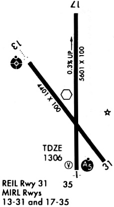
Runways
Runway Summary
| Runways: | 14/32 18/36 |
| Longest Runway: | 18/36 is 5602 ft (1707 m) long |
| Runways with an Instrument Approach: |
BIE Airport Runway Details
| Runway 14/32 | 4401 ft x 75 ft (1341 m x 23 m) | |
| Surface: | Concrete - Good condition - No special surface treatment | |
| Runway Edge Lights: | Medium Intensity | |
Runway Weight Bearing Capacity (in thousands of pounds) |
||
| Single Wheel Landing Gear: | 35.0 | |
| Dual Wheel Landing Gear: | 45.5 | |
Runway 14 |
Runway 32 |
|
Elevation: |
1319.2 | 1311.8 |
Latitude: |
40-18-18.1725N | 40-17-43.3501N |
Longitude: |
096-45-34.3007W | 096-45-00.2758W |
|
Runway True Alignment: |
143 | 323 |
Glide Path Angle: |
0.0 degrees | 0.0 degrees |
Traffic Pattern: |
Left | Left |
Runway Markings Type: |
Nonprecision Instrument | Nonprecision Instrument |
Runway Markings Condition: |
Good | Good |
REIL: |
Yes | Yes |
| Runway 18/36 | 5602 ft x 100 ft (1707 m x 30 m) | |
| Surface: | Concrete - Good condition - No special surface treatment | |
| Runway Edge Lights: | Medium Intensity | |
Runway Weight Bearing Capacity (in thousands of pounds) |
||
| Single Wheel Landing Gear: | 35.0 | |
| Dual Wheel Landing Gear: | 45.5 | |
Runway 18 |
Runway 36 |
|
Elevation: |
1323.6 | 1304.6 |
Latitude: |
40-18-35.3687N | 40-17-40.0156N |
Longitude: |
096-45-13.1095W | 096-45-12.6379W |
|
Runway True Alignment: |
180 | 360 |
Glide Path Angle: |
0.0 degrees | 3.0 degrees |
Traffic Pattern: |
Left | Left |
Runway Markings Type: |
Nonprecision Instrument | Nonprecision Instrument |
Runway Markings Condition: |
Good | Good |
Visual Glide Slope Indicators: |
2-Light PAPI On Left Side Of Runway | |
Approach Light System: |
1,400 Foot Medium Intensity Approach Lighting System With Runway Alignment Indicator Lights | |
Threshold Crossing Height: |
41 | |
Declared Distances |
||
Take Off Run Avbl. (TORA): |
5602 | 5602 |
Take Off Distance Avbl. (TODA): |
5602 | 5602 |
Actual Stop Dist. Avbl. (ASDA): |
5602 | 6002 |
Landing Dist. Avbl. (LDA): |
5602 | 5602 |
Services
Airframe Repair: |
None |
Powerplant Repair: |
None |
Bottled Oxygen: |
None |
Bulk Oxygen: |
None |
Fuel Available: |
100LL |
Landing Fees: |
No |
Parking: |
Tiedowns available |
Maps & Diagrams
BIE Sectional
Flight Planning
at skyvector.com
at skyvector.com