Location
Latitude: |
33-37-22.4000N (33.622889) |
Longitude: |
111-54-37.9000W (-111.910528) |
Elevation: |
1510.1 feet MSL (460 m MSL) |
Magnetic Variation: |
9.7 E (as of April 2024 from WMM2020 model) |
Time Zone: |
UTC -7.0 (Standard Time) UTC -7.0 (Daylight Savings Time) |
From City: |
09 N.M. N of Scottsdale, Arizona |
Found On: |
Phoenix Chart |
FAA Region: |
AWP |
Contacts
Manager: |
Publicly owned: |
| GARY MASCARO 15000 N AIRPORT DR, SUITE 100 SCOTTSDALE, AZ 85260 480-312-7735 |
CITY OF SCOTTSDALE 3939 CIVIC CENTER PLAZA SCOTTSDALE, AZ 85251 480-312-2321 |
Operations
Airport Status: |
Operational |
Facility Use: |
Public |
Type: |
Airport |
Activation Date: |
03/1943 |
Control tower: |
Yes |
Attendance (Months/Days/Hours): |
Months/Days/Hours ALL/ALL/ALL |
Boundary ARTCC: |
ZAB (Albuquerque) |
Responsible ARTCC: |
ZAB (Albuquerque) |
Lighting Schedule: |
SEE RMK |
Segmented Circle Indicator: |
Yes |
Traffic Pattern Altitude (MSL): |
2510 feet (765 m) |
NOTAMs Facility: |
SDL |
NOTAM-D Service: |
Yes |
International Airport of Entry: |
No |
Customs Landing Rights: |
No |
Military Landing Rights: |
Yes |
Civil/Military Joint Use: |
No |
Based Aircraft
| Single Engine: | 120 |
| Multi Engine: | 26 |
| Jet Engine: | 150 |
| GA Helicopters: | 44 |
Annual Operations (as of 12/31/2020)
| Total Operations: | 202564 | |
| Air Taxi: | 16610 | 8.2% |
| GA Local: | 65430 | 32.3% |
| GA Itinerant: | 119917 | 59.2% |
| Military Aircraft: | 607 | 0.3% |
Communications
| CTAF: | 119.900 |
| Tower: | SCOTTSDALE 119.9 Hrs: 0600-2100 |
| Clearance Del.: | 124.8 |
| Ground: | 121.6 |
| Approach: | PHOENIX 120.7 120.7 120.7 120.7 120.7 120.7 |
| Departure: | PHOENIX 120.7 120.7 120.7 120.7 120.7 120.7 |
| ATIS: | 118.6 Hrs: 0600-2100 |
| ASOS: | (480-483-3049) |
| HEL OPS: | 125.5 |
- EMERG FREQ 121.5 NOT AVBL AT ATCT.
- COMMUNICATIONS PRVDD BY PRESCOTT RADIO ON FREQ 122.2 (PHOENIX RCO).
- ASOS BROADCASTS ON ATIS FREQ 118.6 WHEN ATCT CLSD.
Fixed Based Operators (FBOs) & Fuel
(Click on a business for detail)
Please help us keep this information up to date. This is a FREE SERVICE just like everything else on Airport Guide! If you see that a business needs to be added, modified, or deleted please fill out our Update Form.
To add, modify, or delete a business click here.
Please help us keep this information up to date. This is a FREE SERVICE just like everything else on Airport Guide! If you see that a business needs to be added, modified, or deleted please fill out our Update Form.
Area Code: 480 |
| Business Name | Frequency | Phone | Fuel Grade |
|---|---|---|---|
| Corporate Jets, Inc. AVITAT
Update FBO info |
Unicom 122.95, Arinc 129.7 | 948-2400, 800-995-5387(JETS) | 100LL, Jet A |
| Dallas Airmotive
Website Update FBO info |
905-8788 | ||
| Executive Aircraft Services
Update FBO info |
Unicom 122.95 | 991-0900, 800-833-3385 | 100LL, Jet A |
| Professional Airline Systems (P.S.A.)
Update FBO info |
607-7674 | ||
| Scottsdale Aero Supply
Update FBO info |
948-8994, 800-473-5975 | ||
| Scottsdale Flyers
Update FBO info |
922-8681 | ||
| Signature Flight Support
Update FBO info |
Unicom: 122.95, Arinc: 131.175 | +1 480 951 2525 | |
| Southwest Flight Center
Update FBO info |
991-2880 | ||
| Westcor Aviation
Update FBO info |
991-6558 |
Flight Service Stations
| Primary | Alternate | |
| FSS on Field: | N | |
| FSS Name (ID): | Prescott(PRC) | |
| Frequency: | ||
| Toll Free Phone: | 1-800-WX-BRIEF |
Instrument Procedures / Charts
FAA Terminal Procedures valid from 0901Z 03/21/24 to 0901Z 04/18/24.
There are various types of charts available for an airport. They are listed in the Page Type column. Here is a legend for those types:
APD - Airport Diagram
DP - Departure Procedure Charts
HOT - Hot Spots
IAP - Instrument Approach Procedure Charts
MIN - Minimums
STAR - Standard Terminal Arrival Charts
| Page Type | Page Name | Volume | Action Since Last Cycle |
|---|---|---|---|
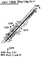
| APD | AIRPORT DIAGRAM | SW-4 | |
| DP | BNYRD SIX (RNAV) | SW-4 | |
| DP | FTHLS SIX (RNAV) | SW-4 | |
| DP | IZZZO EIGHT (RNAV) | SW-4 | |
| DP | JONHH TWO | SW-4 | |
| DP | JONHH TWO[DELIMITER] CONT.1 | SW-4 | |
| DP | JUDTH SEVEN (RNAV) | SW-4 | |
| DP | KATMN SIX (RNAV) | SW-4 | |
| DP | LALUZ SIX (RNAV) | SW-4 | |
| DP | MAYSA SEVEN (RNAV) | SW-4 | |
| DP | SCOTTSDALE SEVEN | SW-4 | |
| DP | SCOTTSDALE SEVEN[DELIMITER] CONT.1 | SW-4 | |
| DP | SNOBL SIX (RNAV) | SW-4 | |
| DP | YOTES SIX (RNAV) | SW-4 | |
| IAP | RNAV (GPS)-D | SW-4 | |
| IAP | RNAV (GPS)-E | SW-4 | |
| IAP | RNAV (RNP) RWY 21 | SW-4 | |
| IAP | RNAV (RNP) Y RWY 03 | SW-4 | |
| IAP | RNAV (RNP) Z RWY 03 | SW-4 | |
| IAP | VOR/DME-A | SW-4 | |
| MIN | ALTERNATE MINIMUMS | SW-4 | |
| MIN | DIVERSE VECTOR AREA | SW-4 | |
| MIN | TAKEOFF MINIMUMS | SW-4 | |
| ODP | MARICOPA ONE (OBSTACLE) | SW-4 | |
| STAR | ARLIN FOUR | SW-4 | |
| STAR | BLYTHE FIVE | SW-4 | |
| STAR | DSERT TWO (RNAV) | SW-4 | |
| STAR | DSERT TWO (RNAV)[DELIMITER] CONT.1 | SW-4 | |
| STAR | SUNSS EIGHT | SW-4 |
Terminal Procedures are only available for airports in several countries with more being added all the time. If you are looking for a specific country's charts, please send an email to support(at)airportguide.com stating the country name. This will be used to prioritize the implementation.
Navigation Aids (Navaids) near SCF
| Dist (NM) | ID | Morse Code | Name | Type | Freq | True Hdg | Mag Hdg |
|---|---|---|---|---|---|---|---|
| 11.8 | PXR | . _ _ . _ . . _ . _ . | Phoenix | VORTAC | 115.60 | 194 | 184 |
| 12.3 | PHX | . _ _ . . . . . _ . . _ | Phoenix | VOT | 109.00 | 203 | 193 |
| 13.1 | FFZ | . . _ . . . _ . _ _ . . | Falcon Field | NDB | 281 | 137 | 127 |
| 22.0 | CHD | _ . _ . . . . . _ . . | Chandler | NDB | 407 | 166 | 156 |
| 23.2 | IWA | . . . _ _ . _ | Willie | VORTAC | 113.30 | 145 | 135 |
| 24.0 | LUF | . _ . . . . _ . . _ . | Luke | TACAN | 113.00 | 257 | 247 |
| 44.2 | TFD | _ . . _ . _ . . | Stanfield | VORTAC | 114.80 | 179 | 169 |
| 46.8 | BXK | _ . . . _ . . _ _ . _ | Buckeye | VORTAC | 110.60 | 257 | 247 |
| 47.5 | PAN | . _ _ . . _ _ . | Payson | DME | 116.35 | 36 | 26 |
| 55.4 | GBN | _ _ . _ . . . _ . | Gila Bend | VORTAC | 116.60 | 223 | 213 |
| 66.7 | PRC | . _ _ . . _ . _ . _ . | Prescott | VOT | 110.00 | 337 | 327 |
| 70.7 | DRK | _ . . . _ . _ . _ | Drake | VORTAC | 114.10 | 336 | 326 |
| 80.6 | AVQ | . _ . . . _ _ _ . _ | Marana | NDB | 245 | 154 | 145 |
| 92.2 | FLG | . . _ . . _ . . _ _ . | Flagstaff | VOR-DME | 113.85 | 7 | 357 |
| 96.7 | RYN | . _ . _ . _ _ _ . | Ryan | NDB | 338 | 156 | 147 |
| 97.0 | RBJ | . _ . _ . . . . _ _ _ | Robles | NDB | 220 | 163 | 154 |
Nearby Airports with Fuel
Notices to Airmen (NOTAMS)
Remarks
| A110-17 | MIL ARR 24 HR PPR - 480-312-8478. |
| A110-18 | MIDFIELD DEP NA. |
| A110-19 | VOLUNTARY NOISE ABATEMENT CURFEW 2200-0600; NOISE SENSITIVE AREA ALL QUADS; NOISE ABATEMENT - 480-312-8478. |
| A110-2 | WILDLIFE INVOF RWY. |
| A110-21 | FOR CD WHEN ATCT CLSD, CTC PHOENIX APCH AT 602-306-2565. |
| A110-6 | TGL NA 2130-0600. |
| A110-8 | MAINT RUNUP NA 2200-0700. |
| A24 | TSNT FEE FOR ACFT 12500 LB OR GREATER BASED ON MAX CERT RAMP WEIGHT; TSNT OVERNIGHT PARKING FEE. |
| A30-03/21 | RWY 03 CALM WIND RWY. |
| A31-03/21 | 200 FT BLAST PAD BOTH ENDS. |
| A36-03/21 | CERT MAX TKOF WGT 75001 - 100000 LB OPRG ABV 75000 LB PPR - 480-312-8478. |
| A57-03 | APCH SLOPE 50:1 AT DTHR. |
| A57-21 | APCH SLOPE 39:1 AT DTHR. |
| A81-APT | WHEN ATCT CLSD ACTVT REIL RWY 03 & 21; PAPI RWY 03 & 21; MIRL RWY 03/21 - CTAF. |
| E147 | TPA PROP 990 FT; JET 1490 FT; HELICOPTER 490 FT AGL. |
| E80 | US CUSTOMS USER FEE ARPT. |
| E80A | CUSTOMS SVC AVBL 1600Z TO 0200Z; USER FEE MUST BE PREPAID ONLINE PRIOR TO ARR. |
Runways
Runway Summary
| Runways: | 03/21 |
| Longest Runway: | 03/21 is 8249 ft (2514 m) long |
| Runways with an Instrument Approach: |
SCF Airport Runway Details
| Runway 03/21 | 8249 ft x 100 ft (2514 m x 30 m) | |
| Runway Length Source: | 3RD PARTY SURVEY as of 08/12/2013 | |
| Surface: | Asphalt - Good condition - No special surface treatment | |
| Runway Edge Lights: | Medium Intensity | |
Runway Weight Bearing Capacity (in thousands of pounds) |
||
| Single Wheel Landing Gear: | 45.0 | |
| Dual Wheel Landing Gear: | 75.0 | |
Runway 03 |
Runway 21 |
|
Elevation: |
1444.2 | 1510.1 |
Latitude: |
33-36-53.0117N | 33-37-51.7182N |
Longitude: |
111-55-11.7848W | 111-54-04.0392W |
|
Runway True Alignment: |
044 | 224 |
Glide Path Angle: |
4.0 degrees | 4.0 degrees |
Traffic Pattern: |
Left | Right |
Runway Markings Type: |
Nonprecision Instrument | Nonprecision Instrument |
Runway Markings Condition: |
Good | Good |
Object at End: |
TREE | HILL |
Object Height: |
58 | 25 |
Distance from End: |
1695 | 850 |
Object Centerline Offset: |
390 ft. right of centerline | 375 ft. right of centerline |
Visual Glide Slope Indicators: |
2-Light PAPI On Left Side Of Runway | 2-Light PAPI On Left Side Of Runway |
REIL: |
Yes | Yes |
Touchdown Lights: |
No | No |
Centerline Lights: |
No | No |
Threshold Crossing Height: |
59 | 40 |
Threshold Elevation: |
1447.9 | 1507.2 |
Displaced Threshold: |
740 | 400 |
Threshold Latitude: |
33-36-58.2786N | 33-37-48.8714N |
Threshold Longitude: |
111-55-05.7080W | 111-54-07.3246W |
Declared Distances |
||
Take Off Run Avbl. (TORA): |
8249 | 8249 |
Take Off Distance Avbl. (TODA): |
8249 | 8249 |
Actual Stop Dist. Avbl. (ASDA): |
7849 | 8069 |
Landing Dist. Avbl. (LDA): |
7110 | 7669 |
Services
Airframe Repair: |
Minor |
Powerplant Repair: |
Minor |
Fuel Available: |
100LL, Jet A |
Landing Fees: |
Yes |
Parking: |
Hangars and tiedowns available |
Maps & Diagrams
SCF Sectional
Flight Planning
at skyvector.com
at skyvector.com