Location
Latitude: |
33-13-04.7150N (33.217976) |
Longitude: |
117-21-05.4270W (-117.351508) |
Elevation: |
28.0 feet MSL (9 m MSL) |
Magnetic Variation: |
11.1 E (as of April 2024 from WMM2020 model) |
Time Zone: |
UTC -8.0 (Standard Time) UTC -7.0 (Daylight Savings Time) |
From City: |
02 N.M. NE of Oceanside, California |
Found On: |
Los Angeles Chart |
FAA Region: |
AWP |
Contacts
Manager: |
Publicly owned: |
| ANDREW WIGNOT 480 AIRPORT ROAD, SUITE 715 OCEANSIDE, CA 92058 (760) 901-4260 |
CITY OF OCEANSIDE 300 NORTH COAST HIGHWAY OCEANSIDE, CA 92054 (760) 435-5012 |
Operations
Airport Status: |
Operational |
Facility Use: |
Public |
Type: |
Airport |
Activation Date: |
06/1963 |
Control tower: |
No |
Attendance (Months/Days/Hours): |
Months/Days/Hours ALL/ALL/0900-1700 |
Boundary ARTCC: |
ZLA (Los Angeles) |
Responsible ARTCC: |
ZLA (Los Angeles) |
Lighting Schedule: |
SEE RMK |
Segmented Circle Indicator: |
Yes |
Traffic Pattern Altitude (MSL): |
1028 feet (313 m) |
NOTAMs Facility: |
OKB |
NOTAM-D Service: |
Yes |
International Airport of Entry: |
No |
Customs Landing Rights: |
No |
Military Landing Rights: |
No |
Civil/Military Joint Use: |
No |
Based Aircraft
| Single Engine: | 62 |
| Multi Engine: | 2 |
| GA Helicopters: | 4 |
| Gliders: | 1 |
Annual Operations (as of 12/31/2023)
| Total Operations: | 26099 | |
| GA Local: | 12033 | 46.1% |
| GA Itinerant: | 14066 | 53.9% |
Communications
| CTAF: | 122.725 |
| Unicom: | 122.725 |
| Approach: | SOCAL 127.3 127.3 127.3 127.3 |
| Departure: | SOCAL 127.3 127.3 127.3 127.3 |
| ASOS: | 127.8 (760-439-9683) |
- COMMUNICATIONS PRVDD BY SAN DIEGO RADIO ON FREQS 122.1R/115.3T (OCEANSIDE RCO).
Fixed Based Operators (FBOs) & Fuel
(Click on a business for detail)
Please help us keep this information up to date. This is a FREE SERVICE just like everything else on Airport Guide! If you see that a business needs to be added, modified, or deleted please fill out our Update Form.
To add, modify, or delete a business click here.
Please help us keep this information up to date. This is a FREE SERVICE just like everything else on Airport Guide! If you see that a business needs to be added, modified, or deleted please fill out our Update Form.
Area Code: 760 |
| Business Name | Frequency | Phone | Fuel Grade |
|---|---|---|---|
| Sea Winds Aviation
Update FBO info |
Unicom 123.0 | 966-2940, 722-6443 (maintenance) | 100LL |
Flight Service Stations
| Primary | Alternate | |
| FSS on Field: | N | |
| FSS Name (ID): | San Diego(SAN) | |
| Frequency: | ||
| Toll Free Phone: | 1-800-WX-BRIEF |
Instrument Procedures / Charts
FAA Terminal Procedures valid from 0901Z 03/21/24 to 0901Z 04/18/24.
There are various types of charts available for an airport. They are listed in the Page Type column. Here is a legend for those types:
APD - Airport Diagram
DP - Departure Procedure Charts
HOT - Hot Spots
IAP - Instrument Approach Procedure Charts
MIN - Minimums
STAR - Standard Terminal Arrival Charts
| Page Type | Page Name | Volume | Action Since Last Cycle |
|---|---|---|---|
| IAP | RNAV (GPS) RWY 07 | SW-3 | |
| IAP | RNAV (GPS) RWY 25 | SW-3 | |
| IAP | VOR-A | SW-3 | |
| MIN | ALTERNATE MINIMUMS | SW-3 | |
| MIN | TAKEOFF MINIMUMS | SW-3 |
Terminal Procedures are only available for airports in several countries with more being added all the time. If you are looking for a specific country's charts, please send an email to support(at)airportguide.com stating the country name. This will be used to prioritize the implementation.
Navigation Aids (Navaids) near OCN
| Dist (NM) | ID | Morse Code | Name | Type | Freq | True Hdg | Mag Hdg |
|---|---|---|---|---|---|---|---|
| 3.6 | OCN | _ _ _ _ . _ . _ . | Oceanside | VORTAC | 115.30 | 292 | 281 |
| 3.8 | NFG | _ . . . _ . _ _ . | Camp Pendleton | TACAN | 111.80 | 332 | 321 |
| 23.1 | NKX | _ . _ . _ _ . . _ | Miramar | TACAN | 109.60 | 154 | 143 |
| 23.2 | SAN | . . . . _ _ . | Mount Soledad | VOT | 109.00 | 167 | 156 |
| 26.9 | MZB | _ _ _ _ . . _ . . . | Mission Bay | VORTAC | 117.80 | 166 | 155 |
| 30.2 | SEE | . . . . . | Gillespie Field | VOT | 110.00 | 141 | 130 |
| 31.7 | NZY | _ . _ _ . . _ . _ _ | North Island | TACAN | 117.00 | 167 | 156 |
| 33.4 | ELB | . . _ . . _ . . . | El Toro | VOR-DME | 117.20 | 325 | 314 |
| 34.5 | HDF | . . . . _ . . . . _ . | Homeland | VOR | 112.05 | 13 | 2 |
| 37.8 | SNA | . . . _ . . _ | Santa Ana | VOT | 110.00 | 316 | 305 |
| 38.7 | JLI | . _ _ _ . _ . . . . | Julian | VORTAC | 114.00 | 96 | 85 |
| 41.0 | PGY | . _ _ . _ _ . _ . _ _ | Poggi | VORTAC | 116.45 | 152 | 141 |
| 41.1 | NRS | _ . . _ . . . . | Imperial Beach | TACAN | 109.20 | 162 | 151 |
| 41.5 | RIV | . _ . . . . . . _ | March | TACAN | 113.00 | 5 | 354 |
| 43.0 | PDZ | . _ _ . _ . . _ _ . . | Paradise | VORTAC | 112.20 | 348 | 337 |
| 44.5 | RAL | . _ . . _ . _ . . | Riverside | VOR | 108.60 | 353 | 342 |
| 45.3 | TIJ | _ . . . _ _ _ | Tijuana | VOR-DME | 116.50 | 153 | 142 |
| 48.6 | LG | . _ . . _ _ . | Becca | NDB | 233 | 311 | 300 |
| 48.9 | SLI | . . . . _ . . . . | Seal Beach | VORTAC | 115.70 | 314 | 303 |
| 50.3 | SB | . . . _ . . . | Petis | NDB | 397 | 359 | 348 |
Nearby Airports with Fuel
Notices to Airmen (NOTAMS)
Remarks
| A110-1 | FENCE & ROAD WITHIN PRIMARY SFC NORTH SIDE. |
| A110-10 | FOR CD CTC SOCAL APCH AT 800-448-3724. |
| A110-2 | MTS W, NW, SW RWY 07 UP TO 280 FT MSL. |
| A110-3 | UNLGTD MT APRX 160 FT MSL IN APCH ZONE AT 3500 FT FROM W END OF PVMT RWY 07. |
| A110-5 | NOISE ABATEMENT IN EFCT: FLW RIVERBED ALL THE WAY TO COAST PRIOR TO MAKING ANY TURNS. DO NOT FLY OVER ANY HOUSES ALG RIVER BANKS. NO EARLY TURNOUTS PRIOR TO THE OCEAN. SKYDIVING OPS IN EFCT SR-SS DLY. PRCHT LNDG NORTH SIDE OF RWY BTW DOWNWIND AND RWY; NO EFCT ON ACFT TKOF/LNDG THAT FLW TFC PAT. USE CTN WHILE IN THE PAT. |
| A110-7 | DO NOT CONFUSE ROAD SOUTH OF ARPT WITH THE RWY. |
| A110-9 | BIRDS ON AND INVOF ARPT. |
| A58-07 | 8 FT FENCE, ROAD, AND 8+ FT TFC SIGNAL AT 345 FT. |
| A70-FUEL-10 | 0LL FUEL AVBL 24 HRS 100LL SELF SVC, FULL SVC 0900-1630; JET A 0900-1700. |
| A81-APT | MIRL RWY 07/25 PRESET LOW INTST; TO INCR INTST ACTVT - CTAF. |
| E111 | ALL TFC PAT ESTAB TO NORTH. |
Runways
Runway Summary
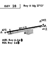
| Runways: | 07/25 |
| Longest Runway: | 07/25 is 2712 ft (827 m) long |
| Runways with an Instrument Approach: |
OCN Airport Runway Details
| Runway 07/25 | 2712 ft x 75 ft (827 m x 23 m) | |
| Surface: | Asphalt - Good condition - No special surface treatment | |
| Runway Edge Lights: | Medium Intensity | |
Runway Weight Bearing Capacity (in thousands of pounds) |
||
| Single Wheel Landing Gear: | 12.0 | |
Runway 07 |
Runway 25 |
|
Elevation: |
24.5 | 28.0 |
Latitude: |
33-13-02.3744N | 33-13-07.0550N |
Longitude: |
117-21-21.1528W | 117-20-49.7080W |
|
Runway True Alignment: |
080 | 260 |
Glide Path Angle: |
0.0 degrees | 0.0 degrees |
Traffic Pattern: |
Left | Right |
Runway Markings Type: |
Nonprecision Instrument | Nonprecision Instrument |
Runway Markings Condition: |
Good | Good |
Object at End: |
ROAD | HILL |
Object Height: |
15 | 210 |
Distance from End: |
420 | 5300 |
Object Centerline Offset: |
125 ft. left and right of centerline | 0 ft. left and right of centerline |
REIL: |
No | Yes |
Touchdown Lights: |
No | No |
Centerline Lights: |
No | No |
Services
Airframe Repair: |
Major |
Powerplant Repair: |
Major |
Bottled Oxygen: |
None |
Bulk Oxygen: |
High Pressure / Low Pressure |
Fuel Available: |
100LL |
Landing Fees: |
No |
Parking: |
Tiedowns available |
Maps & Diagrams
OCN Sectional
Flight Planning
at skyvector.com
at skyvector.com