Location
Latitude: |
47-12-30.9000N (47.208583) |
Longitude: |
119-19-08.9000W (-119.319139) |
Elevation: |
1188.6 feet MSL (362 m MSL) |
Magnetic Variation: |
14.5 E (as of April 2024 from WMM2020 model) |
Time Zone: |
UTC -8.0 (Standard Time) UTC -7.0 (Daylight Savings Time) |
From City: |
05 N.M. NW of Moses Lake, Washington |
Found On: |
Seattle Chart |
FAA Region: |
ANM |
Contacts
Manager: |
Publicly owned: |
| RICH MUELLER 7810 ANDREWS STREET NE MOSES LAKE, WA 98837-3204 509-762-5363 |
PORT OF MOSES LAKE 7810 ANDREWS STREET NE MOSES LAKE, WA 98837 509-762-5363 |
Operations
Airport Status: |
Operational |
Facility Use: |
Public |
Type: |
Airport |
Control tower: |
Yes |
Attendance (Months/Days/Hours): |
Months/Days/Hours ALL/ALL/ALL |
Boundary ARTCC: |
ZSE (Seattle) |
Responsible ARTCC: |
ZSE (Seattle) |
Lighting Schedule: |
SEE RMK |
Segmented Circle Indicator: |
Yes |
Traffic Pattern Altitude (MSL): |
2189 feet (667 m) |
NOTAMs Facility: |
MWH |
NOTAM-D Service: |
Yes |
International Airport of Entry: |
No |
Customs Landing Rights: |
No |
Military Landing Rights: |
Yes |
Civil/Military Joint Use: |
No |
Aircraft Rescue and Firefighting: |
Class IV ARFF Index: A Air Carrier Service: Not Scheduled Certification Date: 12/1974 |
Based Aircraft
| Single Engine: | 40 |
| Multi Engine: | 5 |
Annual Operations (as of 12/31/2018)
| Total Operations: | 77335 | |
| Commercial: | 7468 | 9.7% |
| Air Taxi: | 11028 | 14.3% |
| GA Local: | 34821 | 45.0% |
| GA Itinerant: | 12288 | 15.9% |
| Military Aircraft: | 11730 | 15.2% |
Communications
| CTAF: | 118.250 |
| Unicom: | 122.950 |
| Tower: | GRANT COUNTY 118.25 ;EAST 128.0 ;WEST 257.8 ;EAST & WEST Hrs: 0600-2200 |
| Ground: | 121.9 |
| Approach: | GRANT COUNTY 126.4 379.95 Hrs: 0600-2200 SEATTLE ARTCC 134.35 370.9 Hrs: 2200-0600 |
| Departure: | GRANT COUNTY 126.4 379.95 Hrs: 0600-2200 SEATTLE ARTCC 134.35 370.9 Hrs: 2200-0600 |
| ATIS: | 119.05 Hrs: 24 |
| ASOS: | 119.05 (509-762-5082) |
| EMERG: | 121.5 |
| EMERG: | 243.0 |
- APCH/DEP CTL SVC PRVDD BY SEATTLE ARTCC (ZSE) ON FREQS 126.1/291.6 (MARLIN RCAG) WHEN GRANT COUNTY APCH CTL (MHW) CLSD.
Fixed Based Operators (FBOs) & Fuel
(Click on a business for detail)
Please help us keep this information up to date. This is a FREE SERVICE just like everything else on Airport Guide! If you see that a business needs to be added, modified, or deleted please fill out our Update Form.
To add, modify, or delete a business click here.
Please help us keep this information up to date. This is a FREE SERVICE just like everything else on Airport Guide! If you see that a business needs to be added, modified, or deleted please fill out our Update Form.
Area Code: 509 |
| Business Name | Frequency | Phone | Fuel Grade |
|---|---|---|---|
| Air America Fuel & Service, Inc.
Update FBO info |
Unicom 122.95 | 762-2222, -2626 | 100LL, Jet A |
| Columbia Pacific Aviation
Update FBO info |
Unicom 122.95 | 762-1016 | 100LL, Jet A |
Flight Service Stations
| Primary | Alternate | |
| FSS on Field: | N | |
| FSS Name (ID): | Seattle(SEA) | |
| Frequency: | ||
| Toll Free Phone: | 1-800-WX-BRIEF |
Instrument Procedures / Charts
FAA Terminal Procedures valid from 0901Z 03/21/24 to 0901Z 04/18/24.
There are various types of charts available for an airport. They are listed in the Page Type column. Here is a legend for those types:
APD - Airport Diagram
DP - Departure Procedure Charts
HOT - Hot Spots
IAP - Instrument Approach Procedure Charts
MIN - Minimums
STAR - Standard Terminal Arrival Charts
| Page Type | Page Name | Volume | Action Since Last Cycle |
|---|---|---|---|
| APD | AIRPORT DIAGRAM | NW-1 | |
| HOT | HOT SPOT | NW-1 | |
| IAP | ILS OR LOC RWY 32R | NW-1 | |
| IAP | NDB RWY 32R | NW-1 | |
| IAP | RNAV (GPS) Y RWY 04 | NW-1 | |
| IAP | RNAV (GPS) Y RWY 14L | NW-1 | |
| IAP | RNAV (GPS) Y RWY 22 | NW-1 | |
| IAP | RNAV (GPS) Y RWY 32R | NW-1 | |
| IAP | RNAV (RNP) Z RWY 04 | NW-1 | |
| IAP | RNAV (RNP) Z RWY 14L | NW-1 | |
| IAP | RNAV (RNP) Z RWY 22 | NW-1 | |
| IAP | RNAV (RNP) Z RWY 32R | NW-1 | |
| IAP | VOR RWY 04 | NW-1 | |
| IAP | VOR RWY 22 | NW-1 | |
| IAP | VOR RWY 32R | NW-1 | |
| IAP | VOR-1 RWY 14L | NW-1 | |
| IAP | VOR-3 RWY 14L | NW-1 | |
| LAH | LAHSO | NW-1 | |
| MIN | ALTERNATE MINIMUMS | NW-1 | |
| MIN | TAKEOFF MINIMUMS | NW-1 |
Terminal Procedures are only available for airports in several countries with more being added all the time. If you are looking for a specific country's charts, please send an email to support(at)airportguide.com stating the country name. This will be used to prioritize the implementation.
Navigation Aids (Navaids) near MWH
| Dist (NM) | ID | Morse Code | Name | Type | Freq | True Hdg | Mag Hdg |
|---|---|---|---|---|---|---|---|
| 0.2 | MWH | _ _ . _ _ . . . . | Moses Lake | VOR-DME | 115.00 | 34 | 20 |
| 5.9 | MW | _ _ . _ _ | Pelly | NDB | 408 | 161 | 147 |
| 11.0 | EPH | . . _ _ . . . . . | Ephrata | VORTAC | 112.60 | 337 | 322 |
| 38.0 | EAT | . . _ _ | Wenatchee | VOR-DME | 111.00 | 287 | 272 |
| 47.8 | ELN | . . _ . . _ . | Ellensburg | VOR-DME | 117.90 | 257 | 242 |
| 56.9 | PSC | . _ _ . . . . _ . _ . | Pasco | VOR-DME | 113.75 | 171 | 157 |
| 59.5 | YK | _ . _ _ _ . _ | Donny | NDB | 371 | 226 | 211 |
| 60.0 | YKM | _ . _ _ _ . _ _ _ | Yakima | VORTAC | 116.00 | 230 | 215 |
| 71.5 | SKA | . . . _ . _ . _ | Fairchild | TACAN | 111.40 | 69 | 55 |
| 72.0 | GEG | _ _ . . _ _ . | Spokane | VORTAC | 115.50 | 72 | 58 |
| 75.1 | OMK | _ _ _ _ _ _ . _ | Omak | NDB | 219 | 353 | 338 |
| 76.7 | GEG | _ _ . . _ _ . | Spokane Intl | VOT | 109.60 | 70 | 56 |
| 77.3 | AL | . _ . _ . . | Trina | NDB | 353 | 142 | 128 |
| 79.5 | ALW | . _ . _ . . . _ _ | Walla Walla | VOR-DME | 116.40 | 147 | 133 |
| 80.9 | CRK | _ . _ . . _ . _ . _ | Canyon | NDB | 388 | 68 | 54 |
| 85.9 | SFF | . . . . . _ . . . _ . | Spokane/Felts Field | VOT | 114.00 | 70 | 56 |
| 89.1 | DPY | _ . . . _ _ . _ . _ _ | Deer Park | NDB | 365 | 58 | 44 |
| 91.6 | PUW | . _ _ . . . _ . _ _ | Pullman | VOR-DME | 117.15 | 109 | 95 |
| 92.0 | PDT | . _ _ . _ . . _ | Pendleton | VORTAC | 114.70 | 170 | 156 |
| 94.0 | PD | . _ _ . _ . . | Foris | NDB | 230 | 164 | 150 |
Nearby Airports with Fuel
Notices to Airmen (NOTAMS)
Remarks
| A110-1 | FLOCKS OF LRG BIRDS INVOF ARPT APRIL AND OCTOBER |
| A110-2 | HVY JET TRNG SFC TO 5000 FT WI 25 MI OF ARPT; PSBL WAKE TURBC FM LARGER ACFT USING RY 14L/32R AND RY 9/27. |
| A110-3 | RY 18/36 AVBL AS AIR CARRIER TWY MOVEMENT AREA ONLY. |
| A110-4 | TWY G UNLGTD. |
| A110-6 | RY 09/27 USED AS ASSAULT STRIP BY C-17 ACFT. |
| A110-7 | EXTENSIVE HVY MIL JET ACFT NIGHT TRAINING 1900PM-0300AM LCL DAILY. ANNOUNCE LANDING INTENTIONS ON CTAF AFTER ATCT CLSD. |
| A110-8 | RUNWAY 9-27 AND TAXIWAY FOXTROT NOT VISIBLE FROM THE ATCT. |
| A14 | AIRPORT DIRECTOR |
| A24 | LANDING FEES FOR ACFT OVER 12,500. |
| A26 | PPR FOR ACR OPNS WITH MORE THAN 30 PAX SEATS 2200-0600 509-762-5363. ARFF DEP STAFFED AND EQPTD AT INDEX D 24/7. |
| A30-09/27 | RY 9/27 CLSD EXC MIL OPERATIONS. |
| A30-14L/32R | RY 14L/32R CLSD NGTS 2200-0600 EXCEPT FOR SPECIAL MILITARY NGT TRAINING OPS. |
| A30-14R/32L | RY 14R/32L IS CLOSED TO ALL NIGHT OPERATIONS EXCEPT TAXIING. |
| A34-14L/32R | FIRST 10000 FT AER 32R GRVD 150 FT WIDE. |
| A40-09/27 | MIL LNDG ZONE LGTS ONLY. |
| A40-14L/32R | RY 14L/32R NSTD HIRL LCTD 50 FT FM RY EDGE MARKINGS. |
| A81-APT | ACTVT MALSR RWY 32R; REIL RWY 4; PAPI RWY 14L - CTAF. |
| E80 | US CUSTOMS USER FEE ARPT. |
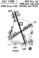
Runways
Runway Summary
| Runways: | 04/22 09/27 14L/32R 14R/32L 18/36 |
| Longest Runway: | 14L/32R is 13503 ft (4116 m) long |
| Runways with an Instrument Approach: | 32R |
MWH Airport Runway Details
| Runway 04/22 | 10000 ft x 100 ft (3048 m x 30 m) | |
| Runway Length Source: | 3RD PARTY SURVEY as of 05/13/2006 | |
| Surface: | Concrete - Good condition - Saw-cut or plastic grooved | |
| Runway Pavement Class: | 92 /R/B/W/T | |
| Runway Edge Lights: | Medium Intensity | |
Runway Weight Bearing Capacity (in thousands of pounds) |
||
| Single Wheel Landing Gear: | 75.0 | |
| Dual Wheel Landing Gear: | 100.0 | |
| Dual Tandem Wheel Landing Gear: | 175.0 | |
| Dual Dual Tandem Wheel Landing Gear: | 475.0 | |
Runway 04 |
Runway 22 |
|
Elevation: |
1188.6 | 1153.4 |
Latitude: |
47-11-48.2349N | 47-12-45.9838N |
Longitude: |
119-19-58.5325W | 119-18-01.0982W |
|
Runway True Alignment: |
054 | 234 |
Glide Path Angle: |
3.0 degrees | 3.0 degrees |
Traffic Pattern: |
Left | Right |
Runway Markings Type: |
Nonprecision Instrument | Nonprecision Instrument |
Runway Markings Condition: |
Good | Good |
Visual Glide Slope Indicators: |
4-Light PAPI On Left Side Of Runway | 4-Box VASI On Left Side Of Runway |
REIL: |
Yes | Yes |
Threshold Crossing Height: |
49 | 50 |
Declared Distances |
||
Take Off Run Avbl. (TORA): |
10000 | 10000 |
Take Off Distance Avbl. (TODA): |
10000 | 10000 |
Actual Stop Dist. Avbl. (ASDA): |
10000 | 10000 |
Landing Dist. Avbl. (LDA): |
10000 | 10000 |
| Runway 09/27 | 3500 ft x 90 ft (1067 m x 27 m) | |
| Runway Length Source: | 3RD PARTY SURVEY as of 05/13/2006 | |
| Surface: | Concrete - Good condition - Saw-cut or plastic grooved | |
| Runway Pavement Class: | 53 /R/B/W/T | |
| Runway Edge Lights: | Non-standard lighting system Intensity | |
Runway Weight Bearing Capacity (in thousands of pounds) |
||
| Single Wheel Landing Gear: | 100.0 | |
| Dual Wheel Landing Gear: | 150.0 | |
| Dual Tandem Wheel Landing Gear: | 270.0 | |
| Dual Dual Tandem Wheel Landing Gear: | 475.0 | |
Runway 09 |
Runway 27 |
|
Elevation: |
1162.2 | 1152.9 |
Latitude: |
47-13-03.5992N | 47-12-52.8239N |
Longitude: |
119-19-00.7701W | 119-18-12.6039W |
|
Runway True Alignment: |
108 | 288 |
Glide Path Angle: |
0.0 degrees | 0.0 degrees |
Traffic Pattern: |
Right | |
Declared Distances |
||
Take Off Run Avbl. (TORA): |
3500 | 3500 |
Take Off Distance Avbl. (TODA): |
3500 | 3500 |
Actual Stop Dist. Avbl. (ASDA): |
3500 | 3500 |
Landing Dist. Avbl. (LDA): |
3500 | 3500 |
| Runway 14L/32R | 13503 ft x 200 ft (4116 m x 61 m) | |
| Runway Length Source: | 3RD PARTY SURVEY as of 05/13/2006 | |
| Surface: | Concrete - Good condition - Saw-cut or plastic grooved | |
| Runway Pavement Class: | 103/R/B/W/T | |
| Runway Edge Lights: | High Intensity | |
Runway Weight Bearing Capacity (in thousands of pounds) |
||
| Single Wheel Landing Gear: | 85.0 | |
| Dual Wheel Landing Gear: | 155.0 | |
| Dual Tandem Wheel Landing Gear: | 320.0 | |
| Dual Dual Tandem Wheel Landing Gear: | 600.0 | |
Runway 14L |
Runway 32R |
|
Elevation: |
1168.4 | 1166.5 |
Latitude: |
47-13-32.3673N | 47-11-25.5351N |
Longitude: |
119-19-35.4306W | 119-18-35.4216W |
|
Runway True Alignment: |
162 | 342 |
ILS Type: |
ILS | |
Glide Path Angle: |
3.0 degrees | 3.0 degrees |
Traffic Pattern: |
Left | Right |
Runway Markings Type: |
Precision Instrument | Precision Instrument |
Runway Markings Condition: |
Good | Good |
Object at End: |
BLDG | |
Object Height: |
25 | |
Distance from End: |
1081 | |
Visual Glide Slope Indicators: |
4-Light PAPI On Left Side Of Runway | 4-Light PAPI On Left Side Of Runway |
Approach Light System: |
1,400 Foot Medium Intensity Approach Lighting System With Runway Alignment Indicator Lights | |
REIL: |
Yes | |
Threshold Crossing Height: |
75 | 76 |
Declared Distances |
||
Take Off Run Avbl. (TORA): |
13503 | 13503 |
Take Off Distance Avbl. (TODA): |
13503 | 13503 |
Actual Stop Dist. Avbl. (ASDA): |
13503 | 13492 |
Landing Dist. Avbl. (LDA): |
13503 | 13492 |
| Runway 14R/32L | 2936 ft x 75 ft (895 m x 23 m) | |
| Runway Length Source: | 3RD PARTY SURVEY as of 05/13/2006 | |
| Surface: | Concrete - Good condition - No special surface treatment | |
| Runway Pavement Class: | 107/R/B/W/T | |
Runway Weight Bearing Capacity (in thousands of pounds) |
||
| Single Wheel Landing Gear: | 100.0 | |
| Dual Wheel Landing Gear: | 200.0 | |
| Dual Tandem Wheel Landing Gear: | 400.0 | |
| Dual Dual Tandem Wheel Landing Gear: | 400.0 | |
Runway 14R |
Runway 32L |
|
Elevation: |
1167.8 | 1169.6 |
Latitude: |
47-13-26.4893N | 47-12-58.9103N |
Longitude: |
119-19-48.4477W | 119-19-35.3872W |
|
Runway True Alignment: |
162 | 342 |
Glide Path Angle: |
0.0 degrees | 0.0 degrees |
Traffic Pattern: |
Right | Left |
Runway Markings Type: |
Basic | Basic |
Runway Markings Condition: |
Good | Good |
Object at End: |
GND | |
Object Height: |
9 | |
Distance from End: |
620 | |
Declared Distances |
||
Take Off Run Avbl. (TORA): |
2936 | 2936 |
Take Off Distance Avbl. (TODA): |
2936 | 2936 |
Actual Stop Dist. Avbl. (ASDA): |
2936 | 2936 |
Landing Dist. Avbl. (LDA): |
2936 | 2936 |
| Runway 18/36 | 3327 ft x 75 ft (1014 m x 23 m) | |
| Runway Length Source: | 3RD PARTY SURVEY as of 05/13/2006 | |
| Surface: | Concrete - Good condition - No special surface treatment | |
| Runway Pavement Class: | 112/F/A/W/T | |
| Runway Edge Lights: | Medium Intensity | |
Runway Weight Bearing Capacity (in thousands of pounds) |
||
| Single Wheel Landing Gear: | 75.0 | |
| Dual Wheel Landing Gear: | 170.0 | |
| Dual Tandem Wheel Landing Gear: | 300.0 | |
| Dual Dual Tandem Wheel Landing Gear: | 400.0 | |
Runway 18 |
Runway 36 |
|
Elevation: |
1185.1 | 1184.8 |
Latitude: |
47-12-29.8063N | 47-11-58.6046N |
Longitude: |
119-19-47.4446W | 119-20-02.4514W |
|
Runway True Alignment: |
198 | 018 |
Glide Path Angle: |
0.0 degrees | 0.0 degrees |
Traffic Pattern: |
Right | Left |
Runway Markings Type: |
Basic | Basic |
Runway Markings Condition: |
Good | Good |
Services
Airframe Repair: |
Minor |
Powerplant Repair: |
Minor |
Bottled Oxygen: |
None |
Fuel Available: |
100LL |
Landing Fees: |
No |
Parking: |
Tiedowns available |
Maps & Diagrams
MWH Sectional
Flight Planning
at skyvector.com
at skyvector.com