Location
Latitude: |
46-18-20.3020N (46.305639) |
Longitude: |
119-18-15.0820W (-119.304189) |
Elevation: |
394.3 feet MSL (120 m MSL) |
Magnetic Variation: |
14.3 E (as of May 2024 from WMM2020 model) |
Time Zone: |
UTC -8.0 (Standard Time) UTC -7.0 (Daylight Savings Time) |
From City: |
02 N.M. NW of Richland, Washington |
Found On: |
Seattle Chart |
FAA Region: |
ANM |
Contacts
Manager: |
Publicly owned: |
| QUENTIN WRIGHT 3250 PORT OF BENTON BLVD RICHLAND, WA 99354 509-975-6352 |
PORT OF BENTON 3250 PORT OF BENTON BLVD RICHLAND, WA 99354 509-375-3060 |
Operations
Airport Status: |
Operational |
Facility Use: |
Public |
Type: |
Airport |
Activation Date: |
10/1950 |
Control tower: |
No |
Attendance (Months/Days/Hours): |
Months/Days/Hours ALL/ALL/0800-1800 |
Boundary ARTCC: |
ZSE (Seattle) |
Responsible ARTCC: |
ZSE (Seattle) |
Lighting Schedule: |
SEE RMK |
Segmented Circle Indicator: |
Yes |
Traffic Pattern Altitude (MSL): |
1394 feet (425 m) |
NOTAMs Facility: |
SEA |
NOTAM-D Service: |
Yes |
International Airport of Entry: |
No |
Customs Landing Rights: |
No |
Military Landing Rights: |
Yes |
Civil/Military Joint Use: |
No |
Based Aircraft
| Single Engine: | 113 |
| Multi Engine: | 4 |
| Jet Engine: | 2 |
| GA Helicopters: | 1 |
| Gliders: | 11 |
Annual Operations (as of 12/31/2021)
| Total Operations: | 45500 | |
| GA Local: | 33000 | 72.5% |
| GA Itinerant: | 12000 | 26.4% |
| Military Aircraft: | 500 | 1.1% |
Communications
| CTAF: | 122.700 |
| Unicom: | 122.700 |
| Approach: | SPOKANE 128.75 ;NORTH & WEST 128.75 ;NORTH & WEST SEATTLE ARTCC |
| Departure: | SPOKANE 128.75 ;NORTH & WEST 128.75 ;NORTH & WEST SEATTLE ARTCC |
| AWOS-3PT: | 132.675 (509-375-4247) |
- CD PRVDD BY SEATTLE RADIO ON 122.4.
- APCH/DEP CTL SVC PROVDD BY SEATTLE ARTCC (ZSE) ON 132.6/269.35 (YAKIMA RCAG), WHEN GEG APCH CLSD.
Fixed Based Operators (FBOs) & Fuel
(Click on a business for detail)
Please help us keep this information up to date. This is a FREE SERVICE just like everything else on Airport Guide! If you see that a business needs to be added, modified, or deleted please fill out our Update Form.
To add, modify, or delete a business click here.
Please help us keep this information up to date. This is a FREE SERVICE just like everything else on Airport Guide! If you see that a business needs to be added, modified, or deleted please fill out our Update Form.
Area Code: 509 |
| Business Name | Frequency | Phone | Fuel Grade |
|---|---|---|---|
| MacPherson Aviation
Update FBO info |
946-9799 | ||
| Richland Skysports Update FBO info |
Unicom 122.7 | 946-3483 | 100LL |
Flight Service Stations
| Primary | Alternate | |
| FSS on Field: | N | |
| FSS Name (ID): | Seattle(SEA) | |
| Frequency: | ||
| Toll Free Phone: | 1-800-WX-BRIEF |
Instrument Procedures / Charts
FAA Terminal Procedures valid from 0901Z 03/21/24 to 0901Z 04/18/24.
There are various types of charts available for an airport. They are listed in the Page Type column. Here is a legend for those types:
APD - Airport Diagram
DP - Departure Procedure Charts
HOT - Hot Spots
IAP - Instrument Approach Procedure Charts
MIN - Minimums
STAR - Standard Terminal Arrival Charts
| Page Type | Page Name | Volume | Action Since Last Cycle |
|---|---|---|---|
| IAP | LOC RWY 19 | NW-1 | |
| IAP | RNAV (GPS) RWY 26 | NW-1 | |
| IAP | RNAV (GPS) Y RWY 19 | NW-1 | |
| IAP | RNAV (GPS) Z RWY 19 | NW-1 | |
| IAP | VOR/DME-A | NW-1 | |
| MIN | TAKEOFF MINIMUMS | NW-1 |
Terminal Procedures are only available for airports in several countries with more being added all the time. If you are looking for a specific country's charts, please send an email to support(at)airportguide.com stating the country name. This will be used to prioritize the implementation.
Navigation Aids (Navaids) near RLD
| Dist (NM) | ID | Morse Code | Name | Type | Freq | True Hdg | Mag Hdg |
|---|---|---|---|---|---|---|---|
| 8.0 | PSC | . _ _ . . . . _ . _ . | Pasco | VOR-DME | 113.75 | 105 | 91 |
| 39.5 | PDT | . _ _ . _ . . _ | Pendleton | VORTAC | 114.70 | 157 | 143 |
| 43.7 | PD | . _ _ . _ . . | Foris | NDB | 230 | 146 | 132 |
| 44.0 | ALW | . _ . _ . . . _ _ | Walla Walla | VOR-DME | 116.40 | 106 | 92 |
| 46.1 | YK | _ . _ _ _ . _ | Donny | NDB | 371 | 287 | 273 |
| 46.6 | AL | . _ . _ . . | Trina | NDB | 353 | 99 | 85 |
| 48.6 | MW | _ _ . _ _ | Pelly | NDB | 408 | 1 | 347 |
| 49.8 | YKM | _ . _ _ _ . _ _ _ | Yakima | VORTAC | 116.00 | 289 | 275 |
| 54.3 | MWH | _ _ . _ _ . . . . | Moses Lake | VOR-DME | 115.00 | 359 | 345 |
| 64.2 | ELN | . . _ . . _ . | Ellensburg | VOR-DME | 117.90 | 312 | 298 |
| 64.5 | EPH | . . _ _ . . . . . | Ephrata | VORTAC | 112.60 | 355 | 341 |
| 75.5 | EAT | . . _ _ | Wenatchee | VOR-DME | 111.00 | 330 | 316 |
| 80.5 | LGD | . _ . . _ _ . _ . . | La Grande | NDB | 296 | 135 | 121 |
| 82.9 | LTJ | . _ . . _ . _ _ _ | Klickitat | VOR-DME | 112.30 | 245 | 231 |
| 88.7 | PUW | . _ _ . . . _ . _ _ | Pullman | VOR-DME | 117.15 | 74 | 60 |
Nearby Airports with Fuel
Notices to Airmen (NOTAMS)
Remarks
| A110-3 | ROAD 550' WEST APCH END RY 08. |
| A110-5 | (E94) SAWRS;DRCT PHONE LINE TO FSS. |
| A110-6 | PREFERRED RWY 01-19 IN CALM WIND CONDITIONS. |
| A110-7 | AIRFIELD CONDS UNMON NGTS, WKENDS AND HOLS. |
| A43-01 | PAPI UNUSBL BYD 3.0 NM FM THR FOR TRRN ON RIGHT SIDE OF RWY CNTRLN AT APRXLY 3.5 NM. |
| A43-08 | UNUSBL BYD 8 DEG RIGHT OF CNTRLN. |
| A58-01 | CLOSE-IN OBSTN GND. |
| A70-FUEL-10 | 0LL FUEL BY MAJOR CREDIT CARD - 24 HR AVAILABILITY. |
| A75 | PILOTS BRING OWN ROPES. |
| A81-APT | ACTVT MALS RWY 19; REIL RWYS 01 & 19; MIRL RWY 01/19 & 08/26 - CTAF. VASI RWY 26 & PAPI RWYS 01, 08 & 19 OPR 24 HRS. |
Runways
Runway Summary
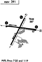
| Runways: | 01/19 08/26 |
| Longest Runway: | 01/19 is 4009 ft (1222 m) long |
| Runways with an Instrument Approach: | 19 |
RLD Airport Runway Details
| Runway 01/19 | 4009 ft x 75 ft (1222 m x 23 m) | |
| Runway Length Source: | 3RD PARTY SURVEY as of 02/27/2020 | |
| Surface: | Asphalt - Good condition - No special surface treatment | |
| Runway Edge Lights: | Medium Intensity | |
Runway Weight Bearing Capacity (in thousands of pounds) |
||
| Single Wheel Landing Gear: | 30.0 | |
| Dual Wheel Landing Gear: | 45.0 | |
| Dual Tandem Wheel Landing Gear: | 70.0 | |
Runway 01 |
Runway 19 |
|
Elevation: |
391.5 | 389.0 |
Latitude: |
46-17-59.8609N | 46-18-35.5501N |
Longitude: |
119-18-30.4127W | 119-18-05.7522W |
|
Runway True Alignment: |
026 | 206 |
ILS Type: |
LOC/DME | |
Glide Path Angle: |
3.0 degrees | 3.0 degrees |
Traffic Pattern: |
Left | Right |
Runway Markings Type: |
Nonprecision Instrument | Nonprecision Instrument |
Runway Markings Condition: |
Good | Good |
Object at End: |
ANT | POLE |
Object Height: |
13 | 24 |
Object Marked/Lighted?: |
Marked | |
Distance from End: |
396 | 795 |
Object Centerline Offset: |
258 ft. right of centerline | 444 ft. left of centerline |
Visual Glide Slope Indicators: |
2-Light PAPI On Left Side Of Runway | 2-Light PAPI On Left Side Of Runway |
Approach Light System: |
1,400 Foot Medium Intensity Approach Lighting System | |
REIL: |
Yes | Yes |
Threshold Crossing Height: |
30 | 30 |
| Runway 08/26 | 4001 ft x 100 ft (1220 m x 30 m) | |
| Runway Length Source: | 3RD PARTY SURVEY as of 02/27/2020 | |
| Surface: | Asphalt - Good condition - No special surface treatment | |
| Runway Edge Lights: | Medium Intensity | |
Runway Weight Bearing Capacity (in thousands of pounds) |
||
| Single Wheel Landing Gear: | 30.0 | |
| Dual Wheel Landing Gear: | 45.0 | |
| Dual Tandem Wheel Landing Gear: | 70.0 | |
Runway 08 |
Runway 26 |
|
Elevation: |
394.3 | 388.1 |
Latitude: |
46-18-24.7739N | 46-18-21.0306N |
Longitude: |
119-18-40.4419W | 119-17-43.7084W |
|
Runway True Alignment: |
095 | 275 |
Glide Path Angle: |
3.0 degrees | 3.0 degrees |
Traffic Pattern: |
Left | Right |
Runway Markings Type: |
Nonprecision Instrument | Nonprecision Instrument |
Runway Markings Condition: |
Good | Good |
Object at End: |
RR | |
Object Height: |
16 | |
Distance from End: |
573 | |
Object Centerline Offset: |
258 ft. right of centerline | 444 ft. left of centerline |
Visual Glide Slope Indicators: |
2-Light PAPI On Left Side Of Runway | 4-Box VASI On Left Side Of Runway |
Threshold Crossing Height: |
40 | 52 |
Services
Airframe Repair: |
Minor |
Powerplant Repair: |
Minor |
Bottled Oxygen: |
None |
Bulk Oxygen: |
None |
Fuel Available: |
100LL, Jet A |
Landing Fees: |
No |
Parking: |
Tiedowns available |
Maps & Diagrams
RLD Sectional
Flight Planning
at skyvector.com
at skyvector.com