Location
Latitude: |
38-30-35.3000N (38.509806) |
Longitude: |
107-53-39.3000W (-107.89425) |
Elevation: |
5758.5 feet MSL (1755 m MSL) |
Magnetic Variation: |
8.9 E (as of April 2024 from WMM2020 model) |
Time Zone: |
UTC -7.0 (Standard Time) UTC -6.0 (Daylight Savings Time) |
From City: |
01 N.M. NW of Montrose, Colorado |
Found On: |
Denver Chart |
FAA Region: |
ANM |
Contacts
Manager: |
Publicly owned: |
| LLOYD ARNOLD 2100 AIRPORT ROAD MONTROSE, CO 81401 970-249-3433 |
MONTROSE COUNTY 161 S. TOWNSEND MONTROSE, CO 81401 970-249-7755 |
Operations
Airport Status: |
Operational |
Facility Use: |
Public |
Type: |
Airport |
Activation Date: |
09/1946 |
Control tower: |
No |
Attendance (Months/Days/Hours): |
Months/Days/Hours DEC16-MAR31/ALL/0500-2100 |
Boundary ARTCC: |
ZDV (Denver) |
Responsible ARTCC: |
ZDV (Denver) |
Lighting Schedule: |
SEE RMK |
Segmented Circle Indicator: |
Yes |
Traffic Pattern Altitude (MSL): |
6758 feet (2060 m) |
NOTAMs Facility: |
MTJ |
NOTAM-D Service: |
Yes |
International Airport of Entry: |
No |
Customs Landing Rights: |
No |
Military Landing Rights: |
Yes |
Civil/Military Joint Use: |
No |
Aircraft Rescue and Firefighting: |
Class I ARFF Index: B Air Carrier Service: Scheduled Certification Date: 05/1973 |
Based Aircraft
| Single Engine: | 70 |
| Multi Engine: | 13 |
| Jet Engine: | 3 |
| GA Helicopters: | 3 |
| Gliders: | 3 |
| Ultralights: | 1 |
Annual Operations (as of 12/31/2022)
| Total Operations: | 23414 | |
| Commercial: | 6034 | 25.8% |
| Air Taxi: | 250 | 1.1% |
| GA Local: | 7259 | 31.0% |
| GA Itinerant: | 9652 | 41.2% |
| Military Aircraft: | 219 | 0.9% |
Communications
| CTAF: | 122.800 |
| Unicom: | 122.800 |
| ASOS: | 135.225 (970-249-1534) |
- APCH/DEP CTLSVC PRVDD BY DENVER ARTCC (ZDV) ON 127.1(GRAND MESA/A/ RCAG & MONTROSE RCAG) 343.65 (MESA/A RCAG).
Fixed Based Operators (FBOs) & Fuel
(Click on a business for detail)
Please help us keep this information up to date. This is a FREE SERVICE just like everything else on Airport Guide! If you see that a business needs to be added, modified, or deleted please fill out our Update Form.
To add, modify, or delete a business click here.
Please help us keep this information up to date. This is a FREE SERVICE just like everything else on Airport Guide! If you see that a business needs to be added, modified, or deleted please fill out our Update Form.
Area Code: 970 |
| Business Name | Frequency | Phone | Fuel Grade |
|---|---|---|---|
| Berkshire Instrument Overhaul
Update FBO info |
240-9606 | ||
| Black Canyon Air
Update FBO info |
249-8315 | ||
| Century Aviation
Update FBO info |
249-2013 | ||
| High Country Helicopters
Update FBO info |
|||
| MTJ Air Service
Update FBO info |
Unicom 122.8 | 249-0592 | 100LL, Jet A |
| Northstar Aviation
Update FBO info |
240-8410 |
Flight Service Stations
| Primary | Alternate | |
| FSS on Field: | N | |
| FSS Name (ID): | Denver(DEN) | |
| Frequency: | ||
| Toll Free Phone: | 1-800-WX-BRIEF |
Instrument Procedures / Charts
FAA Terminal Procedures valid from 0901Z 03/21/24 to 0901Z 04/18/24.
There are various types of charts available for an airport. They are listed in the Page Type column. Here is a legend for those types:
APD - Airport Diagram
DP - Departure Procedure Charts
HOT - Hot Spots
IAP - Instrument Approach Procedure Charts
MIN - Minimums
STAR - Standard Terminal Arrival Charts
| Page Type | Page Name | Volume | Action Since Last Cycle |
|---|---|---|---|
| APD | AIRPORT DIAGRAM | SW-1 | |
| DP | BLUE MESA THREE | SW-1 | |
| DP | BRICK FOUR | SW-1 | |
| IAP | ILS OR LOC RWY 17 | SW-1 | |
| IAP | RNAV (GPS) RWY 13 | SW-1 | |
| IAP | RNAV (GPS) RWY 17 | SW-1 | |
| IAP | RNAV (GPS) RWY 35 | SW-1 | |
| IAP | VOR RWY 13 | SW-1 | |
| MIN | ALTERNATE MINIMUMS | SW-1 | |
| MIN | TAKEOFF MINIMUMS | SW-1 | |
| ODP | MONTROSE TWO (OBSTACLE) | SW-1 |
Terminal Procedures are only available for airports in several countries with more being added all the time. If you are looking for a specific country's charts, please send an email to support(at)airportguide.com stating the country name. This will be used to prioritize the implementation.
Navigation Aids (Navaids) near MTJ
| Dist (NM) | ID | Morse Code | Name | Type | Freq | True Hdg | Mag Hdg |
|---|---|---|---|---|---|---|---|
| 0.3 | MTJ | _ _ _ . _ _ _ | Montrose | VOR-DME | 117.10 | 229 | 220 |
| 33.0 | ETL | . _ . _ . . | Cones | VOR-DME | 110.20 | 211 | 202 |
| 40.3 | HBU | . . . . _ . . . . . _ | Blue Mesa | VOR-DME | 114.90 | 94 | 85 |
| 53.4 | JNC | . _ _ _ _ . _ . _ . | Grand Junction | VOR-DME | 112.40 | 308 | 299 |
| 61.6 | RIL | . _ . . . . _ . . | Rifle | VOR-DME | 113.35 | 7 | 358 |
| 64.2 | RDY | . _ . _ . . _ . _ _ | Sardy | TACAN | 114.30 | 48 | 39 |
| 64.5 | DVC | _ . . . . . _ _ . _ . | Dove Creek | VORTAC | 114.60 | 229 | 220 |
| 72.7 | DBL | _ . . _ . . . . _ . . | Red Table | VOR-DME | 113.00 | 39 | 30 |
| 74.3 | CEZ | _ . _ . . _ _ . . | Cortez | VOR-DME | 114.35 | 205 | 196 |
| 79.3 | SXW | . . . _ . . _ . _ _ | Snow | VOR-DME | 109.20 | 31 | 22 |
| 81.7 | DRO | _ . . . _ . _ _ _ | Durango | VOR-DME | 116.55 | 175 | 166 |
| 88.2 | OAB | _ _ _ . _ _ . . . | Moab | VOR-DME | 109.80 | 280 | 271 |
| 93.5 | EKR | . _ . _ . _ . | Meeker | VOR-DME | 115.20 | 359 | 350 |
Nearby Airports with Fuel
Notices to Airmen (NOTAMS)
Remarks
| A110-10 | FOR CD, IFUN TO CTC ON DENVER ARTCC APP/DEP CTL FREQ, CTC DENVER ARTCC AT 303-651-4257. |
| A110-3 | BIRDS & WILDLIFE ON & INVOF ARPT. |
| A110-6 | ACR ACES TRML RAMP VIA TWY C; OUBD TFC TWY D. |
| A110-8 | RAMP CNCTR ADJ TO T HNGR ROW CLSD INDEF; TWY E & E6 CLSD EXC WINGSPAN LESS THAN 78 FT. |
| A110-9 | TWY B LTD TO SNGL WHEEL MAX 80000 LB; DBL WHEEL MAX 105000 LB; DBL TAND WHEEL MAX 170000 LB. |
| A16 | 970-249-3203 EXT 5811. |
| A26 | UNSKED ACR OPS MORE THAN 30 PAX SEATS 24 HR PPR - AMGR. |
| A30-13/31 | RCMDD FOR APCH SPD LESS THAN 121 KT. |
| A30-17/35 | RCMDD FOR APCH SPD MORE THAN 121 KT. |
| A30A-13 | PREFERRED LNDG RWY. |
| A30A-17 | PREFERRED LNDG RWY. |
| A30A-31 | PREFERRED TKOF RWY. |
| A30A-35 | PREFERRED TKOF RWY. |
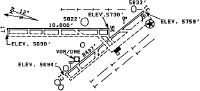
| A57-13 | THREE MKD & LGTD POLES 1.5 MI NW RWY END. |
| A81-APT | ACTVT MALSR RWY 17; REIL RWY 31 & 35; HIRL RWY 13/31 & 17/35 - CTAF. |
Runways
Runway Summary
| Runways: | 13/31 17/35 |
| Longest Runway: | 17/35 is 10000 ft (3048 m) long |
| Runways with an Instrument Approach: | 17 |
MTJ Airport Runway Details
| Runway 13/31 | 7510 ft x 100 ft (2289 m x 30 m) | |
| Runway Length Source: | 3RD PARTY SURVEY as of 05/17/2016 | |
| Surface: | Asphalt - Good condition - Saw-cut or plastic grooved | |
| Runway Pavement Class: | 13 /F/D/X/T | |
| Runway Edge Lights: | High Intensity | |
Runway Weight Bearing Capacity (in thousands of pounds) |
||
| Single Wheel Landing Gear: | 65.0 | |
| Dual Wheel Landing Gear: | 90.0 | |
| Dual Tandem Wheel Landing Gear: | 150.0 | |
Runway 13 |
Runway 31 |
|
Elevation: |
5698.5 | 5758.5 |
Latitude: |
38-30-33.2075N | 38-29-36.8403N |
Longitude: |
107-54-17.4856W | 107-53-16.0498W |
|
Runway True Alignment: |
139 | 319 |
Glide Path Angle: |
3.0 degrees | 3.0 degrees |
Traffic Pattern: |
Left | Left |
Runway Markings Type: |
Nonprecision Instrument | Nonprecision Instrument |
Runway Markings Condition: |
Good | Good |
Object at End: |
TREE | |
Object Height: |
41 | |
Distance from End: |
2050 | |
Object Centerline Offset: |
575 ft. right of centerline | |
Visual Glide Slope Indicators: |
4-Box VASI On Left Side Of Runway | 4-Box VASI On Left Side Of Runway |
REIL: |
No | Yes |
Threshold Crossing Height: |
43 | 43 |
Declared Distances |
||
Take Off Run Avbl. (TORA): |
7510 | 7510 |
Take Off Distance Avbl. (TODA): |
7510 | 7510 |
Actual Stop Dist. Avbl. (ASDA): |
7510 | 7510 |
Landing Dist. Avbl. (LDA): |
7510 | 7510 |
| Runway 17/35 | 10000 ft x 150 ft (3048 m x 46 m) | |
| Runway Length Source: | 3RD PARTY SURVEY as of 05/17/2016 | |
| Surface: | Asphalt - Good condition - Saw-cut or plastic grooved | |
| Runway Pavement Class: | 61 /F/C/X/T | |
| Runway Edge Lights: | High Intensity | |
Runway Weight Bearing Capacity (in thousands of pounds) |
||
| Single Wheel Landing Gear: | 75.0 | |
| Dual Wheel Landing Gear: | 190.0 | |
| Dual Tandem Wheel Landing Gear: | 265.0 | |
Runway 17 |
Runway 35 |
|
Elevation: |
5693.7 | 5734.1 |
Latitude: |
38-31-47.3939N | 38-30-08.5719N |
Longitude: |
107-53-33.8635W | 107-53-33.4650W |
|
Runway True Alignment: |
180 | 360 |
ILS Type: |
LOC/GS | |
Glide Path Angle: |
3.0 degrees | 3.0 degrees |
Runway Markings Type: |
Precision Instrument | Precision Instrument |
Runway Markings Condition: |
Good | Good |
Object Centerline Offset: |
575 ft. right of centerline | |
Visual Glide Slope Indicators: |
4-Light PAPI On Left Side Of Runway | 4-Light PAPI On Left Side Of Runway |
Approach Light System: |
1,400 Foot Medium Intensity Approach Lighting System With Runway Alignment Indicator Lights | |
REIL: |
No | Yes |
Threshold Crossing Height: |
55 | 41 |
Declared Distances |
||
Take Off Run Avbl. (TORA): |
10000 | 10000 |
Take Off Distance Avbl. (TODA): |
10000 | 10000 |
Actual Stop Dist. Avbl. (ASDA): |
10000 | 10000 |
Landing Dist. Avbl. (LDA): |
10000 | 10000 |
Services
Bottled Oxygen: |
None |
Fuel Available: |
100LL, Jet A+ |
Landing Fees: |
No |
Parking: |
Tiedowns available |
Other Services: |
Aircraft restoration |
Maps & Diagrams
MTJ Sectional
Flight Planning
at skyvector.com
at skyvector.com