Location
Latitude: |
37-18-10.8090N (37.303003) |
Longitude: |
108-37-40.9590W (-108.628044) |
Elevation: |
5917.6 feet MSL (1804 m MSL) |
Magnetic Variation: |
9.1 E (as of April 2024 from WMM2020 model) |
Time Zone: |
UTC -7.0 (Standard Time) UTC -6.0 (Daylight Savings Time) |
From City: |
03 N.M. SW of Cortez, Colorado |
Found On: |
Denver Chart |
FAA Region: |
ANM |
Contacts
Manager: |
Publicly owned: |
| JEREMY PATTON 123 ROGER SMITH AVE. CORTEZ, CO 81321 970-565-7458 |
CITY OF CORTEZ 123 ROGER SMITH AVE. CORTEZ, CO 81321 (970) 565-7458 |
Operations
Airport Status: |
Operational |
Facility Use: |
Public |
Type: |
Airport |
Activation Date: |
07/1949 |
Control tower: |
No |
Attendance (Months/Days/Hours): |
Months/Days/Hours ALL/ALL/DAWN-DUSK |
Boundary ARTCC: |
ZDV (Denver) |
Responsible ARTCC: |
ZDV (Denver) |
Lighting Schedule: |
SEE RMK |
Segmented Circle Indicator: |
Yes |
Traffic Pattern Altitude (MSL): |
6918 feet (2109 m) |
NOTAMs Facility: |
CEZ |
NOTAM-D Service: |
Yes |
International Airport of Entry: |
No |
Customs Landing Rights: |
No |
Military Landing Rights: |
Yes |
Civil/Military Joint Use: |
No |
Based Aircraft
| Single Engine: | 38 |
| Multi Engine: | 1 |
| Jet Engine: | 1 |
| GA Helicopters: | 3 |
Annual Operations (as of 12/31/2020)
| Total Operations: | 9834 | |
| Air Taxi: | 1304 | 13.3% |
| GA Local: | 3000 | 30.5% |
| GA Itinerant: | 5500 | 55.9% |
| Military Aircraft: | 30 | 0.3% |
Communications
| CTAF: | 122.800 |
| Unicom: | 122.800 |
| ASOS: | 135.625 (970-564-0193) |
- APCH/DEP CTL SVC PRVDD BY DEN ARTCC (ZDV) ON FREQS 118.575/348.7 (CORTEZ RCAG).
Fixed Based Operators (FBOs) & Fuel
(Click on a business for detail)
Please help us keep this information up to date. This is a FREE SERVICE just like everything else on Airport Guide! If you see that a business needs to be added, modified, or deleted please fill out our Update Form.
To add, modify, or delete a business click here.
Please help us keep this information up to date. This is a FREE SERVICE just like everything else on Airport Guide! If you see that a business needs to be added, modified, or deleted please fill out our Update Form.
Area Code: 970 |
| Business Name | Frequency | Phone | Fuel Grade |
|---|---|---|---|
| Cortez Flying Service
Update FBO info |
Unicom 122.8 | 565-3721 | 100LL, Jet A |
Flight Service Stations
| Primary | Alternate | |
| FSS on Field: | N | |
| FSS Name (ID): | Denver(DEN) | |
| Frequency: | ||
| Toll Free Phone: | 1-800-WX-BRIEF |
Instrument Procedures / Charts
FAA Terminal Procedures valid from 0901Z 03/21/24 to 0901Z 04/18/24.
There are various types of charts available for an airport. They are listed in the Page Type column. Here is a legend for those types:
APD - Airport Diagram
DP - Departure Procedure Charts
HOT - Hot Spots
IAP - Instrument Approach Procedure Charts
MIN - Minimums
STAR - Standard Terminal Arrival Charts
| Page Type | Page Name | Volume | Action Since Last Cycle |
|---|---|---|---|
| APD | AIRPORT DIAGRAM | SW-1 | |
| DP | CORTEZ TWO | SW-1 | |
| IAP | RNAV (GPS) RWY 03 | SW-1 | |
| IAP | RNAV (GPS) Y RWY 21 | SW-1 | |
| IAP | RNAV (GPS) Z RWY 21 | SW-1 | |
| IAP | VOR RWY 21 | SW-1 | |
| MIN | ALTERNATE MINIMUMS | SW-1 | |
| MIN | TAKEOFF MINIMUMS | SW-1 | |
| ODP | LEDVE ONE (OBSTACLE) | SW-1 |
Terminal Procedures are only available for airports in several countries with more being added all the time. If you are looking for a specific country's charts, please send an email to support(at)airportguide.com stating the country name. This will be used to prioritize the implementation.
Navigation Aids (Navaids) near CEZ
| Dist (NM) | ID | Morse Code | Name | Type | Freq | True Hdg | Mag Hdg |
|---|---|---|---|---|---|---|---|
| 6.1 | CEZ | _ . _ . . _ _ . . | Cortez | VOR-DME | 114.35 | 31 | 22 |
| 33.6 | DVC | _ . . . . . _ _ . _ . | Dove Creek | VORTAC | 114.60 | 334 | 325 |
| 41.8 | RSK | . _ . . . . _ . _ | Rattlesnake | VORTAC | 115.30 | 142 | 133 |
| 42.9 | DRO | _ . . . _ . _ _ _ | Durango | VOR-DME | 116.55 | 101 | 92 |
| 47.6 | ETL | . _ . _ . . | Cones | VOR-DME | 110.20 | 21 | 12 |
| 80.0 | MTJ | _ _ _ . _ _ _ | Montrose | VOR-DME | 117.10 | 25 | 16 |
Nearby Airports with Fuel
| Dist (NM) | Name (Airport IDs) | True Hdg | Mag Hdg | Fuel Grade |
|---|---|---|---|---|
| 36.7 | Animas Air Park Airport (AMK 00C) |
99 | 90 | 100LL, Jet A |
| 38.7 | Four Corners Regional Airport (FMN KFMN FMN) |
150 | 141 | 100LL, Jet A, Jet A-1+ |
| 42.7 | Durango-La Plata County Airport (DRO KDRO DRO) |
102 | 93 | 100LL, Jet A |
| 44.1 | Blanding Municipal Airport (BDG KBDG BDG) |
292 | 283 | 100LL, Jet A |
| 50.7 | Monticello Airport (U64) |
318 | 309 | 100LL, Jet A |
| 51.9 | Telluride Regional Airport (TEX KTEX TEX) |
40 | 31 | 100LL, Jet A |
| 56.2 | Hopkins Field Airport (KAIB AIB) |
3 | 354 | 100LL, Jet A |
| 75.0 | Stevens Field Airport (PGO KPSO PSO) |
90 | 82 | 100LL, Jet A |
| 80.3 | Montrose Regional Airport (MTJ KMTJ MTJ) |
25 | 16 | 100LL, Jet A+ |
| 92.7 | Cal Black Meml Airport (U96) |
275 | 265 | 100LL, Jet A |
| 92.9 | Blake Field Airport (KAJZ AJZ) |
16 | 7 | 100LL, Jet A |
| 96.1 | Crawford Airport (99V) |
28 | 19 | 100LL |
Notices to Airmen (NOTAMS)
Remarks
| A110-1 | ACFT GTR THAN 20000 LBS DUAL WHEEL RSTRD TO TWY CONNECTOR A2; BACK TAXI ON RWY TO & FM TWY CONNECTOR A2 TO APRON. |
| A110-2 | FOR CD CTC DENVER ARTCC ON FREQ. IF UNA, CTC FSS ON FREQ VIA RCO. IF UNA, CTC DENVER ARTCC AT 303-651-4257. |
| A26 | PPR FOR UNSKED ACR OPS WITH MORE THAN 30 PAX SEATS - AMGR. |
| A55-03 | 133 FT POLE ON CNTRLN. |
| A81-APT | ACTVT REIL RWY 03 & 21; MIRL RWY 03/21 - CTAF. PAPI RWY 03 & VASI RWY 21 ON CONSLY. |
Runways
Runway Summary
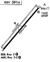
| Runways: | 03/21 |
| Longest Runway: | 03/21 is 7205 ft (2196 m) long |
| Runways with an Instrument Approach: |
CEZ Airport Runway Details
| Runway 03/21 | 7205 ft x 100 ft (2196 m x 30 m) | |
| Runway Length Source: | 3RD PARTY SURVEY as of 06/07/2021 | |
| Surface: | Asphalt - Good condition - Porous friction course | |
| Runway Edge Lights: | Medium Intensity | |
Runway Weight Bearing Capacity (in thousands of pounds) |
||
| Single Wheel Landing Gear: | 40.0 | |
| Dual Wheel Landing Gear: | 56.0 | |
Runway 03 |
Runway 21 |
|
Elevation: |
5913.2 | 5909.2 |
Latitude: |
37-17-44.1552N | 37-18-37.4612N |
Longitude: |
108-38-10.5121W | 108-37-11.4010W |
|
Runway True Alignment: |
042 | 222 |
Glide Path Angle: |
3.0 degrees | 3.0 degrees |
Traffic Pattern: |
Left | Left |
Runway Markings Type: |
Nonprecision Instrument | Nonprecision Instrument |
Runway Markings Condition: |
Good | Good |
Object at End: |
TREES | ROAD |
Object Height: |
59 | 16 |
Distance from End: |
2000 | 680 |
Object Centerline Offset: |
350 ft. right of centerline | 300 ft. right of centerline |
Visual Glide Slope Indicators: |
4-Light PAPI On Left Side Of Runway | 4-Box VASI On Left Side Of Runway |
REIL: |
Yes | Yes |
Threshold Crossing Height: |
47 | 50 |
Declared Distances |
||
Take Off Run Avbl. (TORA): |
7205 | 7205 |
Take Off Distance Avbl. (TODA): |
7205 | 7205 |
Actual Stop Dist. Avbl. (ASDA): |
7205 | 7205 |
Landing Dist. Avbl. (LDA): |
7205 | 7205 |
Services
Airframe Repair: |
Minor |
Powerplant Repair: |
Minor |
Landing Fees: |
No |
Parking: |
Hangars and tiedowns available |
Other Services: |
Glider instruction |
Maps & Diagrams
CEZ Sectional
Flight Planning
at skyvector.com
at skyvector.com