Location
Latitude: |
39-30-21.6000N (39.506) |
Longitude: |
107-18-32.7000W (-107.309083) |
Elevation: |
5916.0 feet MSL (1803 m MSL) |
Magnetic Variation: |
8.8 E (as of April 2024 from WMM2020 model) |
Time Zone: |
UTC -7.0 (Standard Time) UTC -6.0 (Daylight Savings Time) |
From City: |
03 N.M. S of Glenwood Springs, Colorado |
Found On: |
Denver Chart |
FAA Region: |
ANM |
Contacts
Manager: |
Publicly owned: |
| MEREDITH FOX 100 WULFSOHN ROAD GLENWOOD SPRINGS, CO 81601 970-445-0965 |
CITY OF GLENWOOD SPRINGS 100 WULFSOHN ROAD GLENWOOD SPRINGS, CO 81601 970-384-6307 |
Operations
Airport Status: |
Operational |
Facility Use: |
Public |
Type: |
Airport |
Activation Date: |
10/1944 |
Control tower: |
No |
Attendance (Months/Days/Hours): |
Months/Days/Hours ALL/MON-FRI/0800-1700 |
Boundary ARTCC: |
ZDV (Denver) |
Responsible ARTCC: |
ZDV (Denver) |
Segmented Circle Indicator: |
No |
Traffic Pattern Altitude (MSL): |
6916 feet (2108 m) |
NOTAMs Facility: |
DEN |
NOTAM-D Service: |
Yes |
International Airport of Entry: |
No |
Customs Landing Rights: |
No |
Military Landing Rights: |
No |
Civil/Military Joint Use: |
No |
Based Aircraft
| Single Engine: | 62 |
| Multi Engine: | 3 |
| GA Helicopters: | 5 |
| Gliders: | 1 |
| Ultralights: | 2 |
Annual Operations (as of 12/31/2021)
| Total Operations: | 20999 | |
| Air Taxi: | 1170 | 5.6% |
| GA Local: | 17049 | 81.2% |
| GA Itinerant: | 2730 | 13.0% |
| Military Aircraft: | 50 | 0.2% |
Communications
| CTAF: | 123.000 |
| Unicom: | 123.000 |
Fixed Based Operators (FBOs) & Fuel
(Click on a business for detail)
Please help us keep this information up to date. This is a FREE SERVICE just like everything else on Airport Guide! If you see that a business needs to be added, modified, or deleted please fill out our Update Form.
To add, modify, or delete a business click here.
Please help us keep this information up to date. This is a FREE SERVICE just like everything else on Airport Guide! If you see that a business needs to be added, modified, or deleted please fill out our Update Form.
Area Code: 970 |
| Business Name | Frequency | Phone | Fuel Grade |
|---|---|---|---|
| Glenwood Aviation
Update FBO info |
Unicom 122.8 | 945-2385 | 100LL, Jet A |
| Premier Aviation
Update FBO info |
945-2909, -2764 |
Flight Service Stations
| Primary | Alternate | |
| FSS on Field: | N | |
| FSS Name (ID): | Denver(DEN) | |
| Frequency: | ||
| Toll Free Phone: | 1-800-WX-BRIEF |
Instrument Procedures / Charts
Terminal Procedures are only available for airports in several countries with more being added all the time. If you are looking for a specific country's charts, please send an email to support(at)airportguide.com stating the country name. This will be used to prioritize the implementation.
Navigation Aids (Navaids) near GWS
| Dist (NM) | ID | Morse Code | Name | Type | Freq | True Hdg | Mag Hdg |
|---|---|---|---|---|---|---|---|
| 16.5 | SXW | . . . _ . . _ . _ _ | Snow | VOR-DME | 109.20 | 63 | 54 |
| 19.1 | RIL | . _ . . . . _ . . | Rifle | VOR-DME | 113.35 | 274 | 265 |
| 19.6 | DBL | _ . . _ . . . . _ . . | Red Table | VOR-DME | 113.00 | 101 | 92 |
| 27.3 | RDY | . _ . _ . . _ . _ _ | Sardy | TACAN | 114.30 | 129 | 120 |
| 44.1 | EKR | . _ . _ . _ . | Meeker | VOR-DME | 115.20 | 320 | 311 |
| 49.9 | RLG | . _ . . _ . . _ _ . | Kremmling | VOR-DME | 113.80 | 53 | 44 |
| 60.8 | CHE | _ . _ . . . . . . | Hayden | VOR-DME | 115.60 | 0 | 351 |
| 60.9 | BQZ | _ . . . _ _ . _ _ _ . . | Robert | VOR-DME | 112.20 | 19 | 10 |
| 64.5 | HBU | . . . . _ . . . . . _ | Blue Mesa | VOR-DME | 114.90 | 168 | 159 |
| 66.0 | MTJ | _ _ _ . _ _ _ | Montrose | VOR-DME | 117.10 | 204 | 195 |
| 73.9 | JNC | . _ _ _ _ . _ . _ . | Grand Junction | VOR-DME | 112.40 | 249 | 240 |
| 98.5 | ETL | . _ . _ . . | Cones | VOR-DME | 110.20 | 207 | 198 |
Nearby Airports with Fuel
Notices to Airmen (NOTAMS)
Remarks
| A110-1 | +2000' MTNS SURROUND ARPT. |
| A110-10 | PARAGLIDING OPNS VICINITY ONE TO TWO MILES NORTHWEST OF ARPT UP TO 18,000 FT MSL. |
| A110-11 | FOR CD IF UNA TO CTC ON FSS FREQ, CTC DENVER ARTCC AT 303-651-4257. |
| A110-2 | GUSTY WINDS FREQUENTLY INVOF ARPT. |
| A110-3 | NOISE ABATEMENT: WHEN WIND & WEA PERMIT USE RWY 32 FOR ARVL AND RWY 14 FOR DEP. |
| A110-4 | RY 32 HAS 20 FT HGRS & +30 FT ANTENNA 200 FT L OF CNTRLN AT THLD. |
| A110-6 | NO TOUCH AND GO LANDINGS. |
| A110-7 | WILDLIFE ON & INVOF ARPT. |
| A110-8 | NUMEROUS +25 FT BLDGS; TREES; EQUIPMENT; TIEDOWNS APRXLY 150 FT FM CNTRLN - BOTH SIDES OF RY FULL LENGTH. |
| A110-9 | ARPT MGR ON CALL: 970-445-0965. FBO PH: 970-945-3073. |
| A58-14 | HAS +5 FT BUSH 50 FT L OF CNTRLN 150 FT FM RY END; +5 FT BRUSH 135 FT FM THLD 20 FT R OF CNTRLN. |
| A58-32 | 100 FT DROPOFF 200 FT FM THLD. |
| A70-FUEL-10 | 0LL FUEL AVAILABLE 24 HRS VIA SELF-SERVE CREDIT CARD PUMP. |
| A82 | AUTOMATED UNICOM; 3 CLICKS ADZY. |
| E111 | ESTABD PRIOR TO 1959. |
Runways
Runway Summary
| Runways: | 14/32 |
| Longest Runway: | 14/32 is 3305 ft (1007 m) long |
| Runways with an Instrument Approach: |
GWS Airport Runway Details
| Runway 14/32 | 3305 ft x 50 ft (1007 m x 15 m) | |
| Surface: | Asphalt - Good condition - No special surface treatment | |
Runway Weight Bearing Capacity (in thousands of pounds) |
||
| Single Wheel Landing Gear: | 15.0 | |
Runway 14 |
Runway 32 |
|
Elevation: |
5916.0 | 5906.0 |
Latitude: |
39-30-36.1631N | 39-30-06.9371N |
Longitude: |
107-18-42.0935W | 107-18-23.2396W |
|
Runway True Alignment: |
153 | 333 |
Glide Path Angle: |
0.0 degrees | 4.0 degrees |
Traffic Pattern: |
Left | |
Runway Markings Type: |
Basic | Basic |
Runway Markings Condition: |
Fair | Fair |
Object at End: |
TREES | ROAD |
Object Height: |
71 | 10 |
Distance from End: |
554 | 200 |
Object Centerline Offset: |
47 ft. right of centerline | 0 ft. left and right of centerline |
Visual Glide Slope Indicators: |
2-Light PAPI On Left Side Of Runway | |
Threshold Crossing Height: |
30 |
Services
Airframe Repair: |
None |
Powerplant Repair: |
None |
Bottled Oxygen: |
None |
Bulk Oxygen: |
None |
Fuel Available: |
100LL |
Landing Fees: |
No |
Parking: |
Tiedowns available |
Other Services: |
Aviation College |
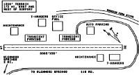
Maps & Diagrams
GWS Sectional
Flight Planning
at skyvector.com
at skyvector.com