Location
Latitude: |
41-11-45.5500N (41.195986) |
Longitude: |
096-06-44.1530W (-96.112265) |
Elevation: |
1050.7 feet MSL (320 m MSL) |
Magnetic Variation: |
2.2 E (as of April 2024 from WMM2020 model) |
Time Zone: |
UTC -6.0 (Standard Time) UTC -5.0 (Daylight Savings Time) |
From City: |
07 N.M. SW of Omaha, Nebraska |
Found On: |
Omaha Chart |
FAA Region: |
ACE |
Contacts
Manager: |
Publicly owned: |
| DAVID ROTH 4501 ABBOTT DRIVE, SUITE 2300 OMAHA, NE 68110-2689 402-661-8000 |
OMAHA AIRPORT AUTHORITY 4501 ABBOTT DRIVE, SUITE 2300 OMAHA, NE 68110-2689 402-661-8000 |
Operations
Airport Status: |
Operational |
Facility Use: |
Public |
Type: |
Airport |
Control tower: |
No |
Attendance (Months/Days/Hours): |
Months/Days/Hours ALL/ALL/0630-2100 |
Boundary ARTCC: |
ZMP (Minneapolis) |
Responsible ARTCC: |
ZMP (Minneapolis) |
Lighting Schedule: |
SEE RMK |
Segmented Circle Indicator: |
No |
Traffic Pattern Altitude (MSL): |
2051 feet (625 m) |
NOTAMs Facility: |
MLE |
NOTAM-D Service: |
Yes |
International Airport of Entry: |
No |
Customs Landing Rights: |
No |
Military Landing Rights: |
Yes |
Civil/Military Joint Use: |
No |
Based Aircraft
| Single Engine: | 115 |
| Multi Engine: | 9 |
| Gliders: | 1 |
Annual Operations (as of 09/20/2021)
| Total Operations: | 24000 | |
| Air Taxi: | 1375 | 5.7% |
| GA Local: | 8400 | 35.0% |
| GA Itinerant: | 14150 | 59.0% |
| Military Aircraft: | 75 | 0.3% |
Communications
| CTAF: | 123.000 |
| Unicom: | 123.000 |
| Approach: | OMAHA 120.1 120.1 120.1 |
| Departure: | OMAHA 120.1 120.1 120.1 |
| AWOS-3: | 118.25 (402-895-6778) |
- A CONTINUOUS TRANSCRIBED BROADCAST FOR MILLARD ARPT WHICH INCLUDES TEMPERATURE / DEWPOINT / WIND SPEED AND DIRECTION; AND ALTIMETER SETTING IS AVAILABLE ON FREQ 118.25 OR BY TELEPHONE (402) 895-6778.
Fixed Based Operators (FBOs) & Fuel
(Click on a business for detail)
Please help us keep this information up to date. This is a FREE SERVICE just like everything else on Airport Guide! If you see that a business needs to be added, modified, or deleted please fill out our Update Form.
To add, modify, or delete a business click here.
Please help us keep this information up to date. This is a FREE SERVICE just like everything else on Airport Guide! If you see that a business needs to be added, modified, or deleted please fill out our Update Form.
Area Code: 402 |
| Business Name | Frequency | Phone | Fuel Grade |
|---|---|---|---|
| Hangar One
Update FBO info |
Unicom 123.0 | 895-4974 | 100LL, Jet A |
Flight Service Stations
| Primary | Alternate | |
| FSS on Field: | N | |
| FSS Name (ID): | Columbus(OLU) | |
| Frequency: | ||
| Toll Free Phone: | 1-800-WX-BRIEF |
Instrument Procedures / Charts
FAA Terminal Procedures valid from 0901Z 03/21/24 to 0901Z 04/18/24.
There are various types of charts available for an airport. They are listed in the Page Type column. Here is a legend for those types:
APD - Airport Diagram
DP - Departure Procedure Charts
HOT - Hot Spots
IAP - Instrument Approach Procedure Charts
MIN - Minimums
STAR - Standard Terminal Arrival Charts
| Page Type | Page Name | Volume | Action Since Last Cycle |
|---|---|---|---|
| IAP | RNAV (GPS) RWY 12 | NC-2 | Changed |
| IAP | RNAV (GPS) RWY 30 | NC-2 | Changed |
| MIN | ALTERNATE MINIMUMS | NC-2 | |
| MIN | TAKEOFF MINIMUMS | NC-2 |
Terminal Procedures are only available for airports in several countries with more being added all the time. If you are looking for a specific country's charts, please send an email to support(at)airportguide.com stating the country name. This will be used to prioritize the implementation.
Navigation Aids (Navaids) near MIQ
| Dist (NM) | ID | Morse Code | Name | Type | Freq | True Hdg | Mag Hdg |
|---|---|---|---|---|---|---|---|
| 0.1 | MLE | _ _ . _ . . . | Millard | NDB | 371 | 230 | 228 |
| 10.7 | OFF | _ _ _ . . _ . . . _ . | Offutt | TACAN | 111.70 | 116 | 114 |
| 11.8 | OMA | _ _ _ _ _ . _ | Omaha | VOT | 109.00 | 59 | 57 |
| 12.4 | OM | _ _ _ _ _ | Gerfi | NDB | 320 | 34 | 32 |
| 13.4 | EN | . _ . | Rikky | NDB | 426 | 83 | 81 |
| 17.0 | OVR | _ _ _ . . . _ . _ . | Omaha | VORTAC | 116.30 | 95 | 93 |
| 17.6 | PMV | . _ _ . _ _ . . . _ | Plattsmouth | NDB | 329 | 149 | 147 |
| 22.1 | AHQ | . _ . . . . _ _ . _ | Wahoo | NDB | 400 | 276 | 274 |
| 32.8 | LNK | . _ . . _ . _ . _ | Lincoln | VORTAC | 116.10 | 240 | 238 |
| 33.8 | SCB | . . . _ . _ . _ . . . | Scribner | VOR-DME | 111.00 | 316 | 314 |
| 33.9 | TQE | _ _ _ . _ . | Tekamah | VOR | 108.40 | 354 | 352 |
| 37.2 | AFK | . _ . . _ . _ . _ | Nebraska City | NDB | 347 | 162 | 160 |
| 39.9 | LN | . _ . . _ . | Potts | NDB | 385 | 227 | 225 |
| 40.2 | RDK | . _ . _ . . _ . _ | Red Oak | NDB | 230 | 105 | 103 |
| 41.6 | SDA | . . . _ . . . _ | Shenandoah | NDB | 411 | 129 | 127 |
| 41.6 | HNR | . . . . _ . . _ . | Harlan | NDB | 272 | 56 | 54 |
| 49.5 | SWT | . . . . _ _ _ | Seward | NDB | 269 | 246 | 243 |
| 49.6 | AIO | . _ . . _ _ _ | Atlantic | NDB | 365 | 75 | 73 |
| 56.7 | ICL | . . _ . _ . . _ . . | Clarinda | NDB | 353 | 119 | 117 |
| 57.4 | OLU | _ _ _ . _ . . . . _ | Columbus | VOR-DME | 111.80 | 285 | 282 |
Nearby Airports with Fuel
Notices to Airmen (NOTAMS)
Remarks
| A110-1 | MIL JETS OVERFLYING AT 3000 FT MSL. |
| A110-2 | AFTER TKOF ON RY 30 ALTER HDG 20 DEGS TO THE R TO AVOID NOISE SENSITIVE AREA. |
| A110-3 | NORMAL CALM & CROSS WIND TKOFS & LNDGS OF RY 12; NO INTXN TKOFS. |
| A110-4 | RADIO CONTROLLED ACFT OCCASIONAL OPERATION 1.7 MI SW OF ARPT. |
| A110-5 | VFR ACFT REQUESTING FLIGHT FLWG & IFR ACFT SHOULD CONTACT OMAHA APCH ON FREQ 125.4 PRIOR TO TAKING THE RY FOR CLNC/TRAFFIC ADVISORIES/GEN INFO. |
| A110-6 | DEER ON & INVOF ARPT. |
| A110-7 | SELF-SVC FUEL AVBL 24 HRS WITH CREDIT CARD. |
| A17 | FOR SVC AFT 2100 CALL 402-953-9905 OR 402-690-3099. |
| A57-12 | APCH RATIO 36:1 FROM DSPLCD THR |
| A81-APT | ACTVT MIRL RY 12/30 & REIL RY 12 - CTAF. |
Runways
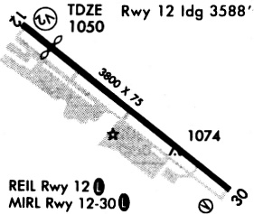
Runway Summary
| Runways: | 12/30 |
| Longest Runway: | 12/30 is 3801 ft (1159 m) long |
| Runways with an Instrument Approach: |
MIQ Airport Runway Details
| Runway 12/30 | 3801 ft x 75 ft (1159 m x 23 m) | |
| Runway Length Source: | NGS as of 08/22/1997 | |
| Surface: | Asphalt - Good condition - No special surface treatment | |
| Runway Edge Lights: | Medium Intensity | |
Runway Weight Bearing Capacity (in thousands of pounds) |
||
| Single Wheel Landing Gear: | 25.0 | |
| Dual Wheel Landing Gear: | 28.0 | |
Runway 12 |
Runway 30 |
|
Elevation: |
1050.6 | 1046.0 |
Latitude: |
41-11-57.3080N | 41-11-33.7930N |
Longitude: |
096-07-03.5320W | 096-06-24.7740W |
|
Runway True Alignment: |
129 | 309 |
Glide Path Angle: |
3.1 degrees | 3.1 degrees |
Traffic Pattern: |
Left | Left |
Runway Markings Type: |
Nonprecision Instrument | Nonprecision Instrument |
Runway Markings Condition: |
Good | Good |
Object at End: |
ROAD | TREE |
Object Height: |
17 | 57 |
Distance from End: |
410 | 824 |
Object Centerline Offset: |
285 ft. right of centerline | 269 ft. right of centerline |
Visual Glide Slope Indicators: |
2-Light PAPI On Left Side Of Runway | 2-Light PAPI On Left Side Of Runway |
REIL: |
Yes | |
Threshold Crossing Height: |
39 | 39 |
Threshold Elevation: |
1050.7 | |
Displaced Threshold: |
212 | |
Threshold Latitude: |
41-11-55.9974N | |
Threshold Longitude: |
096-07-01.3724W | |
Declared Distances |
||
Take Off Run Avbl. (TORA): |
3801 | 3801 |
Take Off Distance Avbl. (TODA): |
3801 | 3801 |
Actual Stop Dist. Avbl. (ASDA): |
3801 | 3588 |
Landing Dist. Avbl. (LDA): |
3588 | 3801 |
Services
Airframe Repair: |
Minor |
Powerplant Repair: |
Minor |
Bottled Oxygen: |
None |
Bulk Oxygen: |
None |
Fuel Available: |
100LL |
Landing Fees: |
No |
Parking: |
Tiedowns available |
Maps & Diagrams
MIQ Sectional
Flight Planning
at skyvector.com
at skyvector.com