Location
Latitude: |
62-27-09.5360N (62.452649) |
Longitude: |
157-59-20.6520W (-157.98907) |
Elevation: |
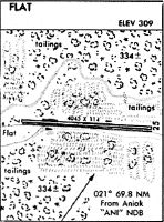
309.0 feet MSL (94 m MSL) |
Magnetic Variation: |
11.5 E (as of May 2024 from WMM2020 model) |
Time Zone: |
UTC -9.0 (Standard Time) UTC -8.0 (Daylight Savings Time) |
From City: |
00 N.M. E of Flat, Alaska |
Found On: |
Mc Grath Chart |
FAA Region: |
AAL |
Contacts
Manager: |
Publicly owned: |
| STEFFEN STRICK PO BOX 21 MCGRATH, AK 99627 907-524-3241 |
ALASKA DOT&PF CENTRAL REGION PO BOX 196900 ANCHORAGE, AK 99519-6900 (907) 269-0749 |
Operations
Airport Status: |
Operational |
Facility Use: |
Public |
Type: |
Airport |
Activation Date: |
08/1947 |
Control tower: |
No |
Attendance (Months/Days/Hours): |
Months/Days/Hours Unattended |
Boundary ARTCC: |
ZAN (Anchorage) |
Responsible ARTCC: |
ZAN (Anchorage) |
Segmented Circle Indicator: |
No |
Traffic Pattern Altitude (MSL): |
1309 feet (399 m) |
NOTAMs Facility: |
ENA |
NOTAM-D Service: |
Yes |
International Airport of Entry: |
No |
Customs Landing Rights: |
No |
Military Landing Rights: |
Yes |
Civil/Military Joint Use: |
No |
Based Aircraft
Annual Operations (as of 12/31/2022)
| Total Operations: | 100 | |
| Air Taxi: | 100 | 100.0% |
Communications
| CTAF: | 122.900 |
Fixed Based Operators (FBOs) & Fuel
(Click on a business for detail)
Please help us keep this information up to date. This is a FREE SERVICE just like everything else on Airport Guide! If you see that a business needs to be added, modified, or deleted please fill out our Update Form.
To add, modify, or delete a business click here.
Please help us keep this information up to date. This is a FREE SERVICE just like everything else on Airport Guide! If you see that a business needs to be added, modified, or deleted please fill out our Update Form.
Area Code: 907 |
| Business Name | Frequency | Phone | Fuel Grade |
|---|
Flight Service Stations
| Primary | Alternate | |
| FSS on Field: | N | |
| FSS Name (ID): | Kenai(ENA) | |
| Frequency: | ||
| Toll Free Phone: | 1-866-864-1737 |
Instrument Procedures / Charts
Terminal Procedures are only available for airports in several countries with more being added all the time. If you are looking for a specific country's charts, please send an email to support(at)airportguide.com stating the country name. This will be used to prioritize the implementation.
Navigation Aids (Navaids) near FLT
| Dist (NM) | ID | Morse Code | Name | Type | Freq | True Hdg | Mag Hdg |
|---|---|---|---|---|---|---|---|
| 61.8 | ANV | . _ _ . . . . _ | Anvik | NDB | 365 | 281 | 270 |
| 68.8 | ANI | . _ _ . . . | Aniak | NDB | 359 | 221 | 210 |
| 71.9 | MCG | _ _ _ . _ . _ _ . | Mc Grath | VORTAC | 115.50 | 64 | 52 |
| 73.2 | VTR | . . . _ _ . _ . | Takotna River | NDB | 350 | 65 | 53 |
Nearby Airports with Fuel
| Dist (NM) | Name (Airport IDs) | True Hdg | Mag Hdg | Fuel Grade |
|---|---|---|---|---|
| 35.1 | Crooked Creek Airport (CKD CJX) |
186 | 175 | MOGAS |
| 68.2 | Aniak Airport (ANI PANI ANI) |
220 | 209 | 100LL, Jet A |
| 72.1 | Mc Grath Airport (MCG PAMC MCG) |
64 | 52 | 100LL, Jet A-1+ |
Notices to Airmen (NOTAMS)
Remarks
| A110-1 | RY CONDITION NOT MONITORED; RCMD VISUAL INSPECTION PRIOR TO USING. |
| A110-3 | SMALL TREES, GRASS AND SHRUBS ALONG RY. |
| A110-4 | NO MAINTENANCE ON RY. |
| A33-08/26 | SFC COVERED WITH 12 TO 30 IN GRASS & BRUSH. |
| A33-08/26 1 | RY SOFT WHEN WET 600 FT FM RY 26. RY 26 LAST 150 FT UNUSABLE BRUSH AND GRASS. |
| A42-08 | RY 08 MKD WITH ORANGE 3 FT CONES AND THLD PANELS. CONES AND THLD PANELS OVERGROWN AND MOSTLY INVISIBLE. |
| A42-26 | RY 26 MKD WITH ORANGE 3 FT CONES AND THLD PANELS. CONES AND THLD PANELS MOSTLY OVERGROWN. |
| A51-26 | DSPLD THLD MKD WITH WHITE 55 GAL DRUMS. |
| E111 | ESTABD PRIOR TO 1959. |
Runways
Runway Summary
| Runways: | 08/26 |
| Longest Runway: | 08/26 is 4045 ft (1233 m) long |
| Runways with an Instrument Approach: |
FLT Airport Runway Details
| Runway 08/26 | 4045 ft x 90 ft (1233 m x 27 m) | |
| Surface: | Turf/Gravel - Poor condition - No special surface treatment | |
Runway 08 |
Runway 26 |
|
Glide Path Angle: |
0.0 degrees | 0.0 degrees |
Traffic Pattern: |
Left | Left |
Runway Markings Type: |
Nonstandard (other than numbers only) | Nonstandard (other than numbers only) |
Runway Markings Condition: |
Poor | Poor |
Object at End: |
TREES | TREES |
Object Height: |
38 | 18 |
Distance from End: |
0 | 0 |
Object Centerline Offset: |
120 ft. left and right of centerline | 85 ft. left of centerline |
Displaced Threshold: |
1445 |
Services
Airframe Repair: |
Minor |
Powerplant Repair: |
Minor |
Fuel Available: |
100LL, Jet A-1+ |
Landing Fees: |
No |
Parking: |
Hangars and tiedowns available |
Maps & Diagrams
FLT Sectional
Flight Planning
at skyvector.com
at skyvector.com