Location
Latitude: |
37-35-00.0000N (37.583333) |
Longitude: |
109-28-59.8000W (-109.483278) |
Elevation: |
5867.8 feet MSL (1789 m MSL) |
Magnetic Variation: |
9.5 E (as of April 2024 from WMM2020 model) |
Time Zone: |
UTC -7.0 (Standard Time) UTC -6.0 (Daylight Savings Time) |
From City: |
03 N.M. S of Blanding, Utah |
Found On: |
Denver Chart |
FAA Region: |
ANM |
Contacts
Manager: |
Publicly owned: |
| BRET HOSLER 50 WEST 100 SOUTH BLANDING, UT 84511 435-459-3275 |
BLANDING CITY 50 WEST 100 SOUTH BLANDING, UT 84511 435-678-2791 |
Operations
Airport Status: |
Operational |
Facility Use: |
Public |
Type: |
Airport |
Control tower: |
No |
Attendance (Months/Days/Hours): |
Months/Days/Hours ALL/ALL/ALL |
Boundary ARTCC: |
ZDV (Denver) |
Responsible ARTCC: |
ZDV (Denver) |
Lighting Schedule: |
SEE RMK |
Segmented Circle Indicator: |
Yes |
Traffic Pattern Altitude (MSL): |
6868 feet (2093 m) |
NOTAMs Facility: |
CDC |
NOTAM-D Service: |
Yes |
International Airport of Entry: |
No |
Customs Landing Rights: |
No |
Military Landing Rights: |
Yes |
Civil/Military Joint Use: |
No |
Based Aircraft
| Single Engine: | 18 |
| Multi Engine: | 1 |
| Gliders: | 1 |
Annual Operations (as of 10/01/2023)
| Total Operations: | 2730 | |
| Air Taxi: | 100 | 3.7% |
| GA Local: | 780 | 28.6% |
| GA Itinerant: | 1850 | 67.8% |
Communications
| CTAF: | 122.800 |
| Unicom: | 122.800 |
| AWOS-3PT: | 127.75 (435-678-2636) |
- APCH/DEP CTL SVC PRVDD BY DENVER ARTCC (ZDV) ON FREQS 127.55 (ABAJO PEAK/A/ RCAG) AND 354.05 (ABAJO PEAK RCAG).
Fixed Based Operators (FBOs) & Fuel
(Click on a business for detail)
Please help us keep this information up to date. This is a FREE SERVICE just like everything else on Airport Guide! If you see that a business needs to be added, modified, or deleted please fill out our Update Form.
To add, modify, or delete a business click here.
Please help us keep this information up to date. This is a FREE SERVICE just like everything else on Airport Guide! If you see that a business needs to be added, modified, or deleted please fill out our Update Form.
Area Code: 435 |
| Business Name | Frequency | Phone | Fuel Grade |
|---|---|---|---|
| Eagle Air Med
Update FBO info |
Unicom 122.8 | 678-3222 | |
| Redd's Aviation Maintenance
Update FBO info |
678-2449, in emergency call 678-2977 | ||
| Scenic Aviation
Update FBO info |
Unicom 122.8 | 678-3222 | 100LL, Jet A |
Flight Service Stations
| Primary | Alternate | |
| FSS on Field: | N | |
| FSS Name (ID): | Cedar City(CDC) | |
| Frequency: | ||
| Toll Free Phone: | 1-800-WX-BRIEF |
Instrument Procedures / Charts
FAA Terminal Procedures valid from 0901Z 03/21/24 to 0901Z 04/18/24.
There are various types of charts available for an airport. They are listed in the Page Type column. Here is a legend for those types:
APD - Airport Diagram
DP - Departure Procedure Charts
HOT - Hot Spots
IAP - Instrument Approach Procedure Charts
MIN - Minimums
STAR - Standard Terminal Arrival Charts
| Page Type | Page Name | Volume | Action Since Last Cycle |
|---|---|---|---|
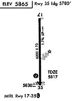
| IAP | RNAV (GPS) RWY 35 | SW-4 | |
| MIN | ALTERNATE MINIMUMS | SW-4 | |
| MIN | TAKEOFF MINIMUMS | SW-4 |
Terminal Procedures are only available for airports in several countries with more being added all the time. If you are looking for a specific country's charts, please send an email to support(at)airportguide.com stating the country name. This will be used to prioritize the implementation.
Navigation Aids (Navaids) near BDG
| Dist (NM) | ID | Morse Code | Name | Type | Freq | True Hdg | Mag Hdg |
|---|---|---|---|---|---|---|---|
| 29.5 | DVC | _ . . . . . _ _ . _ . | Dove Creek | VORTAC | 114.60 | 62 | 53 |
| 45.4 | CEZ | _ . _ . . _ _ . . | Cortez | VOR-DME | 114.35 | 104 | 95 |
| 64.2 | ETL | . _ . _ . . | Cones | VOR-DME | 110.20 | 64 | 55 |
| 71.5 | OAB | _ _ _ . _ _ . . . | Moab | VOR-DME | 109.80 | 349 | 339 |
| 76.2 | HVE | . . . . . . . _ . | Hanksville | VORTAC | 115.90 | 311 | 301 |
| 83.0 | RSK | . _ . . . . _ . _ | Rattlesnake | VORTAC | 115.30 | 126 | 117 |
| 86.6 | DRO | _ . . . _ . _ _ _ | Durango | VOR-DME | 116.55 | 106 | 97 |
| 93.1 | MTJ | _ _ _ . _ _ _ | Montrose | VOR-DME | 117.10 | 53 | 44 |
| 94.4 | JNC | . _ _ _ _ . _ . _ . | Grand Junction | VOR-DME | 112.40 | 19 | 10 |
Nearby Airports with Fuel
| Dist (NM) | Name (Airport IDs) | True Hdg | Mag Hdg | Fuel Grade |
|---|---|---|---|---|
| 22.0 | Monticello Airport (U64) |
17 | 8 | 100LL, Jet A |
| 44.1 | Cortez Municipal Airport (CEZ KCEZ CEZ) |
112 | 103 | 100LL, Jet A |
| 52.2 | Cal Black Meml Airport (U96) |
260 | 250 | 100LL, Jet A |
| 58.7 | Hopkins Field Airport (KAIB AIB) |
47 | 38 | 100LL, Jet A |
| 71.6 | Canyonlands Regional Airport (CNY KCNY CNY) |
349 | 339 | 100LL, Jet A |
| 77.9 | Telluride Regional Airport (TEX KTEX TEX) |
72 | 63 | 100LL, Jet A |
| 78.4 | Four Corners Regional Airport (FMN KFMN FMN) |
129 | 120 | 100LL, Jet A, Jet A-1+ |
| 80.3 | Animas Air Park Airport (AMK 00C) |
106 | 97 | 100LL, Jet A |
| 86.4 | Durango-La Plata County Airport (DRO KDRO DRO) |
106 | 97 | 100LL, Jet A |
| 89.8 | Green River Municipal Airport (RVR U34) |
337 | 327 | 100LL |
| 93.4 | Montrose Regional Airport (MTJ KMTJ MTJ) |
52 | 43 | 100LL, Jet A+ |
| 98.5 | Blake Field Airport (KAJZ AJZ) |
42 | 33 | 100LL, Jet A |
Notices to Airmen (NOTAMS)
Remarks
| A110-2 | WILDLIFE ON AND INVOF ARPT. |
| A110-3 | FOR CD CTC DENVER ARTCC AT 303-651-4257. |
| A14 | DIR COMM. DEV/ARPT MGR. 435-678-2791. |
| A16 | FBO/ARPT ATTENDANT. |
| A42-17 | RWY MKGS FADED. |
| A42-35 | RWY MKGS FADED. |
| A70-FUEL-10 | 0LL 24 HR FULL & SELF-SVC. CALL-IN & RAMP SVC FEE WAIVED WITH MIN FUEL PURCHASE. |
| A81-APT | ACTVT MIRL RWY 17/35, REIL - CTAF. PAPI RWY 17 & 35 OPER CONSLY. |
Runways
Runway Summary
| Runways: | 17/35 |
| Longest Runway: | 17/35 is 5781 ft (1762 m) long |
| Runways with an Instrument Approach: |
BDG Airport Runway Details
| Runway 17/35 | 5781 ft x 75 ft (1762 m x 23 m) | |
| Runway Length Source: | 3RD PARTY SURVEY as of 08/25/2009 | |
| Surface: | Asphalt - Good condition - No special surface treatment | |
| Runway Edge Lights: | Medium Intensity | |
Runway Weight Bearing Capacity (in thousands of pounds) |
||
| Single Wheel Landing Gear: | 27.0 | |
Runway 17 |
Runway 35 |
|
Elevation: |
5867.8 | 5774.5 |
Latitude: |
37-35-28.5858N | 37-34-31.4546N |
Longitude: |
109-28-59.8066W | 109-28-59.8618W |
|
Runway True Alignment: |
180 | 000 |
Glide Path Angle: |
3.0 degrees | 3.0 degrees |
Traffic Pattern: |
Left | Left |
Runway Markings Type: |
Basic | Nonprecision Instrument |
Runway Markings Condition: |
Poor | Poor |
Object at End: |
ROAD | |
Object Height: |
15 | |
Distance from End: |
620 | |
Object Centerline Offset: |
0 ft. left and right of centerline | |
Visual Glide Slope Indicators: |
4-Light PAPI On Left Side Of Runway | 4-Light PAPI On Left Side Of Runway |
REIL: |
Yes | Yes |
Threshold Crossing Height: |
40 | 40 |
Services
Airframe Repair: |
Major |
Powerplant Repair: |
Minor |
Bottled Oxygen: |
High Pressure |
Bulk Oxygen: |
None |
Fuel Available: |
100LL, Jet A |
Landing Fees: |
No |
Parking: |
Hangars and tiedowns available |
Maps & Diagrams
BDG Sectional
Flight Planning
at skyvector.com
at skyvector.com