Location
Latitude: |
39-21-40.4090N (39.361225) |
Longitude: |
110-55-01.1300W (-110.916981) |
Elevation: |
5915.3 feet MSL (1803 m MSL) |
Magnetic Variation: |
10.3 E (as of April 2024 from WMM2020 model) |
Time Zone: |
UTC -7.0 (Standard Time) UTC -6.0 (Daylight Savings Time) |
From City: |
03 N.M. NE of Huntington, Utah |
Found On: |
Denver Chart |
FAA Region: |
ANM |
Contacts
Manager: |
Publicly owned: |
| JEFF GUYMON 75 E MAIN ST., PO BOX 907 CASTLE DALE, UT 84513 435-381-3589 |
EMERY COUNTY 75 EAST MAIN, P. O. BOX 907 CASTLE DALE, UT 84513 435-381-2119 |
Operations
Airport Status: |
Operational |
Facility Use: |
Public |
Type: |
Airport |
Activation Date: |
01/1948 |
Control tower: |
No |
Attendance (Months/Days/Hours): |
Months/Days/Hours UNATTENDED |
Boundary ARTCC: |
ZLC (Salt Lake City) |
Responsible ARTCC: |
ZLC (Salt Lake City) |
Lighting Schedule: |
SEE RMK |
Segmented Circle Indicator: |
Yes |
Traffic Pattern Altitude (MSL): |
6915 feet (2108 m) |
NOTAMs Facility: |
CDC |
NOTAM-D Service: |
Yes |
International Airport of Entry: |
No |
Customs Landing Rights: |
No |
Military Landing Rights: |
Yes |
Civil/Military Joint Use: |
No |
Based Aircraft
| Single Engine: | 8 |
| Ultralights: | 2 |
Annual Operations (as of 09/29/2023)
| Total Operations: | 1860 | |
| Air Taxi: | 10 | 0.5% |
| GA Local: | 371 | 19.9% |
| GA Itinerant: | 1479 | 79.5% |
Communications
| CTAF: | 122.800 |
| Unicom: | 122.800 |
- APCH/DEP CTL SVC PRVDD BY SALT LAKE ARTCC (ZLC) ON FREQS 133.9/370.85 (SUNNYSIDE RCAG).
Fixed Based Operators (FBOs) & Fuel
(Click on a business for detail)
Please help us keep this information up to date. This is a FREE SERVICE just like everything else on Airport Guide! If you see that a business needs to be added, modified, or deleted please fill out our Update Form.
To add, modify, or delete a business click here.
Please help us keep this information up to date. This is a FREE SERVICE just like everything else on Airport Guide! If you see that a business needs to be added, modified, or deleted please fill out our Update Form.
Area Code: 801 |
| Business Name | Frequency | Phone | Fuel Grade |
|---|---|---|---|
| K&A Airport Service & Kit Plane
Update FBO info |
Unicom 122.8 | 687-2159, after hours 435-687-2167 | 100LL, Jet A |
Flight Service Stations
| Primary | Alternate | |
| FSS on Field: | N | |
| FSS Name (ID): | Cedar City(CDC) | |
| Frequency: | ||
| Toll Free Phone: | 1-800-WX-BRIEF |
Instrument Procedures / Charts
FAA Terminal Procedures valid from 0901Z 03/21/24 to 0901Z 04/18/24.
There are various types of charts available for an airport. They are listed in the Page Type column. Here is a legend for those types:
APD - Airport Diagram
DP - Departure Procedure Charts
HOT - Hot Spots
IAP - Instrument Approach Procedure Charts
MIN - Minimums
STAR - Standard Terminal Arrival Charts
| Page Type | Page Name | Volume | Action Since Last Cycle |
|---|---|---|---|
| IAP | RNAV (GPS)-C | SW-4 | |
| IAP | VOR-B | SW-4 | |
| MIN | TAKEOFF MINIMUMS | SW-4 |
Terminal Procedures are only available for airports in several countries with more being added all the time. If you are looking for a specific country's charts, please send an email to support(at)airportguide.com stating the country name. This will be used to prioritize the implementation.
Navigation Aids (Navaids) near 69V
| Dist (NM) | ID | Morse Code | Name | Type | Freq | True Hdg | Mag Hdg |
|---|---|---|---|---|---|---|---|
| 16.4 | PUC | . _ _ . . . _ _ . _ . | Carbon | VOR-DME | 115.50 | 27 | 17 |
| 57.6 | HVE | . . . . . . . _ . | Hanksville | VORTAC | 115.90 | 169 | 159 |
| 59.7 | MTU | _ _ _ . . _ | Myton | VOR-DME | 112.70 | 37 | 27 |
| 63.2 | PVU | . _ _ . . . . _ . . _ | Provo | VOR-DME | 108.40 | 324 | 314 |
| 65.4 | OAB | _ _ _ . _ _ . . . | Moab | VOR-DME | 109.80 | 123 | 113 |
| 72.3 | FFU | . . _ . . . _ . . . _ | Fairfield | VORTAC | 116.60 | 319 | 308 |
| 73.8 | DTA | _ . . _ . _ | Delta | VORTAC | 116.10 | 267 | 256 |
| 89.6 | VEL | . . . _ . . _ . . | Vernal | VOR-DME | 108.20 | 46 | 36 |
| 97.2 | SLC | . . . . _ . . _ . _ . | Salt Lake City | VOT | 111.00 | 330 | 319 |
| 99.7 | TVY | _ . . . _ _ . _ _ | Tooele | NDB | 371 | 319 | 308 |
Nearby Airports with Fuel
Notices to Airmen (NOTAMS)
Remarks
| A110-1 | RY 08/26 NO LINE OF SIGHT BTN RY ENDS. |
| A110-2 | FOR CD CTC SALT LAKE ARTCC AT 801-320-2568. |
| A33-12/30 | SMALL AMOUNTS OF VEGETATION ON RUNWAY 12/30. |
| A33-18/36 | SMALL AMOUNTS OF VEGETATION ON RUNWAY 18/36. |
| A52-12 | MARKED PLINE 360' FROM END RWY. |
| A57-08 | APCH SLOPE 48:1 TO DTHR. |
| A57-18 | 15 FT DROP OFF AT RWY 18 END. |
| A57-36 | 15 FT DROP OFF AT RWY 36 END. |
| A58-26 | 15 FT TREES, 20 FT DSTC, 70 FT R. |
| A70-FUEL-10 | 0LL FUEL 24 HR SELF SERVE. |
| A81-APT | ACTVT MIRL RY 08/26 - CTAF. |
| E100 | LCL WX AVBL CTAF 122.8 , 3 CLICKS. |
| E111 | EXISTED PRIOR TO 1959. |
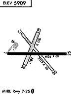
Runways
Runway Summary
| Runways: | 08/26 12/30 18/36 |
| Longest Runway: | 08/26 is 4048 ft (1234 m) long |
| Runways with an Instrument Approach: |
69V Airport Runway Details
| Runway 08/26 | 4048 ft x 75 ft (1234 m x 23 m) | |
| Runway Length Source: | STATE as of 10/20/2003 | |
| Surface: | Asphalt - Good condition - No special surface treatment | |
| Runway Edge Lights: | Medium Intensity | |
Runway Weight Bearing Capacity (in thousands of pounds) |
||
| Single Wheel Landing Gear: | 12.5 | |
Runway 08 |
Runway 26 |
|
Elevation: |
5903.0 | 5871.5 |
Latitude: |
39-21-39.7900N | 39-21-39.8600N |
Longitude: |
110-55-25.5900W | 110-54-34.0400W |
|
Runway True Alignment: |
090 | 270 |
Glide Path Angle: |
0.0 degrees | 0.0 degrees |
Traffic Pattern: |
Left | Left |
Runway Markings Type: |
Nonprecision Instrument | Nonprecision Instrument |
Runway Markings Condition: |
Fair | Fair |
Object at End: |
ROAD | TREES |
Object Height: |
10 | 15 |
Distance from End: |
270 | 210 |
Object Centerline Offset: |
269 ft. left of centerline | 154 ft. left of centerline |
Threshold Elevation: |
5902.6 | |
Displaced Threshold: |
214 | |
Threshold Latitude: |
39-21-39.7900N | |
Threshold Longitude: |
110-55-22.8700W |
| Runway 12/30 | 3640 ft x 70 ft (1109 m x 21 m) | |
| Runway Length Source: | STATE as of 05/12/2004 | |
| Surface: | Asphalt - Good condition - No special surface treatment | |
Runway Weight Bearing Capacity (in thousands of pounds) |
||
| Single Wheel Landing Gear: | 6.0 | |
Runway 12 |
Runway 30 |
|
Elevation: |
5915.0 | 5872.7 |
Latitude: |
39-21-54.4300N | 39-21-26.9800N |
Longitude: |
110-55-14.6000W | 110-54-44.5900W |
|
Runway True Alignment: |
140 | 320 |
Glide Path Angle: |
0.0 degrees | 0.0 degrees |
Traffic Pattern: |
Left | Left |
Object at End: |
FENCE | TREES |
Object Height: |
13 | 22 |
Distance from End: |
110 | 50 |
Object Centerline Offset: |
269 ft. left of centerline | 154 ft. left of centerline |
| Runway 18/36 | 2079 ft x 56 ft (634 m x 17 m) | |
| Runway Length Source: | STATE as of 05/12/2004 | |
| Surface: | Asphalt - Good condition - No special surface treatment | |
Runway 18 |
Runway 36 |
|
Elevation: |
5901.6 | 5888.1 |
Latitude: |
39-21-50.5100N | 39-21-31.5500N |
Longitude: |
110-55-01.2800W | 110-55-11.4800W |
|
Runway True Alignment: |
203 | 023 |
Glide Path Angle: |
0.0 degrees | 0.0 degrees |
Object Centerline Offset: |
269 ft. left of centerline | 154 ft. left of centerline |
Services
Airframe Repair: |
None |
Powerplant Repair: |
None |
Bottled Oxygen: |
None |
Bulk Oxygen: |
None |
Fuel Available: |
100LL |
Landing Fees: |
No |
Parking: |
Tiedowns available |
Maps & Diagrams
69V Sectional
Flight Planning
at skyvector.com
at skyvector.com