Location
Latitude: |
39-31-54.3000N (39.53175) |
Longitude: |
084-23-47.2000W (-84.396444) |
Elevation: |
650.6 feet MSL (198 m MSL) |
Magnetic Variation: |
6.2 W (as of April 2024 from WMM2020 model) |
Time Zone: |
UTC -5.0 (Standard Time) UTC -4.0 (Daylight Savings Time) |
From City: |
02 N.M. N of Middletown, Ohio |
Found On: |
Cincinnati Chart |
FAA Region: |
AGL |
Contacts
Manager: |
Publicly owned: |
| JO DIBLE 1 DONHAM PLZ MIDDLETOWN, OH 45042-1932 513-422-9750 |
CITY OF MIDDLETOWN 1 DONHAM PLZ MIDDLETOWN, OH 45042-1932 513-425-7845 |
Operations
Airport Status: |
Operational |
Facility Use: |
Public |
Type: |
Airport |
Activation Date: |
01/1946 |
Control tower: |
No |
Attendance (Months/Days/Hours): |
Months/Days/Hours ALL/ALL/0700-1900 |
Boundary ARTCC: |
ZID (Indianapolis) |
Responsible ARTCC: |
ZID (Indianapolis) |
Lighting Schedule: |
SEE RMK |
Segmented Circle Indicator: |
No |
Traffic Pattern Altitude (MSL): |
1651 feet (503 m) |
NOTAMs Facility: |
DAY |
NOTAM-D Service: |
Yes |
International Airport of Entry: |
No |
Customs Landing Rights: |
No |
Military Landing Rights: |
Yes |
Civil/Military Joint Use: |
No |
Based Aircraft
| Single Engine: | 77 |
| Multi Engine: | 2 |
| GA Helicopters: | 2 |
Annual Operations (as of 10/12/2022)
| Total Operations: | 40050 | |
| Air Taxi: | 3600 | 9.0% |
| GA Local: | 17800 | 44.4% |
| GA Itinerant: | 18600 | 46.4% |
| Military Aircraft: | 50 | 0.1% |
Communications
| CTAF: | 123.000 |
| Unicom: | 123.000 |
| Approach: | COLUMBUS |
| Departure: | COLUMBUS |
| AWOS-3PT: | 120.025 (513-422-3505) |
Fixed Based Operators (FBOs) & Fuel
(Click on a business for detail)
Please help us keep this information up to date. This is a FREE SERVICE just like everything else on Airport Guide! If you see that a business needs to be added, modified, or deleted please fill out our Update Form.
To add, modify, or delete a business click here.
Please help us keep this information up to date. This is a FREE SERVICE just like everything else on Airport Guide! If you see that a business needs to be added, modified, or deleted please fill out our Update Form.
Area Code: 513 |
| Business Name | Frequency | Phone | Fuel Grade |
|---|---|---|---|
| Miami Valley Aviation
Update FBO info |
Unicom 123.0 | 423-5757 | 100LL, Jet A |
Flight Service Stations
| Primary | Alternate | |
| FSS on Field: | N | |
| FSS Name (ID): | Dayton(DAY) | |
| Frequency: | ||
| Toll Free Phone: | 1-800-WX-BRIEF |
Instrument Procedures / Charts
FAA Terminal Procedures valid from 0901Z 03/21/24 to 0901Z 04/18/24.
There are various types of charts available for an airport. They are listed in the Page Type column. Here is a legend for those types:
APD - Airport Diagram
DP - Departure Procedure Charts
HOT - Hot Spots
IAP - Instrument Approach Procedure Charts
MIN - Minimums
STAR - Standard Terminal Arrival Charts
| Page Type | Page Name | Volume | Action Since Last Cycle |
|---|---|---|---|
| IAP | LOC RWY 23 | EC-2 | |
| IAP | RNAV (GPS) RWY 05 | EC-2 | |
| IAP | RNAV (GPS) RWY 23 | EC-2 | |
| MIN | ALTERNATE MINIMUMS | EC-2 | |
| MIN | TAKEOFF MINIMUMS | EC-2 | |
| STAR | DANEI THREE | EC-2 |
Terminal Procedures are only available for airports in several countries with more being added all the time. If you are looking for a specific country's charts, please send an email to support(at)airportguide.com stating the country name. This will be used to prioritize the implementation.
Navigation Aids (Navaids) near MWO
| Dist (NM) | ID | Morse Code | Name | Type | Freq | True Hdg | Mag Hdg |
|---|---|---|---|---|---|---|---|
| 3.1 | HKF | . . . . _ . _ . . _ . | Hook Field | NDB | 239 | 230 | 236 |
| 4.4 | MW | _ _ . _ _ | Onida | NDB | 223 | 50 | 56 |
| 12.5 | HAO | . . . . . _ _ _ _ | Hamilton | NDB | 260 | 220 | 226 |
| 17.8 | OXD | _ _ _ _ . . _ _ . . | Oxford | NDB | 282 | 265 | 271 |
| 18.6 | MDE | _ _ _ . . . | Madeira | NDB | 379 | 174 | 180 |
| 19.1 | AT | . _ _ | Bruny | NDB | 315 | 8 | 14 |
| 22.5 | LUK | . _ . . . . _ _ . _ | Cincinnati | NDB | 335 | 173 | 179 |
| 23.3 | FFO | . . _ . . . _ . _ _ _ | Patterson | TACAN | 109.20 | 42 | 48 |
| 23.5 | DAY | _ . . . _ _ . _ _ | Dayton J M Cox-Day | VOT | 111.00 | 20 | 26 |
| 24.4 | RID | . _ . . . _ . . | Richmond | DME | 110.6 | 303 | 309 |
| 25.5 | LUK | . _ . . . . _ _ . _ | Cincinnati Muni/Lunken | VOT | 108.40 | 182 | 188 |
| 26.4 | HW | . . . . . _ _ | Cubla | NDB | 299 | 113 | 119 |
| 28.2 | MXQ | _ _ _ . . _ _ _ . _ | Midwest | VOR-DME | 112.90 | 102 | 108 |
| 28.6 | PWF | . _ _ . . _ _ . . _ . | Sportys | NDB | 245 | 162 | 168 |
| 29.1 | DQN | _ . . _ _ . _ _ . | Dayton | VOR-DME | 114.50 | 359 | 365 |
| 30.6 | IL | . . . _ . . | Airbo | NDB | 407 | 94 | 100 |
| 31.3 | SGH | . . . _ _ . . . . . | Springfield | DME | 113.2 | 54 | 60 |
| 31.6 | XSF | _ . . _ . . . . . _ . | Springfield | TACAN | 133.80 | 54 | 60 |
| 34.0 | UR | . . _ . _ . | Burln | NDB | 321 | 211 | 217 |
| 34.1 | CVG | _ . _ . . . . _ _ _ . | Cincinnati | VORTAC | 117.30 | 204 | 210 |
Nearby Airports with Fuel
Notices to Airmen (NOTAMS)
Remarks
| A110-1 | FOR CD CTC COLUMBUS APCH AT 614-338-8537. |
| A110-3 | EXTSV PAJA. |
| A110-4 | DEER, BIRDS, & OTR WILDLIFE ON & INVOF ARPT. |
| A110-5 | ULTRALIGHTS ENTER/EXIT RWY 08 TFC PAT FM/TO THE NORTH AT LWR THAN RGLR TPA. ULTRALIGHTS DO NOT FLY SOUTH OF RWY 26. |
| A14 | INFO@FLYMWO.COM. |
| A16 | CELL 513-267-0646. |
| A42-08 | WHITE CONES. |
| A42-26 | WHITE CONES. |
| A57-08 | OBSTN CLNC SLP 18:1 TO DTHR. |
| A57-23 | OBSTN CLNC SLP 33:1 TO DTHR. |
| A75 | PRIOR CDN RQRD FOR TSNT HNGR. |
| A81-APT | ACTVT REIL RWY 05 & 23; MIRL RWY 05/23 - CTAF. PAPI RWY 05 & 23 OPR CONSLY. |
Runways
Runway Summary
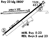
| Runways: | 05/23 08/26 |
| Longest Runway: | 05/23 is 6100 ft (1859 m) long |
| Runways with an Instrument Approach: | 23 |
MWO Airport Runway Details
| Runway 05/23 | 6100 ft x 100 ft (1859 m x 30 m) | |
| Surface: | Asphalt - Good condition - No special surface treatment | |
| Runway Edge Lights: | Medium Intensity | |
Runway Weight Bearing Capacity (in thousands of pounds) |
||
| Single Wheel Landing Gear: | 66.0 | |
| Dual Wheel Landing Gear: | 78.0 | |
| Dual Tandem Wheel Landing Gear: | 140.0 | |
Runway 05 |
Runway 23 |
|
Elevation: |
641.8 | 650.3 |
Latitude: |
39-31-32.0683N | 39-32-11.2686N |
Longitude: |
084-24-12.6170W | 084-23-13.4668W |
|
Runway True Alignment: |
049 | 229 |
ILS Type: |
LOCALIZER | |
Glide Path Angle: |
3.0 degrees | 3.0 degrees |
Traffic Pattern: |
Left | Right |
Runway Markings Type: |
Nonprecision Instrument | Nonprecision Instrument |
Runway Markings Condition: |
Good | Good |
Object at End: |
TREES | TREE |
Object Height: |
30 | 35 |
Distance from End: |
785 | 885 |
Object Centerline Offset: |
285 ft. left of centerline | 300 ft. left of centerline |
Visual Glide Slope Indicators: |
4-Light PAPI On Right Side Of Runway | 4-Light PAPI On Right Side Of Runway |
REIL: |
Yes | Yes |
Touchdown Lights: |
No | No |
Centerline Lights: |
No | No |
Threshold Crossing Height: |
22 | 26 |
Threshold Elevation: |
650.3 | |
Displaced Threshold: |
299 | |
Threshold Latitude: |
39-32-09.3453N | |
Threshold Longitude: |
084-23-16.3692W |
| Runway 08/26 | 3026 ft x 160 ft (922 m x 49 m) | |
| Runway Length Source: | 3RD PARTY SURVEY as of 10/12/2017 | |
| Surface: | Asphalt - Good condition - No special surface treatment | |
Runway 08 |
Runway 26 |
|
Elevation: |
643.0 | 644.4 |
Latitude: |
39-31-58.1885N | 39-32-00.7165N |
Longitude: |
084-24-14.8404W | 084-23-36.3627W |
|
Runway True Alignment: |
085 | 265 |
Glide Path Angle: |
0.0 degrees | 0.0 degrees |
Traffic Pattern: |
Left | Right |
Runway Markings Condition: |
Fair | Fair |
Object at End: |
TREES | |
Object Height: |
95 | |
Distance from End: |
775 | |
Object Centerline Offset: |
285 ft. left of centerline | 300 ft. left of centerline |
REIL: |
No | No |
Touchdown Lights: |
No | No |
Centerline Lights: |
No | No |
Threshold Elevation: |
643.1 | |
Displaced Threshold: |
951 | |
Threshold Latitude: |
39-31-58.9837N | |
Threshold Longitude: |
084-24-02.7462W |
Services
Airframe Repair: |
Minor |
Powerplant Repair: |
Minor |
Bottled Oxygen: |
None |
Bulk Oxygen: |
None |
Fuel Available: |
100LL, Jet A-1+ |
Landing Fees: |
No |
Parking: |
Hangars and tiedowns available |
Maps & Diagrams
MWO Sectional
Flight Planning
at skyvector.com
at skyvector.com