Location
Latitude: |
38-32-03.6000N (38.534333) |
Longitude: |
106-55-54.3000W (-106.93175) |
Elevation: |
7679.6 feet MSL (2341 m MSL) |
Magnetic Variation: |
8.5 E (as of April 2024 from WMM2020 model) |
Time Zone: |
UTC -7.0 (Standard Time) UTC -6.0 (Daylight Savings Time) |
From City: |
01 N.M. SW of Gunnison, Colorado |
Found On: |
Denver Chart |
FAA Region: |
ANM |
Contacts
Manager: |
Publicly owned: |
| RICHARD LAMPORT 519 RIO GRANDE GUNNISON, CO 81230 (970) 642-7388 |
COUNTY OF GUNNISON 519 RIO GRANDE GUNNISON, CO 81230 970-641-2304 |
Operations
Airport Status: |
Operational |
Facility Use: |
Public |
Type: |
Airport |
Activation Date: |
08/1947 |
Control tower: |
No |
Attendance (Months/Days/Hours): |
Months/Days/Hours ALL/ALL/0600-2100 |
Boundary ARTCC: |
ZDV (Denver) |
Responsible ARTCC: |
ZDV (Denver) |
Lighting Schedule: |
SEE RMK |
Segmented Circle Indicator: |
Yes |
Traffic Pattern Altitude (MSL): |
8680 feet (2646 m) |
NOTAMs Facility: |
GUC |
NOTAM-D Service: |
Yes |
International Airport of Entry: |
No |
Customs Landing Rights: |
No |
Military Landing Rights: |
Yes |
Civil/Military Joint Use: |
No |
Aircraft Rescue and Firefighting: |
Class I ARFF Index: B Air Carrier Service: Scheduled Certification Date: 05/1973 |
Based Aircraft
| Single Engine: | 23 |
| Multi Engine: | 6 |
| Jet Engine: | 1 |
Annual Operations (as of 06/30/2018)
| Total Operations: | 8717 | |
| Commercial: | 566 | 6.5% |
| Air Taxi: | 763 | 8.8% |
| GA Local: | 1990 | 22.8% |
| GA Itinerant: | 4938 | 56.6% |
| Military Aircraft: | 460 | 5.3% |
Communications
| CTAF: | 122.700 |
| Unicom: | 122.700 |
| AWOS-3PT: | 135.075 (970-641-3240) |
- APCH/DEP CTL SVC PRVDD BY DENVER ARTCC (ZDV) ON FREQ 124.5/350.25 (GUNNISON RCAG RCAG).
Fixed Based Operators (FBOs) & Fuel
(Click on a business for detail)
Please help us keep this information up to date. This is a FREE SERVICE just like everything else on Airport Guide! If you see that a business needs to be added, modified, or deleted please fill out our Update Form.
To add, modify, or delete a business click here.
Please help us keep this information up to date. This is a FREE SERVICE just like everything else on Airport Guide! If you see that a business needs to be added, modified, or deleted please fill out our Update Form.
Area Code: 970 |
| Business Name | Frequency | Phone | Fuel Grade |
|---|---|---|---|
| Avflight Gunnison
Website Update FBO info |
122.70 | 970-641-0526 | 100LL, Jet A, JetA+ |

|
100LL - 6.9 USD per gallon on 07/22/2023 |
Pumps Full Serve |
|
|
|
Jet A - 8.91 USD per gallon on 04/16/2024 |
Trucks Fuel w/FSII is not pre-mixed |
|
|
|
Jet A+ - 8.99 USD per gallon on 04/16/2024 |
Trucks Fuel w/FSII is not pre-mixed |
|
| Depot Avionics, Inc.
Update FBO info |
641-5730, in emergency call 641-1442 |
Flight Service Stations
| Primary | Alternate | |
| FSS on Field: | N | |
| FSS Name (ID): | Denver(DEN) | |
| Frequency: | ||
| Toll Free Phone: | 1-800-WX-BRIEF |
Instrument Procedures / Charts
FAA Terminal Procedures valid from 0901Z 03/21/24 to 0901Z 04/18/24.
There are various types of charts available for an airport. They are listed in the Page Type column. Here is a legend for those types:
APD - Airport Diagram
DP - Departure Procedure Charts
HOT - Hot Spots
IAP - Instrument Approach Procedure Charts
MIN - Minimums
STAR - Standard Terminal Arrival Charts
| Page Type | Page Name | Volume | Action Since Last Cycle |
|---|---|---|---|
| IAP | GPS-B | SW-1 | |
| IAP | ILS OR LOC RWY 06 | SW-1 | |
| IAP | RNAV (RNP) RWY 06 | SW-1 | |
| IAP | RNAV (RNP) RWY 24 | SW-1 | |
| IAP | VOR OR GPS-A | SW-1 | |
| MIN | ALTERNATE MINIMUMS | SW-1 | |
| MIN | TAKEOFF MINIMUMS | SW-1 |
Terminal Procedures are only available for airports in several countries with more being added all the time. If you are looking for a specific country's charts, please send an email to support(at)airportguide.com stating the country name. This will be used to prioritize the implementation.
Navigation Aids (Navaids) near GUC
| Dist (NM) | ID | Morse Code | Name | Type | Freq | True Hdg | Mag Hdg |
|---|---|---|---|---|---|---|---|
| 7.1 | HBU | . . . . _ . . . . . _ | Blue Mesa | VOR-DME | 114.90 | 225 | 217 |
| 40.9 | RDY | . _ . _ . . _ . _ _ | Sardy | TACAN | 114.30 | 4 | 356 |
| 45.5 | MTJ | _ _ _ . _ _ _ | Montrose | VOR-DME | 117.10 | 268 | 259 |
| 54.3 | DBL | _ . . _ . . . . _ . . | Red Table | VOR-DME | 113.00 | 1 | 352 |
| 65.8 | SXW | . . . _ . . _ . _ _ | Snow | VOR-DME | 109.20 | 357 | 348 |
| 69.2 | ETL | . _ . _ . . | Cones | VOR-DME | 110.20 | 245 | 236 |
| 70.0 | RIL | . _ . . . . _ . . | Rifle | VOR-DME | 113.35 | 328 | 319 |
| 88.6 | ALS | . _ . _ . . . . . | Alamosa | VORTAC | 113.90 | 143 | 135 |
| 91.0 | RLG | . _ . . _ . . _ _ . | Kremmling | VOR-DME | 113.80 | 14 | 6 |
| 91.5 | DRO | _ . . . _ . _ _ _ | Durango | VOR-DME | 116.55 | 205 | 196 |
| 92.5 | JNC | . _ _ _ _ . _ . _ . | Grand Junction | VOR-DME | 112.40 | 290 | 281 |
Nearby Airports with Fuel
Notices to Airmen (NOTAMS)
Remarks
| A110-1 | HIGH TRRN ALL QUADS. |
| A110-5 | RWY 17/35 CLSD 1 DEC - 1 MAY. |
| A110-6 | COLD TEMPERATURE AIRPORT. ALTITUDE CORRECTION REQUIRED AT OR BELOW -26C. |
| A110-8 | MIGRATORY BIRD ACT 1 JAN -THRU- 1 JUN. |
| A17 | ARPT CONDS UNMON AT NGT FM LAST ACR ARR/DEP TIL 0530 LCL. SEE NOTAMS FOR MOST UP-TO-DATE CONDS. |
| A26 | CLSD TO UNSKED ACR OPS WITH MORE THAN 30 PAX SEATS EXCP PPR. CALL AMGR 970-641-2304. |
| A43-24 | PAPI UNUSBL BYD 2.5 NM; DOES NOT PRVD OBST CLNC BYD 2.5 NM FROM THR. |
| A81-APT | ACTVT MALSF RWY 06; PAPI RWY 06 & 24 - CTAF. REIL RWY 24; HIRL RWY 06/24 OPER 0600-2230. |
| A81-BCN | ROTG BCN OPERS SS-2230 & 0600-SR. |
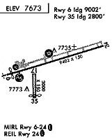
Runways
Runway Summary
| Runways: | 06/24 17/35 |
| Longest Runway: | 06/24 is 9400 ft (2865 m) long |
| Runways with an Instrument Approach: | 06 |
GUC Airport Runway Details
| Runway 06/24 | 9400 ft x 150 ft (2865 m x 46 m) | |
| Runway Length Source: | 3RD PARTY SURVEY as of 09/09/2014 | |
| Surface: | Asphalt - Excellent condition - Saw-cut or plastic grooved | |
| Runway Pavement Class: | 40 /F/A/X/T | |
| Runway Edge Lights: | High Intensity | |
Runway Weight Bearing Capacity (in thousands of pounds) |
||
| Single Wheel Landing Gear: | 75.0 | |
| Dual Wheel Landing Gear: | 160.0 | |
| Dual Tandem Wheel Landing Gear: | 250.0 | |
Runway 06 |
Runway 24 |
|
Elevation: |
7658.0 | 7679.5 |
Latitude: |
38-31-56.7837N | 38-32-23.0677N |
Longitude: |
106-56-42.3105W | 106-54-48.8867W |
|
Runway True Alignment: |
074 | 254 |
ILS Type: |
ILS/DME | |
Glide Path Angle: |
3.2 degrees | 3.6 degrees |
Traffic Pattern: |
Right | Left |
Runway Markings Type: |
Precision Instrument | Nonprecision Instrument |
Runway Markings Condition: |
Good | Good |
Visual Glide Slope Indicators: |
4-Light PAPI On Left Side Of Runway | 4-Light PAPI On Left Side Of Runway |
Approach Light System: |
1,400 Foot Medium Intensity Approach Lighting System With Sequenced Flashers | |
REIL: |
Yes | |
Threshold Crossing Height: |
49 | 71 |
Declared Distances |
||
Take Off Run Avbl. (TORA): |
9400 | 9400 |
Take Off Distance Avbl. (TODA): |
9400 | 9400 |
Actual Stop Dist. Avbl. (ASDA): |
9400 | 9400 |
Landing Dist. Avbl. (LDA): |
9400 | 9400 |
| Runway 17/35 | 2981 ft x 150 ft (909 m x 46 m) | |
| Runway Length Source: | 3RD PARTY SURVEY as of 09/09/2014 | |
| Surface: | Asphalt - Excellent condition - No special surface treatment | |
Runway 17 |
Runway 35 |
|
Elevation: |
7660.9 | 7647.3 |
Latitude: |
38-31-58.1765N | 38-31-28.7193N |
Longitude: |
106-56-21.8160W | 106-56-21.8316W |
|
Runway True Alignment: |
180 | 000 |
Glide Path Angle: |
0.0 degrees | 0.0 degrees |
Traffic Pattern: |
Right | Left |
Runway Markings Type: |
None | None |
Runway Markings Condition: |
Fair | Fair |
Threshold Elevation: |
7648.5 | |
Displaced Threshold: |
233 | |
Threshold Latitude: |
38-31-31.0175N | |
Threshold Longitude: |
106-56-21.8312W | |
Declared Distances |
||
Take Off Run Avbl. (TORA): |
2981 | 2981 |
Take Off Distance Avbl. (TODA): |
2981 | 2981 |
Actual Stop Dist. Avbl. (ASDA): |
2981 | 2981 |
Landing Dist. Avbl. (LDA): |
2981 | 2748 |
Services
Airframe Repair: |
Major |
Powerplant Repair: |
Major |
Bottled Oxygen: |
None |
Bulk Oxygen: |
High Pressure |
Fuel Available: |
100LL, Jet A |
Landing Fees: |
No |
Parking: |
Hangars and tiedowns available |
Maps & Diagrams
GUC Sectional
Flight Planning
at skyvector.com
at skyvector.com