Location
Latitude: |
34-39-14.6000N (34.654056) |
Longitude: |
086-56-43.3000W (-86.945361) |
Elevation: |
592.0 feet MSL (180 m MSL) |
Magnetic Variation: |
3.9 W (as of April 2024 from WMM2020 model) |
Time Zone: |
UTC -6.0 (Standard Time) UTC -5.0 (Daylight Savings Time) |
From City: |
03 N.M. NE of Decatur, Alabama |
Found On: |
Atlanta Chart |
FAA Region: |
ASO |
Contacts
Manager: |
Publicly owned: |
| ADAM FOX PRYOR FIELD AIRPORT AUTHORITY, P.O. BOX 1182 DECATUR, AL 35602 256-355-5770 |
DECATUR/ATHENS AIRPORT AUTHORITY P.O. BOX 1182 DECATUR, AL 35612 256-355-5770 |
Operations
Airport Status: |
Operational |
Facility Use: |
Public |
Type: |
Airport |
Activation Date: |
09/1942 |
Control tower: |
No |
Attendance (Months/Days/Hours): |
Months/Days/Hours MAR-NOV/MON-FRI/0700-1900 |
Boundary ARTCC: |
ZME (Memphis) |
Responsible ARTCC: |
ZME (Memphis) |
Lighting Schedule: |
SEE RMK |
Segmented Circle Indicator: |
Yes |
Traffic Pattern Altitude (MSL): |
1592 feet (485 m) |
NOTAMs Facility: |
DCU |
NOTAM-D Service: |
Yes |
International Airport of Entry: |
No |
Customs Landing Rights: |
Yes |
Military Landing Rights: |
Yes |
Civil/Military Joint Use: |
No |
Based Aircraft
| Single Engine: | 117 |
| Multi Engine: | 14 |
| Jet Engine: | 5 |
| GA Helicopters: | 6 |
| Gliders: | 1 |
Annual Operations (as of 05/31/2019)
| Total Operations: | 167701 | |
| Air Taxi: | 3800 | 2.3% |
| GA Local: | 40184 | 24.0% |
| GA Itinerant: | 111642 | 66.6% |
| Military Aircraft: | 12075 | 7.2% |
Communications
| CTAF: | 123.075 |
| Unicom: | 123.075 |
| Approach: | HUNTSVILLE 118.05 118.05 MEMPHIS ARTCC |
| Departure: | HUNTSVILLE 118.05 118.05 MEMPHIS ARTCC |
| ASOS: | 118.375 (256-350-4270) |
- APCH/DEP SVC PRVDD BY MEMPHIS ARTCC ON FREQS 120.8/307.0 (HUNTSVILLE RCAG) WHEN HUNTSVILLE APCH CTL CLSD.
Fixed Based Operators (FBOs) & Fuel
(Click on a business for detail)
Please help us keep this information up to date. This is a FREE SERVICE just like everything else on Airport Guide! If you see that a business needs to be added, modified, or deleted please fill out our Update Form.
To add, modify, or delete a business click here.
Please help us keep this information up to date. This is a FREE SERVICE just like everything else on Airport Guide! If you see that a business needs to be added, modified, or deleted please fill out our Update Form.
Area Code: 256 |
| Business Name | Frequency | Phone | Fuel Grade |
|---|---|---|---|
| Decatur-Athens Aero Services
Update FBO info |
Unicom 123.0 | 355-5770, -6159 | 100LL, Jet A |
Flight Service Stations
| Primary | Alternate | |
| FSS on Field: | N | |
| FSS Name (ID): | Anniston(ANB) | |
| Frequency: | ||
| Toll Free Phone: | 1-800-WX-BRIEF |
Instrument Procedures / Charts
FAA Terminal Procedures valid from 0901Z 03/21/24 to 0901Z 04/18/24.
There are various types of charts available for an airport. They are listed in the Page Type column. Here is a legend for those types:
APD - Airport Diagram
DP - Departure Procedure Charts
HOT - Hot Spots
IAP - Instrument Approach Procedure Charts
MIN - Minimums
STAR - Standard Terminal Arrival Charts
| Page Type | Page Name | Volume | Action Since Last Cycle |
|---|---|---|---|
| IAP | ILS OR LOC RWY 18 | SE-4 | |
| IAP | RNAV (GPS) RWY 18 | SE-4 | |
| IAP | RNAV (GPS) RWY 36 | SE-4 | |
| MIN | ALTERNATE MINIMUMS | SE-4 | |
| MIN | TAKEOFF MINIMUMS | SE-4 |
Terminal Procedures are only available for airports in several countries with more being added all the time. If you are looking for a specific country's charts, please send an email to support(at)airportguide.com stating the country name. This will be used to prioritize the implementation.
Navigation Aids (Navaids) near DCU
| Dist (NM) | ID | Morse Code | Name | Type | Freq | True Hdg | Mag Hdg |
|---|---|---|---|---|---|---|---|
| 0.5 | DCU | _ . . _ . _ . . . _ | Decatur | DME | 112.8 | 140 | 144 |
| 8.5 | HSV | . . . . . . . . . . _ | Huntsville | VOT | 111.00 | 95 | 99 |
| 10.9 | CWH | _ . _ . . _ _ . . . . | Capshaw | NDB | 350 | 48 | 52 |
| 13.0 | HUA | . . . . . . _ . _ | Redstone | NDB | 287 | 77 | 81 |
| 17.6 | RQZ | . _ . _ _ . _ _ _ . . | Rocket | VORTAC | 112.20 | 60 | 64 |
| 27.1 | MSL | _ _ . . . . _ . . | Muscle Shoals | DME | 116.25 | 276 | 280 |
| 35.0 | TNY | _ _ . _ . _ _ | Kelso | NDB | 358 | 34 | 38 |
| 38.2 | LRT | . _ . . . _ . _ | Lawrenceburg | NDB | 269 | 336 | 340 |
| 43.1 | ARF | . _ . _ . . . _ . | Saratoga | NDB | 296 | 123 | 127 |
| 51.2 | LUG | . _ . . . . _ _ _ . | Verona | NDB | 251 | 7 | 11 |
| 53.4 | BGF | _ . . . _ _ . . . _ . | Boiling Fork | NDB | 263 | 53 | 57 |
| 55.1 | SYI | . . . _ . _ _ . . | Bomar | FAN MARKER | 25 | 29 | |
| 55.5 | UXM | . . _ _ . . _ _ _ | Tullahoma Regional | VOR | 109.65 | 38 | 42 |
| 57.7 | PBC | . _ _ . _ . . . _ . _ . | Maury County | NDB | 365 | 352 | 356 |
| 59.0 | GAD | _ _ . . _ _ . . | Gadsden | VOR-DME | 112.30 | 133 | 137 |
| 59.0 | JHG | . _ _ _ . . . . _ _ . | Hohenwald | NDB | 257 | 325 | 329 |
| 59.1 | VUZ | . . . _ . . _ _ _ . . | Vulcan | VORTAC | 114.40 | 177 | 181 |
| 59.4 | HAB | . . . . . _ _ . . . | Hamilton | DME | 110.4 | 242 | 246 |
| 59.5 | ULH | . . _ . _ . . . . . . | Burwi | NDB | 332 | 35 | 39 |
| 59.9 | SYI | . . . _ . _ _ . . | Shelbyville | VOR-DME | 113.55 | 24 | 28 |
Nearby Airports with Fuel
Notices to Airmen (NOTAMS)
Remarks
| A110-1 | FOR CD CTC HUNTSVILLE APCH AT 256-542-2070. WHEN APCH CLSD CTC MEMPHIS ARTCC AT 901-368-8453/8449. |
| A110-2 | ARPT UNATTD THANKSGIVING, CHRISTMAS, NEW YEARS |
| A17 | FOR ATTENDANT AFT HRS CALL 256-280-1184 |
| A32-18/36 | 25 FT PAVED SHOULDERS WITH GRASS. |
| A81-APT | ACTVT REIL RWYS 18 & 36; PAPI RWY 36; HIRL RWY 18/36- CTAF. |
Runways
Runway Summary
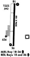
| Runways: | 18/36 |
| Longest Runway: | 18/36 is 6107 ft (1861 m) long |
| Runways with an Instrument Approach: | 18 |
DCU Airport Runway Details
| Runway 18/36 | 6107 ft x 100 ft (1861 m x 30 m) | |
| Runway Length Source: | STATE as of 01/12/2006 | |
| Surface: | Asphalt - Fair condition - Saw-cut or plastic grooved | |
| Runway Pavement Class: | 35 /F/B/X/T | |
| Runway Edge Lights: | High Intensity | |
Runway Weight Bearing Capacity (in thousands of pounds) |
||
| Single Wheel Landing Gear: | 75.0 | |
| Dual Wheel Landing Gear: | 125.0 | |
| Dual Tandem Wheel Landing Gear: | 150.0 | |
Runway 18 |
Runway 36 |
|
Elevation: |
588.0 | 583.3 |
Latitude: |
34-39-44.7800N | 34-38-44.3900N |
Longitude: |
086-56-42.5900W | 086-56-44.0200W |
|
Runway True Alignment: |
181 | 001 |
ILS Type: |
ILS/DME | |
Glide Path Angle: |
0.0 degrees | 3.0 degrees |
Traffic Pattern: |
Left | Left |
Runway Markings Type: |
Precision Instrument | Precision Instrument |
Runway Markings Condition: |
Fair | Fair |
Visual Glide Slope Indicators: |
2-Light PAPI On Left Side Of Runway | |
REIL: |
Yes | Yes |
Threshold Crossing Height: |
50 |
Services
Fuel Available: |
100LL, Jet A+, MOGAS |
Landing Fees: |
No |
Parking: |
Hangars and tiedowns available |
Maps & Diagrams
DCU Sectional
Flight Planning
at skyvector.com
at skyvector.com