Location
Latitude: |
39-54-08.1080N (39.902252) |
Longitude: |
084-13-09.8840W (-84.219412) |
Elevation: |
1009.1 feet MSL (308 m MSL) |
Magnetic Variation: |
6.4 W (as of April 2024 from WMM2020 model) |
Time Zone: |
UTC -5.0 (Standard Time) UTC -4.0 (Daylight Savings Time) |
From City: |
09 N.M. N of Dayton, Ohio |
Found On: |
Cincinnati Chart |
FAA Region: |
AGL |
Contacts
Manager: |
Publicly owned: |
| GILBERT TURNER 3600 TERMINAL DR STE 300 VANDALIA, OH 45377-1095 937-454-8202 |
CITY OF DAYTON, OHIO 101 W 3RD ST DAYTON, OH 45402-1859 937-333-3600 |
Operations
Airport Status: |
Operational |
Facility Use: |
Public |
Type: |
Airport |
Activation Date: |
10/1937 |
Control tower: |
Yes |
Attendance (Months/Days/Hours): |
Months/Days/Hours ALL/ALL/ALL |
Boundary ARTCC: |
ZID (Indianapolis) |
Responsible ARTCC: |
ZID (Indianapolis) |
Lighting Schedule: |
SS-SR |
Segmented Circle Indicator: |
No |
Traffic Pattern Altitude (MSL): |
2009 feet (612 m) |
NOTAMs Facility: |
DAY |
NOTAM-D Service: |
Yes |
International Airport of Entry: |
No |
Customs Landing Rights: |
Yes |
Military Landing Rights: |
Yes |
Civil/Military Joint Use: |
No |
Aircraft Rescue and Firefighting: |
Class I ARFF Index: B Air Carrier Service: Scheduled Certification Date: 05/1973 |
Based Aircraft
| Single Engine: | 14 |
| Multi Engine: | 10 |
| Jet Engine: | 15 |
Annual Operations (as of 12/31/2022)
| Total Operations: | 39590 | |
| Commercial: | 14030 | 35.4% |
| Air Taxi: | 10674 | 27.0% |
| GA Local: | 2666 | 6.7% |
| GA Itinerant: | 11690 | 29.5% |
| Military Aircraft: | 530 | 1.3% |
Communications
| Unicom: | 122.950 |
| Tower: | DAYTON TOWER 119.9 257.7 Hrs: 24 |
| Clearance Del.: | 121.75 |
| Ground: | 121.9 |
| Approach: | COLUMBUS |
| Departure: | COLUMBUS |
| ATIS: | 125.8 Hrs: 24 |
| ASOS: | (937-415-6819) |
| EMERG: | 121.5 |
| EMERG: | 243.0 |
- COMMUNICATIONS PRVDD BY DAYTON RADIO ON FREQS 122.1R/114.5T (DAYTON RCO).
Fixed Based Operators (FBOs) & Fuel
(Click on a business for detail)
Please help us keep this information up to date. This is a FREE SERVICE just like everything else on Airport Guide! If you see that a business needs to be added, modified, or deleted please fill out our Update Form.
To add, modify, or delete a business click here.
Please help us keep this information up to date. This is a FREE SERVICE just like everything else on Airport Guide! If you see that a business needs to be added, modified, or deleted please fill out our Update Form.
Area Code: 937 |
| Business Name | Frequency | Phone | Fuel Grade |
|---|---|---|---|
| Aviation Sales
Update FBO info |
Unicom 122.95 | 898-3927 | 100LL, Jet A |
| Dallas Airmotive
Website Update FBO info |
890-8276 | ||
| Stevens Aviation, Inc.
Update FBO info |
800-359-7232, 454-3400 | 100LL, Jet A | |
| Wright Brothers Aero
Update FBO info |
890-8900 | 100LL, Jet A |
Flight Service Stations
| Primary | Alternate | |
| FSS on Field: | N | |
| FSS Name (ID): | Dayton(DAY) | |
| Frequency: | ||
| Toll Free Phone: | 1-800-WX-BRIEF |
Instrument Procedures / Charts
FAA Terminal Procedures valid from 0901Z 03/21/24 to 0901Z 04/18/24.
There are various types of charts available for an airport. They are listed in the Page Type column. Here is a legend for those types:
APD - Airport Diagram
DP - Departure Procedure Charts
HOT - Hot Spots
IAP - Instrument Approach Procedure Charts
MIN - Minimums
STAR - Standard Terminal Arrival Charts
| Page Type | Page Name | Volume | Action Since Last Cycle |
|---|---|---|---|
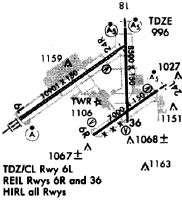
| APD | AIRPORT DIAGRAM | EC-2 | |
| DP | DAYTON SEVEN | EC-2 | |
| DP | DAYTON SEVEN[DELIMITER] CONT.1 | EC-2 | |
| HOT | HOT SPOT | EC-2 | |
| IAP | ILS OR LOC RWY 06L | EC-2 | |
| IAP | ILS OR LOC RWY 18 | EC-2 | Changed |
| IAP | ILS OR LOC RWY 24L | EC-2 | |
| IAP | ILS OR LOC RWY 24R | EC-2 | |
| IAP | ILS RWY 06L (CAT II - III) | EC-2 | |
| IAP | RNAV (GPS) RWY 06R | EC-2 | |
| IAP | RNAV (GPS) RWY 18 | EC-2 | |
| IAP | RNAV (GPS) RWY 24L | EC-2 | |
| IAP | RNAV (GPS) RWY 36 | EC-2 | |
| IAP | RNAV (GPS) Z RWY 06L | EC-2 | |
| IAP | RNAV (GPS) Z RWY 24R | EC-2 | |
| IAP | RNAV (RNP) Y RWY 06L | EC-2 | |
| IAP | RNAV (RNP) Y RWY 24R | EC-2 | |
| MIN | ALTERNATE MINIMUMS | EC-2 | |
| MIN | TAKEOFF MINIMUMS | EC-2 | |
| STAR | DANEI THREE | EC-2 | |
| STAR | KEKEE FOUR | EC-2 |
Terminal Procedures are only available for airports in several countries with more being added all the time. If you are looking for a specific country's charts, please send an email to support(at)airportguide.com stating the country name. This will be used to prioritize the implementation.
Navigation Aids (Navaids) near DAY
| Dist (NM) | ID | Morse Code | Name | Type | Freq | True Hdg | Mag Hdg |
|---|---|---|---|---|---|---|---|
| 0.3 | DAY | _ . . . _ _ . _ _ | Dayton J M Cox-Day | VOT | 111.00 | 142 | 148 |
| 6.3 | AT | . _ _ | Bruny | NDB | 315 | 238 | 244 |
| 9.1 | FFO | . . _ . . . _ . _ _ _ | Patterson | TACAN | 109.20 | 123 | 129 |
| 10.7 | DQN | _ . . _ _ . _ _ . | Dayton | VOR-DME | 114.50 | 310 | 316 |
| 17.7 | SGH | . . . _ _ . . . . . | Springfield | DME | 113.2 | 102 | 109 |
| 17.9 | XSF | _ . . _ . . . . . _ . | Springfield | TACAN | 133.80 | 102 | 109 |
| 20.0 | MW | _ _ . _ _ | Onida | NDB | 223 | 193 | 199 |
| 20.3 | CCJ | _ . _ . _ . _ . . _ _ _ | Clark County | NDB | 341 | 94 | 101 |
| 24.5 | ROD | . _ . _ _ _ _ . . | Rosewood | VORTAC | 117.50 | 19 | 25 |
| 26.4 | HKF | . . . . _ . _ . . _ . | Hook Field | NDB | 239 | 203 | 209 |
| 29.9 | RID | . _ . . . _ . . | Richmond | DME | 110.6 | 252 | 258 |
| 33.1 | IL | . . . _ . . | Airbo | NDB | 407 | 137 | 144 |
| 34.3 | MXQ | _ _ _ . . _ _ _ . _ | Midwest | VOR-DME | 112.90 | 145 | 152 |
| 35.1 | OXD | _ _ _ _ . . _ _ . . | Oxford | NDB | 282 | 227 | 233 |
| 35.7 | HAO | . . . . . _ _ _ _ | Hamilton | NDB | 260 | 207 | 213 |
| 36.6 | HW | . . . . . _ _ | Cubla | NDB | 299 | 154 | 160 |
| 38.2 | CQA | _ . _ . _ _ . _ . _ | Lakefield | NDB | 205 | 335 | 341 |
| 41.3 | MDE | _ _ _ . . . | Madeira | NDB | 379 | 188 | 194 |
| 41.9 | RUV | . _ . . . _ . . . _ | Rushsylvania | NDB | 326 | 36 | 43 |
| 42.3 | CSS | _ . _ . . . . . . . | Court House | NDB | 414 | 115 | 122 |
Nearby Airports with Fuel
Notices to Airmen (NOTAMS)
Remarks
| A110-10 | SIERRA NEVADA RAMP NORTH OF RWY 06L/24R EDGE LGT NOT STD. |
| A110-11 | TWY M NORTH OF RWY 06L/24R CLSD EXC 24HR PPR 937-454-2010. |
| A110-3 | RUNUPS PROHIBITED IN RWY 24L HLDG AREA. |
| A110-4 | TWY W CLSD INDEFLY. TWYS Z, M, T, S CLSD BTN RWY 06L/24R AND TWY W INDEFLY. |
| A110-5 | DEER, COYOTES, BIRDS, & WATERFOWL ON & INVOF ARPT. |
| A110-7 | TWY C BTN TWY N & TWY Z NOT AVBL FOR GROUPS IV AND HIGHER. TWY K, TWY H & TWY J NOT AVBL FOR GROUP IV AND HIGHER ACFT. |
| A110-8 | TWY M NORTH OF RWY 06L/24R CLSD TO ACRS. |
| A110-9 | TWY M NORTH OF RWY 06L/24R EDGE LGT NOT STD. |
| A33-06L/24R | NE 1400 FT CONC, SW 9501 FT ASPH. |
Runways
Runway Summary
| Runways: | 06L/24R 06R/24L 18/36 |
| Longest Runway: | 06L/24R is 10901 ft (3323 m) long |
| Runways with an Instrument Approach: | 06L, 24R, 24L, 18 |
DAY Airport Runway Details
| Runway 06L/24R | 10901 ft x 150 ft (3323 m x 46 m) | |
| Runway Length Source: | 3RD PARTY SURVEY as of 01/22/2020 | |
| Surface: | Asphalt/Concrete - Good condition - Saw-cut or plastic grooved | |
| Runway Pavement Class: | 100/R/B/W/T | |
| Runway Edge Lights: | High Intensity | |
Runway Weight Bearing Capacity (in thousands of pounds) |
||
| Single Wheel Landing Gear: | 100.0 | |
| Dual Wheel Landing Gear: | 210.0 | |
| Dual Tandem Wheel Landing Gear: | 583.0 | |
| Dual Dual Tandem Wheel Landing Gear: | 870.0 | |
Runway 06L |
Runway 24R |
|
Elevation: |
997.9 | 995.6 |
Latitude: |
39-53-42.3897N | 39-54-43.6504N |
Longitude: |
084-14-45.6642W | 084-12-50.6152W |
|
Runway True Alignment: |
055 | 235 |
ILS Type: |
ILS | ILS/DME |
Glide Path Angle: |
3.0 degrees | 3.0 degrees |
Traffic Pattern: |
Left | Left |
Runway Markings Type: |
Precision Instrument | Precision Instrument |
Runway Markings Condition: |
Good | Good |
Object at End: |
TREE | |
Object Height: |
75 | |
Distance from End: |
3417 | |
Object Centerline Offset: |
197 ft. right of centerline | |
Visual Glide Slope Indicators: |
4-Light PAPI On Left Side Of Runway | 4-Light PAPI On Left Side Of Runway |
Runway Visual Range (RVR): |
Touchdown, Midfield, Rollout | Touchdown, Midfield, Rollout |
Approach Light System: |
Standard 2,400 Foot High Intensity Approach Lighting System With Sequenced Flashers, Cat. II or III Config. | 1,400 Foot Medium Intensity Approach Lighting System With Runway Alignment Indicator Lights |
REIL: |
No | No |
Touchdown Lights: |
Yes | No |
Centerline Lights: |
Yes | Yes |
Threshold Crossing Height: |
67 | 56 |
Declared Distances |
||
Take Off Run Avbl. (TORA): |
10900 | 10900 |
Take Off Distance Avbl. (TODA): |
10900 | 10900 |
Actual Stop Dist. Avbl. (ASDA): |
10900 | 10900 |
Landing Dist. Avbl. (LDA): |
10900 | 10900 |
| Runway 06R/24L | 7285 ft x 150 ft (2220 m x 46 m) | |
| Runway Length Source: | 3RD PARTY SURVEY as of 01/22/2020 | |
| Surface: | Asphalt/Concrete - Good condition - Saw-cut or plastic grooved | |
| Runway Pavement Class: | 57 /R/A/W/T | |
| Runway Edge Lights: | High Intensity | |
Runway Weight Bearing Capacity (in thousands of pounds) |
||
| Single Wheel Landing Gear: | 100.0 | |
| Dual Wheel Landing Gear: | 210.0 | |
| Dual Tandem Wheel Landing Gear: | 583.0 | |
| Dual Dual Tandem Wheel Landing Gear: | 870.0 | |
Runway 06R |
Runway 24L |
|
Elevation: |
1005.0 | 1001.1 |
Latitude: |
39-53-25.9851N | 39-54-06.9104N |
Longitude: |
084-13-23.6495W | 084-12-06.7573W |
|
Runway True Alignment: |
055 | 235 |
ILS Type: |
ILS/DME | |
Glide Path Angle: |
3.0 degrees | 3.0 degrees |
Traffic Pattern: |
Left | Left |
Runway Markings Type: |
Precision Instrument | Precision Instrument |
Runway Markings Condition: |
Good | Good |
Object at End: |
TREE | POLE |
Object Height: |
51 | 25 |
Distance from End: |
1230 | 1194 |
Object Centerline Offset: |
197 ft. right of centerline | |
Visual Glide Slope Indicators: |
4-Light PAPI On Left Side Of Runway | 4-Light PAPI On Left Side Of Runway |
Runway Visual Range (RVR): |
Touchdown | |
Approach Light System: |
1,400 Foot Medium Intensity Approach Lighting System With Runway Alignment Indicator Lights | |
REIL: |
Yes | No |
Touchdown Lights: |
No | No |
Centerline Lights: |
No | No |
Threshold Crossing Height: |
50 | 54 |
Declared Distances |
||
Take Off Run Avbl. (TORA): |
7285 | 7285 |
Take Off Distance Avbl. (TODA): |
7285 | 7285 |
Actual Stop Dist. Avbl. (ASDA): |
7001 | 7001 |
Landing Dist. Avbl. (LDA): |
7001 | 7001 |
| Runway 18/36 | 8502 ft x 150 ft (2591 m x 46 m) | |
| Runway Length Source: | 3RD PARTY SURVEY as of 01/22/2020 | |
| Surface: | Asphalt/Concrete - Good condition - Saw-cut or plastic grooved | |
| Runway Pavement Class: | 62 /R/B/W/T | |
| Runway Edge Lights: | High Intensity | |
Runway Weight Bearing Capacity (in thousands of pounds) |
||
| Single Wheel Landing Gear: | 100.0 | |
| Dual Wheel Landing Gear: | 210.0 | |
| Dual Tandem Wheel Landing Gear: | 583.0 | |
| Dual Dual Tandem Wheel Landing Gear: | 870.0 | |
Runway 18 |
Runway 36 |
|
Elevation: |
990.7 | 1007.2 |
Latitude: |
39-55-02.3522N | 39-53-38.3660N |
Longitude: |
084-12-43.3825W | 084-12-40.5594W |
|
Runway True Alignment: |
179 | 359 |
ILS Type: |
ILS | |
Glide Path Angle: |
0.0 degrees | 3.0 degrees |
Traffic Pattern: |
Left | Left |
Runway Markings Type: |
Precision Instrument | Precision Instrument |
Runway Markings Condition: |
Good | Good |
Object at End: |
TREES | TREES |
Object Height: |
56 | 41 |
Distance from End: |
2636 | 1050 |
Object Centerline Offset: |
197 ft. right of centerline | |
Visual Glide Slope Indicators: |
4-Light PAPI On Left Side Of Runway | |
Runway Visual Range (RVR): |
Touchdown | |
Approach Light System: |
1,400 Foot Medium Intensity Approach Lighting System With Runway Alignment Indicator Lights | |
REIL: |
Yes | |
Touchdown Lights: |
No | No |
Centerline Lights: |
No | No |
Threshold Crossing Height: |
60 | |
Declared Distances |
||
Take Off Run Avbl. (TORA): |
8502 | 8502 |
Take Off Distance Avbl. (TODA): |
8502 | 8502 |
Actual Stop Dist. Avbl. (ASDA): |
8502 | 8502 |
Landing Dist. Avbl. (LDA): |
8502 | 8502 |
Services
Airframe Repair: |
None |
Powerplant Repair: |
None |
Bottled Oxygen: |
None |
Bulk Oxygen: |
None |
Fuel Available: |
100LL, Jet A-1+ |
Landing Fees: |
No |
Parking: |
Hangars and tiedowns available |
Maps & Diagrams
DAY Sectional
Flight Planning
at skyvector.com
at skyvector.com