Location
Latitude: |
39-04-07.7628N (39.068823) |
Longitude: |
095-37-20.5533W (-95.622376) |
Elevation: |
881.3 feet MSL (269 m MSL) |
Magnetic Variation: |
1.9 E (as of April 2024 from WMM2020 model) |
Time Zone: |
UTC -6.0 (Standard Time) UTC -5.0 (Daylight Savings Time) |
From City: |
03 N.M. NE of Topeka, Kansas |
Found On: |
Kansas City Chart |
FAA Region: |
ACE |
Contacts
Manager: |
Publicly owned: |
| ERIC M. JOHNSON FORBES FIELD, 6510 SE FORBES AVE TOPEKA, KS 66619 785-862-2362 |
METRO. TOPEKA ARPT AUTH. FORBES FIELD, 6510 SE FORBES AVE TOPEKA, KS 66619 785-862-2362 |
Operations
Airport Status: |
Operational |
Facility Use: |
Public |
Type: |
Airport |
Activation Date: |
04/1940 |
Control tower: |
Yes |
Attendance (Months/Days/Hours): |
Months/Days/Hours ALL/ALL/0700-2100 |
Boundary ARTCC: |
ZKC (Kansas City) |
Responsible ARTCC: |
ZKC (Kansas City) |
Lighting Schedule: |
SEE RMK |
Segmented Circle Indicator: |
No |
Traffic Pattern Altitude (MSL): |
1881 feet (573 m) |
NOTAMs Facility: |
TOP |
NOTAM-D Service: |
Yes |
International Airport of Entry: |
No |
Customs Landing Rights: |
No |
Military Landing Rights: |
Yes |
Civil/Military Joint Use: |
No |
Based Aircraft
| Single Engine: | 68 |
| Multi Engine: | 5 |
| Jet Engine: | 2 |
| GA Helicopters: | 2 |
Annual Operations (as of 07/31/2019)
| Total Operations: | 16447 | |
| Air Taxi: | 543 | 3.3% |
| GA Local: | 6100 | 37.1% |
| GA Itinerant: | 9534 | 58.0% |
| Military Aircraft: | 270 | 1.6% |
Communications
| CTAF: | 118.700 |
| Unicom: | 122.950 |
| Tower: | TOPEKA 118.7 257.8 Hrs: 0700-1900 |
| Clearance Del.: | 121.9 |
| Ground: | 121.9 |
| Approach: | KANSAS CITY ARTCC |
| Departure: | KANSAS CITY ARTCC |
| ASOS: | 121.275 (785-234-1591) |
- APCH/DEP CTL SVC PRVDD BY KANSAS CITY ARTCC (ZKC) ON FREQS 123.8/343.7 (TOPEKA RCAG).
- ATCT OPERATED BY INTERNATIONAL TECHNICAL AVIATION PERSONNEL INC.
Fixed Based Operators (FBOs) & Fuel
(Click on a business for detail)
Please help us keep this information up to date. This is a FREE SERVICE just like everything else on Airport Guide! If you see that a business needs to be added, modified, or deleted please fill out our Update Form.
To add, modify, or delete a business click here.
Please help us keep this information up to date. This is a FREE SERVICE just like everything else on Airport Guide! If you see that a business needs to be added, modified, or deleted please fill out our Update Form.
Area Code: 785 |
| Business Name | Frequency | Phone | Fuel Grade |
|---|---|---|---|
| Capitol Helicopters, Inc.
Update FBO info |
354-7055 | ||
| Hetrick Aircraft, Inc.
Update FBO info |
354-7055 | ||
| Ken Godfrey Aviation, Inc.
Update FBO info |
233-6677, 233-7150 | ||
| T.J. Terminals
Update FBO info |
Unicom 122.95 | 234-2602, 233-0881 | 100LL, Jet A |
Flight Service Stations
| Primary | Alternate | |
| FSS on Field: | N | |
| FSS Name (ID): | Wichita(ICT) | |
| Frequency: | ||
| Toll Free Phone: | 1-800-WX-BRIEF |
Instrument Procedures / Charts
FAA Terminal Procedures valid from 0901Z 03/21/24 to 0901Z 04/18/24.
There are various types of charts available for an airport. They are listed in the Page Type column. Here is a legend for those types:
APD - Airport Diagram
DP - Departure Procedure Charts
HOT - Hot Spots
IAP - Instrument Approach Procedure Charts
MIN - Minimums
STAR - Standard Terminal Arrival Charts
| Page Type | Page Name | Volume | Action Since Last Cycle |
|---|---|---|---|
| APD | AIRPORT DIAGRAM | NC-2 | |
| IAP | ILS OR LOC RWY 13 | NC-2 | |
| IAP | LOC BC RWY 31 | NC-2 | |
| IAP | RNAV (GPS) RWY 13 | NC-2 | |
| IAP | RNAV (GPS) RWY 18 | NC-2 | |
| IAP | RNAV (GPS) RWY 31 | NC-2 | |
| IAP | RNAV (GPS) RWY 36 | NC-2 | |
| MIN | ALTERNATE MINIMUMS | NC-2 | |
| MIN | TAKEOFF MINIMUMS | NC-2 |
Terminal Procedures are only available for airports in several countries with more being added all the time. If you are looking for a specific country's charts, please send an email to support(at)airportguide.com stating the country name. This will be used to prioritize the implementation.
Navigation Aids (Navaids) near TOP
| Dist (NM) | ID | Morse Code | Name | Type | Freq | True Hdg | Mag Hdg |
|---|---|---|---|---|---|---|---|
| 4.3 | TO | _ _ _ _ | Biloy | NDB | 521 | 315 | 313 |
| 5.3 | TOP | _ _ _ _ . _ _ . | Topeka | VORTAC | 117.80 | 39 | 37 |
| 7.3 | FOE | . . _ . _ _ _ . | Forbes | VOT | 111.00 | 196 | 194 |
| 7.5 | FOE | . . _ . _ _ _ . | Forbes | TACAN | 111.60 | 193 | 191 |
| 11.2 | FO | . . _ . _ _ _ | Riply | NDB | 326 | 170 | 168 |
| 23.8 | JZ | . _ _ _ _ _ . . | Newbn | NDB | 338 | 112 | 110 |
| 41.6 | DO | _ . . _ _ _ | Dotte | NDB | 359 | 77 | 75 |
| 43.2 | MCI | _ _ _ . _ . . . | Kansas City | VORTAC | 113.25 | 72 | 70 |
| 43.5 | OJC | _ _ _ . _ _ _ _ . _ . | Johnson County | VOR-DME | 113.00 | 108 | 106 |
| 45.0 | GQ | _ _ . _ _ . _ | Norge | NDB | 517 | 90 | 88 |
| 45.5 | PK | . _ _ . _ . _ | Herbb | NDB | 420 | 114 | 112 |
| 46.4 | UKL | . . _ _ . _ . _ . . | Boyd | NDB | 245 | 185 | 183 |
| 47.8 | MKC | _ _ _ . _ _ . _ . | Kansas City Downtown | VOT | 108.60 | 85 | 83 |
| 47.8 | RBA | . _ . _ . . . . _ | Robinson | DME | 108.2 | 11 | 9 |
| 47.9 | RIS | . _ . . . . . . | Riverside | VOR-DME | 111.40 | 85 | 83 |
| 48.9 | MHK | _ _ . . . . _ . _ | Manhattan | VOR-DME | 110.20 | 275 | 273 |
| 49.3 | ST | . . . _ | Tario | NDB | 260 | 42 | 40 |
| 52.5 | EMP | . _ _ . _ _ . | Emporia | VORTAC | 112.80 | 207 | 205 |
| 54.7 | CVY | _ . _ . . . . _ _ . _ _ | Cavalry | NDB | 314 | 267 | 265 |
| 58.1 | FRI | . . _ . . _ . . . | Fort Riley | VOR | 109.40 | 264 | 262 |
Nearby Airports with Fuel
Notices to Airmen (NOTAMS)
Remarks
| A110-2 | LARGE & SMALL MIGRATORY BIRDS ON & INVOF ARPT. |
| A110-3 | FOR CD IF UNA TO CTC ON FSS FREQ, CTC KANSAS CITY ARTCC AT 913-254-8508. |
| A70-FUEL-10 | 0LL FOR FUEL AFTER HOURS CALL 785-234-2602. |
| A81-APT | WHEN ATCT CLSD ACTVT MALSR RWY 13; REIL RWY 18 & 31; VASI RWY 18 & 31; HIRL RWY 13/31; MIRL RWY 18/36 - CTAF. |
| A82 | MULTICOM - 121.900. |
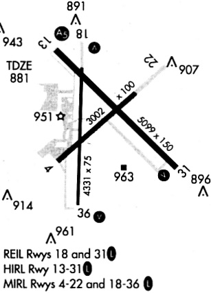
Runways
Runway Summary
| Runways: | 13/31 18/36 |
| Longest Runway: | 13/31 is 5099 ft (1554 m) long |
| Runways with an Instrument Approach: | 13 |
TOP Airport Runway Details
| Runway 13/31 | 5099 ft x 100 ft (1554 m x 30 m) | |
| Runway Length Source: | 3RD PARTY SURVEY as of 07/15/2010 | |
| Surface: | Asphalt - Good condition - No special surface treatment | |
| Runway Pavement Class: | 19 /F/C/Y/U | |
| Runway Edge Lights: | High Intensity | |
Runway Weight Bearing Capacity (in thousands of pounds) |
||
| Single Wheel Landing Gear: | 50.0 | |
| Dual Wheel Landing Gear: | 72.0 | |
| Dual Tandem Wheel Landing Gear: | 110.0 | |
Runway 13 |
Runway 31 |
|
Elevation: |
879.7 | 875.5 |
Latitude: |
39-04-29.2350N | 39-03-54.0141N |
Longitude: |
095-37-37.3650W | 095-36-51.1231W |
|
Runway True Alignment: |
134 | 314 |
ILS Type: |
ILS | |
Glide Path Angle: |
0.0 degrees | 3.0 degrees |
Traffic Pattern: |
Left | Left |
Runway Markings Type: |
Precision Instrument | Precision Instrument |
Runway Markings Condition: |
Good | Good |
Object at End: |
TREE | TREE |
Object Height: |
66 | 56 |
Distance from End: |
1050 | 1942 |
Object Centerline Offset: |
650 ft. right of centerline | 14 ft. right of centerline |
Visual Glide Slope Indicators: |
4-Box VASI On Left Side Of Runway | |
Approach Light System: |
1,400 Foot Medium Intensity Approach Lighting System With Runway Alignment Indicator Lights | |
REIL: |
Yes | |
Threshold Crossing Height: |
55 |
| Runway 18/36 | 4331 ft x 75 ft (1320 m x 23 m) | |
| Runway Length Source: | 3RD PARTY SURVEY as of 07/15/2010 | |
| Surface: | Asphalt - Good condition - No special surface treatment | |
| Runway Pavement Class: | 23 /F/C/Y/U | |
| Runway Edge Lights: | Medium Intensity | |
Runway Weight Bearing Capacity (in thousands of pounds) |
||
| Single Wheel Landing Gear: | 60.0 | |
| Dual Wheel Landing Gear: | 80.0 | |
| Dual Tandem Wheel Landing Gear: | 96.0 | |
Runway 18 |
Runway 36 |
|
Elevation: |
879.8 | 880.7 |
Latitude: |
39-04-24.6120N | 39-03-41.8205N |
Longitude: |
095-37-27.1781W | 095-37-28.7848W |
|
Runway True Alignment: |
182 | 002 |
Glide Path Angle: |
3.0 degrees | 3.0 degrees |
Traffic Pattern: |
Left | Left |
Runway Markings Type: |
Nonprecision Instrument | Nonprecision Instrument |
Runway Markings Condition: |
Fair | Fair |
Object Centerline Offset: |
650 ft. right of centerline | 14 ft. right of centerline |
Visual Glide Slope Indicators: |
4-Box VASI On Left Side Of Runway | 4-Box VASI On Right Side Of Runway |
REIL: |
Yes | |
Threshold Crossing Height: |
35 | 37 |
Services
Airframe Repair: |
Major |
Powerplant Repair: |
Major |
Bottled Oxygen: |
None |
Bulk Oxygen: |
None |
Fuel Available: |
100LL, Jet A |
Landing Fees: |
No |
Parking: |
Hangars and tiedowns available |
Maps & Diagrams
TOP Sectional
Flight Planning
at skyvector.com
at skyvector.com