Location
Latitude: |
40-32-27.6700N (40.541019) |
Longitude: |
084-29-26.4300W (-84.490675) |
Elevation: |
871.0 feet MSL (265 m MSL) |
Magnetic Variation: |
6.3 W (as of April 2024 from WMM2020 model) |
Time Zone: |
UTC -5.0 (Standard Time) UTC -4.0 (Daylight Savings Time) |
From City: |
05 N.M. NE of St. Marys, Ohio |
Found On: |
Detroit Chart |
FAA Region: |
AGL |
Contacts
Manager: |
Publicly owned: |
| DAVID FALER, ASST PARK MGR GRAND LAKE SAINT MARYS STATE PARK, 834 EDGEWATER DR SAINT MARYS, OH 45885-1132 419-394-3611 |
OHIO DIV OF PARKS & REC 834 EDGEWATER DR SAINT MARYS, OH 45885-1132 419-394-3611 |
Operations
Airport Status: |
Operational |
Facility Use: |
Public |
Type: |
Seaplane Base |
Activation Date: |
04/1995 |
Control tower: |
No |
Attendance (Months/Days/Hours): |
Months/Days/Hours APR-NOV/ALL/0800-1700 |
Boundary ARTCC: |
ZID (Indianapolis) |
Responsible ARTCC: |
ZID (Indianapolis) |
Segmented Circle Indicator: |
No |
Traffic Pattern Altitude (MSL): |
1871 feet (570 m) |
NOTAMs Facility: |
DAY |
NOTAM-D Service: |
Yes |
Based Aircraft
Annual Operations (as of 09/27/2022)
| Total Operations: | 12 | |
| GA Itinerant: | 12 | 100.0% |
Communications
| CTAF: | 122.900 |
Fixed Based Operators (FBOs) & Fuel
(Click on a business for detail)
Please help us keep this information up to date. This is a FREE SERVICE just like everything else on Airport Guide! If you see that a business needs to be added, modified, or deleted please fill out our Update Form.
To add, modify, or delete a business click here.
Please help us keep this information up to date. This is a FREE SERVICE just like everything else on Airport Guide! If you see that a business needs to be added, modified, or deleted please fill out our Update Form.
Area Code: 419 |
| Business Name | Frequency | Phone | Fuel Grade |
|---|
Flight Service Stations
| Primary | Alternate | |
| FSS on Field: | N | |
| FSS Name (ID): | Dayton(DAY) | |
| Frequency: | ||
| Toll Free Phone: | 1-800-WX-BRIEF |
Instrument Procedures / Charts
Terminal Procedures are only available for airports in several countries with more being added all the time. If you are looking for a specific country's charts, please send an email to support(at)airportguide.com stating the country name. This will be used to prioritize the implementation.
Navigation Aids (Navaids) near O12
| Dist (NM) | ID | Morse Code | Name | Type | Freq | True Hdg | Mag Hdg |
|---|---|---|---|---|---|---|---|
| 4.9 | CQA | _ . _ . _ _ . _ . _ | Lakefield | NDB | 205 | 223 | 229 |
| 20.1 | VFU | . . . _ . . _ . . . _ | Stanley | NDB | 411 | 343 | 349 |
| 25.5 | ROD | . _ . _ _ _ _ . . | Rosewood | VORTAC | 117.50 | 126 | 132 |
| 25.8 | AOH | . _ _ _ _ . . . . | Allen County | VOR | 108.40 | 67 | 74 |
| 31.8 | DQN | _ . . _ _ . _ _ . | Dayton | VOR-DME | 114.50 | 172 | 178 |
| 37.9 | RUV | . _ . . . _ . . . _ | Rushsylvania | NDB | 326 | 97 | 104 |
| 40.6 | DAY | _ . . . _ _ . _ _ | Dayton J M Cox-Day | VOT | 111.00 | 161 | 167 |
| 41.2 | FWA | . . _ . . _ _ . _ | Fort Wayne | VORTAC | 117.80 | 309 | 315 |
| 41.3 | FWA | . . _ . . _ _ . _ | Fort Wayne Baer | VOT | 111.00 | 309 | 315 |
| 41.6 | FBC | . . _ . _ . . . _ . _ . | Flag City | VORTAC | 108.20 | 53 | 60 |
| 42.3 | AT | . _ _ | Bruny | NDB | 315 | 170 | 176 |
| 43.7 | JN | . _ _ _ _ . | Balll | NDB | 365 | 240 | 246 |
| 45.1 | MIE | _ _ . . . | Muncie | VOR-DME | 114.40 | 246 | 252 |
| 47.2 | BNR | _ . . . _ . . _ . | Benton Ridge | NDB | 334 | 52 | 59 |
| 47.7 | FFO | . . _ . . . _ . _ _ _ | Patterson | TACAN | 109.20 | 155 | 161 |
| 48.1 | HHG | . . . . . . . . _ _ . | Huntington | NDB | 417 | 293 | 299 |
| 49.8 | RID | . _ . . . _ . . | Richmond | DME | 110.6 | 198 | 204 |
| 50.4 | GW | _ _ . . _ _ | Shenk | NDB | 227 | 336 | 342 |
| 51.6 | SGH | . . . _ _ . . . . . | Springfield | DME | 113.2 | 144 | 150 |
| 51.6 | CCJ | _ . _ . _ . _ . . _ _ _ | Clark County | NDB | 341 | 140 | 147 |
Nearby Airports with Fuel
Notices to Airmen (NOTAMS)
Remarks
| A110-1 | NO NGT OPS. |
| A110-2 | NO PUB DOCKS; PPR FOR PVT DOCK TIE UP; CALL KOZY MARINA 419-394-8797. |
| A110-3 | FOR CD CTC COLUMBUS APCH AT 614-338-8537. |
| A16 | CELL 419-656-7060. |
| A17 | ARPT CLSD NOV 15 TO APR 1 & MEMORIAL & LABOR DAY. |
| A70-FUEL-10 | 0LL 100LL AVBL ON REQ, PPR, CTC KOZY MARINA 419-394-8797. |
| A82 | ACFT OPRG AT GRAND LAKE ST MARYS SHOULD MNT TFC ON LAKEFIELD CTAF & NEIL ARMSTRONG CTAF. |
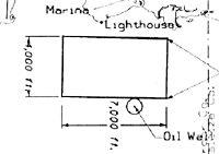
| E111 | PRVDD 20:1 APCH; OIL WELL TO THE S MKD & LGTD; SEA LANES MKD & LGTD PER AC 150/5395-1. |
Runways
Runway Summary
| Runways: | 09W/27W |
| Longest Runway: | 09W/27W is 7000 ft (2134 m) long |
| Runways with an Instrument Approach: |
O12 Airport Runway Details
| Waterway 09W/27W | 7000 ft x 4000 ft (2134 m x 1219 m) | |
| Surface: | Water - No special surface treatment | |
Waterway 09W |
Runway 27W |
|
Glide Path Angle: |
0.0 degrees | 0.0 degrees |
Traffic Pattern: |
Right | |
Runway Markings Type: |
Buoys (Seaplane Base) | Buoys (Seaplane Base) |
Runway Markings Condition: |
Good | Good |
Services
Airframe Repair: |
Major |
Powerplant Repair: |
Major |
Fuel Available: |
100LL, Jet A |
Landing Fees: |
No |
Parking: |
Tiedowns available |
Maps & Diagrams
O12 Sectional
Flight Planning
at skyvector.com
at skyvector.com