Location
Latitude: |
33-43-11.9321N (33.719981) |
Longitude: |
093-39-32.0534W (-93.658904) |
Elevation: |
359.2 feet MSL (109 m MSL) |
Magnetic Variation: |
0.7 E (as of April 2024 from WMM2020 model) |
Time Zone: |
UTC -6.0 (Standard Time) UTC -5.0 (Daylight Savings Time) |
From City: |
04 N.M. NW of Hope, Arkansas |
Found On: |
Memphis Chart |
FAA Region: |
ASW |
Contacts
Manager: |
Publicly owned: |
| DARRELL ALLEN PO BOX 667 HOPE, AR 71802 870-777-3444 |
CITY OF HOPE PO BOX 667 HOPE, AR 71802 870-777-6701 |
Operations
Airport Status: |
Operational |
Facility Use: |
Public |
Type: |
Airport |
Activation Date: |
07/1944 |
Control tower: |
No |
Attendance (Months/Days/Hours): |
Months/Days/Hours ALL/MON-THU/0600-1630 |
Boundary ARTCC: |
ZFW (Fort Worth) |
Responsible ARTCC: |
ZFW (Fort Worth) |
Lighting Schedule: |
SEE RMK |
Segmented Circle Indicator: |
Yes |
Traffic Pattern Altitude (MSL): |
1359 feet (414 m) |
NOTAMs Facility: |
JBR |
NOTAM-D Service: |
Yes |
International Airport of Entry: |
No |
Customs Landing Rights: |
No |
Military Landing Rights: |
Yes |
Civil/Military Joint Use: |
No |
Based Aircraft
| Single Engine: | 17 |
| Multi Engine: | 1 |
Annual Operations (as of 11/30/2023)
| Total Operations: | 8000 | |
| GA Local: | 2500 | 31.2% |
| GA Itinerant: | 5000 | 62.5% |
| Military Aircraft: | 500 | 6.2% |
Communications
| CTAF: | 122.800 |
| Unicom: | 122.800 |
- APCH/DEP CTL SVC PRVDD BY FORT WORTH ARTCC (ZFW) ON FREQS 123.925/269.475 (TEXARKANA RCAG).
Fixed Based Operators (FBOs) & Fuel
(Click on a business for detail)
Please help us keep this information up to date. This is a FREE SERVICE just like everything else on Airport Guide! If you see that a business needs to be added, modified, or deleted please fill out our Update Form.
To add, modify, or delete a business click here.
Please help us keep this information up to date. This is a FREE SERVICE just like everything else on Airport Guide! If you see that a business needs to be added, modified, or deleted please fill out our Update Form.
Area Code: 870 |
| Business Name | Frequency | Phone | Fuel Grade |
|---|---|---|---|
| Southwest Arkansas Aviation
Update FBO info |
Unicom 122.8 | 777-3444 | 100LL, Jet A |
Flight Service Stations
| Primary | Alternate | |
| FSS on Field: | N | |
| FSS Name (ID): | Jonesboro(JBR) | |
| Frequency: | ||
| Toll Free Phone: | 1-800-WX-BRIEF |
Instrument Procedures / Charts
FAA Terminal Procedures valid from 0901Z 03/21/24 to 0901Z 04/18/24.
There are various types of charts available for an airport. They are listed in the Page Type column. Here is a legend for those types:
APD - Airport Diagram
DP - Departure Procedure Charts
HOT - Hot Spots
IAP - Instrument Approach Procedure Charts
MIN - Minimums
STAR - Standard Terminal Arrival Charts
| Page Type | Page Name | Volume | Action Since Last Cycle |
|---|---|---|---|
| IAP | RNAV (GPS) RWY 04 | SC-1 | Changed |
| IAP | RNAV (GPS) RWY 16 | SC-1 | Changed |
| IAP | RNAV (GPS) RWY 22 | SC-1 | Changed |
| IAP | VOR RWY 04 | SC-1 | Changed |
| MIN | TAKEOFF MINIMUMS | SC-1 |
Terminal Procedures are only available for airports in several countries with more being added all the time. If you are looking for a specific country's charts, please send an email to support(at)airportguide.com stating the country name. This will be used to prioritize the implementation.
Navigation Aids (Navaids) near M18
| Dist (NM) | ID | Morse Code | Name | Type | Freq | True Hdg | Mag Hdg |
|---|---|---|---|---|---|---|---|
| 0.4 | HPC | . . . . . _ _ . _ . _ . | Hope | NDB | 362 | 105 | 104 |
| 17.0 | TX | _ _ . . _ | Tecco | NDB | 234 | 226 | 225 |
| 24.1 | TXK | _ _ . . _ _ . _ | Texarkana | VORTAC | 116.30 | 239 | 238 |
| 34.1 | ADF | . _ _ . . . . _ . | Arkadelphia | NDB | 275 | 53 | 53 |
| 45.5 | ATA | . _ _ . _ | Atlanta | NDB | 347 | 215 | 214 |
| 48.2 | HO | . . . . _ _ _ | Hossy | NDB | 385 | 28 | 27 |
| 53.3 | VM | . . . _ _ _ | Fench | NDB | 352 | 337 | 336 |
| 53.4 | EL | . . _ . . | Lados | NDB | 418 | 118 | 118 |
| 53.6 | HOT | . . . . _ _ _ _ | Hot Springs | VOR-DME | 110.00 | 31 | 31 |
| 53.6 | ELD | . . _ . . _ . . | El Dorado | VOR-DME | 115.50 | 121 | 121 |
| 54.5 | VIV | . . . _ . . . . . _ | Vivian | NDB | 284 | 198 | 197 |
| 57.4 | EIC | . . . _ . _ . | Belcher | VORTAC | 117.40 | 187 | 186 |
| 70.9 | DTN | _ . . _ _ . | Downtown | VOR | 108.60 | 183 | 182 |
| 73.0 | BAD | _ . . . . _ _ . . | Barksdale | TACAN | 115.80 | 180 | 179 |
| 74.5 | PGO | . _ _ . _ _ . _ _ _ | Rich Mountain | VORTAC | 113.50 | 320 | 319 |
| 76.9 | SHV | . . . . . . . . . . _ | Shreveport | VOT | 108.20 | 186 | 185 |
| 79.2 | EMG | . _ _ _ _ . | Elm Grove | VORTAC | 111.20 | 177 | 176 |
| 85.7 | ROQ | . _ . _ _ _ _ _ . _ | Ruston | NDB | 368 | 140 | 140 |
| 88.1 | LI | . _ . . . . | Lasky | NDB | 353 | 49 | 49 |
| 90.0 | PRX | . _ _ . . _ . _ . . _ | Paris | VOR-DME | 113.60 | 263 | 262 |
Nearby Airports with Fuel
Notices to Airmen (NOTAMS)
Remarks
| A110-3 | FOR CD CTC FORT WORTH ARTCC AT 817-858-7584. |
| A110-4 | DEER ON & INVOF ARPT. |
| A17 | FOR SVC AFT HRS CALL 870-397-1651 |
| A40-16/34 | NSTD MIRL - LGTS LCTD APRXLY 35 FT FM MARKED RY EDGE. |
| A42-04 | CNTRLN AND THR MKGS FADED. |
| A42-16 | CNTRLN AND THR MKGS FADED. |
| A42-22 | CNTRLN AND THR MKGS FADED. |
| A42-34 | CNTRLN AND THR MKGS FADED. |
| A57-04 | APCH RATIO FROM DSPLCD THR 28:1. |
| A70-FUEL-10 | 0LL SELF-SERVE FUEL AVBL 24 HRS (100LL & JET A) |
| A81-APT | DUSK-DAWN. REIL & MIRL RY 16/34 OPER DUSK-2200; AFT 2200 ACTVT - CTAF. |
| E111 | EXISTED PRIOR TO 1959. |
Runways
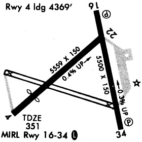
Runway Summary
| Runways: | 04/22 16/34 |
| Longest Runway: | 16/34 is 5501 ft (1677 m) long |
| Runways with an Instrument Approach: |
M18 Airport Runway Details
| Runway 04/22 | 5301 ft x 100 ft (1616 m x 30 m) | |
| Runway Length Source: | FAA as of 12/06/2012 | |
| Surface: | Concrete - Fair condition - No special surface treatment | |
Runway Weight Bearing Capacity (in thousands of pounds) |
||
| Single Wheel Landing Gear: | 40.0 | |
| Dual Wheel Landing Gear: | 55.0 | |
| Dual Tandem Wheel Landing Gear: | 105.0 | |
Runway 04 |
Runway 22 |
|
Elevation: |
330.0 | 351.0 |
Latitude: |
33-42-53.1700N | 33-43-28.5000N |
Longitude: |
093-40-10.1800W | 093-39-23.8000W |
|
Runway True Alignment: |
048 | 228 |
Glide Path Angle: |
0.0 degrees | 0.0 degrees |
Traffic Pattern: |
Left | Left |
Runway Markings Type: |
Nonprecision Instrument | Nonprecision Instrument |
Runway Markings Condition: |
Poor | Poor |
Object at End: |
TREES | |
Object Height: |
50 | |
Distance from End: |
250 | |
Object Centerline Offset: |
0 ft. left and right of centerline | |
Threshold Elevation: |
342.0 | 349.0 |
Displaced Threshold: |
1190 | 344 |
Threshold Latitude: |
33-43-01.1170N | 33-43-26.2000N |
Threshold Longitude: |
093-39-59.7881W | 093-39-26.8000W |
| Runway 16/34 | 5501 ft x 100 ft (1677 m x 30 m) | |
| Runway Length Source: | NGS as of 08/05/2008 | |
| Surface: | Concrete - Fair condition - No special surface treatment | |
| Runway Edge Lights: | Medium Intensity | |
Runway Weight Bearing Capacity (in thousands of pounds) |
||
| Single Wheel Landing Gear: | 40.0 | |
| Dual Wheel Landing Gear: | 55.0 | |
| Dual Tandem Wheel Landing Gear: | 105.0 | |
Runway 16 |
Runway 34 |
|
Elevation: |
359.2 | 340.4 |
Latitude: |
33-43-39.5525N | 33-42-46.4261N |
Longitude: |
093-39-24.7077W | 093-39-10.6121W |
|
Runway True Alignment: |
167 | 347 |
Glide Path Angle: |
3.0 degrees | 3.0 degrees |
Traffic Pattern: |
Left | Left |
Runway Markings Type: |
Nonprecision Instrument | Numbers Only |
Runway Markings Condition: |
Good | Good |
Object at End: |
TREE | TREES |
Object Height: |
32 | 29 |
Distance from End: |
1300 | 1200 |
Object Centerline Offset: |
0 ft. left and right of centerline | |
Visual Glide Slope Indicators: |
2-Light PAPI On Left Side Of Runway | 2-Light PAPI On Left Side Of Runway |
REIL: |
Yes | Yes |
Threshold Crossing Height: |
43 | 44 |
Services
Airframe Repair: |
Major |
Powerplant Repair: |
Major |
Fuel Available: |
100LL, Jet A+ |
Landing Fees: |
No |
Parking: |
Hangars and tiedowns available |
Maps & Diagrams
M18 Sectional
Flight Planning
at skyvector.com
at skyvector.com